
- Global Volcanism Program (GVP) page
- UWI-SRC on X.
- UWI-SRC fact sheet on the 2020-2021 eruption
December 14, 2025, 10:39 a.m., Pacific: I am updating all these posts, and while the GVP’s last report is from 2021, reportedly a slight increase in temperature was noted at the volcano’s summit in late 2024.
That news article, which appears to be from a credible source, is the only information I can find about that.
May 8, 2021: Yesterday, they lowered the alert level to Orange. Only the Red Zone is off limits now, except for those with special permits. However, lahars, some of them 15 feet deep, continue in river drainages.
Please see the bulletin from @NEMOSVG regarding the change in the alert level from Red to Orange. See the thread for the details regarding movement of residents. pic.twitter.com/GAJXPM9CWt
— UWISeismic Research (@uwiseismic) May 7, 2021
https://platform.twitter.com/widgets.js
May 1, 2021, 4:03 p.m. (Pacific): No explosions since April 22nd, but UWI-SRC continues to hold out the possibility in their daily updates, so I’ll keep this pinned for now.
Satellites have captured images of the dramatic summit changes, too:
New high-res #SAR image at #SVG acquired by @capellaspace on 27 April. Comparison with image of 10 April, during the paroxysm of the #LaSoufriereEruption, shows the changing physiognomy of the volcano. Follow @NEMOSVG @uwiseismic to stay up to date on hazards, which remain high. pic.twitter.com/0zGny6RuYn
— Raphael Grandin (@RaphaelGrandin) April 29, 2021
https://platform.twitter.com/widgets.js
Do you see a dome in there? Me, neither, and the boffiñs apparently haven’t identified one yet, per their Twitter feed, although they report that La Soufriere’s present seismicity is consistent with dome building.
Lahars are flowing, thanks to rainy weather recently.
April 22, 2021, 9:43 a.m., Pacific: Yesterday they summarized the eruption to date in a live Zoom press conference that later made its way to YouTube. It’s worth listening to, if you’re following events on St. Vincent, and not only for Rod Stewart’s delightful Scottish-Caribbean accent. (The “U-wee” is apparently how they refer to the University of the West Indies [UWI].)
Dr. Robinson calls the early phase plinian or subplinian. Mr. Stewart explains very simply what they see in the seismograms (incidentally, y’know how he leaves it with the telltale signs of an explosion coming? La Soufriere blew less than two hours ago. At last report, the plume was 8 km high and rising.)
Intermittent explosions like this, at lower intensity than the first blasts, are what can be expected now, and this could go on for weeks to months or even longer, they say. They hope that the volcano will settle down, build a dome, and go dormant, but they can’t rule out new magma rising and the whole process, including the plinian-style beginning, happening all over.
Me: After all, this thing started with a dome.
We’ll just have to wait and see.
April 20, 2021, 8:32 a.m., Pacific: No change, basically. Rather quiet, with possibility of explosion in the next week. In today’s update (starts at around 7:00), they mention a lahar seismic signal detected early this morning.
There’s going to be a lot more of that during the upcoming storm season.
Quit being such a diva, Madame Soufriere! (Image source)
I think the possibility of one of this volcano’s really big eruptions is still on the table, though very unlikely. La Soufriere will, hopefully and quite likely (based on recent eruptions), just build a dome and doze off again.
Still, after mentioning in an update earlier this week (see below) that there is indication of new magma moving in, the volcanologists haven’t mentioned it again, but the floater satellite, which had been removed, is now back in position.
It must be hell sometimes to be a volcanologist, to know what a volcano can do but not necessarily what it will do (it rarely gives warning), and meanwhile the Prime Minister is on the phone, you’ve got a press conference in a few minutes (during which you must translate complex facts and statistics into non-jargon), surviving farm animals in the Red and Orange Zones are starving, and your small country’s infrastructure is stressed to the limits, as are the people all crammed as far away from the volcano as they can get.
And there’s a pandemic going on.
Fortunately for SVG, this isn’t a Pinatubo 1991 situation, where everyone thought it was just a mountain until very shortly before it went Plinian. Rather, it is one of those extremely rare situations where highly trained scientists and other personnel both in and out of Science have dedicated their lives to understanding their fiery neighbor while it slept.
As a result of this and many other positive factors, as well as luck, there are to date zero direct human casualties from this eruption, compared to more than 1,350 in 1902.
Unfortunately, the Eternal Fool is there, too, but at least this presents an opportunity for some very human steam blow-off as well as an opportunity for public education!
Lead scientist monitoring the volcano sends a strong message to the young man who visited the summit of the La Soufriere volcano yesterday. pic.twitter.com/pbqPsdhiM8
— Lavern King 🇻🇨 (@Lavern_King) April 19, 2021
https://platform.twitter.com/widgets.js
Sigh. At least this guy isn’t getting many views on YouTube. Most people know better than to encourage such foolhardiness.
Anyway, the dramatic eruption in Iceland is drawing all eyes, but what most of us don’t realize is that there is a stellar example of volcanic crisis monitoring and communication going on in the Caribbean right now. It’s going to inspire a lot of research papers eventually, as well as maybe some career choices for volcanology/earth science among young people in SVG and elsewhere.
April 17, 2021, 7:42 p.m., Pacific: Yesterday, sixteen minutes after they issued the 6 a.m. update saying that explosive activity appeared to have ended, the volcano blew once again, though the plume’s estimated height was only half as high as last week’s 52,000-foot blasts.
There were reports that the edifice was deflating, per yesterday’s evening update, meaning that the stuff had emptied out, and certainly La Soufriere is much less active at the moment.
But in tonight’s update they report that GPS measurements now show that new magma is probably coming in. So it’s not over yet!
Some cool pictures of the crater:
First, diagrams on an older picture of the caldera, with the big 1979 dome sitting in it. Red is the new crater; yellow outlines the ultimate shape of what was a cute little lava donut back in December:

Now the way it looks today:
April 15, 2021, 5:44 p.m., Pacific: A little bit of good news! UWI-SRC reports the seismic tremor pattern has changed, explosive activity has apparently stopped just now, and the volcano might be building a dome, although they can’t confirm it visually yet.
Of course, lava domes tend to go boom, too, but this is a well-needed break for everyone in the area. Hope it lasts.
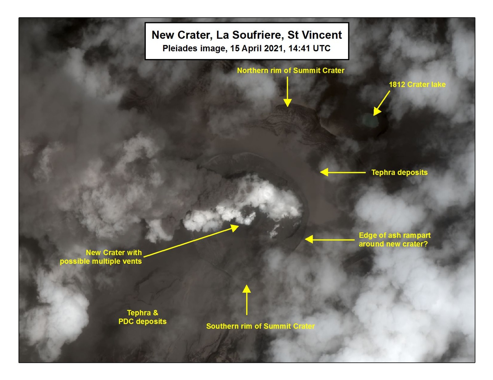
April 13, 2021, 6 p.m., Pacific: Well, here’s a reconstructed satellite view of the new crater. Almost everything seen in the videos of the original post below is gone!
A close up of the what the summit looks like currently as the eruption at #LaSoufriere continues. The new and old domes have been obliterated 🙁 https://t.co/Pg0M6YdruY
— UWISeismic Research (@uwiseismic) April 13, 2021
https://platform.twitter.com/widgets.js
And UWI-SRC just tweeted its scientific update for today; be sure to read the whole thread. There are pyroclastic flows down valleys from Larikai to Waalibou. However, the activity is weaker today, though there was a strong explosion this morning and things are expected to continue at this or more intense levels.
La Soufriere SCIENTIFIC UPDATE – 13/04/21 6:00PM (Thread)
1. Seismic activity changed with the explosive activity at 6:30 am on 13 April. Prior to the explosion, long-period (LP) earthquakes had been increasing in number.— UWISeismic Research (@uwiseismic) April 14, 2021
https://platform.twitter.com/widgets.js
I missed today’s streaming update but here is one from the weekend, in which Dr. Robertson discusses the initial pyroclastic flows (PDCs) with the prime minister. Those must have been devastating.
April 12, 2021, 8:37 a.m., Pacific: A live cam (h/t to Dr. Eric Klemetti, who advises to ignore the prediction thing on the right).
There are pyroclastic flows as the pressure at the vent fluctuates and the column temporarily collapses. Satellite views yesterday showed no signs of a dome (and no crater lake, as VDAP reminded them in a tweet reply today).
The volcano continues to erupt explosively and has now begun to generate pyroclastic density
currents. Explosions and accompanying ashfall, of similar or larger magnitude, are likely to
continue to occur over the next few days #lasoufriereeruption2021 #pyroclasticflows— NEMO SVG (@NEMOSVG) April 12, 2021
https://platform.twitter.com/widgets.js
April 11, 2021, 2:15 p.m., Pacific: The UWI-SRC director said in a news conference a little while ago that the explosive phase could go on for days to weeks.
This:
Animations of 1-minute #GOES16/#GOESeast Infrared images have been updated to cover the 1.5-day period 0900 UTC on 10 April to 1900 UTC on 11 April — GIF: https://t.co/ErawEjw1NC | MP4: https://t.co/X2FCR1Yc07
— Scott Bachmeier (@CIMSS_Satellite) April 11, 2021
https://platform.twitter.com/widgets.js
The sulfur cloud has reached Cabo Verde and it’s also up in the lower stratosphere, per Simon Carn.
The explosions have carved out a big crater, but let’s wait until things quiet down to check out the final size.
NEMO’s tweets this morning are downright depressing, but they do include the latest scientific update.
Views from the Observatory this morning taken by @VincieRichie. If being shared please credit: The UWI Seismic Research Centre. #lasoufriere #svg #uwi #redalert #stilldangerous pic.twitter.com/0nH4qMS2vk
— UWISeismic Research (@uwiseismic) April 11, 2021
https://platform.twitter.com/widgets.js
Per Reuters, power has been restored. Also, authorities are expecting some 20,000 people to be displaced within thd country for months.
April 10, 2021, 11:04 a.m., Pacific: h/t to Dr. Klemetti’s Twitter feed for this:
La Soufrière volcano erupting on St. Vincent from GOES, 30 min ago. Volcanic plume development is on a whole other temporal/energy level compared to atmospheric convection, or even wildfire PyroCb. 1-min meso scanning essential to resolve detail! #LaSoufriere #LaSoufriereEruption pic.twitter.com/MsIWTO8MmW
— Michael Charnick (@charnick_wx) April 10, 2021
https://platform.twitter.com/widgets.js
Words fail me. I’m just passing along information right now. And there is this, too:

___ 11:22 a.m., Pacific: It’s got its own floater satellite now.
Since at least ~9:50 UTC on April 10, #LaSoufrière has been producing stronger explosive events every ~1-2 hours. This #GOES16 Mesoscale image sequence shows the most recent pulse at ~16:30 UTC.
You can also view it using @UWCIMSS CSPP GeoSphere:https://t.co/6rSnkiP7ke; pic.twitter.com/t8qtHoJQkh
— Simon Carn (@simoncarn) April 10, 2021
https://platform.twitter.com/widgets.js
___ 10:37 a.m., Pacific: This is a bad eruption.
From inside the orange zone at 9:24 am this morning.
I don’t want to imagine what the red zone looks like that this point.#LaSoufriere #svg #vincy pic.twitter.com/9pzdfcc28p— Lavern King 🇻🇨 (@Lavern_King) April 10, 2021
https://platform.twitter.com/widgets.js
Video taken by me this morning from Cane Garden in the green zone overlooking Kingstown. pic.twitter.com/6zPuG0rpvD
— Lavern King 🇻🇨 (@Lavern_King) April 10, 2021
https://platform.twitter.com/widgets.js
April 9, 2021, 8:41 a.m., Pacific: They got as many of the 16,000 people in the red zone out as they could, though reportedly many are still there.
The blast came at 8:41 a.m., local time.
This video is from within the red zone.
I have lived to experience a natural disaster in the form of a volcanic eruption during a pandemic in my lifetime.#SVG #Soufriere #vincy pic.twitter.com/PyHS0j4iwL— Lavern King 🇻🇨 (@Lavern_King) April 9, 2021
https://platform.twitter.com/widgets.js
I’m only a layperson, but from historical reports, these Caribbean volcanoes (like many others) don’t fire off their biggest shots at first. No one authoritative that I follow is talking about what will happen next.
Perhaps Soufriere will soon quiet down, if this was only a small magma batch. Or perhaps it is just clearing its throat before escalating.
Here’s a report by Andersen and Flett on the 1902 eruption, published in 1903. According to Brown et al., 1,351 people died in that one from pyroclastic flows (the main killer), lahars (mudflows), and tephra. It would have been the major news of the day, if the death toll on Martinique (tens of thousands) hadn’t dwarfed it shortly afterwards.
Zebrowski (see reference list) also devotes a chapter to the 1902 Soufriere St. Vincent eruption, although that eBook is not free. (Since Zebrowski raises the point of La Soufriere St. Vincent, Mount Pelee, and possibly also Kick ’em Jenny all being active at once in 1902, and with them all restless now, it’s important to note that per the UWI Seismic Research Center Twitter account yesterday, each volcano has its own magma chamber and acts independently of the others, despite their being relatively close together.)
April 9, 2021, 9:58 a.m., Pacific: Per NEMO, they’re apparently trying to get people out of the orange zone, too, but ashfall limits visibility.
And a subsequent tweet from the volcanologists tells why:
Key messages from the latest press conference. #lasoufriere #SVG #Volcano #RedAlert pic.twitter.com/YZUeTK78QZ
— UWISeismic Research (@uwiseismic) April 9, 2021
https://platform.twitter.com/widgets.js
1 p.m., Pacific: Another big explosion at 2:45 p.m.


There has been an even larger explosion, per UWI-SRC, while I was putting up those images just now. They say the magma is coming in bursts. To a local observer, it appears continuous.
April 8, 2021, 4:52 p.m., Pacific: This is developing quickly. An evacuation was ordered three hours ago, per NEMO’s Facebook page (the website hasn’t been updated yet).
And here’s a recent tweet from the volcanologists:
Latest images of the dome taken before sunset from the summit camera by @VincieRichie shows the dome now glowing and the height is now estimated to be above the southern crater wall. Follow us and @NEMOSVG for more info. #volcano #svg #lasoufrière #redalert pic.twitter.com/t498dx6fWr
— UWISeismic Research (@uwiseismic) April 8, 2021
https://platform.twitter.com/widgets.js
Update, March 25, 2021:
The lead scientist monitoring the La Soufriere volcano in St Vincent, Professor Richard Robertson, says an increase in earthquakes at the site could suggest that an explosive eruption could happen soon.
La Soufriere has been erupting effusively since late December, and a new dome has formed alongside the one left inside the crater after the 1979 eruption of the volcano.
The National Emergency Management Organisation (NEMO) Wednesday warned residents of communities near to the volcano to heighten their preparedness in the event that it becomes necessary for them to evacuate at short notice.
NEMO said that scientists at the Belmont Observatory, have noted a change in seismic activity associated with the ongoing eruption of the volcano…
Original post:
This image doesn’t look like the news-making Soufriere Volcano on St. Vincent that you may have heard about lately.
The cone that’s erupting is only visible from the other side of this small Caribbean island. This image does give you some idea of how volcanism dominates St. Vincent and its topography.
Towns and other settlements here can only exist along the coast. There isn’t really anywhere to go during an eruption.
The central part of the island is all volcanoes, running north-south and ranging in age from about 3 million years old (and extinct) in southern St. Vincent to the young — fifty thousand years or less — Soufriere cone in the north. (Le Friant et al.)
Soufriere is the smaller, active part of a larger volcanic structure called Somma that goes back hundreds of thousands of years and is still being studied. (Le Friant et al.)
Let’s focus on the Soufriere Crater that you can’t see in the above image, with the help of a video filmed in the crater in 2016. The narrator is Dr. Richard Robertson of the University of the West Indies Seismic Research Centre (UWI-SRC):
Professor Robinson is reassuring local people because memories of 1979 are still alive on St. Vincent:
So, what is all the current fuss about?
This:
Soufriere St. Vincent is monitored and volcanologists therefore knew beforehand that something was on the way, but let’s face it: that dome is photogenic, and it caught the world’s laypeople by surprise during a slow news period at year’s end.
Wow!
Soufriere St. Vincent was guaranteed to become a major news story even before factoring in the volcano’s violent history and its probably coincidental major eruption in 1902 along with Mount Pelee on Martinique, two islands away (Pelee, which we’ll check out next Sunday, is currently stirring a little).
Where are things at now?
For one thing, Dr. Robinson is doing more video outreach:
Volcanologists also are putting up more equipment on and around Soufriere to collect data that will help them and others, including government at all levels as well as the UWI-SRC, National Emergency Management Organisation (NEMO), and Caribbean Disaster Emergency Management Agency (CDEMA), to manage the crisis.
Making this task much more difficult is the fact that they are working at the center of an international whirlwind of public interest and excitement.
Unfortunately, this also includes some misinformation.
Please be advised that the information in this article is inaccurate. There is currently NO evacuation order in St Vincent. Please continue to refer to the authorities (NEMO SVG, UWI-SRC) for official updates regarding La Soufrière https://t.co/NT5vAZAQr0
— UWISeismic Research (@uwiseismic) January 1, 2021
https://platform.twitter.com/widgets.js
Several media sources, including Reuters, have made this error, too.
“Be ready to evacuate” does not mean “go!”.
Still, the mistake is somewhat understandable. Soufriere St. Vincent isn’t playing fair. Instead of following the script — volcano stirs, scientists issue warning and almost everybody gets out, volcano explodes — Soufriere St. Vincent just sits there oozing lava at us.
This actually is normal behavior at many otherwise explosive volcanoes — Soufriere had a totally effusive (lava flow) eruption in 1971, for instance.
As we’ll see below, this volcano alternates explosions and flows.
But volcanological facts of life are very difficult to convey in a world of deadlines, intense competition, and the need to grab a distracted reader’s attention quickly with your lede, written using the fewest words possible.
Volcano eruptions are problematical for the media as well as for scientists and the authorities.
Everybody, including editors and fact checkers, must be on their toes 24/7.
The Soufriere St. Vincent eruption thus far (early Sunday morning, January 3rd) is quiet.
The human drama around it at lay, scientific, and government levels is blowing a storm, thanks to the amount of information we’re all immersed in from the Internet and various social media outlets.
Let’s just kick back and learn some of the basics about this volcano.
Location:
13.33° N, 61.18° W, Saint Vincent, Saint Vincent and the Grenadines, Windward Islands, Lesser Antilles. The GVP Volcano Number is 360150.
Nearby Population:
Per the Global Volcanism Program website:
- Within 5 km (3 miles): 1,491.
- Within 10 km (6 miles): 15,327.
- Within 30 km (19 miles): 103,882.
- Within 100 km (62 miles): 291,476.
Current Status:
Orange (second highest of four-point system).
Eruptions:
- Eruption styles: Explosive “St. Vincent-style”eruptions with lots of material released very quickly — at least four since the 1700s — or effusive lava flows erupting less material (frequent). (Le Friant et al.; Robertson)
- Biggest recorded event: VEI 4 blasts in
1979 and1812 and 1902, per the Global Volcanism Program. According to Robertson, volcanic deposits on the island suggest that Soufriere may also have plinian and ultraplinian eruptions at millennial-scale intervals, though this hasn’t happened during the brief 250 years of documented human history here. Addendum, April 12, 2021: Yesterday the director of UWI-SRC said during a press briefing that the current activity is more energetic than 1902’s. So we are probably watching La Soufriere’s “Big One” right now. - Most recent eruption: Ongoing lava dome eruption.
- Past history: See the Global Volcanism Program for details.
At #LaSoufriere #StVincent this project worked with @uwiseismic & @NEMOSVG from 2014-2018. NEMO asked us to make some communication films and @VincieRichie shared his expertise about past eruptions on a tour of the island.
(VEI = Volcanic Explosivity Index) 1/8 pic.twitter.com/KkUrYOvHYH— STREVA (@StrevaProject) April 12, 2021
https://platform.twitter.com/widgets.js
This morning, April 12, volcanologist David Pyle tweeted this graphic of La Soufriere’s known history. The whole thread is worth a look.
Monitoring:
Monitoring: UWI-SRC (Twitter) and NEMO St. Vincent and the Grenadines
(Facebook). The UWI-SRC does have a website, but I noticed over the weekend that it isn’t updated as often as the social media (which are probably what Vincentians follow in real time); UWI-SRC is on Facebook, too.Original post edited on April 12, 2021.
Feature image: Richard Robinson
Sources:
Anderson, T., and Flett, J. S. 1903. Report on the eruptions of the Soufrière, in St. Vincent, in 1902, and on a visit to Montagne Pelée, in Martinique, Part I. Philosophical Transactions of the Royal Society of London, A.329 (200): 353-553, published by Dulau and Company, London.
https://play.google.com/store/books/details?id=o7oNAAAAYAAJBrown, S.K.; Jenkins, S.F.; Sparks, R.S.J.; Odbert, H.; and Auker, M. R. 2017. Volcanic fatalities database: analysis of volcanic threat with distance and victim classification. Journal of Applied Volcanology, 6: 15.
Global Volcanism Program, 2020. Report on Soufriere St. Vincent (Saint Vincent and the Grenadines). In: Sennert, S K (ed.), Weekly Volcanic Activity Report, 23 December-29 December 2020. Smithsonian Institution and US Geological Survey.
https://volcano.si.edu/showreport.cfm?doi=GVP.WVAR20201223-360150Le Friant, A.; Boudon, G.; Arnulf, A.; and Robertson, R. E. 2009. Debris avalanche deposits offshore St. Vincent (West Indies): impact of flank-collapse events on the morphological evolution of the island. Journal of Volcanology and Geothermal Research, 179(1-2): 1-10.
Oregon State University: Volcano World. 2020. Soufriere St. Vincent. http://volcano.oregonstate.edu/soufrière-st-vincent Last accessed January 2, 2021.
Pyle, D. M.; Barclay, J.; and Armijos, M. T. 2018. The 1902–3 eruptions of the Soufrière, St Vincent: Impacts, relief and response. Journal of Volcanology and Geothermal Research, 356: 183-199.
Robertson, R. E. 1995. An assessment of the risk from future eruptions of the Soufriere volcano of St. Vincent, West Indies. Natural Hazards, 11(2): 163-191.
Wilkinson, E.; Lovell, E.; Carby, B.; Barclay, J.; and Robertson, R. E. 2016. The dilemmas of risk-sensitive development on a small volcanic island. Resources, 5(2): 21.
Zebrowski, Jr., E. 2002. The Last Days of St. Pierre: The Volcanic Disaster That Claimed Thirty Thousand Lives, Chapter 8: La Soufriere. Retrieved from https://play.google.com/store/books/details?id=RFpPcNXT6IoC
