
Edited May 7, 2023
This Caribbean volcano is no relation of the Hawaiian fire goddess.
Known as Bald Mountain because of its rocky summit, it acquired the nickname pelé, “peeled,” during the island of Martinique’s early days as a French colony. Then, a mapmaker accidentally stuck an extra “e” in there. (Zebrowski)
Since this happened centuries before the invention of technologies that would make error corrections easy and inexpensive, everybody just rolled with “Montagne Pelee.”
Why not? While the big mountain taking up most of northern Martinique’s landscape was obviously a volcano, it wasn’t very important. There were some fumaroles up there, and a couple of steam-driven minor eruptions happened in 1792 and 1851, but nobody got hurt.
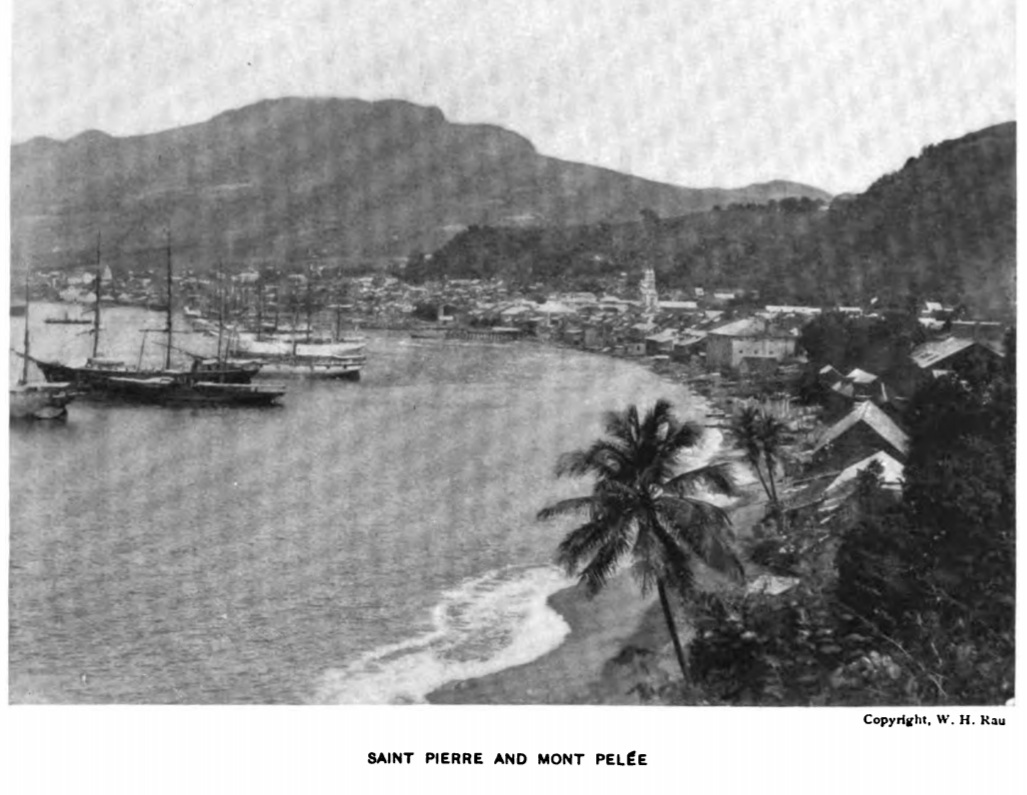
Saint Pierre and Mont Pelee, undated but probably in the nineteenth century, judging from ships. Yes, the harbor is deep enough for big ships to get that close to shore. Montagne Pelee is not stereotypically pointy here because of landslides (Clouard et al.) as well as occasional flank collapses, the last about nine thousand years ago per the GVP. (Image: Heilprin, 1903)
Old Bald Mountain was apparently just dozing its way through senility to eventual extinction. There were other things to worry about: hurricanes, earthquakes, and fluctuations in the international market price of sugar made from Martinique’s sugarcane.
Pelee’s quiet summit area was a popular hangout in good weather. Paths led up there along stream courses that were steep but cooler than the coastal lowlands and filled with tropical scenery.
You could cool off after your climb with a dip in the crater lake, though its clear, lifeless water was only four feet deep. There also was another summit crater, called Dry Lake, l’Etang Sec, but that wasn’t as accessible for picnicking or very interesting to visit. Many people didn’t even know about it. (Zebrowski)
From the top of Pelee, which is the highest point on Martinique, views were superb, with green rolling hillsides nearby that were checker-boarded with plantations and villages; the red-roofed, yellow-stuccoed city of Saint Pierre — “the pearl of the Antilles” — stretching gracefully along the curved coast, four thousand feet below, while its deep harbor bustled with ferries and international cargo ships; and the blue Atlantic Ocean on one side and Caribbean Sea on the other.
The White River, Riviere Blanche, flowed out of l’Etang Sec and entered the sea near the huge Guerin sugar factory . . .
Well, you can see where all this is going.

A huge lahar from l’Etang Sec — the eruption site — just about filled in the White River valley and buried hundreds of people, including most of the Guerin family and their employees, on May 5th. (Image: Heilprin, 1908)
By noon on May 8, 1902, Saint Pierre lay in smoking ruins. Many burned hulks sat at the bottom of the harbor. Only the upper part of the Guerin factory smokestack protruded through a field of deep volcanic mud. Tens of thousands of people were dead.
And Pelee kept roaring.
In fact, it went on to have two explosions even more powerful than the one at 8:02 a.m. on May 8th that had destroyed Saint Pierre. That lethal cloud had killed all but one or two people in the city, but it at least had left ruined infrastructure behind.
The blast on May 20th flattened almost everything that remained.
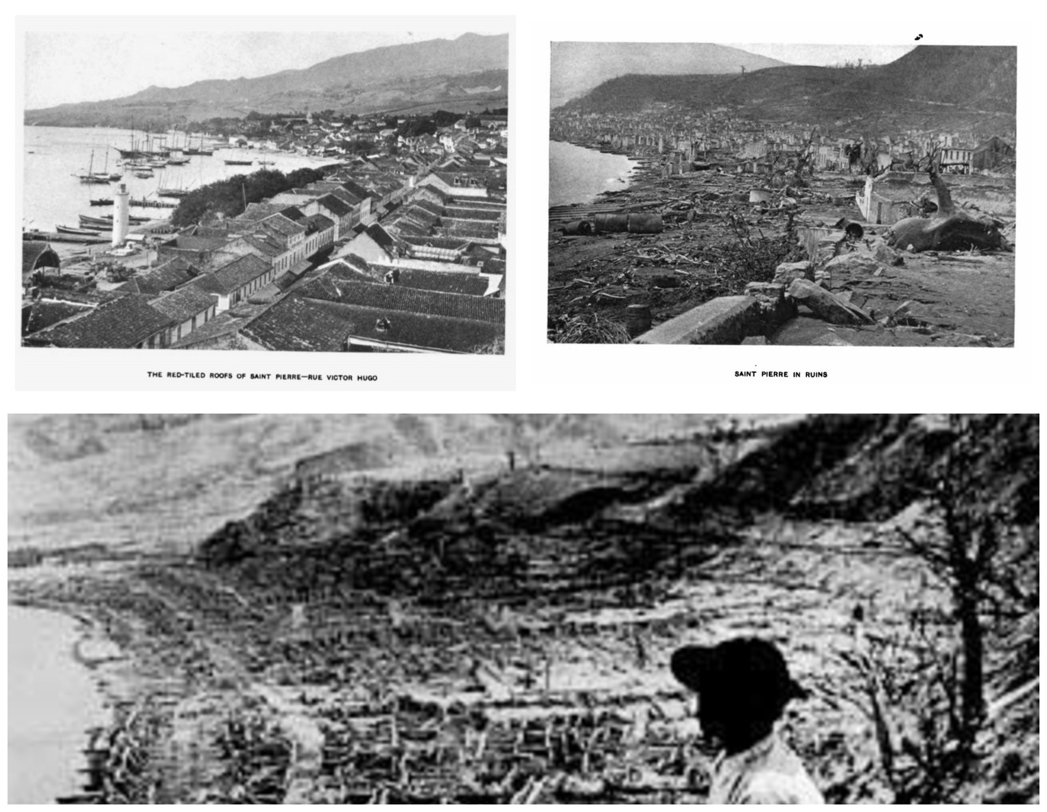
Top left: Rue Victor Hugo, the main business street. It ran parallel and very close to the harbor; Top right: Saint Pierre after the May 8th blast; Bottom: Part of the famous picture showing a completely devastated Saint Pierre. (Images: Heilprin 1903, 1908)
Another blast on August 30th went in a slightly different direction, killing about a thousand people in and around the village of Morne Rouge.
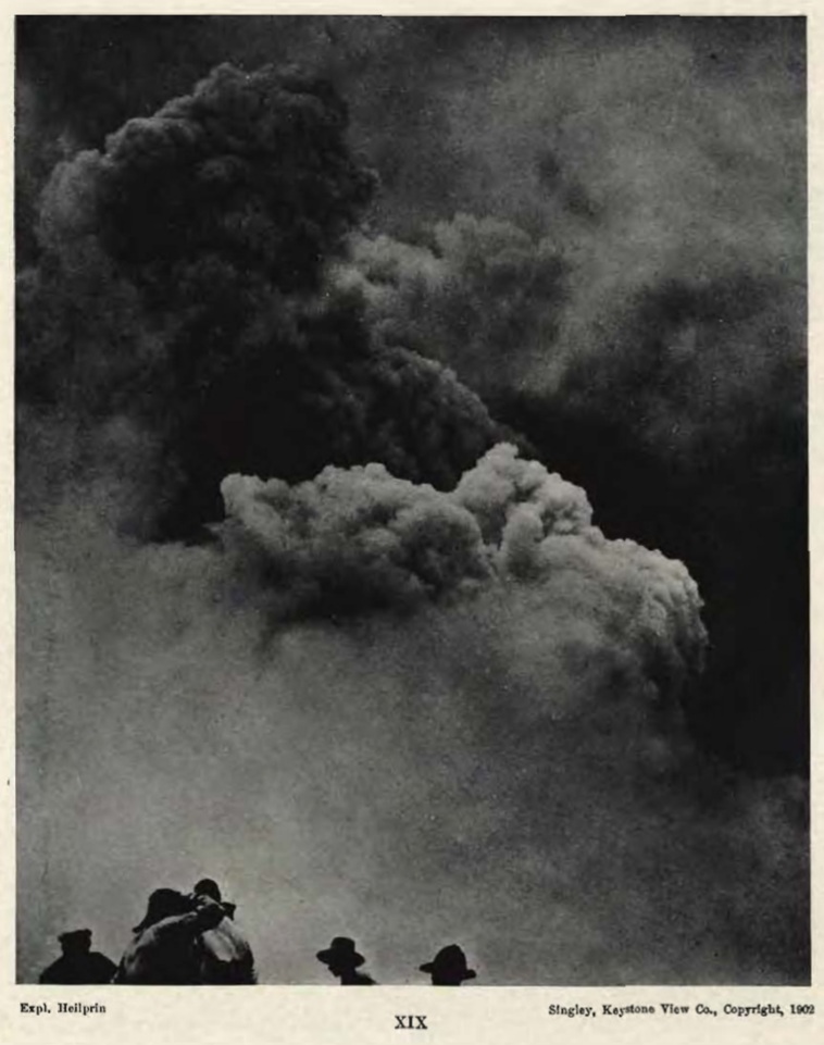
Per the caption, this was taken (location not given) about six hours before Morne Rouge was hit on August 30th. (Image: Heilprin, 1908)
All the world could do, besides sending aid and investigators, was to echo the question of Gaston Landes, professor at Saint Pierre’s Lycee Colonial and, per Zebrowski, the most scientifically knowledgeable person on the island, as he lay dying of burns on May 8th: “What on earth has happened?”
Landes had not even seen the “black cloud” that many people described issuing from Pelee’s summit and then traveling down to and through Saint Pierre, all in the space of about five minutes (its cause was the explosive destruction of a lava dome in l’Etang Sec, future studies would show).
A similar “black cloud” had raced down the slopes of La Soufriere Volcano, which was also having a major eruption on St. Vincent, two islands down from Martinique. This other deadly tragedy had struck at around 2:30 p.m. on May 7th.
How could these fiery death clouds travel so much farther and faster than any other type of avalanche? Why were they so deadly?

A. Lacroix, in Heilprin , 1908
That’s the question worth concentrating on here, although other parts of the science now known as volcanology can also trace their roots to ground-breaking studies done at Pelee and La Soufriere during and after their 1902 eruptions.
By setting up on a hill several miles from Pelee, waiting patiently all day under the tropical sun and enduring the smell of death from nearby Saint Pierre, and then working very quickly and efficiently with 1902-style photographic equipment when a cloud appeared on the volcano’s flank, Alfred Lacroix was able to document how these nuees ardentes— we call them pyroclastic density currents, or flows — develop and travel.
Digital photography has helped volcanologists a lot!
From those images and other field observations, Lacroix realized that the clouds of fiery material travel on a bed of superheated gas and so aren’t slowed down very much by friction.
This also explains why they keep on going after reaching the coast, engulfing ships and causing tsunamis.
Today, the summit of Pelee is very different, but the view is still spectacular. And now a volcano observatory sits nearby, constantly monitoring this dangerous volcano’s vital signs.
Location:
14.809° N, 61.165° W, Martinique, West Indies, France. The GVP Volcano Number is 360120.
Nearby Population:
Per the Global Volcanism Program (GVP) website:
- Within 5 km (3 miles): 251
- Within 10 km (6 miles): 5,025
- Within 30 km (19 miles): 382,633
- Within 100 km (62 miles): 609,576
Current Status:
Although Pelee has slumbered for almost a century now, with its fumaroles dying out in the 1970s, experts raised the alert level to Yellow, second highest on a four-stage system, in early December 2020 because of some subtle changes in seismicity that volcanologists are trying to interpret. They note that no other parameters, like gas levels and hydrology, have changed. (OVSM-IPGP: see “Monitoring”) No eruption appears imminent, but they aren’t taking any chances.
Eruptions:
- Eruption styles:
Steam-driven phreatomagmatic eruptions occurred in the eighteenth and nineteenth centuries.

Pelee’s 1902 dome, seen here from what was once south Saint Pierre, was FABULOUS at times, rising almost 1,200 feet above the rim of l’Etang Sec! (Image: Heilprin, 1908)
Volcanic deposits suggest that Montagne Pelee built its present cone using one of two magmatic modes: either plinian-style or dome-forming eruptions. (Lefriant et al., 2003; Solaro et al.)
Believe it or not, the 1902 eruption was one of the less intense dome-construction eruptions! No Plinian eruptions are documented in written records; Clouard et al. report that the last such event here happened some 600 years ago.
- Biggest recorded event: The VEI 4 1902-1905 eruption.
- Most recent eruption: Pelee had a VEI 3 dome-forming eruption from September 1929 to December 1932. The roughly 3,200 residents of Saint Pierre were evacuated but no pyroclastic flows entered the town. (Zebrowski)
- Past history: See the GVP for details. Of note, they report that Pelee has had more than twenty large eruptions over the last five thousand years, and thick pyroclastic deposits blanket its slopes.
Pelee tends to sleep for centuries in between major eruptions (Tanguy) — the last big one before 1902, for example, was in the 1600s.

Monitoring:
The Martinique Volcanological and Seismological Observatory/Paris Institute of Global Physics (OVSM-IPGP)
Here is their real-time cam — scroll down (autotranslated).
Featured image: Damien Verrier/Shutterstock
Sources:
Boudon, G.; Villemant, B.; Le Friant, A.; Paterne, M.; and Cortijo, E. 2013. Role of large flank-collapse events on magma evolution of volcanoes. Insights from the Lesser Antilles Arc. Journal of Volcanology and Geothermal Research, 263: 224-237.
Brown, S.K.; Jenkins, S.F.; Sparks, R.S.J.; Odbert, H.; and Auker, M. R. 2017. Volcanic fatalities database: analysis of volcanic threat with distance and victim classification. Journal of Applied Volcanology, 6: 15.
Brunet, M.; Le Friant, A.; Boudon, G.; Lafuerza, S.; and others. 2016. Composition, geometry, and emplacement dynamics of a large volcanic island landslide offshore M artinique: From volcano flank‐collapse to seafloor sediment failure?. Geochemistry, Geophysics, Geosystems, 17(3): 699-724.
Clouard, V.; Athanase, J. E.; and Aubaud, C. 2013. Physical characteristics and triggering mechanisms of the 2009–2010 landslide crisis at Montagne Pelée volcano, Martinique: implication for erosional processes and debris-flow hazards. Bulletin de la société géologique de France, 184(1-2): 155-164.
Heilprin, A. 1903. Mont Pelee and the Tragedy of Martinique. J. B. Lippincott Company, Philadelphia. Second edition. Retrieved from https://books.google.com/books/about/Mont_Pelée_and_the_Tragedy_of_Martiniqu.html?id=yMy7AAAAIAAJ&printsec=frontcover&source=kp_read_button .
___. 1908. The Eruption of Pelee: A Summary and Discussion of the Phenomena and Their Sequels. Geographic Society of Philadelphia, J. B. Lippincott company. Retrieved from https://issuu.com/scduag/docs/eruptionof .
Le Friant, A.; Boudon, G.; Deplus, C.; and Villemant, B. 2003. Large‐scale flank collapse events during the activity of Montagne Pelée, Martinique, Lesser Antilles. Journal of Geophysical Research: Solid Earth: 108(B1).
Rosen, J. 2018. Benchmarks: May 8, 1902: The deadly eruption of Mount Pelee. https://www.earthmagazine.org/article/benchmarks-may-8-1902-deadly-eruption-mount-pelee Last accessed January 9, 2021.
Solaro, C.; Boudon, G.; Le Friant, A.; Balcone-Boissard, H.; and others. 2020. New insights into the recent eruptive and collapse history of Montagne Pelée (Lesser Antilles Arc) from offshore marine drilling site U1401A (IODP Expedition 340). Journal of Volcanology and Geothermal Research, 403: 107001.
Tanguy, J. C. 1994. The 1902–1905 eruptions of Montagne Pelée, Martinique: anatomy and retrospection. (Abstract only.) Journal of volcanology and geothermal research, 60(2): 87-107.
Wikipedia. 2021. Mount Pelee. https://en.wikipedia.org/wiki/Mount_Pelée Last accessed January 5, 2021.
___. 2021. The 1902 eruption of Mount Pelee. https://en.wikipedia.org/wiki/1902_eruption_of_Mount_Pelée Last accessed January 5, 2021.
Zebrowski, Jr., E. 2002. The Last Days of St. Pierre: The Volcanic Disaster That Claimed Thirty Thousand Lives. Retrieved from https://play.google.com/store/books/details?id=RFpPcNXT6IoC
