

Let’s get oriented here. Toba caldera is obvious, but check out Sinabung and Sibayak (upper left), too. (Image: Mucek et al., CC BY 4.0)
In this 2017 satellite image, Toba is the watery ellipse with an island in the middle. Mount Sinabung is the small spot that it’s pointing to (volcanic ash makes this erupting little volcano bright).
We’ve already met each of these two very impressive north Sumatran volcanoes individually. Now it’s time to take a brief look at them together.
After all, they’re close neighbors; a young supervolcano and very active “normal” volcano, respectively; and volcanologists study them intensively.
There’s still a lot to learn here.
While the boffins use technical terms, some of the important questions they’re addressing can be put into plain English.
Are Toba and Sinabung connected?
Well, they’re only 20 miles apart, but the current consensus is that these are two separate volcanoes. (Mucek et al.)
This, despite a connection in time:
- Toba had its Younger Toba Tuff supereruption about 74,000 years ago, resulting in a huge hole in the ground, also known as a caldera. After that, the volcano’s magmatic system had some low-level activity as equilibrium was restored. This happens at all large calderas. (Mucek et al.) All the names around Toba in the image, above right, point out features that developed during this time.
- Just to the northwest, Sinabung started to form soon after the supereruption. Down through the years, pyroclastic density currents and lava flows have constructed a typical pointy-peaked stratovolcano here.
That timing of Sinabung’s appearance — right after Toba’s last supereruption — is interesting, but it might be coincidence.
There are LOTS of volcanoes on Sumatra.
And Sinabung has sometimes been linked to another volcano: nearby Sibayak and its associated Singkut Caldera.
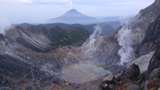
Sinabung, in the background, doesn’t look so little in this 2015 view from Sibayak, home to Sumatra’s first geothermal production field. Note the colorful tents in the foreground for scale. I couldn’t find any information about Singkut but gathered that Sibayak is one of this caldera’s cones. (Image: Palma Bernardo Alexius Hutabarat, CC BY 2.0)
Thanks to complex geological forces in the Barisan Mountains, many fire mountains here do cluster together.
But in 2017 Mucek et al. reported that they had found geochemical evidence linking Sinabung to Toba.
It’s not an open-and-shut case, though.
The team can’t explain how Sinabung’s current eruptions could tap Toba’s magma, though they believe this is indeed happening.
The obvious next step is to try and find a connection between the Toba and Sinabung magma chambers.
Seismic tomography lets us see structures like that, even though they’re buried miles underground.
You’ve experienced tomography if you’ve ever had an ultrasound, MRI, or a CT.
Basically, experts use seismic waves generated by earthquakes or ambient noise to look into the Earth just as physicians use sound waves, radio waves (MRI), or x-rays (CT) to peer into our bodies.
Luckily for us, healthcare workers don’t need to do this. Ambient noise can be traffic, wind, sea and lake waves, air pressure changes, and other things that probably aren’t as much fun as smashing something with a sledgehammer. The ground underneath Toba has been studied both with ambient noise and seismic waves (which can “see” much deeper).
There are some problems with using this technique on Toba and Sinabung’s magma chambers, though.
Where’s the magma chamber?
It seems obvious enough at Toba.
Today we can all see part of the walls and floor of the magma chamber that hosted the Younger Toba Tuff eruption 74,000 years ago.
But it’s a different story when you look at Toba with seismic tomography.
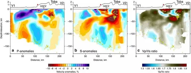
Just because you can “see” down there doesn’t automatically mean you know what you’re looking at. (Koulakov et al., CC BY 4.0)
Well, what else could you expect from a supervolcano?
Experts from a number of geological disciplines are still trying to understand Toba Caldera and its plumbing system.
*****
At Sinabung, researchers have found:
. . . an area of low seismicity . . . at depths of around [3 miles] slightly south of the summit . . . most likely . . . hot material with some partial melt that may be the source for the 2010 phreatic eruptions and continued unrest . . .
— Indrastuti et al.
However, nowhere in this paper do they refer to that area as a magma chamber or reservoir.

They used a variety of seismic tomography techniques at Sinabung and also included earthquakes (black dots). This was the least complicated figure in the paper — I have no idea what’s going on. (Figure 8, Indrastuti et al., CC BY-NC-ND 4.0)
So, we can’t settle the question of possible connections between Toba and Sinabung with a quick look at their magma chambers.
It’s going to take more time and work both in the field and in the lab.
And that work will get done, no matter how long it takes, because disaster planners would have to rethink their options at both volcanoes if such a connection were proven to exist.
What’s the hazard at Toba and Sinabung?
Experts already have these two volcanoes carefully monitored.
Toba currently is at a “normal” level, while Sinabung is at a level 3 alert.
For obvious reasons, though these scenes are from the intense activity phase in 2014. Sinabung is a little quieter at the moment.
Mucek et al are concerned that the similarity in Toba and Sinabung eruptive products could mean that Toba’s magmatic system extends much farther north than anyone has suspected up til now.
That would be a problem and not just in terms of extra magma.
Toba has some fumaroles in a few places, but it hasn’t been active on even a small scale for thousands of years. If Sinabung is ever identified as a cone of Toba, then this giant will have to be considered as active and in eruption.
That’s not the end of the world, by any means. Supervolcanoes do have “non-super” eruptions — much more frequently, in fact, than big ones.
Since nothing would have changed in the field, tourists presumably could continue to visit Lake Toba, and Sinabung’s neighbors would continue to be forced to coexist somehow with its tempestuous behavior.
The worrisome part is that very little is known about supervolcanoes and their largest eruptions.
A proven connection between Toba and Sinabung would be unusual, throwing some doubt on how accurate are the hazard models in use today.
But if it exists, such a connection would also provide more insight into supervolcanoes and how they work. That, in turn, would enable experts to better understand Toba and its risks.
*****
However, this is just one paper, and the situation is still under debate. We’ll just have to see how it goes.
So much more information about Toba and Sinabung needs to be uncovered!
It’s encouraging to know that both volcanoes are closely watched and under investigation by some of the best minds on the planet.
Edit, August 12, 2019: Due to a coding error on my part, the image credit and source list didn’t post with this morning. Sorry!
Featured image: Paul Quast, CC BY 2.0.
Sources:
In addition to those in the linked posts on Toba and Sinabung:
Donovan, A., and Oppenheimer, C. 2016. Imagining the Unimaginable: Communicating Extreme Volcanic Risk, in Observing the Volcano World, eds. Fearnley, C. J.; Bird, D. K.; Haynes, K; McGuire, W. J.; and Jolly, G., 149-163. Springer, Cham.
Gunawan, H.; Budianto, A.; Prambada, O.; McCausland, W.; and others. 2017. Overview of the eruptions of Sinabung eruption, 2010 and 2013–present and details of the 2013 phreatomagmatic phase. Journal of Volcanology and Geothermal Research. https://www.sciencedirect.com/science/article/pii/S0377027317304900
Indrastuti, N.; Nugraha, A. D.; McCausland, W. A.; Hendrasto, M.; and others. 2019. 3-D seismic tomographic study of Sinabung Volcano, Northern Sumatra, Indonesia, during the inter-eruptive period October 2010–July 2013. Journal of Volcanology and Geothermal Research. https://www.sciencedirect.com/science/article/pii/S0377027319301507
Jatnika, J.; Nugraha, A. D.; and Wandono. 2015. Preliminary result of P-wave speed tomography beneath North Sumatera region (abstract only). In AIP Conference Proceedings (Vol. 1658, No. 1, p. 030018). AIP Publishing.
Jaxybulatov, K.; Shapiro, N. M.; Koulakov, I.; Mordret, A.; and others. 2014. A large magmatic sill complex beneath the Toba caldera. science, 346(6209): 617-619.
Koulakov, I.; Kasatkina, E.; Shapiro, N. M.; Jaupart, C.; and others. 2016. The feeder system of the Toba supervolcano from the slab to the shallow reservoir. Nature Communications, 7: 12228.
Masturyono, M. R.; Wark, D. A.; Roecker, S. W.; and Fauzi, G. 2001. Distribution of magma beneath Toba Caldera, North Sumatra, Indonesia, constrained by 3-dimensional P-wave velocities, seismicity, and gravity data. Geochemistry, Geophysics, Geosystems, 2: 2000GC0096.
Mucek, A. E.; Danišík, M.; de Silva, S. L.; Schmitt, A. K.; and others. 2017. Post-supereruption recovery at Toba Caldera. Nature Communications, 8: 15248.
Pallister, J.; Wessels, R.; Griswold, J.; McCausland, W.; and others. 2018. Monitoring, forecasting collapse events, and mapping pyroclastic deposits at Sinabung volcano with satellite imagery. Journal of Volcanology and Geothermal Research. https://www.sciencedirect.com/science/article/pii/S0377027318301938
Yoshimoto, M.; Nakada, S.; Hokanishi, N.; Iguchi, M.; and others. 2013. Eruption history and future scenario of Sinabung volcano, North Sumatra, Indonesia. IAVCEI, Scientific Assembly-July, 20-24.
