Update for today on the Popocatepetl page:
February 17, 2019, 4:23 p.m., Pacific: Well, I’ve waited all day, but Popo settled down into a steady venting of light ash and vapors overnight, per the time-lapse videos, and except for one rather ashy-looking puff this morning, has remained at that level ever since.
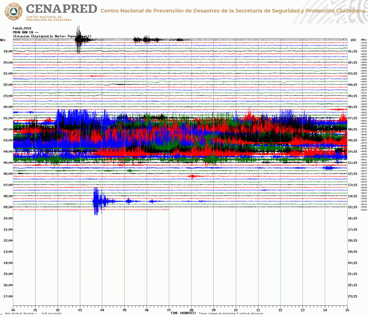
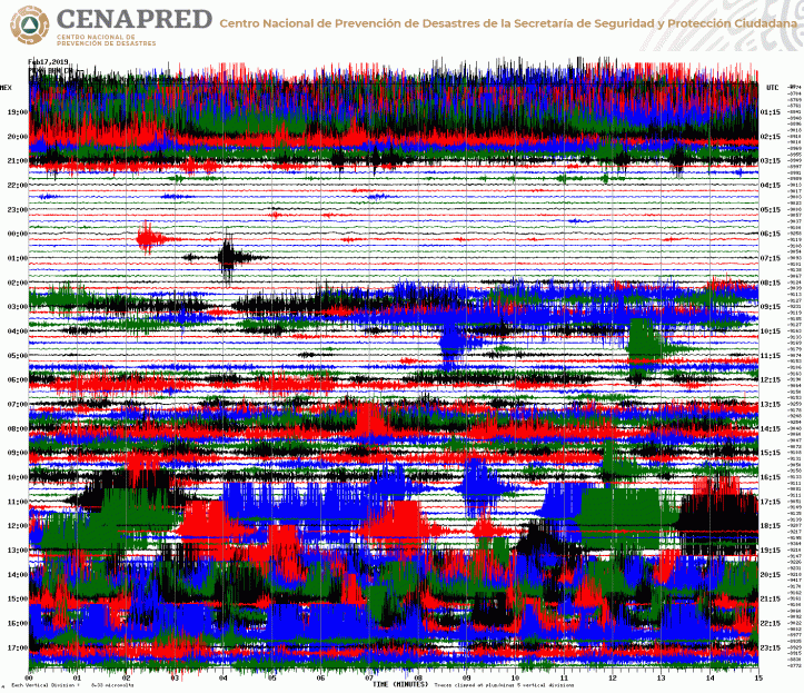
However, that apparently steady and smooth plume is being caused by some sort of inner turmoil–I have no idea what, but this has been going on all day, per the Chipiquixtle webicorder:
However, there’s no change in deformation in this morning’s CENAPRED graphic. Check out that tremor, though!

Yesterday’s posts:
Update, February 16, 2019, 3:54 p.m., Pacific: Check out live eruption video here
The alert level continues at Yellow Phase 2 — it’s impressive looking, especially with a setting sun behind the ash column, but there isn’t a lot of force behind it. . . yet.
El #Semáforo de alerta volcánica del #Popocatépetl continúa en amarillo fase dos. pic.twitter.com/T7Ad7AaiR7
— PC Estatal Puebla (@PC_Estatal) February 16, 2019
https://platform.twitter.com/widgets.js
Here’s the view from Mexico City an hour or two earlier:
Así el volcán @Popocatepetl_MX esta tarde de sábado. pic.twitter.com/cy64Ws8hpc
— Fernando Canales F (@FerCanalesF) February 17, 2019
https://platform.twitter.com/widgets.js
Earlier post:
Day before yesterday, this volcano, which is near Mexico City and several densely populated states and has been slowly ramping up activity since it awoke back in 1994, got a little more active, and that continues. Check out the Popocatepetl page here for much information and relevant links. The monitoring agency CENAPRED issues its updates around 11 a.m. local time; there’s a link on the page to those updates.
Update, 9 a.m., Pacific: Just checked the VAAC advisory page and found this from almost an hour ago (1614 UTC)–last night’s cloud has just cleared the Pacific coast:
FVXX23 KNES 161614
VA ADVISORY
DTG: 20190216/1614ZVAAC: WASHINGTON
VOLCANO: POPOCATEPETL 341090
PSN: N1901 W09837AREA: MEXICO
SUMMIT ELEV: 17802 FT (5426 M)
ADVISORY NR: 2019/143
INFO SOURCE: GOES-EAST. WEB CAM. NWP MODELS.
CIMSS VOLCAT.ERUPTION DETAILS: ONGOING VA EMS
OBS VA DTG: 16/1537Z
OBS VA CLD: SFC/FL210 N1919 W09931 – N1907 W09841
– N1844 W09934 – N1859 W10007 – N1916 W10000 –
N1919 W09931 MOV NW 10-15KT SFC/FL220 N1901
W10304 – N1805 W10231 – N1700 W10226 – N1635
W10312 – N1637 W10445 – N1613 W10604 – N1737
W10533 – N1901 W10304 MOV N 5KTFCST VA CLD +6HR: 16/2130Z SFC/FL210 N2009 W09935
– N1937 W09912 – N1927 W10013 – N1949 W10040 –
N2005 W10014 – N2009 W09935 SFC/FL220 N1911
W10300 – N1743 W10220 – N1650 W10420 – N1640
W10602 – N1829 W10541 – N1911 W10300FCST VA CLD +12HR: 17/0330Z SFC/FL210 N2118
W10023 – N2047 W09946 – N2027 W10040 – N2051
W10110 – N2118 W10023 SFC/FL220 NO ASH EXPFCST VA CLD +18HR: 17/0930Z SFC/FL210 NO ASH
EXPNO ASH EXPRMK: REMNANT VA OBS JUST OFF MEX COAST IS LGT AND
IS FCST TO DISP WITHIN T+12HRS. NEWER VA EMS IS
CLEARLY OBS IN VIS EXTD TO NEAR 80NM W OF SUMMIT
AND IS FCST TO GENLY MOV NNW THRU T+12HRS. FCST
BASED OFF NWP MDL GUIDANCE. …FISHERNXT ADVISORY: WILL BE ISSUED BY 20190216/2215Z
Here are my last two posts, as of the time of writing this one:
Latest blog post:
February 16, 2019, 7:34 a.m., Pacific: It’s too early for a CENAPRED update today (and they haven’t issued any interim reports on the website linked below, which they do sometimes). However, Don Goyo put on a magnificent but terrifying show under the moonlight last night:
Here’s the current Chipiquixtle webicorder:
February 15, 2019, 12:56 p.m., Pacific: Strombolian activity is NOT lava dome explosions: change in eruptive activity! The alert remains at Yellow, Phase 2, though.
Per CENAPRED this morning:
February 15, 11:00 h (February 15, 17:00 GMT)
From 21:00 h yesterday began an episode of strombolian activity that consisted of harmonic tremor accompanied by explosions, which generated the emission of incandescent fragments which reached a distance of approximately 1.5 km on the flanks of the volcano, the height of the eruptive column was 2 km, which was dispersed preferably towards the southwest (vídeo 1) and (vídeo 2). The total duration of the episode was seven hours, after which the seismic activity returned to previous levels. Derived from this activity, at the time of this report has been detected ash fall in the communities of Hueyapan, Tetela del Volcán, Zacualpan, Temoac, Jantetelco, Cuautla, Ocuituco and Yecapixtla, belonging to the state of Morelos, as well as in Tochimilco, Puebla .
Additionally, 67 exhalations were recorded accompanied by steam and gases, in addition to five explosions, four recorded yesterday at 3:28 pm (image 1), 16:02 (image 2), 18:24 and 19:35 h, in all cases the eruptive column was less than 1 km high with low ash content, the last explosion was recorded at 04:09 h today (image 3). In addition, 10 minutes of low amplitude harmonic tremor were recorded. At the time of this report, continues a light emission of gases that are dispersed to the southwest direction (image 4).
CENAPRED emphasizes that people SHOULD NOT go near the volcano, especially near the crater, due to the hazard caused by ballistic fragments (image 5) and in case of heavy rains leave the bottoms of ravines by the danger of landslides and debris flows.
The Volcanic Traffic Light Yellow Phase 2.
Here are the movies they included:
This is what it looked like on the Chipiquixtle webicorder:
They should rename this volcano Jekyll/Hyde. 🙂