Current alert status:
La @CNPC_MX con base en la recomendación del Comité científico asesor, cambia el nivel de alerta del Popocatépetl ⛰ a 🚦#AmarilloFase2 pic.twitter.com/BELAeoXaa3
— PC Estatal Puebla (@PC_Estatal) May 7, 2019
https://platform.twitter.com/widgets.js
Latest blog post (Older ones are here!):
August 15, 2020, 9:19 a.m., Pacific: Popo has had some spectacular episodes since the last post, but I didn’t do a new post as they didn’t raise the alert level. Am very glad the conduit is open enough to allow that lavaand gas to escape relatively peacefully.
Good news, too. Civil Protection has put up all its overflight videos!
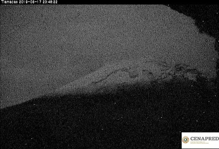
June 22, 2020, 9:07 p.m., Pacific: Lots of incandescense on the Tlamacas webcam at the moment.
And check out this view of Popo during a thunderstorm on the 21st!
El #volcán #Popocatépetl con emisión continúa de gas y cenizas esta tarde noche. Con tormenta eléctrica en su vecindad.
Alerta volcánica en Amarillo Fase2
Junio 21/ 21:15h pic.twitter.com/uBigvPHPu1— Geól. Sergio Almazán (@chematierra) June 22, 2020
https://platform.twitter.com/widgets.js
June 19, 2020, 2:34 p.m., Pacific: The volcano has had some spectacular explosions lately, especially last night. Experts reevaluated its status today and decided to keep the alert level at Yellow Phase 2.
Hoy se reunió el Comité Científico Asesor #CCA del #SINAPROC para evaluar la actividad reciente del volcán #Popocatépetl. 🌋 Se concluyó que su comportamiento está contemplado en el semáforo actual, se mantiene el nivel #AmarilloFase2 del 🚦Alerta Volcánica. pic.twitter.com/QxEOqmwtjd
— ProtecciónCivilSeguridad (@CNPC_MX) June 19, 2020
https://platform.twitter.com/widgets.js
June 5, 2020, 8:46 p.m., Pacific: I think it’s “just” a gassy/sticky packet of magma, as there have a few other explosions since the 31st, producing fairly high ash columns.
Popo may be building domes again.
Here are some nice views of one of last night’s two spectacular explosions:
📹Vídeo | Fast Cam Multiview de la Moderada #Explosión del #Volcán #Popocatépetl 🌋, que tuvo origen este Jueves 04 de Junio del 2020 a las 23:01Hrs (GMT -5).
Vía: @AlMaXx8017.pic.twitter.com/ndhaIRsg9Z
— Webcams de México (@webcamsdemexico) June 5, 2020
https://platform.twitter.com/widgets.js
May 31, 2020, 11:30 a.m., Pacific time: Haven’t updated in a long time because Popocatepetl has stayed in much the same groove. However, Washington VAAC just issued a notice of ash at 22,000 feet, which is a strong emission.
Unfortunately, the upper part of the mountain and the air above it are full of weather clouds on cam. There are no special updates on the CENAPRED site or the Puebla Civil Protection Twitter feed.
The webicorder shows what I think are called “drumbeat” quakes, which signify activity, over the last hour but not the intense tremor seen during some emission periods as noted in previous posts.
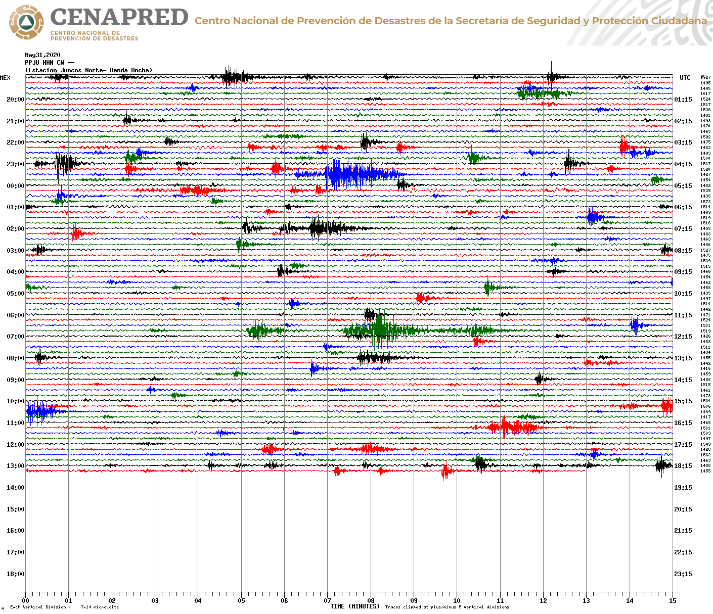
We’ll just have to wait and see what happens next . . .
March 22, 2020, 11:40 a.m., Pacific: The forges are quite active up there at present. There was incandescence visible all night, both in the run-up to midnight and afterwards, with several explosions. Per this morning’s time-lapse video, Popo is continuing that behavior and filling what looks like an otherwise clear sky with thin but extensive ash clouds.
Puebla Civil Protection tweeted last night, after two explosions, that this activity falls into that expected for Yellow Phase 2 alert levels.
Here’s video CENAPRED released this morning of what looks the largest of last night’s explosions:
Sunday Morning Volcano posts (for background)
Useful links
- It’s a challenge to link to CENAPRED’s updates page, but this official site seems reliable, and it’s in English.
- New stream.
- Altzomoni webcam. See this tweet (Spanish) for a picture of where this and other cams, including those linked below, are located relative to the volcano.
- Tlamacas webcam
- Tianguismanalco webcam
- Chipiquixtle
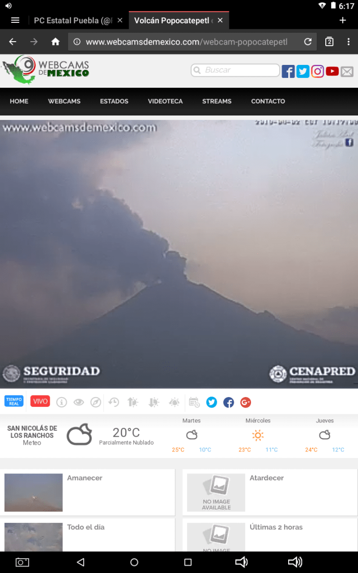
- Webcams de Mexico live cam (Los Ranchos)
- YouTube time-lapse videos from four webcam feeds. (I don’t know who puts these up, but they are wonderful!)
- National Seismological Service webicorders PPIG and CENAPRED’S webicorder (formerly, Chipiquixtle)
- GVP background page.
- Recent Washington VAAC (Volcanic Ash Advisory Center) advisories (you won’t see Popo on this list unless it has had recent activity).
- NOAA/CIMSS volcanic cloud page. I have it set for the last 12 hours of activity. Popo’s typical low-level vulcanian explosions don’t show up, but something bigger will, day or night. Red markings that appear occasionally are technical–for this blog, the link is simply for “an eye in the sky” on the Colossus of Puebla.
- Interactive risk map for Popocatepetl (Spanish, but many technical terms (like “flujos piroclasticos”) are similar to English equivalents (pyroclastic flows); “ceniza” is ash)
Background reads
:
- Popocatepetl: The Smoking Mountain website, apparently from 1994.
- “Challenges in Responding to a Sustained, Continuing Volcanic Crisis: The Case of Popocatépetl Volcano, Mexico, 1994-Present,” easy-to-understand, in-depth scientific background of Popo and its monitoring.
- “Precursors to eruptions at Popocatepetl volcano, Mexico,” Pozzo et al. A little technical, but very easy to read, and it contains an excellent overview of just what Popo has been up to since 1994.
Older blog posts
March 17, 2020, 8:55 p.m., Pacific: Pretty much this recently:
La #CGPCE informa de la actividad del #Popocatépetl en las últimas 24 h, vía #CENAPRED:
▪ 125 exhalaciones
▪ 1000 minutos de tremor
▪ 2 sismos volcanotectónicosEl semáforo🚦de alerta se encuentra en #AmarilloFase2. pic.twitter.com/jLZzuZJ1tq
— PC Estatal Puebla (@PC_Estatal) March 17, 2020
https://platform.twitter.com/widgets.js
A thousand minutes of tremor is the most I’ve seen reported, though I don’t always check the updates every day. Still, per the time-lapse videos, it is at a low level.
That must be tough on nearby communities, but while the magma seems to be rising (you can see incandescence on last night’s post-midnight video) and there are occasional spectacular explosions, this eruption of it is not intense, the way I thought it would be.
In one of the papers I’ve been reading, they say that if Popocatepetl had quickly released as much sulfurous gas as it has over an extended time, its eruption would have been at least as powerful as Pinatubo in 1991.
Popo has had some mighty eruptions in the past, per the GVP, but just now (and since this activity phase began, actually), the “smoking mountain” is living up to its name. Let’s hope it stays that way — smoking, not blasting rock and gas up into the stratosphere!
And give three cheers for open-conduit volcanic systems.
March 14, 2020, 6:09 p.m., Pacific: Popo had some impressive activity this morning, after a restless night. Then it quieted down during the day — handy because weather clouds obscured the summit for most of the day. Now, per the webicorder, activity seems to be picking up a little.
Here are the morning’s time-lapse video and the current webicorder image:

That chunk of heavy activity corresponds to activity shown in the time-lapse videos. I’ll bet it gives volcanologists a lot of detailed information about exactly what’s going on in there.
March 5, 2020, 4:46 p.m., Pacific: Over the last day and a half or so, Popo went from continuous light-ash-content plume to the more baseline “puff/explosion” style, and now it sort of seems like it’s trying to combine the two styles.
Yeah, that’s not very helpful, I know, but I’m not a volcanologist.
Yet this is the first time I’ve seen that wavy “loose perm wave” style tremor on the webicorder combined with spiky tremor:
Chipiquixtle webicorder this afternoon
And here’s the time lapse from noon to 5:59 p.m., local time — you can see that intermittent “puff-gassing combo” I’m talking about. (It’s still going on, by the way.)
None of this rates a status update from the volcanologists, of course, but I wonder what’s up with Don Goyo.

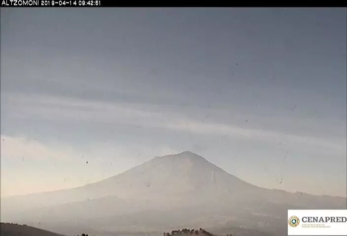
The view from CENAPRED’s Altzomoni cam a little while ago.
March 3, 2020, 3:05 p.m., Pacific: The Colossus of Puebla is still putting out a steady stream of ash/steam/vapor on the webcams, and its current webicorder, while showing a little of the “Loose perm wave” kind of tremor, still contains episodes of the more typical “spiky” kind (not any “punch perm” tremor — these are not official terms, of course [see the February 22nd post]).
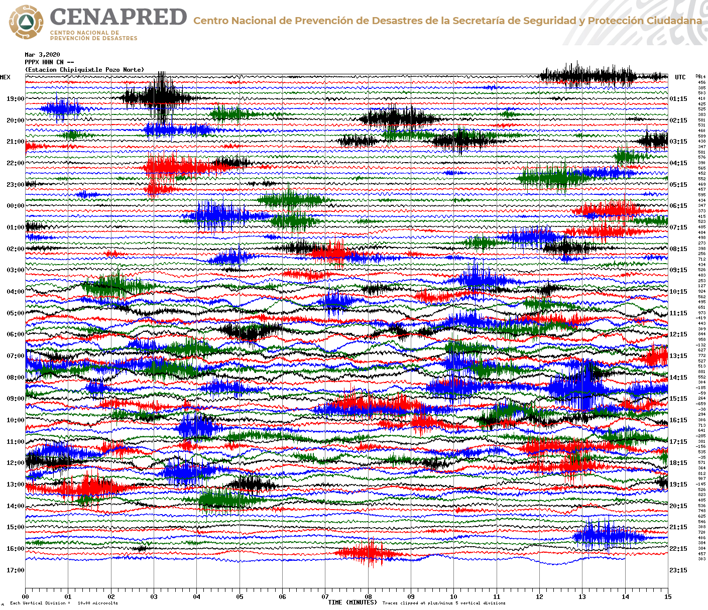
This layperson thinks that Popo did indeed “clear its throat,” as noted in my recent blog posts, and now it is in a type of eruptive mode that’s at least slightly different from the old “Popo puff” style that we’ve seen for so long.
Perhaps the big question is this: what was (and is) going on in its “throat” (i.e., the conduit down to a magma reservoir)?
I’ve begun reading a couple of highly cited papers on Popocatepetl’s “puffs” and its SO2 emission (which apparently is extreme as well as unusual in an eruption where so little magma reaches the surface). It appears that even the boffins aren’t quite sure. There are two different kinds of magma mixing here — dark- and light-colored magma, also known as mafic and felsic or basaltic and andesitic. That complicates the picture, as does the volcano’s “open-system” status: apparently there are a number of hypotheses about how Don Goyo’s magma and gases rise to the surface as they do.
I still am looking for papers that discuss what role water (ground water, meteoritic [rain/snow/etc.], and in the magma and country rocks) may play in all this.
Anyway, the alert is still Yellow Phase 3 and there have been no unusual updates. We’ll just have to wait and see what happens next.
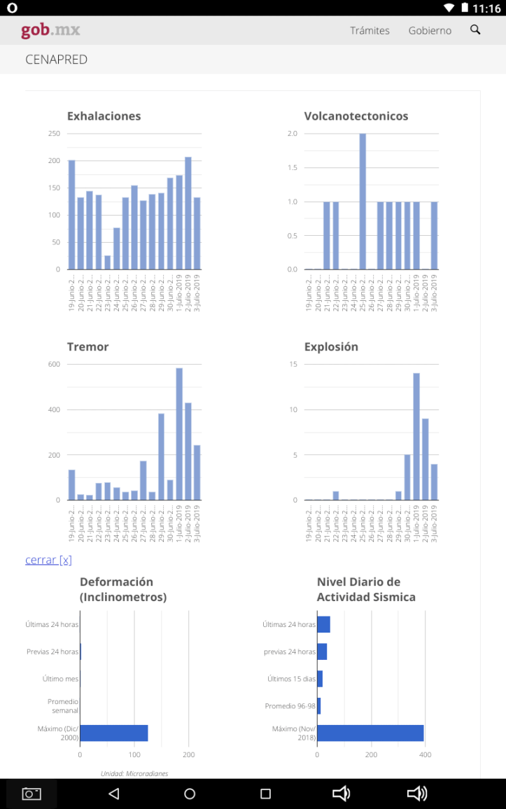
March 2, 2020, 2:08 p.m., Pacific: Per CENAPRED’s update this morning, the volcano started having what they term an exhalation sequence at 17:19 local time that went on for over 940 minutes.
It was productive, but nothing like a Plinian or even sub-Plinian event (to my layperson eyes):
At present, Popo is back to its steady but much lighter release of gas/vapor/ash, per the webcams.
February 27, 2020, 3:13 p.m., Pacific: Popo was active enough over this past weekend that I did a blog post on it for the February 22 Sunday Morning Volcano.
It looked to me a little like clearing its throat, as mentioned in that post. Things then went back to baseline (which is enormously elevated over, say, two years ago, but not as intense as early in this eruption during the 1990s).
There are intermittent explosions, “puffs,” and a fairly constant stream of gases and light amounts of ash, as shown currently in the streaming webcams. I’m no expert, and CENAPRED hasn’t included mention of this in their update, but that light plume seems wider than it was recently (in the past couple of weeks, I’d say). Wonder if the explosions have widened the conduit — when they did the overflight on the 18th (see below), they noted that things look about the same up there.
We’ll just have to wait and see what Don Goyo decides to do next.
February 18, 2020, 6:41 p.m., Pacific: They did an overflight today and report that nothing has changed all that much in the crater. It’s spectacular video, though, and shows that most of the stuff Popo is ejecting falls within the crater (the “tephra” that CENAPRED refers to in its update this afternoon).
There was a “puff” (exalation) while they were up there, too:
Open-conduit volcanoes are amazing!
February 15, 2020, 10:05 a.m., Pacific: Popo has a lot of energy this morning. I’ve been watching it just now through the Tlamacas live stream, and in 20 minutes it has had numerous “puffs.” CENAPRED, in its morning update, calls them a sequence of exhalations. They released this video:
What’s the difference between an exhalation and an explosion?
Popo also had a few explosions overnight, including this awesome one in the late evening:
It’s good that Popocatepetl is an open-conduit system so that energy can be released in such relatively harmless ways.
Watching Popo is addictive any time, but especially when it is so active. This morning, while gazing at it through the Tlamacas cam and sipping morning coffee — yes! — I noticed that there seemed to be two plume sources. The one on the right was faint, but emitting a whitish blue vapor that I’ve read elsewhere indicates high sulfur content. The one much farther to the left was the usual gray/white mixture of vapors and light ash content.
Could be a crater and a fumarole, I suppose, or perhaps a dome up there (though it would have to be very large, given the separation of the two plumes), or two sources. Wish I were a fly on the wall at CENAPRED, just to learn more about the details. But I wouldn’t distract them from their all-important job of helping to protect all of Don Goyo’s human neighbors.
February 13, 2020, 7:22 p.m., Pacific: About an hour after midnight, local time, last night, there was a spectacular explosion, one of 5 that were included in CENAPRED’s update this morning. The bright moonlight makes this video that CENAPRED shared even more awesome:
There apparently was another big explosion around 6 p.m. tonight, local time.
A las 17:59 h se registra una explosión del volcán #Popocatépetl, la columna eruptiva con contenido de ceniza se dispersa al nor-noreste de Puebla.
El Semáforo🚦de Alerta Volcánica se mantiene en #AmarilloFase2 pic.twitter.com/QkzmXUBIep
— PC Estatal Puebla (@PC_Estatal) February 14, 2020
https://platform.twitter.com/widgets.js
Unfortunately, clouds mostly obscured the summit in all but the Chipiquixtle webcam, per the 12:00 to 17:59 video at this time lapse video YouTube site. Per Puebla’s Civil Protection, though, it happened right at 5:59 p.m., which is when the last currently available time-lapse video ends — don’t see it. Hopefully, it will on the next video, which will be uploaded shortly after midnight local time.
Puebla probably got ashed. People must be edgy, since Puebla Civil Protection put out another tweet stating that this activity is within the range expected during the current alert level and warning everybody not to listen to rumors.
It must be difficult to deal with this constant ash emission recently, and those explosions, but y’know, if the large amount of magma scientists reported in 2018 is at the surface now, this is absolutely the best way for it to come out — little by little, over an extended period of time.
Of note, I’ve gained better insight into what might be causing these explosions — I thought it was simply lava domes forming and then exploding, but Tina Neal, of the Hawaiian Volcano Observatory, described another process that can close a conduit, leading to pressure buildup, when she gave a talk recently about the crater lake atop Kilauea volcano.
This discussion starts at around 7:10. As I understand it, there is a lot of silica in any subduction volcano’s magma, like New Zealand’s White Island or Mexico’s Popocatepetl (and unlike Hawaiian volcanoes, which are forming over a hot spot — different geochemistry).
When exposed to a lot of water, that silica polymerizes — gloms together, basically — and plugs the conduit. Gas and steam then have nowhere to go; pressure builds; and BOOM!
The magma can now move up through the conduit again, so things quiet down, until the next silica “lump” blocks it again.
That’s just what I think is going on at Popo right now — I haven’t read anything related to this from experts at this volcano.
February 11, 2020, 12:20 p.m., Pacific: Popo had been just chugging along, but several hours after a couple of explosions night before last, i.e., yesterday during the day, tremor increased and a constant ash emission got underway.
It’s impressive and ongoing:
While this must be a annoying to nearby residents, the ash quantity is light — you can still see a little snow on the upper reaches of the volcano in the Tlamacas cam.
The alert level is unchanged, but Puebla State Civil Protection posted one of their “Don’t listen to rumors” tweets this morning.
We’ll just have to wait and see what happens next.
From CENAPRED, January 26, 2020, update
CENAPRED reports over a thousand minutes of tremor at Popocatepetl during the last 24 hours (up to 10 a.m. local time this morning) — that’s the highest reported number I’ve seen it in the last several years.
There is no deformation shown in the report graphics (left) and this morning, before the clouds began to form, Popo was quiet enough. The air is rather clear — wonder if the ash emission phase is over.
Here’s the CENAPRED streaming link, just in case. The summit is socked in at the moment, but in clear weather you can see it from Tlamacas and Tianguismanalco.
They have taken down the very sensitive public webicorder and replaced it with a much less sensitive one — that’s not new, I just haven’t mentioned it on the blog yet. I suppose it doesn’t matter — the really sensitive one probably contained a wealth of information for volcanologists and seismologists, but to me it just looked like a lot of squiggles. Popo does have a bad case of heartburn.
And, from this morning’s report, that is especially true over the past day!
Update, January 21, 2020, 10:07 a.m., Pacific: Just noticed that CENAPRED now offers a streaming link!
It’s hidden in clouds right now, but the skies were clear before dawn when Popo had yet another spectacular explosion:
https://youtube.com/watch?v=caSnf3mw9So&rel=0
These seem to be coming a bit more frequently. Sigh. Still within Yellow Phase 2 alert level activity, though.
January 12, 2020, 12:18 p.m., Pacific: On the 9th, Popocatepetl had a spectacular eruption at dawn that was captured on a video that drew global attention:
That was the first time I’ve seen incandescence in a blast here during daytime, and I waited to see if the volcano was escalating quickly.
However, it seems to have gone back into the same cycle again — periods of activity, now stronger than ever, alternating with more quiet periods. Volcanologists could describe it more thoroughly; to me, it just looks like these active periods are getting a little stronger. Who knows whether the volcano will slowly crank up into a full-blown continuous eruption over a relatively short term and then settle back down or just keep doing this for, perhaps, decades?
What must be very difficult for everyone in the region, especially when they’re downwind of the vent, is that constant low-level dusting with ash and perhaps also light volcanic gases.
https://youtube.com/watch?v=3Nyda47TM44&rel=0
Update, January 13, 2020, 4:35 p.m., Pacific: No major changes. Just wanted to show what Puebla’s Civil Protection is advising for ash exposure — it’s in Spanish, but with self-explanatory images and video.
Recomendaciones ante la posible caída de #CenizaVolcánica 🌋 #PueblaResiliente || @CorsarioGRD pic.twitter.com/Pnx2sC2zPE
— PC Estatal Puebla (@PC_Estatal) January 13, 2020
https://platform.twitter.com/widgets.js
January 7, 2020, 4:09 p.m., Pacific: No changes; I just wanted to post this beautiful video (they also give today’s CENAPRED update stats). It presents a “magical” combination of geology, weather, and the stars — beautiful!
Reporte #CENAPRED || Actividad del volcán #Popocatépetl en las últimas 24 horas:
🔘 141 exhalaciones
🔘 289 minutos de tremor
🔘 1 sismo volcanotectónico
🔴 El semáforo 🚦 de alerta continúa en #AmarilloFase2. pic.twitter.com/yKhVMDhgBX— PC Estatal Puebla (@PC_Estatal) January 7, 2020
https://platform.twitter.com/widgets.js
December 19, 2019, 3:22 p.m., Pacific: In this layperson’s opinion, Popo has settled down into a more active version of its former habit of “puffing,” only this time, instead of short puffs there are extended periods of venting of water vapor, gas, and small quantities of ash. Each period includes a series of more intense ashy “puffs.” Then things quiet down for several hours until the next event starts.
If that’s how that extra magma is going to come up, well, then, hurray for open-system volcanoes! But it does seem as though there is a bit more ash in each episode as time goes by.
Here’s time-lapse video of the beginning the ongoing episode this morning:
https://youtu.be/MuPf9F2hkZk&rel=0
November 27, 2019, 7:29 p.m., Pacific: I didn’t realize until watching this afternoon’s time-lapse . . .
https://youtu.be/zOHZD0MJEeY&rel=0
. . . that a lot of that ash plume visible on the webcams was from very strong winds. Popo also contributed, of course, but it’s amazing how much loose ash was coming off the upper flanks, particularly later in the afternoon.
November 27, 2019, 2:09 p.m., Pacific: The evacuation drill is going well, per PC Puebla State:
🔴 #Atento ⚠️ #Simulacro #Popocatépetl ⚠️
🚓 Arriba el primer convoy, originario de la Cabecera Municipal de Tochimilco, al #RefugioTemporal ubicado en el Municipio de Izúcar de Matamoros. #PueblaResiliente #CulturaDePrevención pic.twitter.com/s4WG9LlroC
— PC Estatal Puebla (@PC_Estatal) November 27, 2019
https://platform.twitter.com/widgets.js
Meanwhile, Popo all morning has been putting out a light ash plume — it’s actually dusting that one sector rather intensely, an effect I haven’t noticed before:

I don’t know where the towns are that they are drilling (and it’s 24, by the way, not 26 as I mistakenly noted earlier), but overall the strong and steady wind is keeping the ash from spreading out into the entire neighboring zone. That would have been tough on everybody.
They’re drilling today for a Red Phase 1 alert, but the volcanoa actually is still at the same Yellow Phase 2 level.
November 25, 2019, 2:57 p.m., Pacific: Yeah, Puebla (home to over six million people), is getting a lot of ash, though the volcano’s activity is about the same. This was tweeted just a few minutes ago:
Continúan las exhalaciones con contenido de ceniza del volcán #Popocatépetl, la dispersión predomina hacia el Estado de Puebla. Extreme precauciones
🔴🚦 en #AmarilloFase2 #CENAPRED pic.twitter.com/SWsCfiTsF3
— PC Estatal Puebla (@PC_Estatal) November 25, 2019
https://platform.twitter.com/widgets.js
Despite the red dot there, the “traffic signal” is still Yellow, Phase 2.
You can also see the ash in the current Altzomoni webcam:
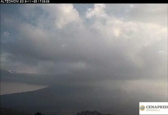
That haze isn’t sand or pollution — it’s powdered rock and glass shards. While this is not heavy, as volcanic ash production goes, the constant low-level emission is very hazardous to people, animals, and perhaps even plants.
November 25, 2019, 11:24 a.m., Pacific: Hmmm . . .
About six hours ago:
#MonitoreoVolcánico A las 02:13 h el gran #Popocatépetl presentó una explosión con lanzamiento de material incandescente. Al momento, continúa la emisión de vapor de agua, gases y ceniza con dispersión al este, es decir, al Estado de Puebla. 🚦 en #AmarilloFase2 #CENAPRED pic.twitter.com/oNzCom0ieg
— PC Estatal Puebla (@PC_Estatal) November 25, 2019
https://platform.twitter.com/widgets.js
An hour after that, basically ‘the activity of Popocatepetl is within that expected for the Yellow Phase 2 alert level; don’t listen to rumors’ — all good, and a message PC Puebla and other experts have repeated many times:
La actividad que ha presentado el #Popocatépetl 🌋 en las últimas horas está contemplada dentro de la etapa #AmarilloFase2 del 🚦 de alerta.
🚫 No hagas caso a rumores, infórmate a través de cuentas oficiales y respeta el radio de seguridad de 12 km. #PueblaResiliente pic.twitter.com/Lp5cotli7e
— PC Estatal Puebla (@PC_Estatal) November 25, 2019
https://platform.twitter.com/widgets.js
Then, a couple hours ago, the usual daily CENAPRED update summary, with a nice video of last night’s big explosion (not the first one that size at the volcano recently):
#CENAPRED || Actividad del volcán #Popocatépetl registrada en las últimas 24 horas:
🌋 142 exhalaciones
🌋 1 explosión moderada
🌋 88 minutos de tremor
🔴 El 🚦 de alerta continúa en #AmarilloFase2. Se exhorta a respetar el área de restricción de 12 km. #PueblaResiliente pic.twitter.com/hHKROe9dM8— PC Estatal Puebla (@PC_Estatal) November 25, 2019
https://platform.twitter.com/widgets.js
All within normal limits, given Popo’s increased activity.
But then, “don’t alarm yourself, BUT . . . ”
#Enteráte El día 27 de noviembre (09:00 h) se llevará a cabo un #Simulacro de "Evacuación por Contingencia del #Popocatépetl", donde participarán las 24 comunidades más cercanas al coloso.
🔴 ¡No te alarmes!
🤝 Juntos fortalecemos la cultura de #Prevención. #PueblaResiliente pic.twitter.com/L18lSG742X
— PC Estatal Puebla (@PC_Estatal) November 25, 2019
https://platform.twitter.com/widgets.js
” . . . at 9 a.m. on Wednesday, we’re going to practice an evacuation of the communities closest to the volcano.”
This came about 40 minutes ago, and about a half-hour after PC Puebla tweeted a video showing the evacuation routes.
I don’t think the authorities are trying to pull a quick one of any sort — my overall impression after watching this, even from a distance, is that the right people, making the right decisions, are in charge here and they’re doing a heckuva good job.
It’s always a little disconcerting, though, to see authorities say “Don’t worry but . . . ” and then see news of an evacuation practice.
Popo has been getting more and more explosive, but not in a drastically changed way. I’m no seismologist but don’t see much of a change on the webicorder (which doesn’t mean much, given my ignorance). I do note that there is more ash in the air — have seen that on the webcams over the last week or so.
They’d raise the alert level, if any bad changes appeared imminent; but I think this practice does reflect some concern that someone has seen about the volcano’s monitoring data. Perhaps there’s a bit more magma coming (a lot more, and we’d be seeing a major event), and they are preparing people for whatever the volcano may do next — very responsible move.
And a heads-up to all of us to keep watching closely!
November 19, 2019, 3:55 p.m., Pacific: About half an hour ago. The webicorder was very active for a few hours leading up to this — the alert level is still yellow, Phase 2.
#Explosión con contenido de ceniza del volcán #Popocatépetl (17:13 h). La columna eruptiva se dispersa al oeste de la entidad. Se exhorta a respetar el radio de seguridad de 12 km. #CENAPRED 🚦 en #AmarilloFase2 pic.twitter.com/1CXWDsvPu5
— PC Estatal Puebla (@PC_Estatal) November 19, 2019
https://platform.twitter.com/widgets.js
As of the time of writing, the webicorder isn’t really settled down yet.
However, per the video (below) that just went up, it was just an explosion, not a continuous venting — the summit has been hidden in clouds for much of the day, but the Chipiquixtle camera (lower right) caught it beautifully!
November 18, 2019, 2:37 p.m., Pacific: At 12:30 local time, CENAPRED issued an update about a constant ash emission. Here it is, just beginning, per Civil Protection, Puebla State:
#Actualización El semáforo 🚦 de alerta volcánica del #Popocatépetl continúa en #AmarilloFase2. https://t.co/0oWHoSI88b
— PC Estatal Puebla (@PC_Estatal) November 18, 2019
https://platform.twitter.com/widgets.js
They warned that several communities would get ashfall, but kept the alert level at Yellow, Phase 2.
Per the webicorder, it looks like Popo is settling down a wee bit now:
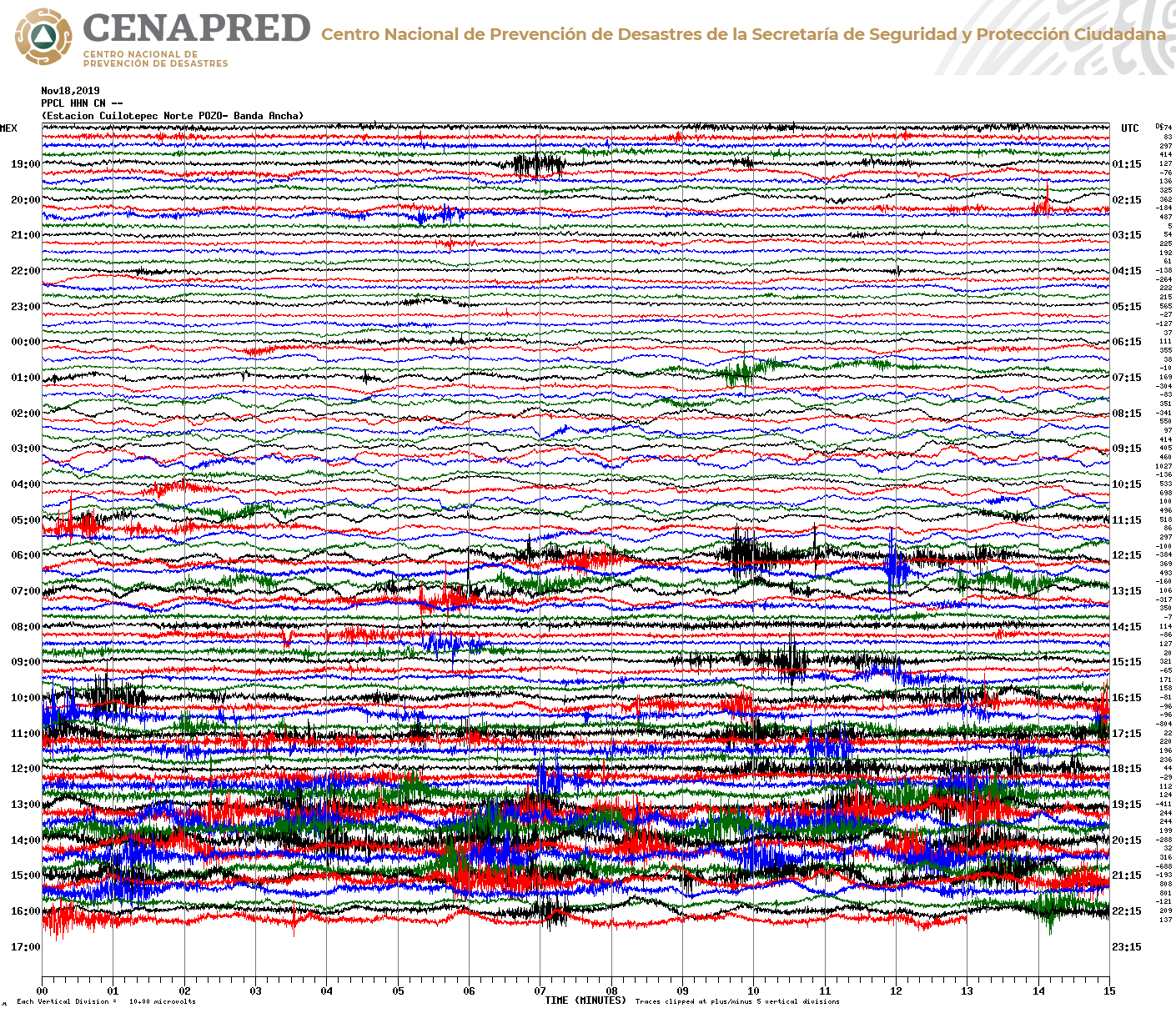
Still, the volcano presents a grand, though rather cloud-wrapped appearance at the moment on the live cam.
November 13, 2019, 3:33 p.m., Pacific: No change from the current increased level of activity; given that the webicorder looks like this for the last few days, though . . .
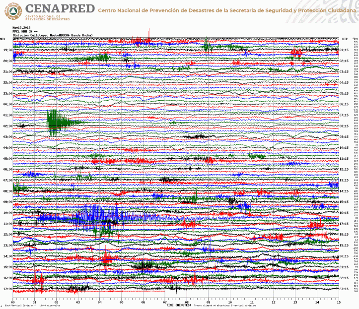
. . . I thought it was worth noting that this morning’s CENAPRED blog had a brief general-interest post (Spanish) on lava flows on Popocatepetl. As far as I know, there aren’t any — the boffins would surely have mentioned if any were observed, other than dome building, which they have mentioned (see below) — but this sort of activity does happen at the volcano. You can see some ancient flows up near the crater — years ago, I mistook them for glaciers!
I’m just wondering if the volcanologists see signs too vague to include in the updates but strong enough to warrant a “heads-up” just so people won’t freak out if sticky molten lava does appear on the webcams some day soon. As they say in the past, it won’t flow fast, but people living nearby will need to take action.
November 8, 2019, 4:40 p.m., Pacific: CENAPRED released video of a November 5th overflight today and included a special warning not to enter the no-go zone, as the volcano’s calm is deceptive and explosions (which have become more frequent) could happen at any time.
They identified the 85th dome of this long-standing eruption, measuring it at 689 x 263 feet; that crater, they say is about 1,148 feet across and some 295 feet deep.
Also, check out this video of strong winds blowing the ash on the flanks — there is quite a bit of it lying loose up there!
November 7, 2019, 11:49 a.m., Pacific: Just followup on the November 3 post. Popo continues to have elevated activity, more explosions (“light” and “moderate”), and lots of tremor, but the alert level remains the same. Just for example, here’s this morning’s update, in brief, via Civil Protection, Puebla, with a brief but spectacular video of a “moderate” explosion:
Actividad del volcán #Popocatépetl de las últimas 24 horas:
⭕ 118 exhalaciones
⭕ 7 explosiones moderadas
⭕ 416 minutos de tremor
🔹️ El semáforo 🚦 de alerta continúa en #AmarilloFase2 #CENAPRED. Se exhorta a respetar el área de restricción de 12 km. pic.twitter.com/xS0lQpJgTT— PC Estatal Puebla (@PC_Estatal) November 7, 2019
https://platform.twitter.com/widgets.js
November 3, 2019, 3:31 p.m., Pacific: The authorities had a meeting on this today. They’ve decided to keep the volcano at Yellow, Phase 2 level (translation per Google Translate and me):
November 03, 14:30 h (November 03, 20:30 GMT)
Today, the Scientific Advisory Committee of the Popocatepetl volcano met to analyze recent activity. It was determined that it has not exceeded the levels observed in recent years. The most likely scenario is that the ash emissions that reach communities near the volcano and further away, such as Mexico City, continue. Eventually, some explosions may occur that do not exceed in magnitude those already observed. These scenarios are contemplated at the Yellow Phase 2 level of the Volcanic Warning Traffic Light.
November 3, 2019, 11:27 a.m., Pacific: This is the first time I’ve seen them report emissions accompanying the tremor:
November 03rd, 11:00 h (November 03rd, 17:00 GMT)
In the last 24 hours, through the monitoring systems of the Popocatepetl volcano, 28 long period events and two explosions (ocurred today at 01:38 and 03:19 h) were identified, but weather conditions prevented visibility.
Aditionally, 780 minutes of tremor were registered in four main episodes. The first one started yesterday at 11:06 and lasted untill 21:30 h, and was accompanied by ash emmissions which were carried to the west and northwest by the prevailing winds (image 1) (image 2). Ashfall was reported in Amecameca, Juchitepec, Ozumba, Tepetlixpa and Atlautla, State of México, in Ayapango and Cuautla, Morelos, and in the the mayoralties of Tlahuac, Tlalpan and Xochimilco in Mexico City.
Two other tremor episodes ocurred from 01:38 to 03:04 and from 04:31 to 05:15. Finally, another one ocurred between 09:15 and 09:45, accompanied by a steam and gases plume (imagen 3) (video 1) (video 2) (video 3).
At the time of this report there is no visibility, but earlier this morning an emission of steam and gases, with north-northwest direction, was observed (imagen 4).
CENAPRED emphasizes that people SHOULD NOT go near the volcano, especially near the crater, due to the hazard caused by ballistic fragments (image 5) and in case of heavy rains leave the bottoms of ravines because of the danger of landslides and debris flows.
The Volcanic Traffic Light Yellow Phase 2.
October 10, 2019, 3:57 p.m., Pacific: No overall change, but at the moment Popo is having a continuous gas emission and has had two impressive explosions over the last 24 hours.
Per Civil Protection, Puebla State, about an hour ago:
Continúan las exhalaciones con contenido de ceniza del volcán #Popocatépetl, la dispersión predomina al oeste-noroeste del Estado. @webcamsdemexico #CENAPRED 🚦 en #AmarilloFase2
⚠️ Se exhorta a la población a NO ACERCARSE al cráter del coloso. pic.twitter.com/Aa3irQoen8
— PC Estatal Puebla (@PC_Estatal) October 10, 2019
https://platform.twitter.com/widgets.js
And here is one of the explosions, per this morning’s CENAPRED update:

September 30, 2019, 1:43 p.m., Pacific: Aaaand, there (probably) went the dome:
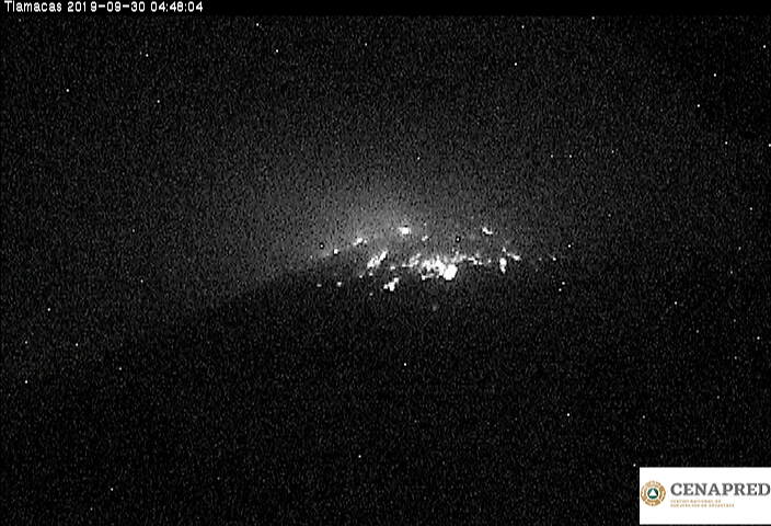
CENAPRED, September 30, 2019, regular update
It was a tiny one, anyway.
September 27, 2019, 7:16 p.m., Pacific: Don Goyo has a new dome, per CENAPRED. They released video this afternoon of an overflight today:
September 14, 2019, 12:22 p.m., Pacific: Here’s something Puebla’s Civil Protection tweeted about five hours ago — it’s the first time I’ve seen volcanologists use webicorders this way (and given the propensity people still have for climbing this volcano, it’s a great idea!)
Por la condición meteorológica en la zona del #Popocatépetl no hay visibilidad por las cámaras de monitoreo. El sismograma del #CENAPRED ha registrado, en las últimas 13 horas, exhalaciones y leves explosiones. No arriesgues tu vida respeta el radio de 12 km 🚦 en #AmarilloFase2 pic.twitter.com/Api1o6sttg
— PC Estatal Puebla (@PC_Estatal) September 14, 2019
https://platform.twitter.com/widgets.js
My translation: “Because of weather conditions around Popocatépetl, it can’t be seen on monitoring cameras. CENAPRED’s seismograph has regiestered, in the last 13 hours, exhalations and small explosions. Don’t risk your life: respect the 12-kilometer radius. Traffic signal alert remains in Yellow Phase 2.”

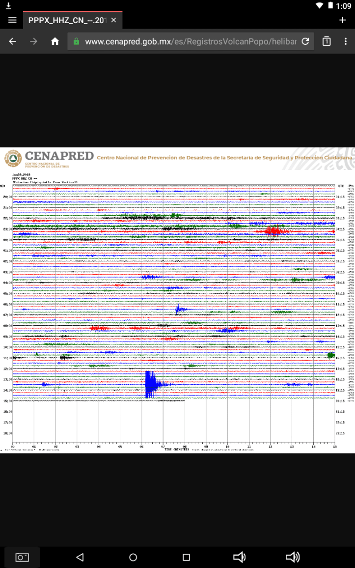
CENAPRED’s webicorder page as of midday, Pacific time, September 14, 2019.
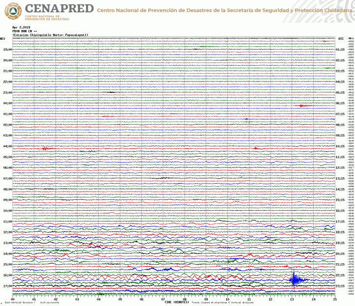
The webicorder has been pretty gnarly lately (current screen-cap, left).
Don Goyo’s external activity is about at the same level as recently, though, so I haven’t been doing any updates here since the September 5th overflight.
September 5, 2019, 5:33 p.m., Pacific: They did an overflight today (two movies included with the update). The crater dimensions remain at 1,148 feet wide by 492 feet deep, and the alert is still Yellow Phase 2.
August 31, 2019, 11:20 a.m., Pacific: No change in alert level, but these vulcanian series are just amazing to someone who has watched a MUCH quieter Popo through the webcam over the past several years. Good thing this is an open-conduit system!
https://youtu.be/XymRE8QvcTM&rel=0
Per CENAPRED’s routine update this morning, several local communities are getting light ashfall.
August 21, 2019, 10:59 a.m., Pacific: Lots of earthquakes reported yesterday and today, in addition to high levels of tremor and explosions. With Don Goyo — a “puffer” and, more importantly, an open system (with little to no deformation before eruptions) — it’s difficult to say what this might mean, but it’s definitely a heads-up:
Today’s report in English from CENAPRED:
August 21, 11:00 h (August 21, 16:00 GMT)
In the last 24 hours through the monitoring systems of the Popocatepetl volcano, 166 exhalations were identified, accompanied by steam, gas and small amounts of ash (image 1). Additionally were recorded nine explosions yesterday at 17:12, 18:05, 18:24,18:39, 19:08, 19:25, 19:31, 19:46 and 20:16 h, also 608 minutes of tremor and nine volcanotectonic earthquakes, recorded yestarday at 10:44 y 19:33 h and today at 04:22, 04:59, 05:19:36, 05:19:45, 05:23, 05:24, 06:08, 06:29, 06:34, 07:41 and 09:10 h, with magnitudes 2.2, 1.8, 2.3, 1.3, 1.9, 2.2, 2.3, 2.2, and 2.1 respectively.

Another heads-up for me — and remember, I’m just a layperson — is that you can’t tell from watching the volcano this morning that it was having a swarm:
https://youtu.be/qRQU_9LPEBY&rel=0
Something is on the move in there that hasn’t had surface expression yet and/or tectonic pressures are doing something.
This is where it’s nice to be a seismologist and know how to read earthquakes (location, “beach balls” for each temblor, etc.). It’s reassuring that there is no special update and they haven’t raised the alert level.
There’s no deformation showing, but I wonder what Popocatepetl will do next. Hopefully, it will just continue on at its present level for the next, oh, millennium or two, until all that magma the scientists described last year is erupted/cools and begins to solidfy.
August 16, 2019, 5:30 p.m., Pacific: A string of what I would call vulcanian activity at Popocatepetl this morning — still Yellow Phase 2 alert level.
#Volcán #Popocatépetl. En las recientes horas la actividad ha estado compuesta de algunas exhalaciones y explosiones a las 10:10, 10:46, 11:27 y 11:53 h, con contenido de ceniza moderada y alturas que van de los 800 a los 2,000 m. Las emisiones se han dispersado al oeste. pic.twitter.com/mhQMrjXfKg
— ProtecciónCivilSeguridad (@CNPC_MX) August 16, 2019
https://platform.twitter.com/widgets.js
August 5, 2019, 11:46 a.m., Pacific: No particular change. I just thought that this is one of the most awesome tweets ever – ah, the joys of watching Popocatepetl!
Reporte del #CENAPRED sobre la actividad del #Popocatépetl en las últimas 24 h:
⭕ 150 exhalaciones
⭕ 1 explosión moderada
⭕ 8 explosiones menores
⭕ 2 sismos volcanotectónicos
⭕ 704 minutos de tremor➡️ El semáforo 🚦 de alerta volcánica continúa en #AmarilloFase2. pic.twitter.com/PRy26C4nYh
— PC Estatal Puebla (@PC_Estatal) August 5, 2019
https://platform.twitter.com/widgets.js
August 2, 2019, 11:41 a.m., Pacific: Yeah, in the time-lapse video from this morning, you can see it was all a sequence of exhalations:
https://youtu.be/UHJBdc2SEkA&rel=0
Still, as a layperson, I’ve got to say that, if this were someone kicking a motorcycle starter instead of a fire mountain fuming away, I’d expect the engine to catch at any moment.
Will see if the analogy holds up.
August 2, 2019, 6:51 a.., Pacific: Aaand the column has stopped. This is probably one of those extended exhalation sequences, and that’s likely what has been going on, rather than a continuous ash plume.
But there was energy behind that column — it wasn’t dispersed soon after leaving the vent, as puffs are.
August 2, 2019, 6:21 a.m., Pacific: The volcano is having a steady emission, per the SNR live cam.
There was an explosion shortly after 5 a.m. local time and apparently the column has been going since:
El volcán #Popocatépetl presentó una explosión a las 05:15 h, expulsó fragmentos incandescentes y una columna eruptiva de ceniza que el viento dispersó al nor-noroeste. Al momento, exhala una fumarola de ceniza hacia al norte.🚦 en #AmarilloFase2 @webcamsdemexico #CENAPRED pic.twitter.com/c8GtENUQj9
— PC Estatal Puebla (@PC_Estatal) August 2, 2019
https://platform.twitter.com/widgets.js
Luckily for both Puebla and Mexico City’s population centers, models predict that the ash will head south today.

July 30, 2019, 6:16 p.m., Pacific: A new term (to me) in the daily update: “sequence of exhalations.” Popo had 424 minutes of it yesterday.
Also, check out the increased level of seismicity over the last 24 hours:

It’s all within Yellow Phase 2 activity, and as with any volcano, this could just settle back down. Or not. My general impression — and remember, I’m just a layperson — is that it’s a significant uptick in overall activity, as though the Colossus of Puebla is slowly but steadily winding up for something, either a long-term spell of increased emissions like what we’re seeing now or a larger eruption.
There certainly appears to be a bigger conduit now!
Civil Protection in Puebla (PC_Estatal) retweeted this about two hours ago — basically, the experts are following it closely:
En el #CENAPRED se lleva a cabo la 62a Reunión Extraordinaria del Comité Científico Asesor del #Volcán #Popocatépetl para analizar y evaluar su actividad más reciente y examinar posibles escenarios. Presidida por la #CNPC y con la participación de la #DGPC. pic.twitter.com/IGZb7tEOcv
— ProtecciónCivilSeguridad (@CNPC_MX) July 30, 2019
https://platform.twitter.com/widgets.js
July 29, 2019, 7:03 a.m., Pacific: Popo is having a restless bout right now, but the activity doesn’t seem to be escalating at the moment.
Check out this new stream I just found! It’s got various webcam views plus live Chipiquixtle and PPIG webicorders:
https://youtu.be/EKXcqvb35-Y&rel=0
July 29, 2019, 9:56 a.m., Pacific: CENAPRED released two videos of the July 27th overflight with this morning’s update (the volcano remains at Yellow Phase 2 alert level).
There’s a more extended view of the emission that happened while the chopper was overhead:
And there was an overview of the crater, which is now huge, compared to the smaller domes and explosion craters seen in overflights earlier this year.
Per the update, they took a lot of thermal and geophysical measurements, too.
Here’s the Civil Protection, Puebla, tweet summarizing the update (scientific terms are very similar in English and Spanish). That moderate explosion was the one that happened around 8 a.m. local time this morning.
Reporte de la actividad del #Popocatépetl (últimas 24h):
⭕ 233 exhalaciones
⭕ 384 minutos de tremor
⭕ 4 explosiones menores
⭕ 1 explosión moderada
El semáforo🚦de alerta se encuentra en #AmarilloFase2. Respeta el radio de seguridad de 12 km. #CENAPRED pic.twitter.com/5rFFxxY8r9— PC Estatal Puebla (@PC_Estatal) July 29, 2019
https://platform.twitter.com/widgets.js
July 28, 2019, 3:11 p.m., Pacific: This isn’t up at the CENAPRED update site yet, but apparently they did another overflight yesterday and confirmed that the dome sighted on the 19th is gone.
Given Popo’s activity yesterday, this was particularly risky. But now they know.
En conjunto con el #CENAPRED de la @CNPC_MX, durante un sobrevuelo de reconocimiento realizado con apoyo de la #GuardiaNacional, corroboramos la destrucción del domo número 83 del volcán #Popocatépetl. #TuSeguridadNuestraMisión pic.twitter.com/DrPnDsQ75g
— Secretaría de Seguridad y Protección Ciudadana (@SSPCMexico) July 28, 2019
https://platform.twitter.com/widgets.js
As I understand it, eruptions at open-conduit systems like this don’t pressurize the whole volcano. The arrival of new magma at the shallow reservoir causes it, or the exsolution of a bunch of gas.
This makes predicting eruptions here especially difficult — quite a problem with so many people living nearby.
July 27, 2019, 12:37 p.m., Pacific: Low-level activity and, per the video below, this morning:
https://youtu.be/iH-rsw3zXa4&rel=0
There is very light ash in those puffs, but Civil Protection in Puebla is using this as a teaching moment:
¿Qué hacer en caso de caída de #CenizaVolcánica 🌋😷?
💧 Humedece un poco la ceniza para no levantar polvo fino.
🧹 Barre los techos, patios y calles.
🚫 No la arrojes a los desagües.
🏠 Permanece en casa el mayor tiempo posible. #PueblaResiliente pic.twitter.com/716cpih6SP— PC Estatal Puebla (@PC_Estatal) July 27, 2019
https://platform.twitter.com/widgets.js
Translation (by me):
- Avoid outdoor activities.
- Protect your eyes, nose, and mouth.
- Close doors and windows.
- Wear a mask when removing ash.
- Avoid driving — the ash reduces visibililty.
- If you have pets, make sure their water and food are uncontaminated.
July 19, 2019, 11:54 a.m., Pacific:
This is an activity increase but it does fall within CENAPRED’s Yellow Phase 2 level of alert.
En las últimas 24 horas, el volcán #Popocatépetl 🌋 presentó:
🔷️ 200 exhalaciones
🔷️ 8 explosiones
🔷️ 412 minutos de tremor
El semáforo 🚦 de alerta continúa en #AmarilloFase2. Fuente #CENAPRED pic.twitter.com/rLOlMP7rw0— PC Estatal Puebla (@PC_Estatal) July 19, 2019
https://platform.twitter.com/widgets.js
July 13, 2019, 11:44 p.m., Pacific: I haven’t been ignoring the Colossus of Puebla — it just keeps doing its (elevated) thing.
Here is a brief summary of this morning’s CENAPRED update and video of one of the recent explosions:
En las últimas 24 horas el #Popocatépetl presentó:
🌋 49 exhalaciones
🌋 647 minutos de tremor
🌋 2 explosiones
El semáforo 🚦 de alerta volcánica continúa en #AmarilloFase2. #CENAPRED pic.twitter.com/y9rIPkanoz— PC Estatal Puebla (@PC_Estatal) July 13, 2019
https://platform.twitter.com/widgets.js
July 6, 2019, 4:16 p.m., Pacific: There was an 890-minute episode of tremor over the last 24 hours, per CENAPRED this morning. No other major changes. The summit is socked in on the webcams now, but it had an impressive “puff” (they do not call it an explosion) around 12:50 p.m.:
A las 12:50 h el volcán #Popocatépetl presentó una exhalación con moderado contenido de ceniza que se dispersa hacia el oeste-suroeste de Puebla. Visto desde San Nicolás de los Ranchos @webcamsdemexico #CENAPRED 🚦 en #AmarilloFase2 pic.twitter.com/lZTJFA7qp4
— PC Estatal Puebla (@PC_Estatal) July 6, 2019
https://platform.twitter.com/widgets.js
July 3, 2019, 11:21 a.m., Pacific: Well, this is encouraging — less deformation, less tremor, and fewer explosions:
July 2, 2019, 3:06 p.m., Pacific: Seismicity and tremor are a little lower over the last 24 hours, per CENAPRED, as well as the number of explosions (just 9 — that’s still way more than the volcano’s typical activity), but there are more “puffs” (exhalations).
Here are a few from this morning:
https://youtu.be/2-3m9YGKEEU&rel=0
The plume from an obscured summit at around 11:44 a.m. was an explosion, per Puebla State Civil Protection’s tweet.
Unfortunately there is stormy weather in the area and the webcams aren’t of much use sometimes.
We’ll just have to wait and see what happens next.
July 1, 2019, 11:39 a.m., Pacific: CENAPRED reports 14 explosions over the last 24 hours. Per the graphic that accompanied this morning’s Spanish-language update, “puffs,” seismicity, and tremor remained high, too.

An encouraging note, perhaps, is that there is no longer that tiny increment in deformation that often showed up over the last month.
We’ll see. (Of note, the volcano is socked in on the webcam currently.)
June 28, 2019, 1:11 p.m., Pacific: Still Yellow, Phase 2, but an explosion last night and some ash chuffin’, too, it looks like. Ashfall, per CENAPRED, was reported in Tetela del Volcán, Ocuituco, and Jiutepec in Morelos State.
Here’s what it looked like on the Chipiquixtle webicorder.
June 22, 2019, 11:14 a.m., Pacific: Per CENAPRED, there was an explosion last night around 9 p.m. local time that showered ash on a few local communities:
See how long and drawn out it is, compared to some of the other recent explosions? It looks like that on the webicorder, too.
And per the routine graphic in today’s update, seismic activity over the last two weeks is at the same level as during 1996-1998, shortly after this active phase began. Or a little higher.

I’m just a layperson, but it all looks to me like Popo is slowly working itself up into a full-blown eruption. When? How big?
Who can know ahead of time? The goal of volcanologists and emergency managers can only be to provide as much warning as possible.
June 21, 2019, 12:45 p.m., Pacific: Still looking majestic as of this moment:
Reporte del #CENAPRED sobre la actividad del #Popocatépetl en las últimas 24 horas:
🔴 144 exhalaciones
🔴 21 minutos de tremor de baja amplitud
🔴 1 sismo volcanotectónicoEl semáforo 🚦 de alerta volcánica continúa en #AmarilloFase2. pic.twitter.com/jbs0SWjaLY
— PC Estatal Puebla (@PC_Estatal) June 21, 2019
https://platform.twitter.com/widgets.js
“Baja” means “low,” so Popo has been relatively quiet, too.
June 18, 2019, 2:30 p.m., Pacific: The webicorder is still fairly quiet, and at the moment Popo is just looking majestic per usual:

There was a video of yesterday’s mid-afternoon explosion linked in this morning’s CENAPRED update:
I wonder if these explosions are going to become as common as Don Goyo’s earlier “puffs”; hope not, because there’s more energy here and something might give way, it seems to this layperson.
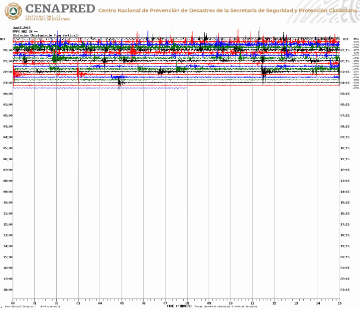
June 17, 2019, 9:44 p.m., Pacific: Things are a little more quiet on the Chipiquixtle webicorder now . . .
. . . and the volcano is visible on the webcams, snow-covered despite the explosions earlier today. Moonlight filtered through clouds gives it a sullen look, though.
June 17, 2019, 5:38 p.m., Pacific: Popo has had an explosive afternoon:
A few hours later came a train of exhalations. This is all within Yellow Phase 2 activity, but it’s leaving its mark on the neighborhood.
Se registra caída de #CenizaVolcánica en el municipio de Santa Clara Ocoyucan. 🚦 en #AmarilloFase2 pic.twitter.com/chnvH0GEgW
— PC Estatal Puebla (@PC_Estatal) June 17, 2019
https://platform.twitter.com/widgets.js
Here’s Google translation of the 1 p.m. update CENAPRED did in Spanish:
At 12:40 a blast was registered whose height reached approximately 8 km, with moderate ash content that the winds scatter to the southwest . . .
The populations of possible fall of ash would be, of the state of Morelos in the municipalities, Tetela del Volcán, Ocuituco, Yecapixtla, Zacualpan, Temoac and Atlatlahucan, of the Edo. from Mexico in Ecatzingo, Atlautla, Ozumba and Tepetlixpa, and from the state of Puebla in San Nicolás de los Ranchos, Nealtican, Tianguismanalco, San Jerónimo Tecuanipan, San Gregorio Atzompa, San Andrés Cholula, San Pedro Cholula, San Isabel Cholula and Puebla.
On further exploration, I also see the Colossus of Puebla greeted the Sun this morning with an explosion:
https://youtu.be/YFwbUK6eXGE&rel=0
The time-lapse view of the mid-day blast isn’t quite as clear as the one from CENAPRED:
https://youtu.be/f73yl8isaHI&rel=0
The summit is socked in on the webcam at present but the Chipiquixtle webicorder shows that restlessness continues.
June 13, 2019, 12:39 p.m., Pacific: They did an overflight on the 11th and found no evidence of a dome. So, whatever is causing the explosions now must be either lava/ground water interactions or buildup of “gassy” magma.
The link to overflight video, given in the CENAPRED report, gets a 404 NOT FOUND message, but a number of people have put it up on YouTube, for example, this one. Nice views of the ashed-over summit flank. You can’t see the summit crater well because of the fumes, but they estimate it’s 350 meters in diameter.
June 8, 2019, 8:47 a.m., Pacific: This is intriguing:

Yet there is no mention of an explosion in this morning’s CENAPRED update. Unfortunately, Popo was socked in early last evening, per the relevant time-lapse video, but when things finally cleared I saw no incandescence.
This morning, there’s a bit of ash on the snow-covered summit, but it could have come from this (tweeted about six hours ago):
El #Popocatépetl ha presentado en las últimas horas exhalaciones de vapor de agua, gases y ligero contenido de ceniza; el viento es un poco variable para la dispersión de partículas. 🚦 en #AmarilloFase2 @webcamsdemexico #CENAPRED pic.twitter.com/NfbCmTWaTB
— PC Estatal Puebla (@PC_Estatal) June 8, 2019
https://platform.twitter.com/widgets.js
Since the weather did clear around that time, per the video, though Popo was apparently producing quite a fume, too, I wonder if it might be a signature of atmospheric turbulence.
Anyway, here’s the video:
https://youtu.be/-Nrv8t28-vs&rel=0
June 5, 2019, 10:35 a.m., Pacific: Tremor and seismic activity are still up, but the deformation is down a bit, per the graph issued with today’s CENAPRED report.
Of note, I accidentally cut off the labels for the top two graphs: that’s exhalations on the top left (Popo “puffs,” basically) and volcanotectonic earthquakes on the top right:
June 3, 2019, 10:01 a.m., Pacific: Since the last blog post, Popo has carried on at its typical recent level, but it does seem to be ramping up a little bit — still in Yellow Phase 2 alert level, though.
Here are this morning’s data as shared in the CENAPRED update:
The summit has been socked in with weather lately, but the Chipiquixtle/Canario webcam caught good shots of explosions this morning, despite the sun glare:
Per Cenapred, ashfall is possible in Ecatzingo and Atlautla, Estado de México [Mexico City and environs, basically]; Ayala, Cuautla, Jantetelco, Jonacatepec, Ocuituco, Temoac, Tetela del volcán, Yecapixtla and Zacualpan, Estado de Morelos; and Acteopan, Atzizihuacan, Cohuean and Tochimilco ,Estado de Puebla.
That’s on both sides of the volcanic range — there must not be strong atmospheric steering currents this morning.
May 23, 2019, 7:30 a.m., Pacific: A big explosion last night around 7:10 p.m. (19:10) local time:
https://youtu.be/SLhnph6bt4s&rel=0
CENAPRED issued two web updates last night (Spanish-language site only). Via Google Translate:
Update May 22, 9:00 p.m. (May 23, 02:00 GMT)
At the time of this update it is reported that the emission of ash and gases that remained after the explosion recorded at 7:10 p.m. has ended. The total duration of the event was 44 minutes. The seismic activity returns to previous levels (image 4). So far there is no report of ash fall.
This type of activity is contemplated in the Yellow Phase 2 Volcanic Alert Traffic Light, any change will be reported in a timely manner.
Update May 22, 7:50 pm (May 23, 00:50 GMT)
At 19:10 an explosion was recorded accompanied by volcanic gases and moderate ash content, whose height reached 3.5 km above the crater. Initially, it was dispersed towards the southwest (video 4) and as it was reaching altitude it changed the direction toward the northeast (video 5) (video 6), so it is probable the fall of ash the municipalities of Atlautla, Ecatzingo, Ozumba, Tepetlixpa , belonging to the State of Mexico; Atlatlahucan, Cuautla, Ocuituco, Tetela del Volcán, Tlayacapan, Totolapan, Yautepec and Yecapixtla, in the state of Morelos. .
At the time of this update, the continuous emission of gases and ash that are scattered to the southwest and whose height does not exceed 500 m are still observed. .
This type of activity is contemplated in the Yellow Phase 2 Volcanic Alert Traffic Light, any change will be reported in a timely manner.
May 16, 2019, 2:04 p.m., Pacific: Popo had a couple of explosions. Per the last overflight, there was no dome seen on May 8th, so I’m not sure what’s causing these. The alert level remains at Yellow Phase 2.
May 9, 2019, 2:42 p.m., Pacific: They did an overflight yesterday, per this morning’s update. Video isn’t available yet, but here’s one of the gorgeous pictures CENAPRED shared:

May 7, 2019, 1:57 p.m., Pacific: They lowered the alert level back to Yellow Phase 2 today!
April 29, 2019, 2:12 p.m., Pacific: Correct me if I’m wrong, but in the following video, the incandescence goes out . . .
https://youtu.be/BA4o5q0xchI&rel=0
. . . around the time that the uppermost episode of tremor stops on this page of the Chipiquixtle (Canario) webicorder:

I think it’s a valid correlation, not merely the summit being concealed by clouds (as it is at the time of writing). You can still see a moving plume in the darkness on that video.
There’s no special meaning to this – a layperson just enjoys being able to spot a connection between two sources of scientific information made available to the public. (G)
The volcanologists, of course, see much more in both videos and webicorders.
But it does raise again one of the most interesting science questions I’ve ever come across: why do volcanoes stop their activity?
In this case, what snuffed out the incandescence?
Just for the record, did a Sunday Morning Volcano post yesterday on Popo, and it includes the most recent overflight video, done last Friday (April 26th). CENAPRED reported that they did not observe a dome during that flight.
After the recent big explosion (see posts further down on this page), the volcano seems to have a different (and less explosive) style. If it must remain active, hope this continues to be the case!
One thing I noted just now, after rewatching the overflight video, is that the fumaroles are back closer to the middle of the crater. That big “hole” shown in the March 30th overflight soon after the explosion, was very close to the northeast crater rim.
Whatever is going on at Don Goyo’s summit crater takes us way beyond the simple model of rising underground magma going up a conduit and erupting in the hole at the top of the volcano as lava!
April 14, 2019, 12:48 p.m., Pacific: Now apparently Don Goyo is switching back over to steam — the first tell-tale white clouds began rising from the crater on the live cam a few minutes ago about three hours ago.
#AlMomento #CENAPRED informa: A partir de las 12:02 h, el #Popocatépetl presentó una emisión continua de vapor de agua, gas y bajo contenido de ceniza que el viento dispersa en dirección noreste. Posible caída de ceniza en #Puebla y con menor probabilidad en #Tlaxcala. pic.twitter.com/Z0odOiYJ2V
— ProtecciónCivilSeguridad (@CNPC_MX) April 14, 2019
https://platform.twitter.com/widgets.js
As you can see from a webcam screen capture earlier this morning, that previous low-level but constant ash emission was light but really hazed up the air. This is actually good for vegetation and soil nearby, but it must be awfully hard to live with day in and day out.
April 12, 2019, 8:46 a.m., Pacific: Another ash emission began yesterday morning, per CENAPRED.
At the time of writing, there is still light ash rising from the crater, and tremor showing on the Chipiquixtle monitor.
Here is video from an overflight they did on the 8th:
April 8, 2019, 11:23 a.m., Pacific: Don Goyo has been rather well behaved lately. Good! It continues to have a low-level emission of gas, vapor, and ashes, as well as VT earthquakes and some tremor, though.
April 4, 2019, 7:51 a.m., Pacific: Per the webicorder and on cams currently, it looks pretty much back to recent background levels of activity in terms of there being a gas/vapor plume, but Popo does seem to be starting to put out a lot more steam (white “cauliflower” clouds, indicating high temperature and convection).

Gonna go out on the prognostication bridge a bit and suggest that this may be the preliminary sign of another ash emission eventually. When? Some time today or overnight.
Will see how that “forecast” goes. I’m basing it on the incredibly intense steam emissions — much more than Don Goyo is showing at the moment — that occurred just before and along with the recent ash emission.
Where does all the water come from? Probably from the magma, though I haven’t read that anywhere. Where else could such quantities of water come from?
The H2O in those white clouds is probably Pacific Ocean water that percolated through some spreading center at the edge of the Cocos Plate (which is the one subducting down into the mantle miles below this part of Mexico), got trapped in the hot rock at the spreading center there a long time ago, and after millions of years of trundling across the sea floor in solid rock, and getting subducted off the Mexican coast, now has been released as the rock melted and just today, right before our eyes, is reaching the surface again.
Where it will eventually rain out and start its journey through the hydrologic cycle all over again.
Overall, I hope this activity today means that Popo will now continue in what the UNAM geophysicists proposed as their first scenario — same level of activity, that is, but without the lava domes. We’ll see.
Follow-up, April 5, 2019, 7:12 p.m., Pacific: Well, I’m batting a thousand with my predictions. 🙂 There was that increase in steaming, as you’ll see in the first time-lapse video below, aaaaand — that was it.
Then the weather became the star performer, leaving the Colossus of Puebla draped in snow, as you can see in the second video!
This volcano is scary, and second only to Vesuvius in the threat it poses to humanity, but it is so majestic and mysterious!
https://youtu.be/ECWGFEpZuV4&rel=0
https://youtu.be/mtSKVM37Spw&rel=0
April 3, 2019, 5:21 p.m., Pacific: Just a check-in; I don’t see an ash emission on the cams, but the webicorder has some “squigglyness.”
A check of the news shows that some flights between Puebla and Cancun were canceled this morning because of ash, and Aeromexico delayed a flight to Monterrey, but otherwise no reported changes.
No mention of ash fall.
This is an excerpt typical of the outreach that volcanologists and other authorities are doing, per several news articles. It’s via Google Translate (original here):
David León stressed that the Popocatépetl volcano has not had more activity, but a different dynamic.
That is to say, a routine that went from the formation of domes and the destruction of domes to explosions without domes “, explained David León.
The federal official said that this change of traffic light allowed to strengthen the preventive work that was done. He specified that in the first 15 kilometers near the volcano’s slopes there are 13 municipalities, with a total of 45 thousand inhabitants, so a digital platform was created for media and citizens to see the state in which the 41 exit routes are located , through a video.
It has been a great work of prevention. What I can tell you is that the routes are passable, of course there are areas of opportunity, there are narrow roads, there are bridges that have to be repaired, but today they are operational.”
April 3, 2019, 8:06 a.m., Pacific: Well, this sums up the situation in a tweet, confirmed by a look at the cams and webicorders, which are accessible now:
Ayer el #Popocatépetl a las 16:35 h inició una emisión de vapor, gas y pequeñas cantidades de ceniza. Con algunas fluctuaciones, la emisión persiste hasta ahora. La columna se ha mantenido entre 400 y 800 m, con dirección inicial al este. El🚦de alerta permanece en #AmarilloFase3 pic.twitter.com/WtwEdC1ueL
— ProtecciónCivilSeguridad (@CNPC_MX) April 3, 2019
https://platform.twitter.com/widgets.js
My translation: “Yesterday Popocatepetl, at 16:36 h, began an emission of vapor, gas, and small amounts of ash. With some fluctuations, the emission persists now. The column has remained between 400 and 800 meters high, with an initial direction towards the east. The alert remains Yellow Fase 3.”
Here’s what those fluctuations (presumably gas driven) look like on the Chipiquixtle webicorder:

There must be ash fall, but I haven’t found any mentions of it online yet, other than an image on Twitter that I think I saw in an earlier (and much smaller) episode last year.
Apart from this ongoing and, fortunately, low-level episode, here’s a news story, via Google Translate, on how the authorities are responding to the recent uptick in activity.
April 2, 2019, 10:17 p.m., Pacific: Washington VAAC issued a new ash advisory a little less than 2 hours ago.
I can get back into the webicorder site now — that second problem, after the blockage was removed, was probably from so many people trying to get in at once.
April 2, 2019, 9:47 p.m., Pacific: Access to cams and webicorders just came back! The cams are dark (no incandescence, and probably a lot of ash in the area, too); the webicorder is as tweeted in part below. Here is the whole episode on the Chipiquixtle webicorder, and it is still ongoing but diminishing at the moment:

That is a relatively small signal, in this layperson’s view, which is reassuring at a time when the volcano changes its behavior just before darkness falls.
I’m of two minds about the access blockage, which presumably was done intentionally by the government. On the one hand, you’ve got millions of people and you don’t want to alarm them or put out information that can be misinterpreted; also, you’ve got millions of people with Internet access who can crash your networks that must stay open during a volcanic event like this. And you don’t want people looking at their phones if you must call an evacuation; you want them alert and thinking, ready to move as instructed.
On the other hand, as noted above, it’s reassuring to see just how small that signal really is. Even if it had changed, there would still be that trust in government information if the blockage hadn’t happened. Something was lost there, it’s true.
But I don’t know what I would have done, if it had been up to me.
Another one of the complexities of managing a volcano crisis in this high-tech era.
10:05 p.m., Pacific: Nope; the Chipiquixtle webicorder page has switched over to the CENAPRED Popocatepetl blog (with no update beyond this morning’s daily report) and the cams won’t load again.
Well, hopefully Don Goyo will just settle down and the people watching him can work it out overnight. As mentioned below, I do wonder if this emission has further opened whatever pathway cleared after last week’s two explosions. There will be more heard from the volcano over coming days and weeks . . .
April 2, 2019, 9:05 p.m., Pacific: A second-hand look at the Chipiquixtle webicorder. From a tweet from Volcan Popocatepetl (WebcamsdeMexico, I think), it sounds like the public access to cams has been blocked, too.
Thanks to those sharing these images on social media!
Actualización. #CENAPRED comparte el sismograma de las 20:45 de la estación Chipiquixtle del volcán Popocatépetl. Aún se registra señal asociada a la emisión de gases y ceniza con tendencia a disminuir. El Semáforo de Alerta Volcánica Permanece en #AmarilloFase3 pic.twitter.com/DWMQm4RqHL
— Enrique Guevara (@Enrique_gueor) April 3, 2019
https://platform.twitter.com/widgets.js
Note that he points out that the signal is trending downward in intensity. Time will tell if that’s heading for a pause or an end of this particular episode.
By the way, the Sentinel satellite got an overhead view of the explosion on March 28th:

Those two explosions last week must have opened up some pathway. I wonder how much farther it’s opening up with this emission.
April 2, 2019, 7:55 p.m., Pacific: Latest cam images from Tlamacas, per Civil Protection:
#Actualización: #CENAPRED comparte video de la actividad del #Popocatépetl de 19 a 20 h. Se muestra la emisión de gases y contenido de ceniza. El🚦de alerta permanece en #AmarilloFase3. Se exhorta a no acercarse al volcán. pic.twitter.com/A8j3RAqz6G
— ProtecciónCivilSeguridad (@CNPC_MX) April 3, 2019
https://platform.twitter.com/widgets.js
It’s weird — no incandescence. Where’s the magma? Probably in the conduit, though at some depth as there’s no glow on that column at all.
By the way, UNAM/CENAPRED had a press conference this morning (summary here, in Spanish); lots of steam followed by a continuous low-level ash emission was not among the three scenarios offered.
It’s really, really hard to predict volcanic activity, even after 24-plus years of eruption.
Let’s be grateful that the conduit obviously is still open. Pressurization for days to weeks, followed by a big blast, doesn’t seem imminent, at least at the moment; the problem would be if the rising magma stalled in the conduit and formed a plug.
April 2, 2019, 6:45 p.m., Pacific: It’s a continuous emission and is ongoing, but quite light thus far, per Civil Protection, with no reports of ashfall yet:
#AlMomento: #CENAPRED informa que la emisión que inició a las 16:35 h en el #Popocatépetl continúa. Inicialmente dirección al Este, posteriormente al Sur. No se reporta caída de ceniza. El🚦de alerta permanece en #AmarilloFase3. Se exhorta a no acercarse al volcán. pic.twitter.com/NnALYuEOar
— ProtecciónCivilSeguridad (@CNPC_MX) April 3, 2019
https://platform.twitter.com/widgets.js
Predicted ashfall track is east to northeast.
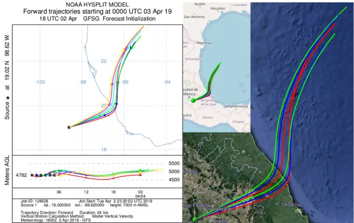
Latest VAAC advisories here.
April 2, 2019, 6:19 p.m. Pacific: I can’t get into the Chipquixtle webicorder site, nor the webcams (and the time-lapse YouTube video that usually goes to 18:59 stopped today at 15:59, so there probably is a problem on CENAPRED’s end).
However, via the live cam, Popo is puffing . . .
. . . and Civil Protection in Puebla tweeted, about an hour ago, a warning that some communities nearby might see some ash:
#Actualización: Por la emisión de gases y cenizas en el #Popocatépetl, puede esperarse ligera #CaídaDeCeniza en los siguientes municipios: San Baltazar Atlimeyaya, San Nicolás de los Ranchos, Atlixco, Santa Isabel Cholula, San Jerónimo Tecuanipan, Nealtican y San Pedro Cholula. pic.twitter.com/WcjHHyw5xc
— ProtecciónCivilSeguridad (@CNPC_MX) April 2, 2019
https://platform.twitter.com/widgets.js
March 31, 2019, 10:36 p.m., Pacific: Overflight yesterday; CENAPRED did an extra update tonight and released this video. The alert status hasn’t changed, but that’s an unusual place to have an explosion crater, on the side, not in the bottom of the summit crater, IMO.
Not sure, but I think that crater wall is east, on the Puebla side. Now I understand the uptick in Puebla Civil Protection tweets about clearing evacuation routes:
Por instrucciones de @GuillermoPaP, luego de acuerdo con el secretario @Fer_Manzanilla de @SGGPuebla y siguiendo los protocolos de Protección Civil Estatal se intensifica la revisión de las rutas de evacuación de localidades cercanas al #Popocatépetl. pic.twitter.com/2iqTVG6cP2
— PC Estatal Puebla (@PC_Estatal) April 1, 2019
https://platform.twitter.com/widgets.js
March 30, 2019, 3:35 p.m., Pacific: All fairly quiet today thus far, but some nice strombolian (gas-driven small explosions and fountaining) activity last night:
March 31, 2019, 7:48 a.m., Pacific: Just one example of the world-class volcano preparedness that Mexico’s governmental and academic authorities are practicing in this unique emergency – shelters are ready for people living near the volcano in Puebla just in case (other announcements I’ve seen have reported other shelter readiness, too).
In addition to this, there are constant checks and re-checks of evacuation routes, and other things as well. Volanologists speak calmly and share everything they know about the volcano’s current state.
This is how you keep a population at risk calm and ready for anything. In a way, it is a sort of “war of nerves” between humanity and the volcano, and the volcano is NOT winning.
El gobierno del estado de Puebla tiene habilitados 205 refugios temporales para albergar a los habitantes de comunidades cercanas al #Popocatépetl en caso de una contingencia. pic.twitter.com/5DCindlNB9
— PC Estatal Puebla (@PC_Estatal) March 31, 2019
https://platform.twitter.com/widgets.js
March 29, 2019, 12:38 p.m.: Not surprisingly, after that explosion, they’ve raised the alert this morning to Yellow, Phase 3.
Addendum: Also, Don Goyo had another big explosion last night around 8 p.m. local time:
https://youtu.be/U5uPWc7ekyI&rel=0
Here’s a good article (Spanish) on the recent events.
March 27, 2019, 11:58 a.m., Pacific: It was the explosion, per CENAPRED this morning:
March 27, 11:00 h (March 27, 17:00 GMT)
In the last 24 hours, through the Popocatepetl volcano monitoring systems, 200 exhalations were identified, accompanied by steam and gas, and a few exhalations with a slight amounts of ash Morelos . . . There was also an explosion yesterday at 19:23 h, which generated a 3 km column and moved northeast. The explosion released fragments up to 2 km on the slopes and caused fires in the area of pastures around the volcano that continue to the north and east. Derived from the explosion, ash fall was reported in Santa Cruz, Atlixco, San Pedro, San Andrés y Santa Isabel Cholula y San Pedro Benito Juárez, it was also reported in municipalities of Puebla and Hueyapan and Tetela del Volcán and municipalities of Morelo . . .
Oh yeah.
March 26, 2019, 6:55 p.m., Pacific: A big explosion reported by CENAPRED; it happened about an hour and a half ago. Not sure what’s going on now, per the webcam images:

However, about 20 minutes ago, Puebla’s Civil Protection tweeted that the alert level is still yellow, phase 2.
7:11 p.m., Pacific: Had a little trouble getting into the live cam, perhaps because half the world was trying to view it, too, but once in it shows basically just Popo’s typical incandescence these days.
The Chipiquixtle webicorder is not scary, either.
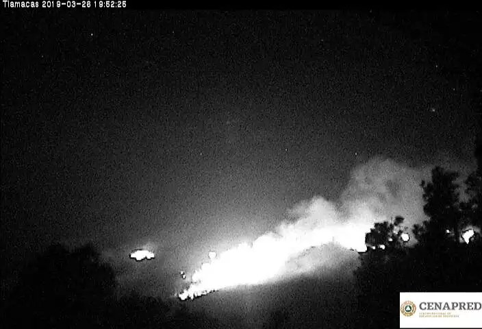
Having been fooled by a forest fire on the volcano’s flanks years ago, I’m thinking that explosion ignited forests up there. The wind is really bad in the area, and has been for a couple of days, at least: fire could be a terrible problem, too. No word yet. Will keep an eye out for news.
7:21 p.m., Pacific: Yep. Forest fires. And this tweet is 4 hours old, so it wasn’t the explosion. Sigh.
Incendios 😞 pic.twitter.com/kSExKwjvNV
— Volcán Popocatépetl (@Popocatepetl_MX) March 26, 2019
https://platform.twitter.com/widgets.js
Don’t know when they began, or how, but the air around the volcano showed no smoke when I last checked the webcams — about 6 hours ago.
March 21, 2019, 12:13 p.m., Pacific: Some young people climbed up to the crater earlier this week. Don Goyo did not kill them. Of course I’m not going to link to their video of the exploit, though I appreciate the human success of the climb and the spirit in which it was made.
It was still stupid.
I’ve seen other videos; one from years ago, when the volcano was quieter but still active. No point in linking that one, nor to the one made by some people who did get killed up there.
I can’t, in all honesty, suggest these people are possible Darwin Award candidates – humanity is around today because we do these types of things, especially our young adults. But I cannot praise it, because I would feel like an accomplice to the inevitable deaths and maimings.
CENAPRED knows who they are, per the news story linked above (in English, via Google Translate). Besides counseling, I would suggest that they, and others who might be inclined to do something similar, be required to read Surviving Galeras, by Dr. Stanley Williams. It’s an account of a really bad day at another Latin American volcano, when volcanologists were caught in the crater during an explosion.
The Mexican climbers should read it as part of the transition to adulthood.
Yes, we admire your spirit. But there is a future, and it depends on what you do now, during a time when it seems as though you are both invulnerable and immortal.
We would like to share that future with you. Please join us there, as strong and healthy as you possibly be.
Please. Respect the safety radius.
March 15, 2019, 1:25 p.m., Pacific: A summary of this morning’s CENAPRED report:
Resumen #Popocatépetl últimas 24 h (15-Mar-2019)
▪️ 136 exhalaciones
▪️ 90 minutos de tremor
▪️ 1 explosiónEl🚦de alerta permanece en #AmarilloFase2. Se exhorta a NO ACERCARSE al volcán y sobre todo al cráter
Consulta el reporte del #CENAPRED:https://t.co/W9duz1qSqP pic.twitter.com/BujdRUA6NL
— Enrique Guevara (@Enrique_gueor) March 15, 2019
https://platform.twitter.com/widgets.js
It was quite an explosion:
March 8, 2019, 6:29 p.m., Pacific: They went up yesterday to see how the lava dome was doing, but degassing was so heavy that they couldn’t get much data (it’s not on the film, but there was an explosion up there during the overflight; apparently it didn’t affect the equipment or team, fortunately — at least there was no mention of effects):
Also, this afternoon, CENAPRED issued an update:
At 15:24 hours an explosion occurred which produced a column with low ash content, which initially reached a height of 1500 m above the crater. Later, when being displaced by winds with southwest direction, the emission arrived approximately at 3000 m . . . It is possible that in the next few hours there will be a slight drop of ash in communities of this sector as Tochimilco, San Francisco Huilango and Huaquechula.
The alert level is still Yellow, Phase 2. I can’t find any news reports of ash online on a quick search.
February 23, 2019, 11:42 a.m., Pacific: Less tremor (211 minutes is a lot, but less than earlier in the week) but way more LP quakes reported by CENAPRED this morning: 62.
At the moment, Popo is pouring out a big steam plume.
February 22, 2019, 2:39 p.m., Pacific: Per CENAPRED this morning, 19 long-period quakes over the preceding 24 hours and 905 minutes of low- to medium-amplitude tremor.
Here’s an overview of Chipquixtle seismicity since the 19th:

February 21, 2019, 11:34 a.m., Pacific: 1432 minutes of low-amplitude tremor overnight, per this morning’s CENAPRED update, and 10 long-period quakes over the last 24 hours. Per the webcams, the volcano continues to simmer.
February 20, 2019, 3:02 p.m., Pacific: A new overflight this week:
That crater looks larger (they say the dome is 200 m [almost 700 feet] across), but it’s good to see that the surface is nowhere near the crater-wall rim (which could lead to pyroclastic flows down the volcano’s flanks).
Also, per CENAPRED today (emphasis and link added):
In the last 24 hours, through the Popocatepetl volcano monitoring systems registered 11 long period seismic events with light emission of steam and gas . . . and two explosions at 02:10h and 04:07h . . .
Additionally, it was registered a volcanotectonic earthquake, yesterday at 21:02h, with magnitude 1.9. Also were detected 1424 minutes of low and medium amplitude tremor.
The Chipiquixtle webicorder shows that the tremor slowly waxed, reached its peak for a while, and has since slowly waned since:


February 18, 2019, 8:50 a.m. Pacific: Per the time-lapse videos, it looks to this layperson as though Don Goyo went back into its former phase overnight. The steady stream of ash/vapor plume–shown stunningly under bright moonlight!–transitioned into the former very light plume with intermittent “puffs” that we’ve seen in recent months (once again, even that is much more activity than I saw through the webcams years ago).
But that didn’t last long; there was more incandescence and then explosions instead of puffs.
#CENAPRED: actividad reciente del #Popocatépetl con emisión de gases, ligeras cantidades de ceniza y algunos fragmentos incandescentes.
El🚦de alerta volcánica permanece en #AmarilloFase2. pic.twitter.com/16bqn2lDbd
— Enrique Guevara (@Enrique_gueor) February 18, 2019
https://platform.twitter.com/widgets.js
That style kept on through 6 a.m. local time, the last video uploaded thus far today.
I’d say that transition point coincided with a change on the Chipiquixtle webicorder:

The conduit probably got blocked; pressure built up; boom!; open conduit briefly; blockage again–repeat cycle.
Perhaps there is a lava dome under construction up there now, but there sure wasn’t when Popo was having its Strombolian eruptions day before yesterday!
Sin sensor infrarrojo de la webcam. comienza a notarse la incandescencia al haber menos luz. pic.twitter.com/76u1nYDG51
— Volcán Popocatépetl (@Popocatepetl_MX) February 17, 2019
https://platform.twitter.com/widgets.js
From reading about it, I understand that Strombolian eruptions are due to gas, in particular, large bubbles exsolved from magma that burst at the surface in lava. And per the transition in the volcano’s eruptive style, night before last, I thought perhaps the “gassy magma packet” that had arrived at the crater was done and the conduit was just filled with gas and light ash again.
Now I’m thinking that was more than a “packet” and, of course, this rising magma in the conduit had most of its gas at its “leading edge,” so to speak. That would reach the surface first; now there is less volatile-heavy magma up there, perhaps, that’s building a dome.
The video only went until 6 a.m. local time, but apparently Don Goyo is still at it:
El volcán #Popocatépetl exhaló una fumarola con contenido de ceniza a las 07:04 h, el flujo de viento la dispersa hacia el norte del estado de Puebla.
[San Nicolás de los Ranchos, @webcamsdemexico] pic.twitter.com/L9elC8IuDg— PC Estatal Puebla (@PC_Estatal) February 18, 2019
https://platform.twitter.com/widgets.js
There was no rise in deformation shown on yesterday’s graphics in the CENAPRED report, which is reassuring (though Popocatepetl is said to be a low-deformation system), but this is quite a quick transition in style: 2-3 days is a blink of the geological eye. Perhaps it was/is a small packet of atypically gassy magma. However, perhaps it’s coming up at a faster rate.
That would imply that something is pushing it, or at least that conditions have changed somehow in a way that accelerates the rate of magma reaching the surface.
Again, as mentioned in recent notes, if you’re new to this, all the fuss here on this lay volcanophile blog is because volcanologists announced last summer that there is a lot of magma down there, though it’s difficult to say when (and how) it will be erupted–it might not even come up, I know, since eruptions can stall.
The volcano’s presence amid some 25 million people, not to mention its history of occasional large eruptions and some flank collapses now and then, make this a particularly nerve-wracking moment of geologic time for human beings.
Well, we’ll see how things go over the next few days, weeks, months, and, perhaps, years. This be how Popo rolls.
February 17, 2019, 4:23 p.m., Pacific: Well, I’ve waited all day, but Popo settled down into a steady venting of light ash and vapors overnight, per the time-lapse videos, and except for one rather ashy-looking puff this morning, has remained at that level ever since.
However, that apparently steady and smooth plume is being caused by some sort of inner turmoil–I have no idea what, but this has been going on all day, per the Chipiquixtle webicorder:
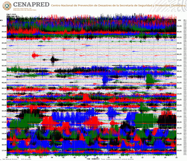
However, there’s no change in deformation in this morning’s CENAPRED graphic. Check out that tremor, though!

February 16, 2019, 3:46 p.m., Pacific: Popo is in the middle of another episode:

Chipquixtle webicorder:
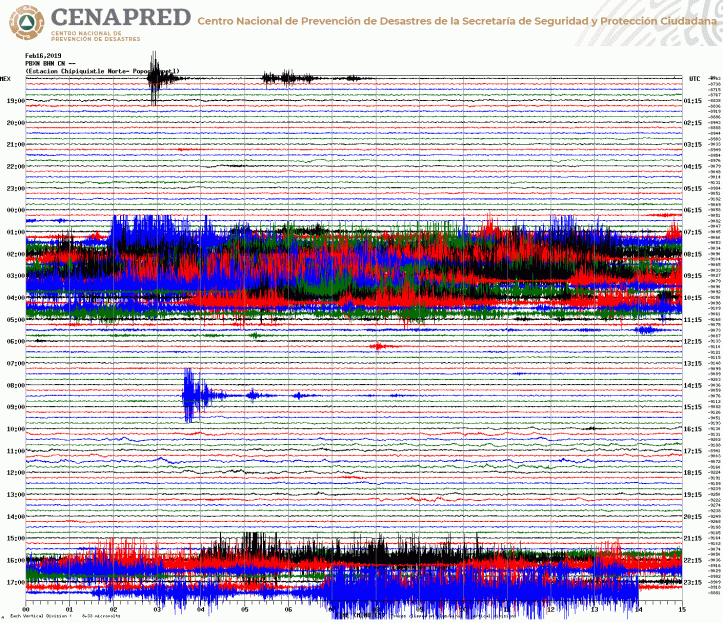
The latest news I can get via Google News and Twitter is that the alert is still Yellow Phase 2. Good. The volcanologists have excellent information sources. But as a layperson who’s just done a little reading, this still reminds me a little of “throat clearing.”
Sigh. Hope not.
4:13 p.m., Pacific: Just saw this. Still Yellow, Phase 2.
El #Semáforo de alerta volcánica del #Popocatépetl continúa en amarillo fase dos. pic.twitter.com/T7Ad7AaiR7
— PC Estatal Puebla (@PC_Estatal) February 16, 2019
https://platform.twitter.com/widgets.js
The alert level continues at Yellow Phase 2 — it’s impressive looking, especially with a setting sun behind the ash column, but there isn’t a lot of force behind it. . . yet.
Also, the view from Chipiquixtle is encouraging:
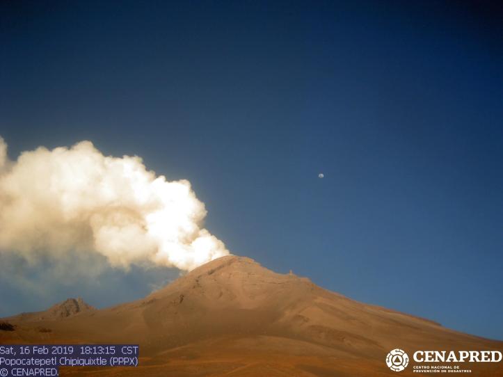
If you’re new to Popocatepetl, just a note that all the excitement is because the volcanologists who monitor this Mexican volcano in the midst of some 25 million people announced last summer that there is a large amount of magma down there and it’s going to come up, but no one knows when.
Er, I have been wrong before . . .

Incredibly, per Washington VAAC, the ash plume is heading straight north, not over Mexico City OR Puebla. Amazing!
Updated #ash advisory for #Popocatépetl:https://t.co/3O5mcMoNxR pic.twitter.com/srlEPy9g2O
— Washington VAAC (@WashVAAC) February 17, 2019
https://platform.twitter.com/widgets.js
February 16, 2019, 7:34 a.m., Pacific: It’s too early for a CENAPRED update today (and they haven’t issued any interim reports on the website linked below, which they do sometimes). However, Don Goyo put on a magnificent but terrifying show under the moonlight last night:
https://youtu.be/2CY6ItGjWj0&rel=0
Here’s the current Chipiquixtle webicorder:
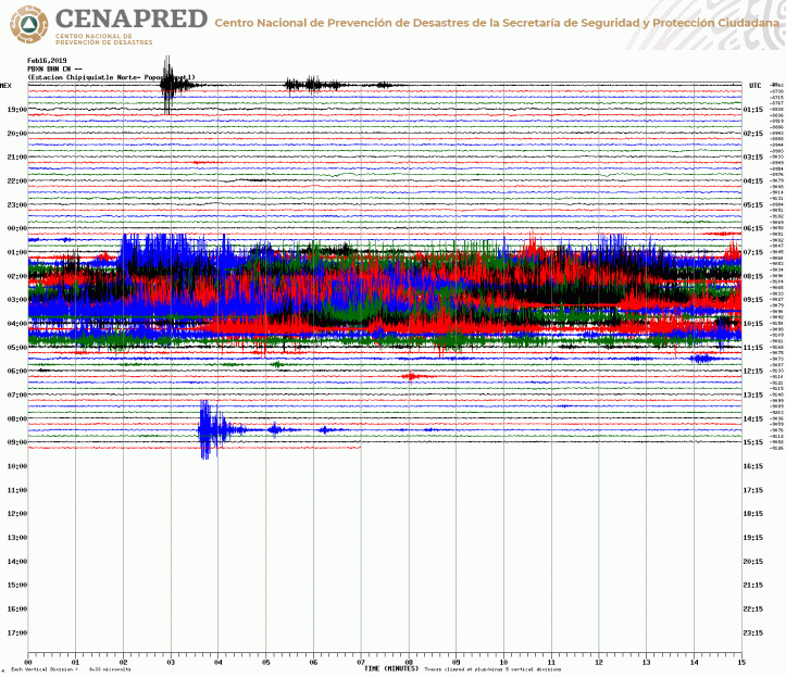
February 15, 2019, 12:56 p.m., Pacific: Strombolian activity is NOT lava dome explosions: change in eruptive activity! The alert remains at Yellow, Phase 2, though.
Per CENAPRED this morning:
February 15, 11:00 h (February 15, 17:00 GMT)
From 21:00 h yesterday began an episode of strombolian activity that consisted of harmonic tremor accompanied by explosions, which generated the emission of incandescent fragments which reached a distance of approximately 1.5 km on the flanks of the volcano, the height of the eruptive column was 2 km, which was dispersed preferably towards the southwest (vídeo 1) and (vídeo 2). The total duration of the episode was seven hours, after which the seismic activity returned to previous levels. Derived from this activity, at the time of this report has been detected ash fall in the communities of Hueyapan, Tetela del Volcán, Zacualpan, Temoac, Jantetelco, Cuautla, Ocuituco and Yecapixtla, belonging to the state of Morelos, as well as in Tochimilco, Puebla .
Additionally, 67 exhalations were recorded accompanied by steam and gases, in addition to five explosions, four recorded yesterday at 3:28 pm (image 1), 16:02 (image 2), 18:24 and 19:35 h, in all cases the eruptive column was less than 1 km high with low ash content, the last explosion was recorded at 04:09 h today (image 3). In addition, 10 minutes of low amplitude harmonic tremor were recorded. At the time of this report, continues a light emission of gases that are dispersed to the southwest direction (image 4).
CENAPRED emphasizes that people SHOULD NOT go near the volcano, especially near the crater, due to the hazard caused by ballistic fragments (image 5) and in case of heavy rains leave the bottoms of ravines by the danger of landslides and debris flows.
The Volcanic Traffic Light Yellow Phase 2.
Here are the movies they included:
This is what it looked like on the Chipiquixtle webicorder:

They should rename this volcano Jekyll/Hyde. 🙂
Webcam image from 2:59 p.m., Pacific. Yes, the volcano is under an ash advisory at the moment.

Per this Puebla PC tweet, posted about 15 minutes ago, this light-ash/gas emission just began and is heading for the states of Morelos and Mexico (Mexico City, basically); here’s a close-up from the Chipiquixtle webcam:
En los últimas horas, se registra el aumento de exhalaciones de gases volcánicos con bajo contenido de ceniza del #Popocatépetl. La dispersión prevalece entre #EdoMex y #Morelos.
[#CENAPRED, Chipiquixtle]🚦 continúa en #AmarilloFase2. pic.twitter.com/mcNRai5QTC
— PC Estatal Puebla (@PC_Estatal) February 15, 2019
https://platform.twitter.com/widgets.js
February 14, 2019, 10:23 a.m. Pacific: Aaaaand with all that on the 10th (scroll down to update), no larger event happened. Today, Popo is currently under a VAAC advisory, though.
Yesterday I was working on this Sunday’s “Morning Volcano” post, and while watching the video below realized that the early activity shown in Vesuvius in 79 AD, starting around 0:41, is exactly what Popo does (minus the “puffs”); in the video, it’s a sign of alarm for the residents. At Popo, which is so slowly ramping it, it’s just Thursday.
Sigh. Most explosive volcanoes, I understand, do progress into a full eruption rather quickly after an ash plume first appears, although there is a lot of variation from volcano to volcano and eruptions are very complicated processes; anyway, this low-level activity of long duration is one of Popocatepetl’s hallmarks.
Meanwhile, back at Pompeii . . .
https://youtu.be/dY_3ggKg0Bc&rel=0
By the way, as mentioned in some of the earlier posts, Popocatepetl does have its own “Pompeii,” called Tetimpa, in Puebla State. As in Pompeii back in 79 AD, the people living there got out in time when the volcano had an estimated VEI 4 eruption around 823 AD.
In fact, they all escaped–no human remains have been found yet at Tetimpa.
February 10, 2018 2019 (I’m still doing that!), 10:44 a.m., Pacific: This morning’s CENAPRED update is impressive (emphasis added):
February 10, 11:00 h (February 10, 17:00 GMT)
In the last 24 hours, through the Popocatepetl volcano monitoring systems, 243 exhalations were identified, accompanied by steam, gas and ash. . . Also, were recorded 34 minutes of harmonic tremor fo [sic] low amplitude. During the night the crater was visible and incandescence was observed in some the exhalations . . .
At the time of this report, continues a light emission of gases that are dispersed to the south direction . . .
CENAPRED emphasizes that people SHOULD NOT go near the volcano, especially near the crater, due to the hazard caused by ballistic fragments . . . and in case of heavy rains leave the bottoms of ravines by the danger of landslides and debris flows.
The Volcanic Traffic Light Yellow Phase 2.
Current webicorder image from Chipiquixtle:
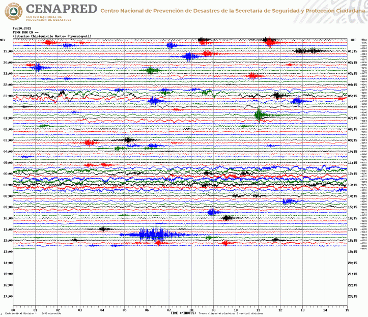
The last VAAC advisory for Popo was yesterday. Webcams do show light ash in the air around the volcano but no “puff” at the moment.
There does seem to be an rising steam plume currently, per the Los Ranchos webcam, but it is mostly obscured by cloud (hope that link works).
January 28, 2019,5:37 p.m., Pacific: CENAPRED conducted an overflight yesterday:
It’s just amazing to watch this volcano, in the midst of well over 20 million people, slowly ramping up, and there’s nothing we can do to stop it. You know it’s coming (Popo has had a few VEI 6 eruptions, and there is a pre-Hispanic “Pompeii” called Tetimpa), but you don’t know when…or really, how big it will be, though UNAM volcanologists did say last year that there was a “large” amount of magma down there not too far.
Just as a reminder, here is the CENAPRED list of risks at the volcano. Most of the words are similar in English and Spanish: “ceniza” is ash, “peligros” is dangers. In light of Anak Krakatau’s disastrous collapse recently, check out that yellow flank collapse risk to the south!
A partir de estudios científicos, el #CENAPRED en conjunto con la @UNAM_MX publicaron los mapas de peligros del volcán #Popocatépetl, integrando escenarios para las diversas manifestaciones de la actividad volcánica, su versión interactiva se encuentra en: https://t.co/TWODPrIGWp pic.twitter.com/hj75NPGTjm
— Oscar Zepeda (@capacapa) November 24, 2018
https://platform.twitter.com/widgets.js
These are all potential risks, but no one knows what the volcano will actually do next.
January 30, 2019, 1:06 p.m., Pacific: A P.S.:
I got behind while finishing up the book and missed this spectacular explosion (soon after moonrise)on January 22nd in the early evening:
https://youtu.be/hskWdcQO2F8&rel=0
That’s probably what spurred Sunday’s overflight. UNAM experts told journalists, per this article (Spanish), that it was the most significant explosion since Popocatepetl reawoke in 1994, but that the energy released was relatively low (compared to a full eruption, I suppose).
January 24, 2019,12:32 p.m., Pacific: A short but nice video posted about 4 hours ago:
Monitoreo del volcán #Popocatépetl desde la localidad de Santiago Xalitzintla, municipio de #SanNicolásDeLosRanchos.
El 🚦 continúa en Amarillo, Fase Dos. pic.twitter.com/IMv2b1Uskr— PC Estatal Puebla (@PC_Estatal) January 24, 2019
https://platform.twitter.com/widgets.js
No change in alert status, but this morning’s CENAPRED update reports quite a lot of low-level activity over the last 24 hours.
Imagine living next to a volcano that does this and has been active for 24 years this way, sloooooowly ramping up over time. That’s stressful, but so is knowing that if Popo had suddenly begun doing this, say, five years ago, everybody would be freaking out about now.
Fortunately, the volcanologists have gotten more funding, per recent news reports, and they can watch this volcano more closely; plans are to monitor it so even during inclement weather.
This volcano has had big eruptions and flank collapses in the past. Something big is coming, but no one knows when . . .
January 22, 2019,1:33 p.m., Pacific: No change in alert status. I simply noticed on the webcam that Don Goyo’s snow field is completely darkened by ash at the moment:

And the Chipiquixtle webicorder shows that the volcano is not as still inside as it appears from the outside–harmonic tremor, probably; this morning’s CENAPRED update reported over an hour’s worth of low-amplitude tremor during the past 24 hours.
Dr. Zepeda has tweeted that harmonic tremor here can be due to the movement of fluids within the edifice (not necessarily just magma).

January 18, 2019,9:08 a.m., Pacific: The current Chipiquixtle webicorder:

I thought it was volcanic at first, but the volcano seems unchanged visually:

Then I saw that this just happened about half an hour ago–USGS lists it as magnitude 6 at present:
#Ahora – sismo de magnitud preliminar 5.9 con epicentro en el Pacífico a más de 900 km al sur de las costas de México. pic.twitter.com/9LzeZnnvhq
— SkyAlert (@SkyAlertMx) January 18, 2019
https://platform.twitter.com/widgets.js
The seismic waves are going through Popocatepetl in unusual ways, as shown by the instruments at Chipiquixtle–unusual, that is, compared to how they would travel through a mountain.
Wish I were a seismologist, so I could read whatever information about the volcano’s internal workings that squiggly tracing shows!
I wonder if this will have any effect on Popo’s activity, given its currently elevated level.
Addendum, 5:02 p.m., Pacific: Apparently not, as Popo seems at its most recent baseline on the webcams and CENAPRED hasn’t addressed this AFAIK.
Here is the Chipiquixtle webicorder whole sequence, which lasted about half an hour:

January 10, 2019,9:50 a.m., Pacific: Work on the book has kept me busy, and CENAPRED hasn’t changed the alert status, so posts here have been few. However, Popo has been ramping up a bit over the past weeks (at least this layperson thinks so), and that is from an already elevated level.
I haven’t followed it in detail, but there is a little time this morning and I see this: three exhalations in an hour!
¡Entérate! En la última hora el volcán #Popocatépetl ha emitido tres exhalaciones acompañadas de vapor de agua y gas, con altura de columna de aproximadamente 500 m que se dispersa al oeste-noreste. pic.twitter.com/UYnkLKfT6P
— Oscar Zepeda (@capacapa) January 10, 2019
https://platform.twitter.com/widgets.js
The Colossus of Puebla is mostly socked in by weather clouds on the current webcams, but here’s a shot of it, merely degassing, taken about an hour ago, per a Puebla State Civil Protection tweet:

January 2, 2019,2:02 p.m., Pacific: Happy New Year, all!
This caught my eye today:
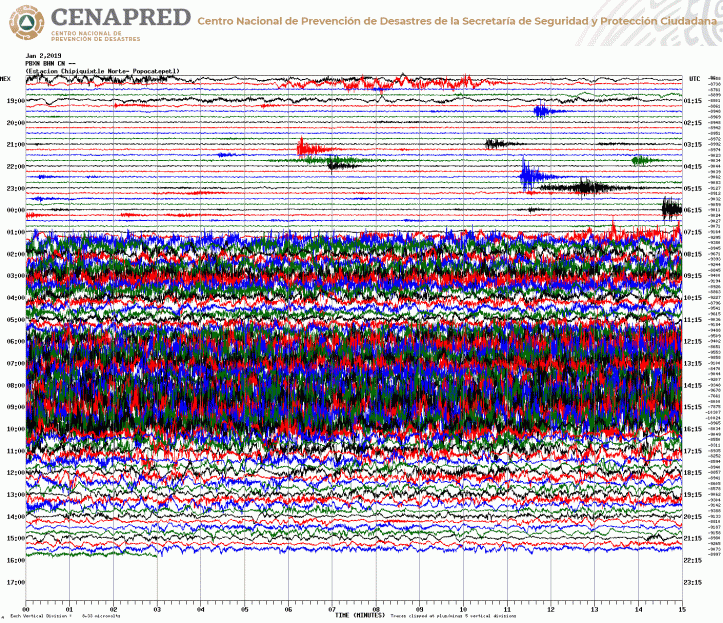
The CENAPRED update isn’t up yet at the English-language site, and I immediately checked the news: nothing major has changed with Don Goyo.
A look at the time-lapse videos shows what caused it: wind. You can’t see much in the midnight-to-0500 video, but it’s worth noting because Orion constellation slowly marches across the background sky behind the volcano, followed by Sirius.
Weather: 1. Popocatepetl: 0
https://youtu.be/MFdGGxLl3wA&rel=0
https://youtu.be/sY9C3KrZJ1c&rel=0
December 20, 2018, 9 a.m., Pacific: It’s a little too early for the CENAPRED daily update, but here is a gorgeous image from a tweet by CENAPRED’s Dr. Zepeda. In it, he also says that LP earthquakes at Popocatepetl (things like tornillos, I suppose) are from the movement of fluids inside the volcano’s conduit.
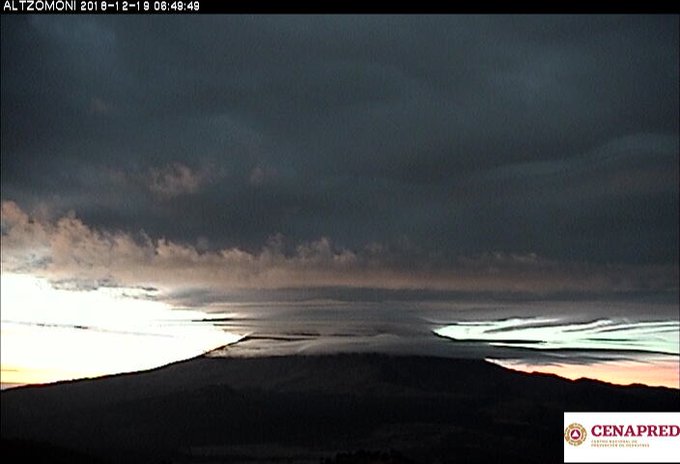
December 17, 2018, 1:23 p.m., Pacific: There is a typo in the English-language CENAPRED bulletin (see link near top of page) for today: it’s 139 exhalations per the Spanish-language report (this link may or may not work, but it’s the official one), not 1,139.
Nevertheless, per this same report, the deformation is slightly up and seismic activity is noticeably elevated over the last 24 hours (though as Dr. Zepeda pointed out in a tweet, it didn’t increase after Saturday’s big explosion):

Alert status is unchanged, and actually Popocatepetl is back to its apparent waiting game today. Still, the Chipiquixtle webicorder shows that the volcano is not asleep.

That is low-level, routine activity in this currently elevated phase of the eruption.
What I’m going to keep an eye out for in coming days, weeks, months–and years are not out of the question with this volcano!–is an increase in deformation.
Remember, now, I’m a layperson and this is just speculation. Still, I recall seeing the epicenters of recent earthquakes shown in a CENAPRED graphic from late November:

Assuming that those epicenters mark the present location of the large quantity of magma that volcanologists mentioned a few months ago, it apparently hasn’t gotten into the edifice yet, but is fairly close.
I assume that rising magma is keeping the conduit pressurized and resulting in the increased level of activity. When those epicenters get higher up in the current volcanic mountain, there will be trouble.
Or the eruption could just stall out. No one can see that deeply into the Earth to say what is going on down there.
Volcanoes are very difficult to understand, and I respect enormously those scientists who rise to the challenge and try to do that and also to predict their activities.
We’ll just have to wait and see what Popocatepetl does next.
December 16, 2018, 10:45 a.m., Pacific: No change in the status, but Popo had a big explosion last evening, not long after sunset. It had been rather active during the day, too, as this CENAPRED video shows:
Here is the time-lapse with the explosion, which covered the entire summit with fragments.
https://youtu.be/SwcKRrE29O0&rel=0
I thought there might be events overnight, but the volcano appeared quiet, without showing incandescence, per CENAPRED’s report this morning.
Now, though, waviness is showing up on Chipiquixtle webicorder again and Popo may have more fireworks in store later today and/or tonight.
Addendum: Just across this tweet by Puebla State Civil Protection and learned that Don Goyo had already set some off earlier this morning.
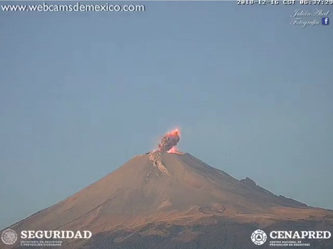
December 12, 2018, 9:23 a.m., Pacific: I am preparing my two ebooks on domestic cats for publication and, while keeping an eye on Popo, probably won’t be documenting anything less than a major change, like raising the alert level (lowering it does not seem likely in view of the volcano’s continuing to crank up activity).
Still, you don’t see this very often! It’s undoctored and from a reliable source.

A meteor really did fall over Popocatepetl at night!
December 8, 2018, 4:41 p.m., Pacific: At the moment, the webcams are clear and Popo appears quiet, but it has been active. Check out the daily update (link to English version up above); there is also a VAAC advisory out, I think. The Chipiquixtle webicorder “waviness” did settle down, but after that came the intermittent explosions, including this one last night:
That’s one big firecracker!
I think the waviness did mean extruding lava/degassing; when it got blocked, perhaps, is when explosions happened.
Still, the volcano’s status is Yellow, Phase 2.
December 7, 2018, 12:43 p.m., Pacific: Today I could spend some time with the Los Ranchos live stream, and the weather around Popocatepetl cooperated, too. To my layperson’s eyes, it looked like a steady but very low-level emission of stuff, with one “puff” (what CENAPRED calls “exhalations”).
Interestingly, at the “puff,” a hush fell over the human-generated background noises: everybody in the region must keep an eye out for activity from this “smoking mountain.” Only a few minutes after it had settled down did the noises resume.
I noticed that much of the emission was a bluish-white, compared to the weather clouds nearby. At height, it was very light ash. I’ve read that sulfur compounds from volcanoes are bluish-white; there seemed to be quite a bit today. Erupted lava or magma near the surface would degas; I’m thinking it’s lava, since sometimes the rising bluish-white stuff would be vertical for a ways above the crater rim, signifying a thermal plume heat source, before it dissipated, leaving the ash to continue rising.
There seemed to be very little steam, at least over the last hour and a half or so. Also, no explosive gray ashy clouds appeared, either. The puff was a little grayish but not much, in comparison with other recent activity.
So that activity on the Chipiquixtle webicorder (see earlier note this morning) was perhaps the movement of gas or perhaps lava extrusion?
Whatever it was, it seems to be calming down a bit now.
Wonder if we’ll see bright incandescence tonight . . .
December 7, 2018, 10:22 a.m., Pacific: Well, the Chipiquixtle webicorder doesn’t look good . . .

. . . but the volcano appears relatively quiet on the Los Ranchos camera (see embeds above or in yesterday’s post below). However, it’s under a VAAC advisory because of a small emission several hours ago. That looked pretty small on the video included in today’s CENAPRED update, not worthy of such seismic disturbance as seen on the webicorder at present.
Am thinking the dome is really under pressure now and we can expect fireworks soon.
Of note, yesterday’s events led to ashfall in two nearby communities, per CENAPRED this morning.
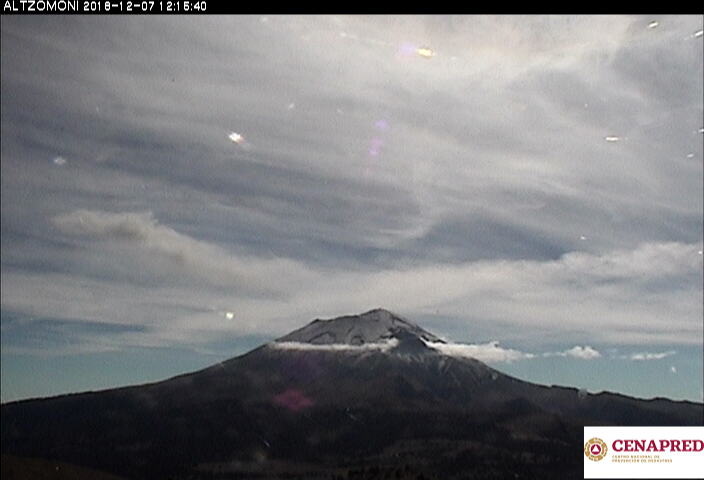
December 6, 2018, 1:52 p.m., Pacific: Well, it seems to be slackening off a bit, though there is still continuous emission. Shortly after the last note, a column went up fairly high, but then it fell victim to the upper winds: still not enough convective energy to mount a “normal” eruption plume.
Yet.
We’ll see how it goes. I’ve got to get to work, but will include a time-lapse video of the afternoon’s events from this source later.
Update, 4:08 p.m., Pacific: Here it is: Unfortunately, it’s too cloudy up there to see much. Things seem to be clearing towards the end of the video, though the volcano is still socked in on the webcam I just checked. Perhaps it will clear tonight.
https://youtu.be/t0X3U_iouOw&rel=0
December 6, 2018, 1:38 p.m., Pacific: Just checked the cam routinely, and there appears to be more of a traditional eruption going on–very low level at the moment–not the typical “Popo puff.”
The Los Ranchos cam is interesting:
https://youtu.be/jBLOiMHJbq8&rel=0
Here’s a screen shot from the Tlamacas webcam:

It looks to me like the volcano is trying to get going, but not quite ready for it yet. However, alert level is still Yellow Phase 2 and no VAAC advisories are up at the website as far as I can tell.
December 6, 2018, 12:07 p.m., Pacific: This happened about an hour ago, per Dr. Zepeda, who also tweets a video of the event:

I don’t see a VAAC advisory up for it yet, though Popo did get one overnight for another eruption. Per today’s CENAPRED update, they registered almost 200 minutes of harmonic tremor over the last 24 hours!
Here’s the graphic from today’s report:

Per Puebla’s Civil Protection Twitter feed this morning, modeling shows that any emissions today will head over Mexico City (the other side of the range from Puebla).
December 5, 2018, 10:11 a.m., Pacific: More of the same, actually: overnight incandescence and explosions, but quieter spells, too. VAAC advisories were issued, but they just gave Popo the all-clear again.
With this morning’s update, CENAPRED issued a lovely video of an eruption around sunset last night, as viewed from the Tlamacas cam. (Note: It isn’t dramatic, compared with, say, Pinatubo’s 1991 activity, but this is very elevated activity for Popocatepetl, and this eruptive column goes a little bit higher and lasts longer than the vulcanian puffs here have been doing: the volcano is cranking up, for sure, but it could continue this way for some time or just let loose suddenly. This must be one of the most difficult volcano emergencies to monitor in the world right now, and it’s soon to go into its 25th year.)
December 4, 2018, 10:47 a.m., Pacific:
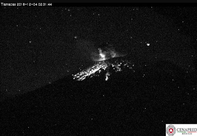
Popo has been more active the past two days, but unfortunately so have I; could only get to it now.
CENAPRED’s Dr. Zepeda tweets (I ran it through Google Translate):
In the last 24 hours, through the monitoring systems of Popocatépetl volcano, we identified: – 70 exhalations – 2 explosions – 25 minutes of harmonic tremor – 8 volcanotectonic earthquakes The 🚦 remains in Yellow Phase 2 pic.twitter.com/ k9Jv26m9yh
It is recommended: 1. Continue with the radius of 12 km, so that staying in that area is not allowed. 2. Maintain controlled traffic between Santiago Xalitzintla and San Pedro Nexapa, via Paso de Cortés. 3. To the PC authorities, maintain their preventive procedures.
Here is the graphic from today’s update:

There have been a number of VAAC advisories, yesterday and thus far today, but at the moment they give the volcano all clear.
December 2, 2018, 10:09 a.m., Pacific:
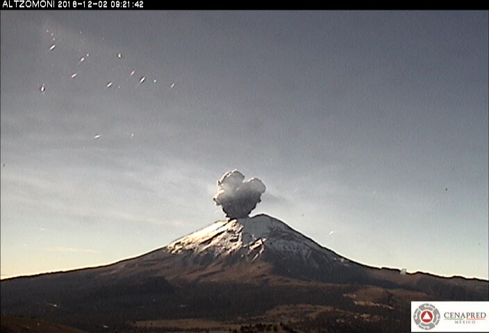
However, the Chipiquixtle webicorder shows none of that former “waviness” now, though this explosion (there was one earlier today, too, per CENAPRED) and other events are there.

At the moment, the webcams are clear and there appears (to me, anyway) to be an unusual double plume: one of steam (the white curly “Don Goyo” clouds) and one of gas (sulfur gases at volcanoes are sometimes bluish-white):
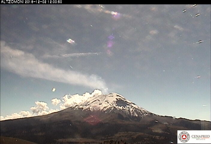
The plumes from another webcam:
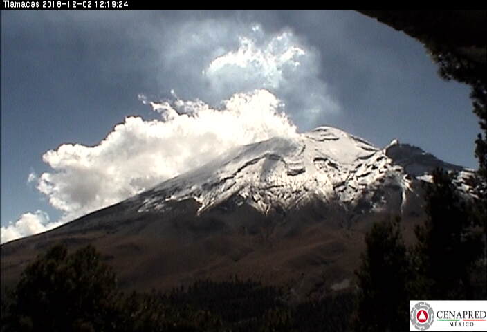
Here is video of the first explosion (toward the end, after moon–such as it is–has risen); scientific cameras don’t do justice to what must be a majestic scene in real life as the stars slowly progress across the clear night sky over the steaming mountain!
https://youtu.be/Kr_jh4vioV4&rel=0
There seems to have been a smaler “puff” a few moments before the big boom (which was probably the lava dome partially exploding).
Here is this morning’s time-lapse video. I see three events in this one, but the volcanologists must be more precise and, of course, know more about what’s actually going on in the crater.
https://youtu.be/k2D23rUppSk&rel=0
This one interests me because you can see emissions increase before that first (and largest) explosion; I haven’t noticed that with other explosions at Popo that I’ve happened to catch.
A news report (Spanish) from the 29th says that army representatives are visiting communities near the volcano to check on and coordinate with their “Plan Popocatepetl.”
This is good preparation, of course, and it’s probably also meant as reassurance–have seen other reports of rumors of impending huge eruptions earlier this past week. Government officials and scientists denied them all.
It struck me that this happened while Popo was completely shrouded day after day in cloud. I can understand the psychological effect of that–it’s so much easier to deal wtih a restless giant that you can actually see.
Glad the Colossus of Puebla wasn’t hidden during its explosions over the last several hours!
November 30, 2018, 2018, 4:32 p.m. Pacific: No change from yesterday, and no new VAAC advisories. Things seem to be clearing at the time of writing, and I wanted to embed this video, which is only interesting toward the end, where you can see an enormous cloud of steam (looks like) coming from the volcano; indeed, I wonder if the obscuring clouds earlier were from that or from weather. I’ve never seen Popo with such a big cloud of steam (but I haven’t been observing it for very long, either):
https://youtu.be/d3sej4t5h0s&rel=0
November 29, 2018, 6:51 p.m., Pacific: Whatever was happening to disturb the Chipiquixtle webicorder seems to have settled down in the last few hours. The volcano is still socked in. No VAAC advisories, fortunately (volcanic ash gets very heavy when wet, so rainfall during a productive eruption is bad news).
November 29, 2018, 12:11 p.m., Pacific: No VAAC advisories since the 26th.

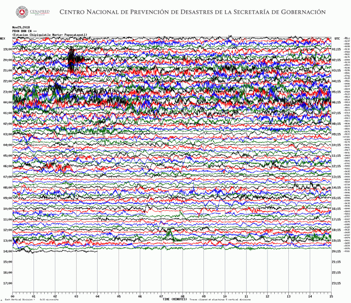
My guess is: (a) Popo is having a few vulcanian eruptions per usual, but the ash isn’t getting through the weather clouds; (b) the dome is pressurizing and getting more and more unstable.
November 28, 2018, 3:19 p.m., Pacific: Not sure what’s going on up there; unfortunately, the volcano is socked in on the webcams just now.
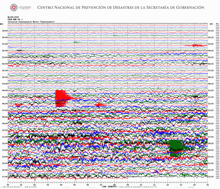
Dr. Zepeda tweets that Popo had an explosion at 12:57 p.m.
There are no VAAC advisories in effect for Popocatepetl today, though it did trigger one yesterday.
November 27, 2018, 9:21 p.m., Pacific: CENAPRED’s Dr. Zepeda tweeted this image of the locations of volcanotectonic quakes over the month of November; red is oldest, blue is most recent.
At the moment, there is some waviness on the Chipiquixtle webicorder and, though it’s difficult to see, what looks like a good head of steam from the summit, per the Tlamacas came. No VAAC advisories since the 23rd.
November 26, 2018, 11:06 p.m., Pacific: A little waviness on the Chipiquixtle webicorder, but not as much as those shown below.
This video is interesting because it’s not really clear what’s going on after sunset at first. Is that incandescence in the upper right (Tlamacas cam)? I don’t know. But then the moon slowly rises and the scene brightens to show Popo is emitting lots of steam. Note the gleam in the lower right (Chipiquixtle cam)–that’s not incandescence, which this cam doesn’t seem to pick up, even during nights of intense activity as on the 20th; that’s the moon peeking through the steam clouds as it rises above Popocatepetl’s summit.
https://youtu.be/__qAONZLwAY&rel=0
November 26, 2018, 1:48 p.m., Pacific: I think Don Goyo is playing games with us. The Canario/Chipiquixtle webicorder current image is below, but CENAPRED only reports 5 minutes of tremor and does not mention earthquakes over this period. (More realistically, the dome is probably slowly pressurizing and will eventually blow in coming days or weeks.)

About 8 hours ago, Washington VAAC said there might be ash emission, but later said it wasn’t. Certainly, from the webcams, very light ash is visible floating in the air around the volcano–that’s par for the course.
Dr. Zepeda tweeted this image of where each of CENAPRED’s cams (not all of them are online) are located relative to the volcano.

‘
November 26, 2018, 12:38 a.m., Pacific: A late-night check. Popo had another episode of “wavy stuff” (am assuming that’s LP quake and tremor activity; will see if CENAPRED mentions it in tomorrow’s update). However, it settled down again (well, mostly–the waviness is still there somewhat). The webcam from Los Ranchos is clear and there is no incandescence at the crater. The volcano seems to be leaking light quantities of ash, per baseline these days, but nothing that has called for a VAAC advisory since the 23rd.

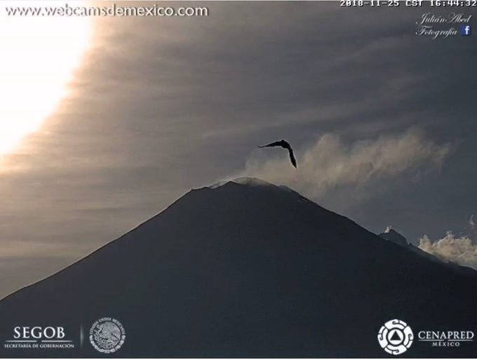
Not much change in the daily update today (you can read those at the link near the top of this page).
Fortunately, whatever was going on in the volcano did not lead to an increased activity level. Here is the whole webicorder readout for yesterday’s activity (such as it was):

November 24, 2018, 7:48 a.m., Pacific: Popo has continued to be sedate up until this morning. Just in the last hour or so there seems to be more waviness (tremor) on the Chipiquixtle webicorder, and in camera views it appears to be puffing more frequently–nothing intense yet, just a mild uptick.
Note the earthquake series that precedes the change.

Per Puebla’s PC_Estatal Twitter (Civil Protection officials in Puebla), this was going on before sunrise:
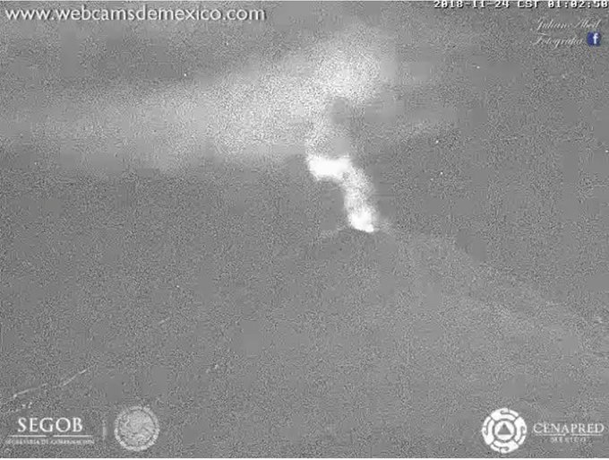
November 22, 2018, 11:58 a.m., Pacific: CENAPRED did an overflight of the crater this morning, taking advantage of the lull in explosive activity.
https://youtu.be/D3GiD4JfgP8&rel=0
November 21, 11:00 h (November 21, 17:00 GMT)
In the last 24 hours, through the Popocatepetl volcano monitoring systems, 46 exhalations were identified, accompanied by steam, gas and light amounts of ash (image 1). Additionally, an exhalation train of long period events accompanied by tremor with duration of 1441 minutes was recorded, registered from November 20 at 14:27 h, to November 21 at 16:07 h. The intense phase lasted 790 minutes (13 h) from November 20 at 16:07 h until yesterday at 05:07 h. Finally one volcanotectonic event was recorded yesterday at 10:09 h with magnitude 2.6 and seven minutes of harmonic tremor. During the night was possible to observe incandescence at the moment of some events (image 2).
Today, with the support of the Secretary of the Navy (SEMAR), an over flight was made in the vicinity of the Popocatépetl volcano, was possible to observe the 80 dome with an estimate diameter of 250 meters, thickness around 30 meters and a volume of 1.5 million m3 (imagen 3), (image 4), (image 5), (image 6), (image 7), (image 8) y (video 1)
At the moment of this report is possible to observe that the emissions of steam, gas and light amounts of ash are dispersed to the south-southeast direction (image 9).
CENAPRED emphasizes that people SHOULD NOT go near the volcano, especially near the crater, due to the hazard caused by ballistic fragments . . . and in case of heavy rains leave the bottoms of ravines by the danger of landslides and debris flows.
The Volcanic Traffic Light Yellow Phase 2.
I’ve had to reset my equipment because of a hack, and in this new browser, am unable (at the moment) to figure out how to get a Twitter embed code. Nevertheless, CENAPRED’s Dr. Zepeda tweets that Popo is extruding lava at a rate of roughly 1100 cubic feet (31 cubic meters) per second.
November 21, 2018, 7:50 p.m., Pacific: Popo continues to be much more sedate this evening, but it’s still having enough ash admission for a new VAAC advisory about half an hour ago. Dr. Z. tweets that (per my translation), “At the moment, in the last 12 hours, the amplitude of LPs [quakes] and tremor has diminished. The water vapor and gas emission is constant and in an east-northeast direction. The volcanic traffic signal alert continues at Yellow Phase 2”:
Al momento #Popocatépetl: en las últimas 12 horas, la amplitud de LP’s y tremor ha disminuido. La emisión de vapor de agua y gas es constante en dirección preferencial E-NE. El 🚦de alerta volcánico continúa en #AmarilloFase2. pic.twitter.com/kB0rnoGmyQ
— Oscar Zepeda (@capacapa) November 22, 2018
https://platform.twitter.com/widgets.js
Going by the following tweet, am thinking they might have raised the alert to Yellow, Phase 3 last night if they had seen a pyroclastic flow.
Below this tweet is my translation–not verbatim–of the Phase 3 and Red, Phase 1 criteria:
Lean el siguiente hilo sobre el semáforo de alerta volcánica para entender cuándo cambia.
Seguimos en amarillo fase 2. pic.twitter.com/1alQtuSp4b
— Volcán Popocatépetl (@Popocatepetl_MX) November 22, 2018
https://platform.twitter.com/widgets.js
“Yellow, Phase 3: Creation and destruction of lava domes; persistence of fumaroles of gas, and light ashfall in nearby areas; increasingly intense explosions with ejection of incandescent fragments . . . ”
Ahem . . .
Ult 24 h:
•18 exhalaciones.
•0 explosiones.
•0 sismos VT.
•1173 min de tremor que continúa (790 min la fase más intensa).Estaría formándose un domo de lava.
«🚦Amarillo 2» pic.twitter.com/H35x9Qbyjj
— Volcán Popocatépetl (@Popocatepetl_MX) November 21, 2018
https://platform.twitter.com/widgets.js
“Yellow, Phase 3 (continued): . . . possible moderately long pyroclastic flows.”
“Red, Phase 1: Eruptive column of water and gas several kilometers high; ejection of incandescent fragments over the volcano’s flanks; significant ashfall on neighboring populations; pyroclastic and mud flows [lahars] that can threaten nearby populations.”
Yes, Popo is capable of that, and even more violence. But unlike any other volcano I’ve ever heard of (remember, though, am a layperson and not familiar with many volcanoes), Popocatepetl has been doing this low-level stuff for 24 years now. It may continue for another few decades–or it may get more active again in the next moment.
It’s very hard for most of us to grasp, accustomed as we are to the “disaster movie” scenario of an eruption (thanks, Mount St. Helens, 1980!). It must be very trying for the millions who live near Popocatepetl.
And perhaps the most the volcanologists can do–like meteorologists with an approaching line of severe/tornadic supercells–is try to give as much warning as possible if worse comes to worst and to keep talking with people, informing them and keeping their minds on emergency procedures as time passes and the volcano just simmers on the horizon.
This is quite a remarkable volcano emergency.
November 21, 2018, 1:14 p.m., Pacific: CENAPRED issued updates yesterday (they’re in English at the update link near the top of this page). Here is how they describe events at Popocatepetl:
. . . [A]n exhalation train of long period events accompanied by tremor with duration of 1173 minutes . . . registered from 14:27 h yesterday and continues at the time of this report (video 1). The intense phase lasted 790 minutes (13 h) from yesterday at 16:07 h until today at 05:07 h . . .
Here is a time-lapse video from the Altzomoni webcam that they also shared. Both the frequency and the energy of the exhalations are worth noting–a change from recent activity. Still, though, the energy is not forceful enough to be independent of wind except near the summit.
Those gathering weather clouds now obscure the summit in the webcams, but the Chipiquixtle webicorder shows how dramatically events slowed down from about 6 a.m. local time:

So . . . what next, Don Goyo?
El volcán #Popocatépetl visto desde #Tochimilco: pic.twitter.com/evsyV8hKz3
— PC Estatal Puebla (@PC_Estatal) November 21, 2018
https://platform.twitter.com/widgets.js
Oddly, I can find no reports of ashfall. The authorities are warning people about it, but there just don’t seem to be reports.
Am still going to maintain my prediction from last night. In review:
- The events continue at this level for a while; this is not an extended “puff.”
- Lava accumulates and eventually fills the crater.
- When the crater is filled, a new summit forms and collapses, forms and collapses, as more lava is erupted–the result is a series of pyroclastic flows.
- Eventually the magma stops moving upward (at least as quickly as it is doing now), the rock hardens, and that lovely elliptical crater Popo used to have is no more.
This, even though I’m wrong about the duration of the intense activity; that’s just a matter of degree. This isn’t a puff.
Will suggest that, with so much rain lately, groundwater is interacting with the lava as it is erupted–Popo had a crater lake, I’ve read, before 1994–resulting in extremely small particles, through myriad steam explosions, that just aren’t heavy enough to come down in quantities large enough to notice, except near the volcano’s crater, i.e., on the volcano itself.
Might be prejudiced toward that interpretation since the alternative I can see is that the main magma bulk hasn’t come up yet.
Well, time will tell. In the meantime, here is what the Colossus of Puebla looked like from Mexico City early this morning.
Buenos días desde cdmx y al fondo @Popocatepetl_MX
Pocas veces visto desde la cd. pic.twitter.com/j4kNlDnyy8— Paulo Serafin (@paulosera20) November 21, 2018
https://platform.twitter.com/widgets.js
My translation, assisted by Google Translate:
Good morning from Mexico City, and in the background Popocatepetl, as seldom seen from the city.
6:32 p.m., Pacific: I’ve decided to continue updates up here, but be sure to check the note immediately below (from around 5 p.m.) for details of the current phase of activity.
Just saw this, from about 20 minutes ago: yes, it could be bombs–certainly that’s what it appears Popo is emitting–but at which point could something like this be called a pyroclastic flow, I wonder.
El volcán #Popocatépetl a las 20:12 h… arrojando fragmentos incandescentes: pic.twitter.com/MAvJj1id5e
— PC Estatal Puebla (@PC_Estatal) November 21, 2018
https://platform.twitter.com/widgets.js
Popo’s seismic pattern on the Chipiquixtle webicorder seems to slow down and then pick up again, but overall it does seem a bit lower than earlier this evening, though still very elevated above baseline.
6:47 p.m., Pacific: Per another tweet from Puebla Civil Protection just a few moments ago, the alert level remains the same: yellow, phase 2.
20:33 h: pic.twitter.com/MpKYkfkia5
— PC Estatal Puebla (@PC_Estatal) November 21, 2018
https://platform.twitter.com/widgets.js
7:22 p.m., Pacific: OK, I’m thinking while I’m watching Popo’s summit glow bright, throw some bombs, and then fade out again. Here is the current Chipiquixtle webicorder:
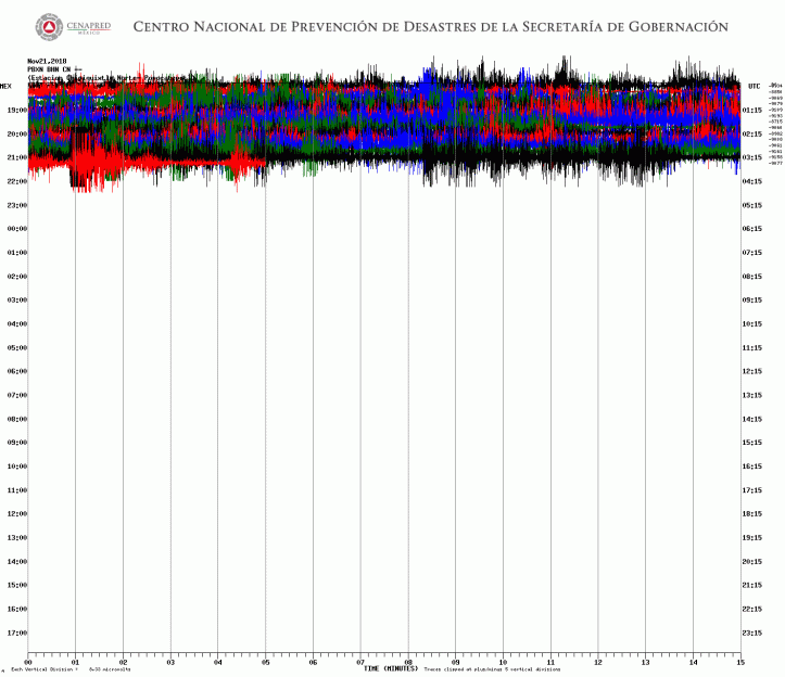
It looks to this layperson like the lava is coming up–very sticky lava, not at all like Kilauea’s runny red stuff; it rises, rises, rises, and then gravity takes over and it collapses. A much slower process happened at Mount St. Helens over ten years ago:
https://youtu.be/h6B1myUKAS4&rel=0
Today at Popocatepetl, I’m thinking, that is happening very quickly, but it continues rather than just freezing over, so to speak, to form a dome so pressure can build up and we have a tremendous blast.
Instead, the volcanic conduit remains clear and the magma squeezes out sort of like toothpaste. This is the lower, more steady part of the signal. Then it topples over: the big waves in the signal (and the big glow and bombs seen on the webcam).
All well and good–with the volcanologists saying there is a lot of magma available, that’s probably the best case scenario. Just squeeze it all out relatively slowly, without any catastrophic blasts!
So if this is correct, what can we expect?
- The events continue at this level for a while; this is not an extended “puff.”
- Lava accumulates and eventually fills the crater.
- When the crater is filled, a new summit forms and collapses, forms and collapses, as more lava is erupted–the result is a series of pyroclastic flows.
- Eventually the magma stops moving upward (at least as quickly as it is doing now), the rock hardens, and that lovely elliptical crater Popo used to have is no more.
That’s my attempt at science–making a prediction. We’ll see if it comes anywhere near the reality of the coming hours, days, and week.
Of note, when they adjusted the lens on the web cam, it was once true color, and breathtakingly beautiful–the whole night scene, including the plume, is shades of blue, because of moonlight, and all the “white” light in the images is actually red and orange. Gorgeous!
9:01 p.m., Pacific: This time I remembered to catch it!

9:59 p.m., Pacific: VAAC advisory on constant emissions dated about two hours ago is up.
November 20, 2018, [around 5 p.m.] Pacific: Looks like a lava dome that was possibly constructed since last night just blew up, about 15 minutes ago:
Explosión en el volcán #Popocatépetl a las 18:44 h que arrojó fragmentos incandescentes a corta distancia: pic.twitter.com/BessLtxdci
— PC Estatal Puebla (@PC_Estatal) November 21, 2018
https://platform.twitter.com/widgets.js
There is very intense incandescence showing in the Los Ranchos live stream now.
Here is what it looked like on the Chipiquixtle webicorder:
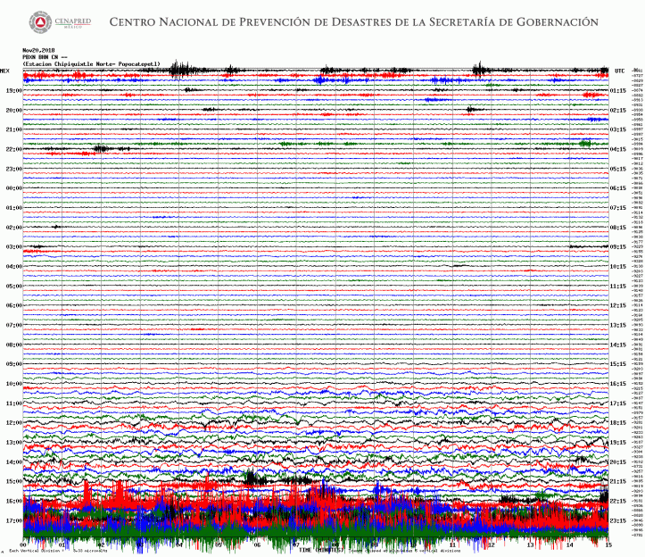
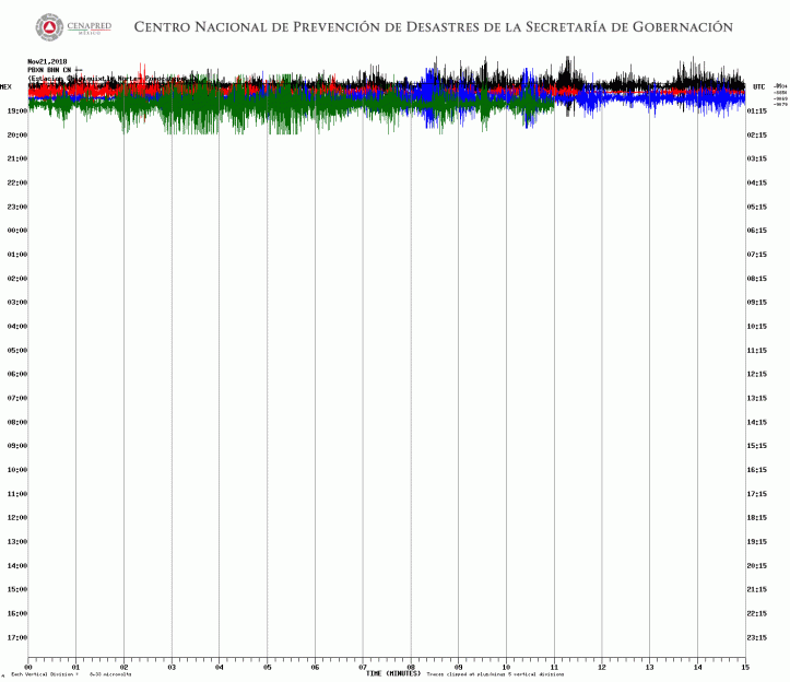
Check out that Los Ranchos cam: CENAPRED (presumably) is occasionally altering the filters–there appears to be stuff occasionally overflowing the crater rim!!!!
5:19 p.m., Pacific: It was bombs, not a flow; the lens changes became dark with a few orange areas, especially near the crater–probably thermal. Am guessing they were looking for a flow. From reading, I understand that the risk now is that Popo’s crater may be almost full and pyroclastic density currents are possibly.
No VAAC pronouncements; nothing new re: alert level.
Some of those bombs, though, are huge, judging by how big they appear all the way from Los Ranchos.
For example:

6:03 p.m., Pacific: Signature on the Chipiquixtle webicorder has decreased, though the show at the webcam is still dramatic.
Here is the time-lapse through 6 p.m. local time; you can see the intensity pick up towards the last third of the video, although Popo has had a respectable emission level all day.
https://youtu.be/2Y7BeG5P_E8&rel=0
Still no VAAC advisory.
6:15 p.m., Pacific: Chipiquixtle webicorder now. Note currently line (black) compared with the earlier red line. Hopefully Popo is just going to taper off to whatever its baseline can be called today (again, this is all very elevated activity compared to the last months and years of the eruption, while I’ve been watching on the webcams).

6:26 p.m., Pacific: However, Popo keeps throwing bombs and someone keeps fiddling with the lens. I captured this image, which is fascinating because it seems to show two high-temperature images: are there two domes in the crater, or a single irregular one, protruding above the crater rim?
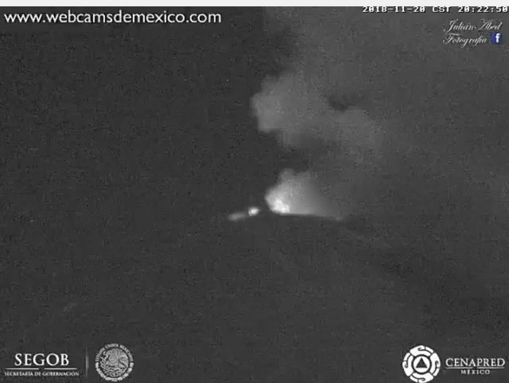
November 20, 2018, 11:27 a.m., Pacific: Still yellow, phase 2, although the column is getting higher before the wind can affect it . . .

. . . and there was a looong sequence (454 minutes) of low-amplitude tremor and LP events last night, per CENAPRED (not surprising, given the incandescence):
En las últimas 24 horas, por medio del monitoreo del #Popocatépetl se identificaron 113 exhalaciones acompañadas de vapor de agua, gas y ligeras cantidades de ceniza y una explosión ayer a las 12:24. El #CENAPRED exhorta a NO ACERCARSE al volcán y sobre todo al cráter. pic.twitter.com/CBsU70MzU0
— Oscar Zepeda (@capacapa) November 20, 2018
https://platform.twitter.com/widgets.js
The Chipiquixtle webicorder is showing that wavy stuff again, though clearly there is no apparent weather issue up there (see above cam capture from Altzomoni); perhaps this is the LP/tremor described in this morning’s update:
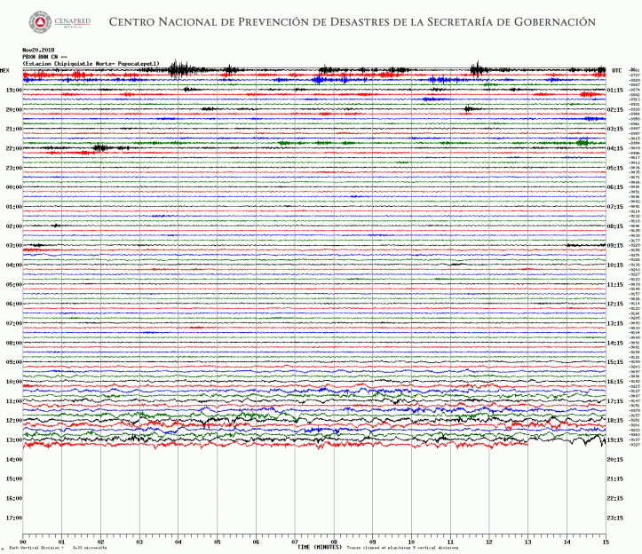
Heh–this blog update is in English, Spanish, and “Earth-speak.” Nahuatl, too, if you include place names. Quite a blend!
Modeling shows that any ash today is going to head for Mexico City–it’s a major public holiday in Mexico, and I hope Don Goyo keeps a tight rein.
Modelo HYSPLIT – NAM indica que la ceniza en caso de emisiones del volcán Popocatépetl en las próximas 24 horas se dirigiría hacia:
• San Juan Amecac
• Teolco
• Tepexco
• #EdoMéx
• #Morelos pic.twitter.com/87Oq6fbCs1— PC Estatal Puebla (@PC_Estatal) November 20, 2018
https://platform.twitter.com/widgets.js
Washington VAAC issued a couple of advisories overnight but at the moment considers Popocatepetl clear.
November 19, 2018, 9:24 p.m., Pacific: Incandescence at the moment seen on this video (links to Webcams de Mexico don’t always work for me).
El volcán #Popocatépetl esta noche se observa con actividad fumarólica constante y con el reflejo incandescente de un cuerpo de lava alojado al interior del cráter: pic.twitter.com/xZQYYQFAqc
— PC Estatal Puebla (@PC_Estatal) November 20, 2018
https://platform.twitter.com/widgets.js
My translation:
Observation of Popocatepetl volcano shows constant fumarole activity with reflected incandescence from a lava body inside the crater.
No word on any change in the alert level status (which wouldn’t be expected to change for something like this). Interestingly, it doesn’t show on the Chipiquixtle webcam; it should. Wonder if they turn that off at night, at least the light-sensing equipment.
November 19, 2018, 7:28 p.m., Pacific: Was tied up with the upcoming ebook all day and missed some activity around the middle of the day. Washington VAAC now says emissions have cleared, but this time-lapse is interesting: that column has no problem overcoming the summit winds until it runs out of material. I think this is something fairly new. And not good. I wonder what cuts off the eruption . . .
Video de la explosión del #Popocatépetl de las 12:25. El #CENAPRED monitorea diversos parámetros del volcán que permiten conocer su comportamiento de manera preventiva. pic.twitter.com/9N3sK7Eves
— Oscar Zepeda (@capacapa) November 19, 2018
https://platform.twitter.com/widgets.js
November 19, 2018, 9:34 a.m., Pacific: Popo continues its antics today. This image is from an emission about an hour ago (and the tweet also includes the CENAPRED daily update); they’re expecting ashfall in several Puebla State communities, per another PC_Estatal tweet.
⏳El volcán #Popocatépetl en las últimas 24 h presentó:
▪118 exhalaciones de vapor de agua, gases y ligeras cantidades de ceniza.
▪ 4 explosiones ayer.
▪ 1 sismo VT ayer a las 16:53 h, M= 3.0
▪ 10 minutos de tremor de baja amplitud.
{Fuente: #CENAPRED} pic.twitter.com/T9THeZpXU7— PC Estatal Puebla (@PC_Estatal) November 19, 2018
https://platform.twitter.com/widgets.js
Addendum: Here is a time-lapse of that “puff”–these contain more ash and last longer, with a little more convective force, than what I’m used to seeing from Popo (this in addition to the increased frequency of events).
En las últimas 24 horas, el monitoreo del #Popocatépetl, identificó 118 exhalaciones acompañadas de vapor de agua, gas y ligeras cantidades de ceniza, cuatro explosiones a las 12:57 h, 14:11 h, 14:31 h y 19:57 h, así como un sismo volcanotectónico a las 16:53 h de magnitud 3.0. pic.twitter.com/pjAnkiYd8Q
— Oscar Zepeda (@capacapa) November 19, 2018
https://platform.twitter.com/widgets.js
Also, I found a “new” seismic station this morning–it apparently is near the new Chipiquixtle webcam close to the summit, and so probably was put up at the same time. Here is one of the four webicorders shown at the moment–no idea what all that wavy stuff is around midnight. Washington VAAC did issue an advisory around that time, but the emission was so weak that, they say, it hardly left the crater. It was hard to see because of a passing cloud, per the advisory. So this waviness could be weather related, but it doesn’t look like any wind signature I’ve seen (granted, my experience is extremely limited).
No doubt it all fits into the greater volcanological picture that CENAPRED has.
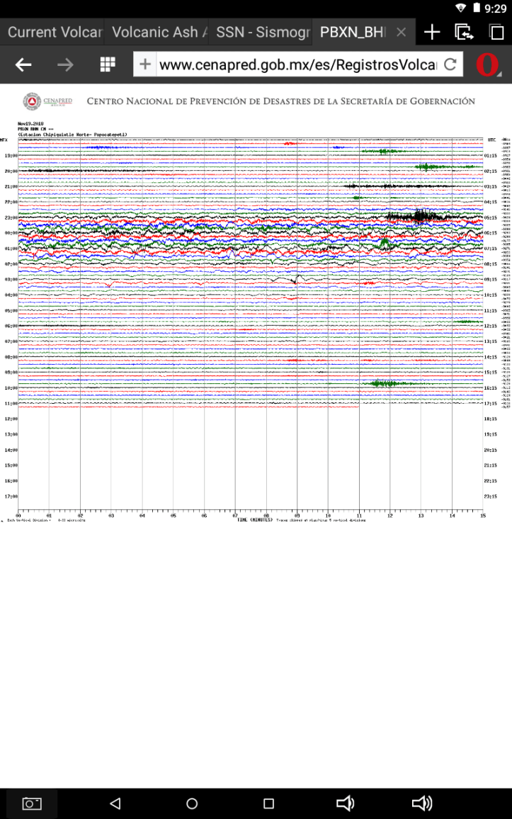
The other three webicorders on this page are from earlier recordings. Here is what yesterday afternoon looked like to the Canario station seismic equipment:

And here is the graphic from today’s CENAPRED report. It’s good to see no deformation showing–the volcano, it appears that Popoocatepetl, while alarming, is still able to unload its molten/gassy contents without building up a lot of pressure. (But let’s not forget that volcanologists call Popocatepetl a “low-deformation” system.)
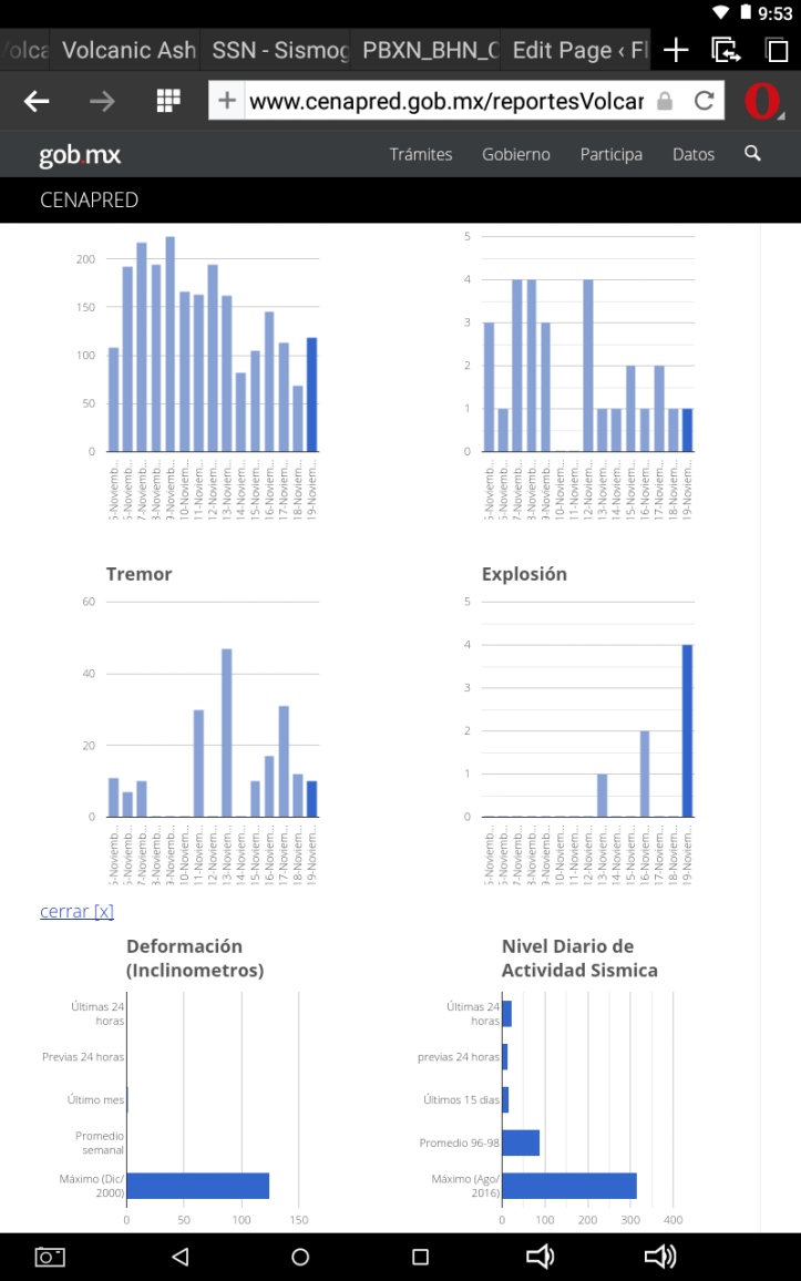
November 18, 2018, 5:46 p.m., Pacific: Right. Let’s review Popo’s activity this afternoon. All my concern, expressed below, is about that unusually long exhaltion about 3/4 of the way through this time-lapse video, which runs from noon to 5:59 p.m., local time.
https://youtu.be/chp8T0uV8IA&rel=0
That one was more powerful, but still a “puff”–not enough force in it to lift up a classic eruption column. And as I mentioned at the time, though you can’t really see it here, it seemed to contain a train of smaller “puffs.”
The video ends with another puff but no more advisories have been issued, and from the webcams Popo just appears to be leaking very light gas/ash at the moment–like it was until it got more active around mid afternoon. The PPIG webicorder is still “rough,” but I don’t see any more quakes/tornillos.
Oddly enough, I find no reports of ashfall in the online news yet. Surely there must have been some. Perhaps everyone is waiting to see what the Colossus of Puebla will do next. The novelty has worn off, and it’s not impossible that today, at some point in the future, could seem like “the good old days.”
Sigh. Very stressful, and the people who live around the volcano as well as the authorities, scientists, planners, and emergency response people all deserve the highest praise for their long-term courage and close attention in the face of this looooong crisis.
6:01 p.m., Pacific: Another one, via the Tlamacas cam, ongoing at the time of writing. Sigh.

7:02 p.m., Pacific: Here’s what that event, which went on for a while, per the embedded videos (see earlier post today), looked like at CENAPRED HQ:
El sistema de monitoreo del #Popocatépetl reporta un evento a las 19:57 h, con una altura aproximada de 800 m y dirección noreste. Es importante mantener el radio de seguridad de 12 km. pic.twitter.com/yjHoKZXlF8
— Oscar Zepeda (@capacapa) November 19, 2018
https://platform.twitter.com/widgets.js&rel=0
At the moment, visibility is good thanks to moonlight and clear (if slightly volcano-polluted) skies, and Popo again is just leaking gas/ash.
November 18, 2018, 1:08 p.m., Pacific: A VAAC advisory went up about an hour ago.
From what I’ve seen on authoritative tweets, Popo began “puffing” occasionally shortly after 11 a.m. local time.
Here is the most impressive-looking event:
A las 12:58 el #Popocatépetl presentó una emisión de gas, vapor de agua y bajo contenido de ceniza. Altura aproximada de 1 km con dirección noreste. pic.twitter.com/2KFoZcHhcv
— Oscar Zepeda (@capacapa) November 18, 2018
https://platform.twitter.com/widgets.js
About half an hour ago, Civil Protection in Puebla tweeted out a warning to residents in some areas about possible ashfall:
Probable caída de cenizas del volcán #Popocatépetl en:
* Santa Clara Ocoyucan
* San Jerónimo Tecuanipan
* Los Cholulas
🔅 Tome precauciones. pic.twitter.com/SBb05q2acF— PC Estatal Puebla (@PC_Estatal) November 18, 2018
https://platform.twitter.com/widgets.js
In case you ever find yourself in this situation, here’s my translation, not verbatim, of the instructions in the poster:
- Don’t do outdoor activities
- Cover nose and mouth with a damp kerchief or face mask
- Protect your pets and their food
- Use eyeglasses and avoid contact lenses to reduce eye irritation
- Clean eyes and throat with clean water
- Protect and remove ashfall from roofs, patios, streets, etc.
- Protect open-air water supplies
- Close windows, cover them, and stay indoors as much as possible
The PPIG webicorder seems to be “roughening up” again, a little bit. (Again, I’m a layperson, this is something I’ve noticed, and I have no idea of its significance to the overall picture.)

At the time of writing (now 1:26 p.m., Pacific), they’ve got the Puebla webcam focused in more on the volcano’s summit:
https://youtu.be/Xv4BCKgfmTA&rel=0
2:07 p.m., Pacific: What I see on that cam just now doesn’t look vulcanian to me, i.e., per my layperson’s understanding of the process, it’s ongoing low-level ash-producing activity of some sort (probably dome building as magma slowly extrudes into the crater), not the sudden contact of magma and ground water leading to an explosion (or “exhalation”).
3:07 p.m., Pacific: This ongoing emission seems to have more muscle behind it, and it is lasting longer than other events I recall, but it isn’t as apocalyptic as it appears in the Puebla webcam, with that dramatic setting sun–check out the Altzomoni webcam, too. Thus far, fortunately, there isn’t enough eruptive force to overcome summit wind speeds.
Screencap:
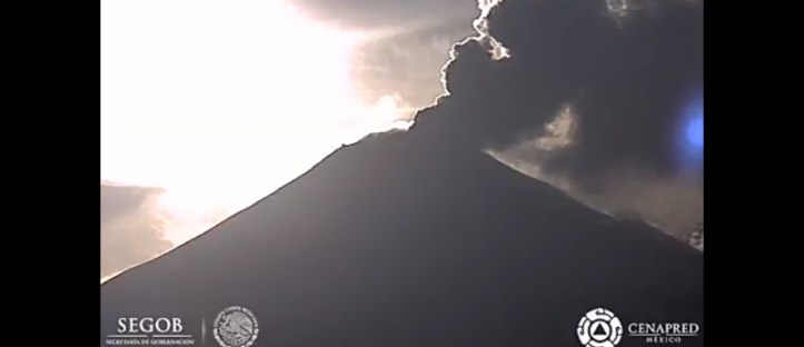
Despite that appearance, if you follow the plume over tens of minutes, you can see there are still discrete “puffs,” just many more of them and more frequently–training. My concern now is that things may escalate. AFAIK, though, CENAPRED hasn’t changed the Yellow Phase 2 alert level.
New VAAC advisory, of course.
3:26 p.m., Pacific: OK, it’s official: still Yellow, Phase 2 (I think this is the Tlamacas cam, though, not Altzomoni):
Desde la cámara localizada en #Atzomoni se presentan diversos eventos del volcán #Popocatépetl a partir de las 12:58 h. El semáforo de alerta volcánico continúa en #AmarilloFase2. pic.twitter.com/5c3dkMleSp
— Oscar Zepeda (@capacapa) November 18, 2018
https://platform.twitter.com/widgets.js
3:38 p.m., Pacific: Activity seems to have diminished; think Dr. Zepeda’s tweet can be taken as the equivalent of an “all clear.” Whew. What next?
Of note, though, the PPIG webicorder still shows some “roughness.” There was also a small quake in the last 15 minutes of the 1600-hour line, but it was not a tornillo. My impression is that the quake happened around the time that this most recent heavy emission slowed down, but I’m not sure.
November 17, 2018, 9:06 a.m., Pacific: Popo was indeed quiet enough not to require a VAAC advisory overnight. The PPIG webicorder has begun showing a few small events in the last couple of hours, though I have no idea of their overall significance.

At the moment, a very light plume of ash is drifting/being pushed up from the crater, nothing more.
And in case you’ve been wondering where all that ash from a “Popo puff” goes, check out the view from Puebla (the second embedded video, above):

November 16, 2018, 5:49 p.m., Pacific: Popo did “pop off” again a few hours ago, prompting another VAAC advisory, but the “roughness” on the PPIG has decreased on the PPIG webicorder this afternoon:

Wonder if we will see a corresponding slow-down (hopefully) or other change in behavior overnight.
In the meantime, here is a serendipitous shot of the westering sun in Popocatepetl’s plume. “Fire mountain,” anyone?
El volcán #Popocatépetl al momento… con fumarola de vapor de agua, gases y ligeras cantidades de cenizas; amarilla debido a la posición del sol. pic.twitter.com/A8SXiiMDSw
— PC Estatal Puebla (@PC_Estatal) November 16, 2018
https://platform.twitter.com/widgets.js
November 16, 2018, 10:40 a.m., Pacific: Not much change from what is, for the volcano I’ve been watching for a few years via online webcams, an increased level of activity.
Most recent tweet from PC_Estatal, about half an hour ago:
Así se vió desde San Andrés Calpan la fumarola de más de 1 km de altura sobre el nivel del cráter y con contenido de vapor de agua y gases: pic.twitter.com/dPhHV5H8gB
— PC Estatal Puebla (@PC_Estatal) November 16, 2018
https://platform.twitter.com/widgets.js
There’s another VAAC advisory from about two hours ago. The alert level hasn’t changed this morning.
Dr. Zepeda’s tweet shows that volcanologists monitoring Popo have much more sensitive equipment than what we can see at the PPIG webicorder!
El #Popocatépetl amanece con un evento a las 6:09 h, con altura aproximada de 800 m y dirección este. El 🚦de alerta volcánico permanece en #AmarilloFase2. pic.twitter.com/S0meJiyqcO
— Oscar Zepeda (@capacapa) November 16, 2018
https://platform.twitter.com/widgets.js
Nobody messes around when 25 million lives and the economic and political heart of a nation are at risk.
Very light ashfall this morning in Puebla State:
Caída de ceniza en Cholula. pic.twitter.com/yrPm6mgZC8
— Volcán Popocatépetl (@Popocatepetl_MX) November 16, 2018
https://platform.twitter.com/widgets.js
Here is the time-lapse video of Popo’s activity over roughly the last six hours. (I’m so old I can remember when it was a big thrill when one vulcanian puff appeared on the webcams in several days’ worth of watching…this new pattern is so not good.)
https://youtu.be/xosma-RxkwE&rel=0
November 16, 2018, 1:58 a.m., Pacific: I’ve had trouble embedding these videos before, but will try it again because at the moment there is something coming off the summit (on the side away from the camera, unfortunately); probably another emission.
https://youtu.be/WV49hBHrlPc&rel=0
Took a screencap of it:
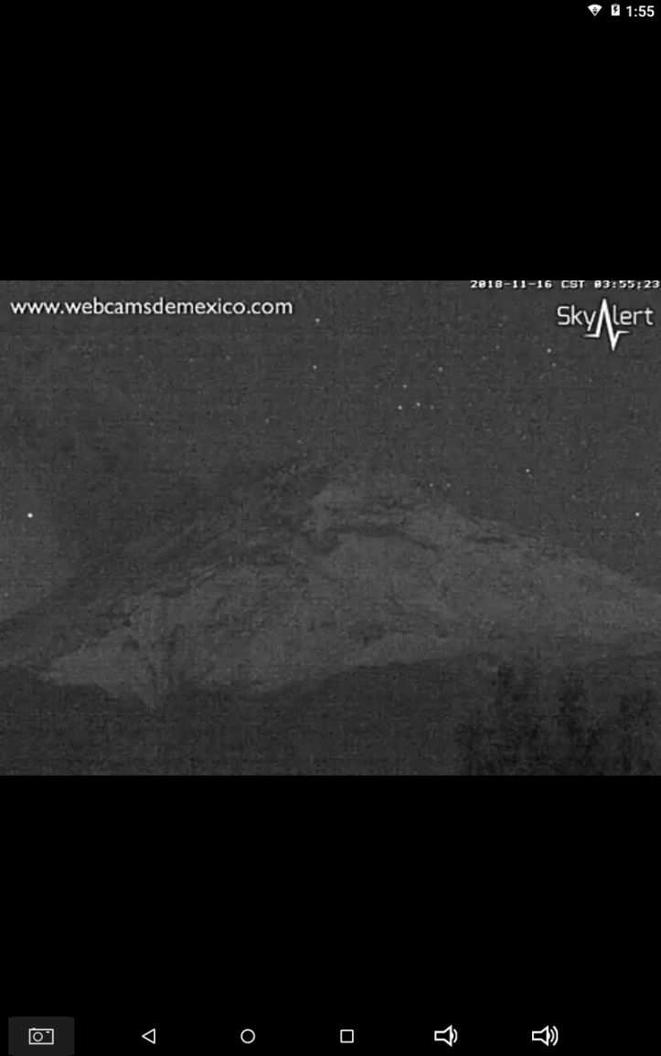
November 16, 2018, 12:42 a.m., Pacific: New VAAC advisory; Popo just erupted, and a somewhat larger quantity of ash, too, judging from the graphic:
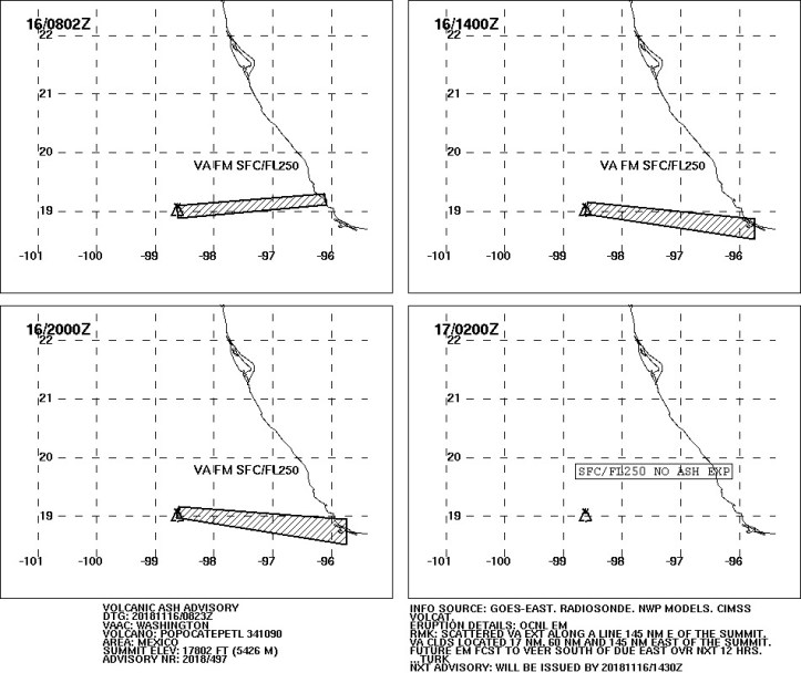
No changes in alert level per the CENAPRED website, which still carries the November 15 daily update, but I’ll bet there are some ashfall reports from this.
I’m going to stay up for another hour or so, because the PPIG webicorder shows that “roughness” hasn’t dropped down. Besides being steady, it’s a little more intense now than it was 24 hours ago. It probably means little in the overall picture, but I’m a little concerned. Will see what, if anything, Popo does next.
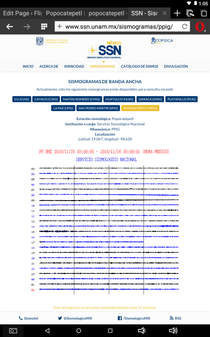
November 16, 2018, 12:30 a.m., Pacific: A late-night check on Don Goyo. No new advisories, but a look at the NOAA/CIMSS volcanic cloud page, linked above, shows continued intermittent emissions. Can’t see much on the webcams; either the moon has set or the volcano is hidden in clouds.
While checking the news (nothing new; no ashfall reports, either), I came across this adorable critter, called a teporingo, that’s small, cute, and tough enough to live only in the high country of the Trans-Mexican Volcanic Belt, including the flanks of Popocatepetl, per this story (Spanish).

I’ll be thinking of teporingos now every time I look through the webcam at Popocatepetl’s majestic slopes.
November 15, 2018, 8:34 p.m., Pacific: Think my webcam screencap almost three hours ago caught the tail end of this:
Explosión en el volcán #Popocatépetl a las 19:48 h.
[Cámara Amecameca de #WebcamsdeMéxico]. pic.twitter.com/K8IthhEx4k— PC Estatal Puebla (@PC_Estatal) November 16, 2018
https://platform.twitter.com/widgets.js
At present, there is a new VAAC advisory but only for intermittent emissions now.
Nevertheless, the PPIG webicorder shows very low-level “roughness”–not a technical term, but I’ve noticed it often occurs in conjunction with ash emissions. I have no idea why, because the exhalations, explosions, and most VT quakes CENAPRED mentions don’t seem to show up on it.
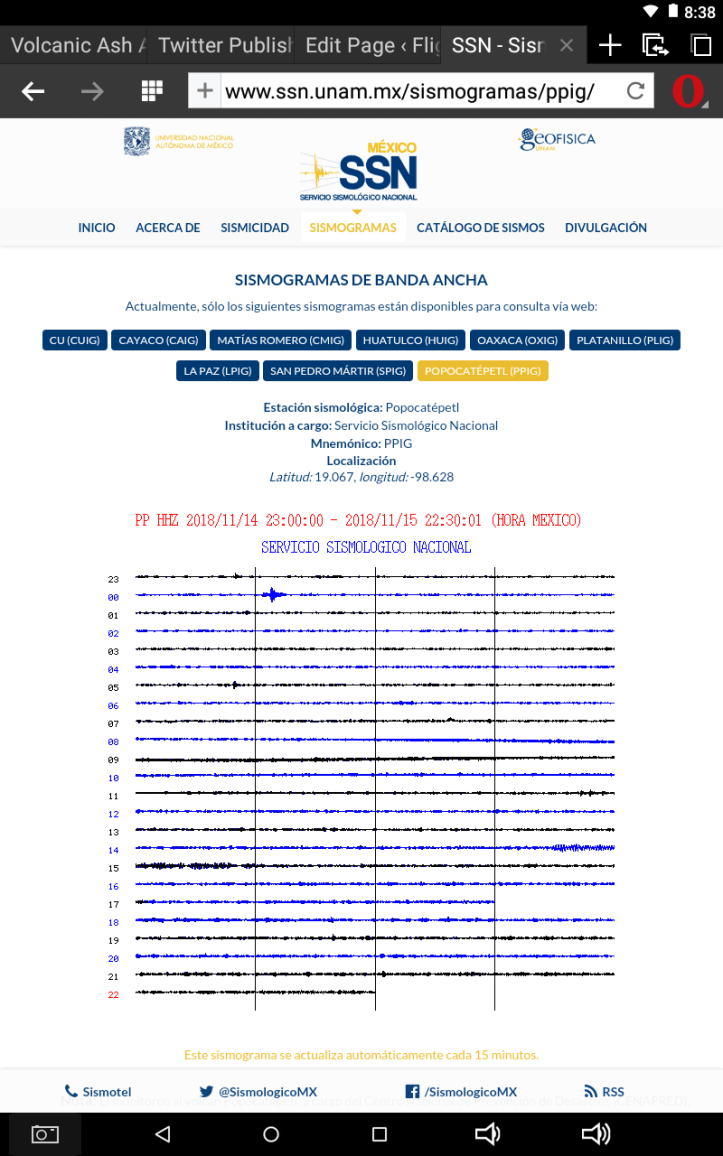
That Puebla Civil Protection account (PC_Estatal) tweeted a couple of reminders to people about bug-out bags (“mochilas”–emergency evacuation kits) and family emergency plans: nonspecific, nothing volcano related, but such reminders are always helpful.
November 15, 2018, 5:53 p.m., Pacific: Washington VAAC notes ongoing ash emissions within the last two hours.
Looks like they’re still ongoing, per the webcam view under the moonlight; no incandescence, though.
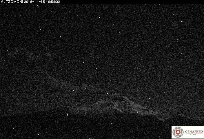
November 15, 2018, 3:54 p.m., Pacific: Some vulcanian events; unfortunately, this video ends in the middle of one of them:
https://youtu.be/rt9f-aJ5rnQ&rel=0
Of note, today’s update says that incandescence was noted at the summit last night; this used to be fairly common, but not for many weeks now. Lava has reached the surface. Is it building a new dome?
November 15, 2018, 9:19 a.m., Pacific: With its snowy mantle, the Colossus of Puebla is majestic from almost all angles . . .
. . . at dawn:
Así amaneció el volcán #Popocatépetl: pic.twitter.com/uFTsrgOdTu
— PC Estatal Puebla (@PC_Estatal) November 15, 2018
https://platform.twitter.com/widgets.js
. . . and at present:
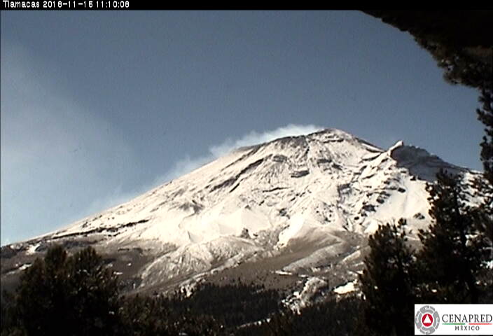
It is still moody, though, as events a couple hours ago show (no VAAC advisories since November 12th):
Desde la cámara de #Alzomoni, se observa el evento que se presentó en el volcán #Popocatépetl a las 8:53 h, con dirección noreste. El #CENAPRED recomienda continuar con el radio de seguridad de 12 km y seguir las indicaciones establecidas por @PcSegob. pic.twitter.com/uRQgC9onXi
— Oscar Zepeda (@capacapa) November 15, 2018
https://platform.twitter.com/widgets.js
November 13, 2018, 7:12 p.m., Pacific: See updated link above to CENAPRED’s updates in English; as long as it’s viable, I won’t repost them here. Of note, though, today they reported 47 minutes of harmonic tremor and 1 explosion.
There have been no VAAC advisories on the volcano since yesterday.
El volcán #Popocatépetl en las últimas 24 h presentó:
▫️162 exhalaciones
▫️1 explosión hoy a las 05:32 con emisión de fragmentos incandescentes.
▫️1 sismo VT hoy a la 07:57 h, M= 1.5.
▫️47 minutos de tremor armónico.
[Fuente: #CENAPRED]. pic.twitter.com/PLucrI8l1D— PC Estatal Puebla (@PC_Estatal) November 13, 2018
https://platform.twitter.com/widgets.js

November 12, 2018, 10:30 a.m., Pacific: Just the same thing over and over again each day, but this is an elevated activity level for Popo, compared to recent years. And no one knows what it will do in the next minute, hour, day, week, month, or year–not good, next to one of the largest population centers on Earth/concentrated heart of a nation’s economic and political resources.
Yes, there is a VAAC advisory up. And here’s today’s update:
November 12, 11:00 h (November 12, 17:00 GMT)
In the last 24 hours, the Popocatepetl volcano monitoring system recorded 194 low intensity exhalations, accompanied by steam and gas and small amounts of ash . . . The most important event was recorded today at 08:49 . . . Additionally four volcanotectonic earthquakes were recorded yesterday at 21:01 and 21:03 h, and today at 07:29 and 09:14 h, with magnitude of 2.7, 1.8, 1.9 and 1.6, respectively.
At the moment of this report we cannot see the volcano due to claoudy conditions, but this morning we can see the emission of volcanic gases in a northeasterly direction . . .
CENAPRED emphasizes that people SHOULD NOT go near the volcano, especially near the crater, due to the hazard caused by ballistic fragments . . . and in case of heavy rains leave the bottoms of ravines by the danger of landslides and debris flows.
The Volcanic Traffic Light Yellow Phase 2.
Here’s more information on the location of those VT earthquakes:
Así mismo, se registraron cuatro sismos volcanotectónicos, ayer a las 21:01, 21:03 h y hoy a las 07:29 y 09:14 h, con magnitud de 2.7, 1.8, 1.9 y 1.6. El CENAPRED exhorta a NO ACERCARSE al volcán y sobre todo al cráter por el peligro que implica la caída de fragmentos balísticos. pic.twitter.com/iE38XUPewn
— Oscar Zepeda (@capacapa) November 12, 2018
https://platform.twitter.com/widgets.js
November 11, 2018, 12:22 p.m., Pacific: Some explosions overnight, and this morning an episode of continuous, light ash emission that has a VAAC advisory in place at the moment; also 30 minutes of tremor, per CENAPRED.
https://youtu.be/YS1Ac1Iz8AE&rel=0
One of the overnight explosions:
El volcán #Popocatépetl en las últimas 24 h presentó:
⚪ 163 exhalaciones de vapor de agua, gases y ligeras cantidades de ceniza.
⚪ 30 minutos de tremor.
Fuente [#CENAPRED]. pic.twitter.com/lQpbw00FUX— PC Estatal Puebla (@PC_Estatal) November 11, 2018
https://platform.twitter.com/widgets.js
Per the graphic and update, though, no explosions happened; apparently CENAPRED has redefined the volcanological meaning of the word “explosion” in reference to Popocatepetl–understandable, given this volcano’s many “exhalations” (something not seen in many other volcanoes). Wonder what counts as an explosion here now:

November 10, 2018, 10:26 a.m., Pacific: Popocatepetl is restless this morning. See Dr. Zepeda’s tweets for images, including this one (note that alert level is still Yellow, Phase 2):
2. El #semaforo de #alerta #volcánica se encuentra en #amarillofase2. Video de la cámara ubicada en la estación #Altzomoni. pic.twitter.com/SDjukmoN6e
— Oscar Zepeda (@capacapa) November 10, 2018
https://platform.twitter.com/widgets.js
At 1213 UTC, about six hours ago, Washington VAAC reported an eruption; when I accessed their page shortly after 1800 UTC, it looked like they had just posted another advisory but it gave a 404 HTTP response and now it’s gone–they are still apparently watching the volcano closely, though in the webcams it appears back to business as usual, with lots of steam clouds (though not a train of them). Update: Now it’s up again–an emission at 1608 UTC.
None of the morning’s emissions showed up on the PPIG webicorder. Per CENAPRED’s update this morning:
November 10, 11:00 h (November 10, 17:00 GMT)
In the last 24 hours, the Popocatepetl volcano monitoring system recorded 166 low intensity exhalations, accompanied by steam and gas and small amounts of ash. The most important ones, yesterday at 18:40 h . . . and today at 5:45 h . . . 7:38 h . . . and 8:23 h . . .
At the moment of this report the visibility is reduced due to clouds; however, at previous hours an emission of steam and gas was observed being dispersed to the southeast . . .
CENAPRED emphasizes that people SHOULD NOT go near the volcano, especially near the crater, due to the hazard caused by ballistic fragments . . . and in case of heavy rains leave the bottoms of ravines by the danger of landslides and debris flows.
The Volcanic Traffic Light Yellow Phase 2.
Update at 10:44 a.m., Pacific: They apparently aren’t classifying that as an explosion, though it looked like one. I have found an excellent time-lapse video that someone put together from the webcam feeds.
Wait for it:
https://youtu.be/ZFB0oO2qtxM&rel=0
No wonder there were no ashfall reports–it dissipated quickly. This sort of behavior must be very stressful for the people around the volcano, though. Not to mention the people monitoring it!
November 9, 2018, 7:22 p.m., Pacific: Popo, about three hours ago:
A las 18:40 el volcán #Popocatépetl tuvo una exhalación con altura aproximada de 2 km, la parte alta de la emisión se desplaza hacia el sureste. El🚦de alerta volcánica permanece en #AmarilloFase2. El #CENAPRED exhorta a NO ACERCARSE al volcán y sobre todo al cráter. pic.twitter.com/HbGS6yjXH4
— Oscar Zepeda (@capacapa) November 10, 2018
https://platform.twitter.com/widgets.js
Washington VAAC issued an advisory on the volcano an hour ago. Given the time delay, I’m thinking there might have been another exhalation, but it’s too dark to tell; also, at the moment, I can’t get the webcams to display an image.
November 9, 2018, 12:16 p.m., Pacific: Highest number of exhalations in the last month, over the past 24 hours. Deformation is down; some seismic activity. They don’t mention LP quakes (which is what a tornillo is) or tremor in this morning’s report. Here’s the graphic:

November 9, 2018, 9:50 a.m., Pacific: The update isn’t up yet, but here is what they call a “postal”–Popo from a nearby town this morning:
El #Popocatépetl visto desde San Nicolás de los Ranchos: pic.twitter.com/z51wCxRa8T
— PC Estatal Puebla (@PC_Estatal) November 9, 2018
https://platform.twitter.com/widgets.js
Despite the tranquil scene, Dr. Zepeda tweets that Popo has had at least two exhalations this morning (small ones, without unusual colors). No VAAC advisories since early on the 7th, and the PPIG webicorder has no more unusual things on it. There have been a couple of “bumps” this morning; the first might have coincided with the second exhalation (such coincidence is rare, I’ve found), but the second happened later.
The new webcam froze about half an hour ago and now it’s blank; it’s quite close to the summit, in challenging conditions, and it’s not surprising that there are technical problems shortly after installation. (Update, around midday: It’s working again, but the steam clouds Popo is huffing out are obscuring the summit.)
From yesterday:
¡Entérate! El sistema de monitoreo del #volcán #Popocatépetl, integró una nueva cámara generando mayor información para la observación de la actividad volcánica. Se consolida la capacidad de instrumentación y monitoreo del #CENAPRED. pic.twitter.com/KhOBreG2Sc
— Oscar Zepeda (@capacapa) November 8, 2018
https://platform.twitter.com/widgets.js
I’ll bet the thought of volcanologists ascending the Colossus of Puebla to install that camera has inspired at least one young person today to enter this career field. That’s wonderful!
November 8, 2018, 7:59 p.m., Pacific: All seems per the current baseline except this–I wonder what that last activity was, about an hour ago. Could it be a tornillo? It sort of resembles the ones shown in this paper, though it doesn’t have the classic screw-like shape.

If not a tornillo, it certainly looks like harmonic tremor (to this layperson, anyway).
Here are graphics from this morning’s update: deformation has not decreased, and there have been no explosions since those inky-black ones the other day. Wonder what Popo is up to now. . .

November 8, 2018, 3:50 p.m., Pacific: Something’s going on up there this afternoon, but at a very low level:

There is no VAAC advisory and the view is rather clear at the moment:

I’m guessing those are all volcano-generated steam clouds.
Not much change in this morning’s update; here is a summary:
El volcán #Popocatépetl en las últimas 24 h presentó:
♾ 194 exhalaciones de vapor de agua, gases y ligeras cantidades de ceniza.
♾ 4 sismos VT; Dos ayer a las 12:48 y 22:14 h, M= 1.2 y 1.5 y dos hoy a las 01:38 y 01:42 h, M= 1.3 y 2.8.
[Fuente: #CENAPRED]. pic.twitter.com/2aElJB1lny— PC Estatal Puebla (@PC_Estatal) November 8, 2018
https://platform.twitter.com/widgets.js
November 7, 2018, 9:53 a.m., Pacific: Yesterday evening’s ash emission did eventually get a VAAC advisory, but they have given the volcano an all-clear overnight. This morning, CENAPRED’s cameras see this:
Desde la cámara del #CENAPRED ubicada en #Altzomoni se visualiza en el volcán #Popocatépetl, la constante emisión de gas y vapor de agua con dirección hacia el sureste. En el video se observan dos direcciones de viento a diferentes alturas. El semáforo continúa en #AmarilloFase2. pic.twitter.com/5yOgpPBsSN
— Oscar Zepeda (@capacapa) November 7, 2018
https://platform.twitter.com/widgets.js
My translation of this roughly one-hour-old tweet: “From the Altzomoni camera, the constant emission of gas and water vapor heading southeast. Two wind directions at different heights are shown in the video. The traffic signal alert continues at Yellow Phase 2.”
Obviously there is a little ash in the plume, too, but none of that black inky stuff from earlier this week, and not enough to trigger another VAAC advisory. Popo has done and can keep doing this sort of stuff for decades, but one wonders what is going on inside the volcano now. We can only watch and wait . . .
November 6, 2018, 6:49 p.m., Pacific:
Actividad del volcán #Popocatépetl al momento. Fumarola de vapor de agua y gases con altura aproximada de 1,500 m sobre el nivel del cráter…
desde #Huejotzingo. pic.twitter.com/q3iZeMDJ0p— PC Estatal Puebla (@PC_Estatal) November 6, 2018
https://platform.twitter.com/widgets.js
Interestingly, the PPIG webicorder showed some of that “chuffing” behavior but it stopped well before 1709. There are tweets out there of later activity, too, but this live action is nice. (Correction: I got that 1709 from one of the other tweets; the time of this video is unknown.)
Here’s the webicorder:

No VAAC advisory; no change in the alert status; no reports of ashfall. You can just make out the summit outline now on the Tlamacas webcam, but no details; there is no incandescence, either.
November 6, 2018, 11:53 a.m., Pacific: Deformation slightly elevated over the last 24 hours; no more explosions. Lots more exhalations, though.

El volcán #Popocatépetl en las últimas 24 horas presentó:
✴ 192 exhalaciones de vapor de agua, gases y ligeras cantidades de ceniza.
✴ 1 sismo VT hoy a las 01:23 h, M= 1.8
✴ 7 minutos de tremor.
[Fuente: #CENAPRED]. pic.twitter.com/zxym3EARIA— PC Estatal Puebla (@PC_Estatal) November 6, 2018
https://platform.twitter.com/widgets.js
November 5, 2018, 12:54 p.m., Pacific: Yes, the deformation did go down after those two explosions. Now, no more explosions and slightly increased tremor.
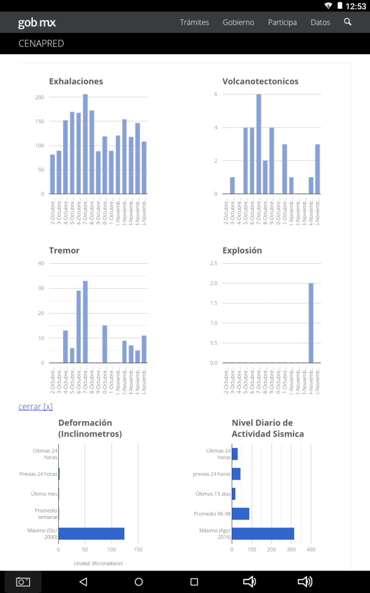
El volcán #Popocatépetl en las últimas 24 h presentó:
⏺ 108 exhalaciones.
⏺ 11 minutos de tremor.
⏺ 3 sismos VT ayer, a las 12:26, 12:28 y 12:43. M= 3.2, 2.0 y 1.9.
[Fuente: #CENAPRED]. pic.twitter.com/qpMUxq3zHG— PC Estatal Puebla (@PC_Estatal) November 5, 2018
https://platform.twitter.com/widgets.js
November 4, 2018, 4:28 p.m., Pacific: Was able to get the graphics:

Will see if the deformation goes down again after the explosions. At the moment, you can dimly see the summit in the fading sunset, and apparently there is just a steam plume.
Was thinking about those inky black clouds yesterday and realized, even though I’m no geochemist, that sulfur can also look black in solution; wonder if that was ash, as per Dr. Zepeda, or perhaps a phreatomagmatic explosion of a brine pocket? If so, wouldn’t that mean that magma is very near the summit crater?
Yet there is no incandescence lately at night when the summit is visible.
Just speculating.
November 4, 2018, 9:44 a.m., Pacific: Those two ash emissions were actually the first two explosions at Popocatepetl in a while.
En las últimas 24 horas, el monitoreo del #Popocatépetl identificó 147 exhalaciones. Se presentaron dos explosiones a las 16:38 y 17:27 h con una altura aproximada de 1.5 y 1.6 km. Además, se registró un evento volcanotectónico hoy a las 00:51 h con magnitud preliminar de 2.0. pic.twitter.com/FHbTLem5Ue
— Oscar Zepeda (@capacapa) November 4, 2018
https://platform.twitter.com/widgets.js
Per Google Translate:
In the last 24 hours, the monitoring of Popocatépetl identified 147 exhalations . There were two explosions at 16:38 and 17:27 with an approximate height of 1.5 and 1.6 km. In addition, a volcanotectonic event was recorded today at 00:51 h with a preliminary magnitude of 2.0.
The volcano is hidden clouds on the webcam, and I still can’t find any news about ashfall.
November 3, 2018, 6:33 p.m., Pacific: Not much change in today’s update, but per Dr. Zepeda, Popocatepetl had a very-high-content ash emission about four hours ago:
Secuencia del evento de largo periodo (LP) en el #volcán #Popocatépetl a partir de las 16:38 h, con alto contenido de ceniza y dispersión en dirección noreste.
En caso de caída de ceniza:
1⃣Cubrir nariz y boca con pañuelo húmedo o cubreboca
2⃣Limpiar ojos y garganta con agua pura pic.twitter.com/8yX7EueQ9w— Oscar Zepeda (@capacapa) November 4, 2018
https://platform.twitter.com/widgets.js
Look how dark that cloud is, compared to the typical emissions! Apparently the emission was accompanied by a long-period (LP) earthquake (these are produced by magma movement, per MTU). No VAAC advisory posted on the website since November 1st. This cloud went to the northeast, per Dr. Z., but per Puebla PC, it went northwest, towards Mexico City. Skyalert tweets that there have been various emissions this afternoon and they went toward Puebla.
Anyway, a little earlier today Dr. Zepeda tweeted:
El #Volcán #Popocatépetl registró actividad a las 16:40 hrs. emitiendo una fumarola de 1,500 metros con contenido de ceniza y se dirige al Noreste. El🚦de alerta volcánica permanece en #AmarilloFase2. Sigue las recomendaciones de @PcSegob y respeta el radio de seguridad de 12Km. pic.twitter.com/gyvJ3KFNQZ
— Luis Felipe Puente (@LUISFELIPE_P) November 3, 2018
https://platform.twitter.com/widgets.js
And per Puebla PC, there was an emission almost an hour later:
A las 17:29 h, el volcán #Popocatépetl emitió otra fumarola con contenido de ceniza que se elevó a más de 1,200 m sobre el nivel del cráter y se dispersó hacia el noroeste, es decir, hacia el #EdoMéx: pic.twitter.com/dUVd5Eysge
— PC Estatal Puebla (@PC_Estatal) November 4, 2018
https://platform.twitter.com/widgets.js
Now it’s dark, of course, but you can make out the summit outline. No incandescence is evident.
I can find no news reports of ash fall from these emissions. Wonder why it was so dark? Mafic magma??? That dark, Hawaiian-style stuff isn’t associated with arc volcanoes like Popocatepetl, which is typically on the felsic (light-colored) end of the igenous rock spectrum.
One last note: the events didn’t show on the PPIG webicorder. They often don’t; the volcanologists, of course, have lots of other equipment.
November 2, 2018, 1:13 p.m., Pacific: Nothing much new in the updates from yesterday and today. Here is today’s graphic, showing deformation up a bit, no explosions yet, and other parameters within their typical levels lately.

The volcano is socked in on the webcams at the moment, but here is a lovely image of it from earlier today:
Ult 24 h:
•154 exhalaciones.
•0 explosiones.
•0 sismos VT.
•9 min de tremor.«🚦Amarillo 2» pic.twitter.com/C41hkWUM7m
— Volcán Popocatépetl (@Popocatepetl_MX) November 2, 2018
https://platform.twitter.com/widgets.js
October 31, 2018, 8:26 p.m., Pacific:
A las 18:17 h, el volcán #Popocatépetl emitió una fumarola con contenido de ceniza.
[Cámara Amecameca/#WebcamsdeMéxico]. pic.twitter.com/HiC9RLpeBq— PC Estatal Puebla (@PC_Estatal) November 1, 2018
https://platform.twitter.com/widgets.js
No VAAC advisory–it was light. No sign on the PPIG webicorder, either. The webcams that are clear show a dark summit but there appears to be a little rising fume of some sort up there.
No dramatic changes, but Popo seems a little different to me. Can’t put my finger on it, though. Just slightly different behavior, I guess. Not the “good ole Popo,” lazily puffing away, that I’ve been watching online for a few years; more like a volcano that is starting to seriously think about getting down to business. The volcanologists have a much better view, though, and they are keeping the alert level at Yellow Phase 2 and waiting . . . and taking cool time-lapse videos. This is from today; the puff shown above exited on the other side of the volcano. You can see how light it was. Gorgeous video, too.
#ConociendoalPopocatépetl, segundo volcán más activo de México y el de mayor riesgo por su historial de erupciones explosivas documentadas en el registro estratigráfico y número personas que habitan en sus cercanías. Memoria técnica del mapa de peligros del volcán Popocatépetl. pic.twitter.com/ZzBTAdCyrE
— Oscar Zepeda (@capacapa) November 1, 2018
https://platform.twitter.com/widgets.js
Per Google Translate:
Popocatépetl, the second most active volcano in Mexico and the one with the highest risk due to its history of explosive eruptions documented in the stratigraphic record and number of people living in its vicinity. Technical report of the hazard map of the Popocatépetl volcano.
There is no link; I think the video is the technical report referred to, or else he means this and this (both in Spanish).
October 31, 2018, 5:47 p.m., Pacific: It probably doesn’t matter at all, but I note that this morning’s ash emission, unlike yesterday’s, was followed by a few signals, as if it wasn’t quite done or was trying to restart.
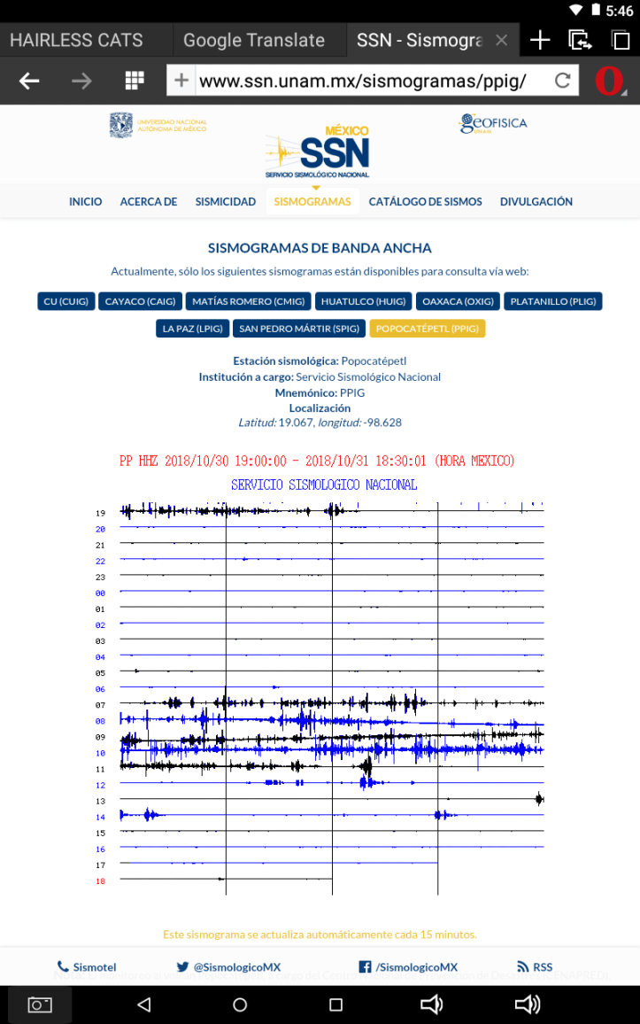
October 31, 2018, 2:23 p.m., Pacific: Another episode on the PPIG webicorder, early this morning, and this time it got a VAAC advisory.
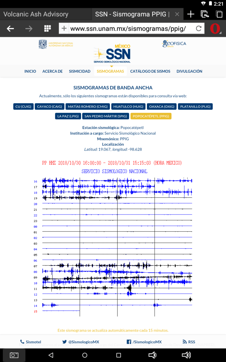
The ash has dissipated now, per Washington VAAC, and on the webcam Popo appears to be chuffing steam again–its summit is hidden by curly white clouds that probably aren’t weather related.
And per CENAPRED (via Google Translate):
In the last 24 hours, through the monitoring systems of the Popocatépetl volcano, 89 exhalations were identified. During most of the time covered by this report, visibility was not available; however, those exhalations that could be seen were accompanied by water vapor, gas and light amounts of ash. In addition, three vulcanotectonic earthquakes were recorded, the first two yesterday at 18:37 and 19:34, with magnitudes of 2.7 and 1.5, respectively, and the third this morning at 9:55, with a magnitude of 1.5. During the night there was visibility towards the volcano and no incandescence was observed.
At the time of this report there is no visibility to the volcano, but earlier today there was an emission of water vapor, gas and light ash content dispersed to the northeast.
The CENAPRED urges NOT TO APPROACH the volcano and especially the crater, for the danger that involves the fall of ballistic fragments and in case of heavy rains away from the bottoms of ravines by the danger of landslides and mudflows.
The Popocatepetl Volcanic Alert Traffic Light is Yellow Phase 2.
Odd that there is ash but no incandescence (see image below from yesterday, too–very dark summit).
Meanwhile, life goes on. At the fair in nearby Tlaxcala, per this news story (Spanish), a
Day of the Dead offering from secondary school students to Popocatepetl and its neighbor Iztaccihuatl has won second prize.
Here is an image of the Tlaxcala fair from 2015.

Thanks to volcanic ash, the soil around most volcanoes is very fertile. That’s basically why people live so close to these dangerous fire mountains everywhere on Earth.
October 30, 2018, 8:06 p.m., Pacific: Well, whatever was going on has now ceased, and PPIG is back to its typical almost flat line. There isn’t much moonlight, but the Tlamacas webcam now shows a steam plume rising–typical activity for Don Goyo.
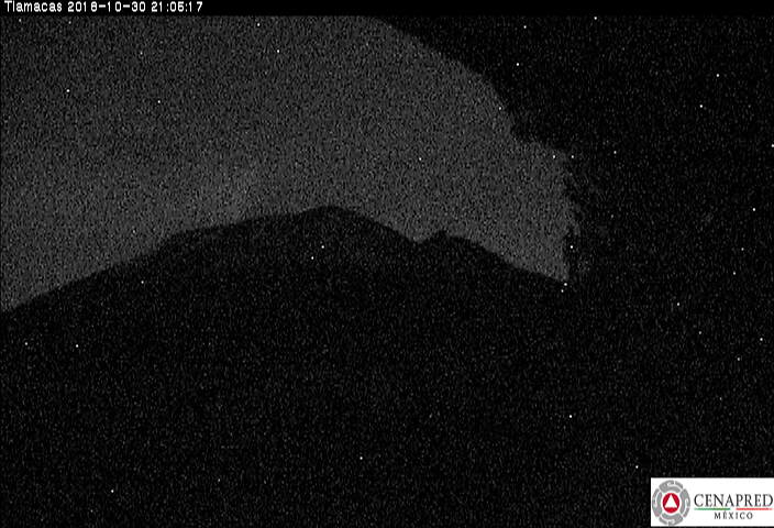
October 30, 2018, 4:52 p.m., Pacific: That “chuffing” continues . . .
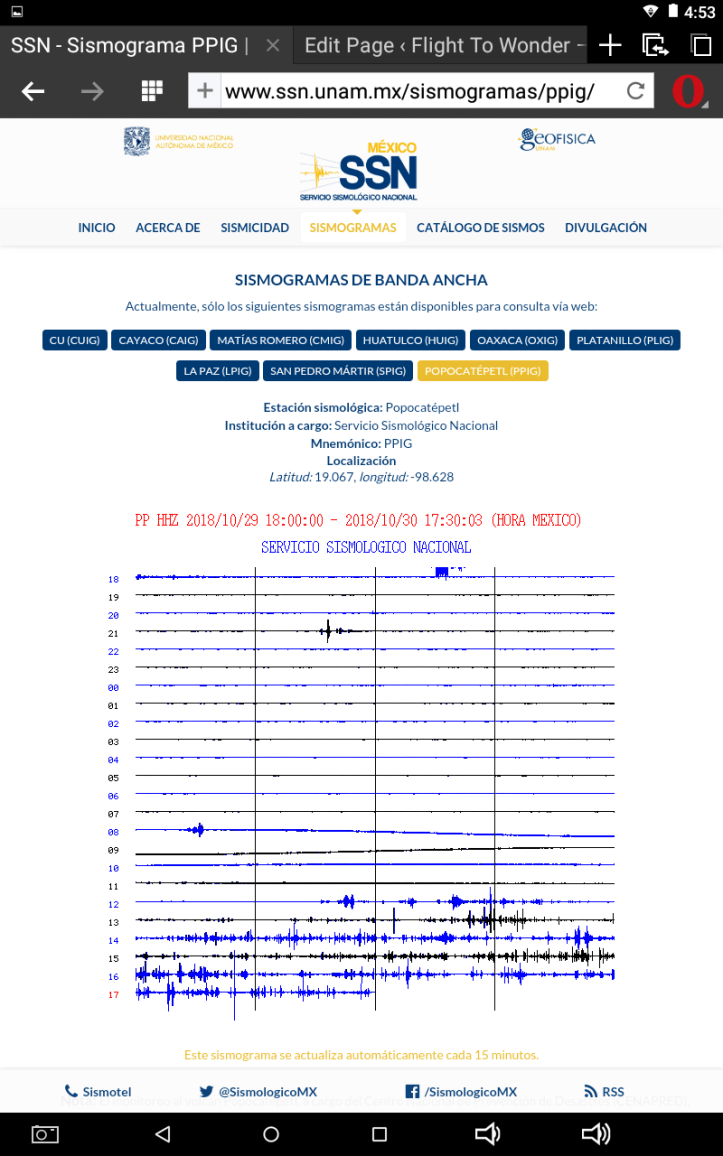
. . . and the clouds have cleared, showing what looks to me like a low-level plume of very light ash (no VAAC advisory or change in alert level found).
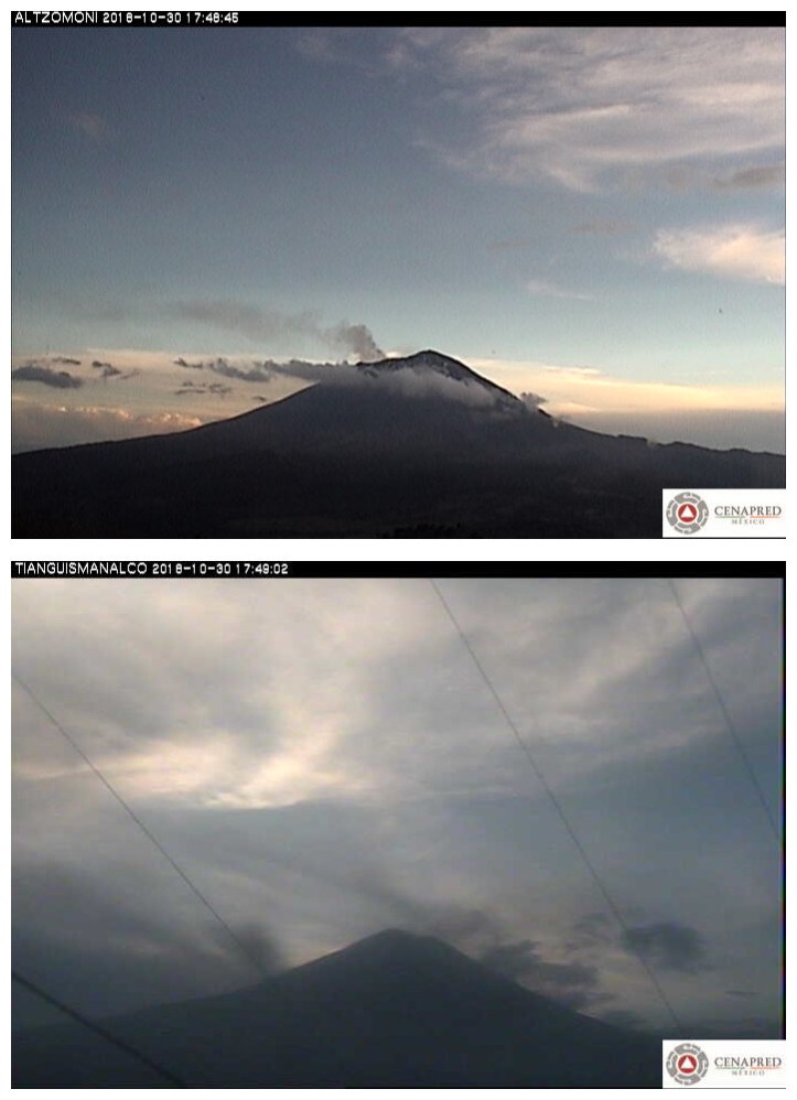
October 30, 2018, 12:31 p.m., Pacific:
El volcán #Popocatépetl en las últimas 24 h presentó:
⚪ 119 exhalaciones de vapor de agua, gases y ligeras cantidades de ceniza.
⚪ 15 minutos de tremor.
[Fuente: #CENAPRED]. pic.twitter.com/n9cP2NkAtk— PC Estatal Puebla (@PC_Estatal) October 30, 2018
https://platform.twitter.com/widgets.js
119 exhalations of water, gases (per today’s full update page, SO2 outgassing over the last 24 hours is low compared to earlier phases of the eruption), and light quantities of ash (no VAAC advisories since yesterday), and 15 minutes of tremor.
Per the PPIG webicorder, Popo is doing something at the moment, but clouds hide the summit–I suspect at least some of those clouds are volcanigenic and the Colossus of Puebla is chuffing out huge quantities of steam. There is no ash plume from the long-distance cam view, relatively clear, at Tianguismanalco.

October 29, 2018, 11:33 a.m., Pacific: No mention related to the signal I noted yesterday–think it was a small landslide/debris flow.
October 29, 11:00 h (October 29, 17:00 GMT)
In the last 24 hours, through the Popocatepetl volcano monitoring system was recorded, 88 low intensity exhalations, accompanied by steam, gas and ash. The most important exhalation was presented today at 09:44 h . . . Additionally, four volcanotectonic events were recorded, one yesterday at 18:20 and the rest today at 04:15, 04:36 and 07:13 h, with a magnitude calculated of 1.8, 3.0, 2.1, and 2.6, respectively. During the night, there was no visibility towards the crater of the volcano, due to the weather conditions.
At the moment of this report is possible to observe that the emissions of steam, gas and ashes are dispersed to the north-west direction . . .
CENAPRED emphasizes that people SHOULD NOT go near the volcano, especially near the crater, due to the hazard caused by ballistic fragments . . . and in case of heavy rains leave the bottoms of ravines by the danger of landslides and debris flows.
The Volcanic Traffic Light Yellow Phase 2.
Those ashes may be remnants of a small emission about five hours ago that got a VAAC advisory.
What concerns this layperson a little is that the volcano hasn’t had an explosion for a while; this is a change in its recent activity level. Ordinarily that would be great news, but other parameters haven’t dropped.

The deformation is a wee bit elevated, too, though nowhere near where it was at some earlier phases of this long-lasting eruption.
Does any of this mean something? I have no idea. But that, combined with what probably was a landslide yesterday, makes me watch it closer. Given the weather, the landslide would be expected. But given Popo’s history and currently elevated activity, I think this “smoking mountain” deserves (and surely is getting from scientists and emergency planners) even closer scrutiny and watchful waiting right now.
October 28, 2018, 7:35 p.m., Pacific: I didn’t include the CENAPRED update today because it was basically unchanged. However, just noticed this interesting signal on the PPIG webicorder, from a few hours ago:
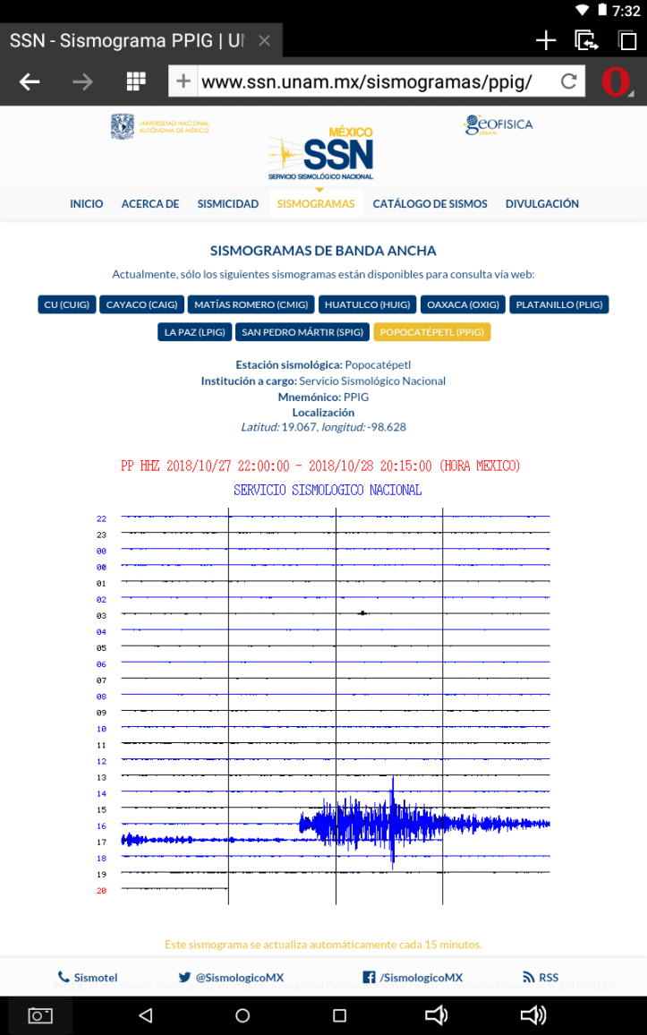
There is no VAAC advisory since the 24th, no mention of anything unusual in the Twitter feeds I check because they always are informative, and the pattern looks a little weird–I’m a layperson and can say no more than that. It might have been somebody moving something near the seismometer for a while or it’s just possibly a signal from the M6.1 in El Salvador this afternoon around the same time, although, again, it’s kind of a weird-looking, stretched out signal.
A landslide or debris flow on the volcano’s flanks, perhaps? There certainly is enough rain for it, and landslides are happening in other parts of this general region.
Hopefully, CENAPRED, Dr. Zepeda, or somebody else knowledgeable will have something to say about it by tomorrow morning’s update. Anyway, it seems clear that, although the volcano’s summit is shrouded in clouds, Popo has not had a sudden increase in eruptive activity.
October 27, 2018, 11:46 a.m., Pacific:
Las últimas 24 horas, el monitoreo del #Popocatépetl identificó 206 exhalaciones acompañadas de vapor de agua y gas. Se registraron seis sismos volcanotectónicos con magnitudes de 2.2, 2.1, 2.2, 1.8, 2.8 y 1.8 respectivamente y un acumulado de 33 min de tremor de baja amplitud. pic.twitter.com/W9juTmA4wq
— Oscar Zepeda (@capacapa) October 27, 2018
https://platform.twitter.com/widgets.js
Many scientific terms are similar in both English and Spanish; “seis” is “six”; “baja” means “low.”
Dr. Zepeda also tweets that there was a swarm of four earthquakes a little east of Tlamacas, apparently quite separate from the seismic activity inside Popocatepetl. That would be what showed up on the webicorder yesterday (scroll down to yesterday’s update here); I think it’s that large blue circle on the left in these diagrams–not underneath the volcano.
2⃣ Localización de los #VTs registrados en el volcán #Popocatépetl las últimas 24 horas. El #sismo más importante se registró a las 23:51 de ayer con M2.8 y Pf=5.3 (evento 49). También se registró un enjambre de 4 sismos, ubicados entre 2 y 3 km al este de Tlamacas. pic.twitter.com/K4pVDsjons
— Oscar Zepeda (@capacapa) October 27, 2018
https://platform.twitter.com/widgets.js
Today’s graphic shows no explosions:

October 26, 2018, 12:29 p.m., Pacific: The PPIG webicorder is interesting . . .

. . . but I don’t see those four events addressed in today’s update (nor are there any VAAC advisories up; the volcano appears to be steaming heavily, from what little the webcams show at present):
October 26, 11:00 h (October 26, 16:00 GMT)In the last 24 hours, through the monitoring systems of the Popocatépetl volcano, 168 exhalations . . . accompanied by steam and gas were recorded. It was registered four volcanotectonic earthquakes yesterday at 14:56 h, 15:13 h, 21:25 h and 22:29 h with magnitud of 1.5, 2.3, 1.5 and 1.2, also were registered 29 minutes accumulated in this episode of low amplitud tremor.
In most of the time we could see the volcano. At the time of this report, we have visibility to the crater . . . and it has a light emission of steam and gas to the nor-noreast side.
CENAPRED emphasizes that people SHOULD NOT go near the volcano, especially near the crater, due to the hazard caused by ballistic fragments . . . and in case of heavy rains leave the bottoms of ravines by the danger of landslides and debris flows.
The Volcanic Traffic Light Yellow Phase 2.
Today’s graphics show that Popo has been doing a little bit of everything except explosions recently (though none approaching what it has done earlier in this eruption)–perhaps it’s building up to one of its low-level (hopefully) explosions, if it didn’t already happen, per the webicorder.

October 25, 2018, 1:23 p.m. Pacific: No VAAC advisories since yesterday; today’s update is not much changed from yesterday’s, with a little more seismicity and a little less tremor.
El volcán #Popocatépetl en las últimas 24 h presentó:
🔺 170 exhalaciones de vapor de agua y gases.
🔺 4 sismos VT, M= 1.8, 1.6, 1.3 y 1.1.
🔺 6 minutos de tremor de baja amplitud.
[Fuente: #CENAPRED]. pic.twitter.com/9BaFtpZn16— PC Estatal Puebla (@PC_Estatal) October 25, 2018
https://platform.twitter.com/widgets.js
October 24, 2018, 10:34 a.m., Pacific: One explosion overnight and a VAAC advisory, breaking a week without ash emissions. At the moment, Popo is steaming away in the webcams.
A las 3:26 horas el volcán #Popocatépetl presentó un evento con emisión de ceniza y altura aproximada de 2,000 m con dirección norte. El semáforo de alerta volcánico continua en #AmarilloFaseDos pic.twitter.com/EUKhmaPLLs
— Oscar Zepeda (@capacapa) October 24, 2018
https://platform.twitter.com/widgets.js
October 24, 11:00 h (October 24, 16:00 GMT)
In the last 24 hours, through the monitoring systems of the Popocatépetl volcano, 152 exhalations (image 1), (image 2), accompanied by steam and gas were recorded. It was registered an explotion today at 03:26 h (image 3), (image 4), (image 5), (video 1) and 13 minutes accumulated in this episode of low amplitud tremor.
In most of the time we could see the volcano. At the time of this report, we have visibility to the crater (image 6) and it has a light emission of steam and gas to the nor-noreast side.
CENAPRED emphasizes that people SHOULD NOT go near the volcano, especially near the crater, due to the hazard caused by ballistic fragments . . . and in case of heavy rains leave the bottoms of ravines by the danger of landslides and debris flows.
The Volcanic Traffic Light Yellow Phase 2.
Of note, there was another small emission about 2-1/2 hours ago, per Dr. Zepeda.
Evento a las 10:13 #volcán #Popocatépetl, altura de la columna aproximada de 500 m de altura sobre el crater con dirección noreste. El semaforo continúa en #Amarillofase2 pic.twitter.com/zOG54Lbu3W
— Oscar Zepeda (@capacapa) October 24, 2018
https://platform.twitter.com/widgets.js
October 22, 2018, 3:08 p.m., Pacific: How can you not love a volcano with this ‘tude?
El volcán #Popocatépetl en las últimas 24 h presentó:
◽ 81 exhalaciones de vapor de agua y gases.
[Fuente: #CENAPRED]. pic.twitter.com/hvVp8dUgix— PC Estatal Puebla (@PC_Estatal) October 22, 2018
https://platform.twitter.com/widgets.js
Easy. When it explodes and/or collapses and kills thousands of people.
Hope we never see that devastation from Popocatepetl. Today’s CENAPRED update is baseline, with no mention of tremor. Again, no VAAC report since the 17th. However, Popo has had over 80 exhalations, so it doesn’t seem that the conduit is plugged.
October 21, 2018, 12:39 p.m., Pacific: Graphics and a terribly beautiful image will do for today; no major changes, and no VAAC advisories since the 17th.

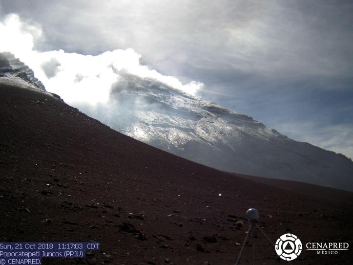
October 20, 2018, 1:06 p.m., Pacific:

October 20, 11:00 h (October 19, 16:00 GMT)
In the last 24 hours, through the monitoring systems of the Popocatépetl volcano, 41 exhalations, accompanied by steam and gas. Additionally, was recorded five volcanotectonic earthquakes, the first were ocurred yesterday at 11:54, 12:45, 16:18 and 19:15 pm with magnituds of 2.4, 2.0, 2.4 and 1.7, the last one was ocurred this morning at 05:45 am with magnitud of 2.4.
In most of the time we cannot see the volcano due to cloudy conditions, however, the few lapses in the clear sky can be observed the constant emission of water vapor and other gases (image 1).
At the time of this report, continues the intense cloudiness in the area of the volcano,however any important change in the activity will be notified in a timely manner.
CENAPRED emphasizes that people SHOULD NOT go near the volcano, especially near the crater, due to the hazard caused by ballistic fragments . . . and in case of heavy rains leave the bottoms of ravines by the danger of landslides and debris flows.
The Volcanic Traffic Light Yellow Phase 2.
Washington VAAC has not issued an advisory on Popocatepetl since early on the 17th.
October 18, 2018, 6:58 p.m., Pacific: The volcano was apparently at baseline over the last 24 hours or so–VAAC hasn’t issued an advisory since yesterday morning; however, the summit is hidden in clouds most of the time. I wouldn’t have added anything today, except that this tweet shows a cloud that mystifies me: it appears to be a species of lenticular cloud that I haven’t seen before!
Ult 24 h:
•36 exhalaciones.
•0 explosiones.
•1 sismo VT (Mc 2.0).
•0 min de tremor.«🚦Amarillo 2» pic.twitter.com/go5eQfvDJI
— Volcán Popocatépetl (@Popocatepetl_MX) October 18, 2018
https://platform.twitter.com/widgets.js
Quite a nice hat for Don Goyo!
October 17, 2018, 10:15 a.m., Pacific: All is at baseline, apparently, except for increased VT seismicity. Will just include a summary tweet from Puebla and this morning’s CENAPRED graphics.
El volcán #Popocatépetl presentó en las últimas 24 h:
◾114 exhalaciones de vapor de agua y gases.
◾7 minutos de tremor.
◾1 sismo VT, M= 2.0, ayer a las 15:24 h.
[Fuente: #CENAPRED]. pic.twitter.com/UEEooHZNJT— PC Estatal Puebla (@PC_Estatal) October 17, 2018
https://platform.twitter.com/widgets.js
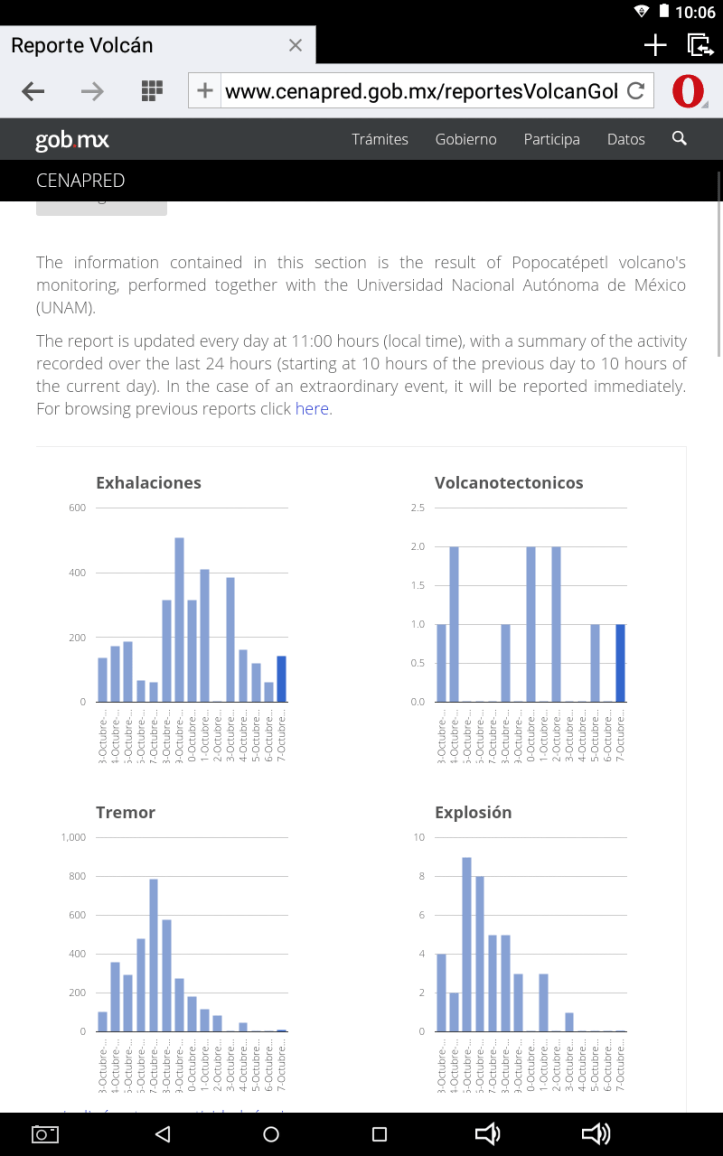
Washington VAAC issued an advisory yesterday afternoon, and from the graphic it looked to be a fairly big cloud, but it quickly dispersed. I’ve seen no online news reports or tweets about ashfall from that; the area is experiencing lots of rain, which may explain it. Weather makes it very difficult to see the summit these days, and apparently that is true for satellites, too, but this morning VAAC only noted one possible emission around 0400 UTC and that has dispersed.
October 16, 2018, 11:12 a.m., Pacific: A summary of today’s bulletin. Note that LPs are showing up again, per this tweet. “It’s imporant to respect the security radius of 12 km.”
En las últimas 24 horas el #Popocatépetl presentó algunos eventos LP (asociados al movimiento de fluidos) el más importante a las 3:12 am. Es importante respetar el radio de seguridad de 12 km. pic.twitter.com/jqazuYEJ21
— Oscar Zepeda (@capacapa) October 16, 2018
https://platform.twitter.com/widgets.js
However, Popo appeared at baseline (and quite impressive) from Puebla this morning:
El @Popocatepetl_MX y las torres de la Catedral de Puebla esta mañana… pic.twitter.com/rvLdq1AW76
— constanza lameiras (@constanza) October 16, 2018
https://platform.twitter.com/widgets.js
The volcano is steaming more than it has done over the few years that I’ve been watching the webcams (of note, at the moment Popo is playing peekaboo with the clouds).
Update, October 16, 2018, 2:14 p.m. Pacific: Per this story (Spanish), the steaming is due to increased environmental humidity and colder air temperatures at this time of year, which makes sense. However, they report an investigator at the University Center for the Prevention of Regional Disasters noting that Popo’s activity has significantly increased, with up to 500 exhalations and 4-5 explosions per day over the last four weeks. CENAPRED’s Scientific Advisory Committee kept the Yellow Phase 2 alert level at the last meeting, but they are watching it carefully.
Also, Dr. Valdes uses a sand clock to show how the LP quakes are generated inside the volcano:
Un reloj de arena nos permite entender cómo se generan los sismos “lp” en un volcán. Aquí el material ejerce presión para pasar por un cuello o conducto estrecho, generando señales de vibración. En un volcán estas señales implican ascenso de fluidos que contien magma, gas y agua. pic.twitter.com/EKW34aT3pa
— Dr. Carlos Valdes (@CarlosMValdes1) October 16, 2018
https://platform.twitter.com/widgets.js
Per Google Translate: “An hourglass allows us to understand how “lp” earthquakes are generated in a volcano. Here the material exerts pressure to pass through a narrow neck or conduit, generating vibration signals. In a volcano, these signals imply the rise of fluids that contain magma, gas and water.”
October 15, 2018, 12:33 p.m.: A dawn image, taken from Mexico City:
El Popocatépetl cubriendo con su manto Iztaccíhuatl. pic.twitter.com/KuqRhHwGmn
— Dr. Carlos Valdes (@CarlosMValdes1) October 15, 2018
https://platform.twitter.com/widgets.js
“Popocatépetl covering Iztaccíhuatl [another, much sleepier volcano just to the north, or left in the image] with his cloak.” This refers to the old legends.
October 15, 11:00 h (October 15, 16:00 GMT)
In the last 24 hours, through the monitoring systems of the Popocatépetl volcano, 121 exhalations were identified. During most of the time covered by this report there has been no visibility towards the volcano. However, from 06:00 pm, an intermittent plume of gases and water vapor directed to the northwest could be observed (image 1). In addition, at 23:43 a volcanotectonic event with magnitude 1.4 is recorded.
During the night there was partial visibility of the crater volcano. Incandescence was not observed but the emission of steam and gases the period of most intensity lasted approximately between 06:50 and 09:50 am, the height of the plume was less than 1 km and dispersed in a northwest direction (Video 1).
At the time of this report, There is no visibility to the volcano due to the intense cloudiness in the area.
CENAPRED emphasizes that people SHOULD NOT go near the volcano, especially near the crater, due to the hazard caused by ballistic fragments . . . and in case of heavy rains leave the bottoms of ravines by the danger of landslides and debris flows.
The Volcanic Traffic Light Yellow Phase 2.
Was able to get into the graphics this morning–they are reassuring.

However, I was reading in the Pozzo et al. paper yesterday (see above) that Popo is considered a “low deformation” volcanic system, and that VT quakes are sometimes eruption precursors, too. Overall, though, the volcano seems at its baseline.
Everyone is maintaining their watch, though:
El Presidente Auxiliar de Santiago Xalitzintla, en San Nicolás de los Ranchos, #Puebla, comenta que están organizados para evacuar debido a la actividad del volcán #Popocatépetl en un caso necesario: pic.twitter.com/UwrmESXI3A
— PC Estatal Puebla (@PC_Estatal) October 15, 2018
https://platform.twitter.com/widgets.js
Sorry, I’m not good with spoken Spanish. This is an official of Santiago Xalitzintla, saying, per this tweet by Puebla State, that they are making evacuation plans in a volcano emergency.
And here is the current image from Tlamacas webcam; not sure what those white streaky things are, but given the huge steam plume chuffing from the volcano’s crater, am guessing it’s ice/snow scrubbed clean of ash and at an angle that catches sunlight:
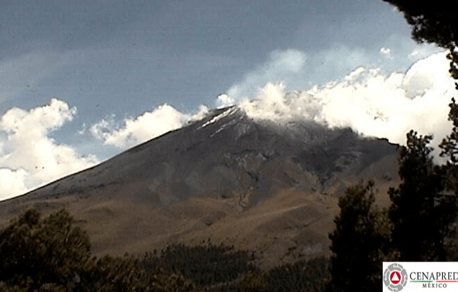
October 14, 2018, 11:26 a.m. Pacific:
El volcán #Popocatépetl en las últimas 24 h presentó:
⭐ 161 exhalaciones de vapor de agua y gases.
⭐ 48 minutos de tremor de baja amplitud.
[Fuente: #CENAPRED]. pic.twitter.com/QChyaZWuP6— PC Estatal Puebla (@PC_Estatal) October 14, 2018
https://platform.twitter.com/widgets.js
Clouds are obscuring the volcano in the webcams at the time of writing, but it does occasionally show itself.
Today’s update, per Google Translate (except for the traffic signal located in Amarillo [see my note farther down in this past week’s updates]):
In the last 24 hours, through the Popocatepetl volcano monitoring systems, 161 exhalations were identified, as well as 48 minutes of low amplitude tremor. For most of the time covered by this report there was no visibility to the volcano, but when it could be seen an intermittent plume of gases and water vapor was observed to the northwest.
During the night there was partial visibility of the volcano crater. No incandescence was observed but the emission of gases was observed.
From this morning until the moment of this report, partial visibility has been obtained, and the intermittent emission of water vapor and gases continues.
The CENAPRED urges NOT TO APPROACH the volcano and especially the crater, for the danger that involves the fall of ballistic fragments and in case of heavy rains away from the bottoms of ravines by the danger of landslides and mudflows.
The Popocatepetl Volcanic Alert Traffic Light remains at Yellow Phase 2.
October 13, 2018, 9:25 a.m., Pacific: Still waiting for this morning’s update. On cams, the volcano is socked in, but apparently Don Goyo felt kindly toward webcams in the general direction of Xalitzintla (where some tiemperos live):
El volcán #Popocatépetl esta mañana emite vapor de agua y gases… Visto desde Santiago Xalitzintla, San Nicolás de los Ranchos, #Puebla. pic.twitter.com/qHUl9Tl8mz
— PC Estatal Puebla (@PC_Estatal) October 13, 2018
https://platform.twitter.com/widgets.js
Washington VAAC reports a very light ash emission about two hours ago.
10:24 a.m., Pacific: Here it is, via Google Translate. No mention of tremor or seismicity. Wish I could check the deformation/seismicity graphics.
In the last 24 hours, through the monitoring systems of the Popocatépetl volcano, 384 exhalations were identified, accompanied by water vapor, gas and ash. Additionally an explosion was recorded yesterday at 11:40 h.
During the night there was partial visibility of the crater of the volcano and incandescence could be observed. At the time of this report there is no visibility, any event will be dispersed in a westerly direction.
The CENAPRED urges NOT TO APPROACH the volcano and especially the crater, for the danger that involves the fall of ballistic fragments and in case of heavy rains away from the bottoms of ravines by the danger of landslides and mudflows.
October 12, 2018, 12:05 p.m., Pacific: The volcano is still in Yellow, Phase 2, but some of the news in the update is concerning (emphasis added), as is the tweet below today’s quote below. That tweet shows serial events continuing for a little while this morning (a couple of hours ago at the time of writing).
In the last 24 hours, through the monitoring systems of the Popocatépetl volcano, 452 exhalations were identified, accompanied by water vapor, gas and ash. Also recorded were 30 minutes of LP train and tremor, recorded from 03:36 to 04:07 today. There were also 82 minutes of tremor of medium and low amplitude. Additionally, two volcanotectonic earthquakes were recorded, recorded yesterday at 4:34 pm and 8:28 pm, with magnitudes of 1.0 and 2.4, respectively.
During the night there was no visibility, in the morning you could see the crater of the volcano. At the time of this report there is no visibility, any event will be dispersed in a westerly direction.
The CENAPRED urges NOT TO APPROACH the volcano and especially the crater, for the danger that involves the fall of ballistic fragments and in case of heavy rains away from the bottoms of ravines by the danger of landslides and mudflows.
LP means “long-period” and these quakes are produced as moving magma breaks rocks, per Michigan Tech. This is an eruption precursor, per seismologists in the Pacific Northwest, but in 1980 Mount St. Helens had LP quakes for months before it went off.
A partir de las 11:23 h, el volcán #Popocatépetl ha presentado una serie de eventos, a las 11:40 se registra una explosión con altura aproximada de 2 km. pic.twitter.com/JwhtKCbT7R
— Oscar Zepeda (@capacapa) October 12, 2018
https://platform.twitter.com/widgets.js
VAAC’s current advisory mentions another emission within the past hour and a dispersing cloud of ash extending about 30 nautical miles from the summit. Of course, they don’t get into seismological information.
Once again, I can’t get into the update site to see the deformation and seismicity graphics. And the webcam shows mostly clouds. Sigh.
October 11, 2018: No training exhalations mentioned in this morning’s update, but VAAC did issue multiple advisories on Popo yesterday. Mostly it was cloud-covered, but CENAPRED did get this (from yesterday):
https://youtu.be/Wtm8AuVkb44&rel=0
Again, I can’t get into the report website this morning, so here’s a Google Translate version:
In the last 24 hours, through the monitoring systems of the Popocatépetl volcano, 411 exhalations were identified, accompanied by water vapor, gas and ash. There were also 3 explosions yesterday at 10:39, 15:21 and 15:33. Additionally, 118 minutes of tremor were recorded. During the night partial visibility was observed and slight incandescence was also observed. At the time of this report there is partial visibility, any event will be dispersed in the northeast direction.
The Popocatepetl Volcanic Alert Traffic Light is located in Amarillo Phase 2.
I just love the way GT interprets that last line. The machine detects “traffic signal” and the name of a Texas town, and therefore adds interprets “se encuentra” the word as “located”–it’s not in the original it is used as “remains at”; and “amarillo” is Spanish for “yellow.” See the “Challenges…” link at the top of this page for reasons why Mexico went with a traffic-signal volcano alert system.
Here is the volcano during a moment of atmospheric clarity this morning.
El volcán #Popocatépetl emite esta mañana vapor de agua y gases.
[Cámara Tlamacas del #CENAPRED]. pic.twitter.com/mcK6TGZm1M— PC Estatal Puebla (@PC_Estatal) October 11, 2018
https://platform.twitter.com/widgets.js
The State of Puebla has a very active Twitter feed, which is excellent for getting news. Surely other states near the volcano are conducting the same organization meetings that Puebla mentions holding this morning, where officials are planning shelters, evacuations, search and rescue operations, and so forth.
Reunión de trabajo de dependencias de gobierno con #ProtecciónCivilEstatal.
Tema: Evacuación, búsqueda y rescate en caso de contingencias ocasionadas por actividad del volcán #Popocatépetl. pic.twitter.com/E2xTqmXG9J— PC Estatal Puebla (@PC_Estatal) October 11, 2018
https://platform.twitter.com/widgets.js
If Don Goyo is strolling across the flanks of Popocatepetl this morning, he would surely approve!
VAAC’s latest advisory is from several hours ago and just mentions a “discrete puff” back then. (We all must adapt our words to Popocatepetl’s rather unique eruption style!)
Here is a news story (Spanish) about measures in the state of Tlaxcala.
October 10, 2018, 10:56 a.m., Pacific: Fewer exhalations than described in yesterday’s report, but for the first time a train of exhalations, which is concerning. Per Google Translate, since I can’t get into the update site just now:
In the last 24 hours, through the monitoring systems of the Popocatépetl volcano, 315 exhalations were identified, accompanied by water vapor, gas and ash. Two volcanotectonic earthquakes were also recorded, one yesterday at 2:33 pm and today at 07:33, with magnitude 1.2 and 1.7, respectively. Additionally, 182 minutes of tremor and 11 minutes of exhalation train recorded today from 01:20 to 01:31 h. During the night there was partial visibility and incandescence was also observed. At the time of this report there is partial visibility, any event will be dispersed in the northeast direction.
The Popocatepetl Volcanic Alert Traffic Light is located in Amarillo Phase 2.
The volcano’s summit is socked in by weather; via other sources, VAAC just reported another light ash emission.
Going by time, this was the start of the exhalation train during the wee hours, from Webcams de Mexico:
Durante la madrugada, a la 1:20 h. pic.twitter.com/T85yVt0MRg
— Volcán Popocatépetl (@Popocatepetl_MX) October 10, 2018
https://platform.twitter.com/widgets.js
October 9, 2018, 1:02 p.m., Pacific: Over 500 exhalations in the last 24 hours, per CENAPRED! This is way higher activity than any I’ve noticed over the last several years that I’ve been casually watching Popocatepetl on the webcams. However, today’s graphic shows decreased tremor, and while the seismic activity is still high, it’s still slightly less than the average from 1996-1998; also, no change in deformation. There reportedly is more magma, but the open conduit is handling it and the volcano isn’t pressurizing a lot, it looks like (but remember, I’m a layperson 🙂 ).
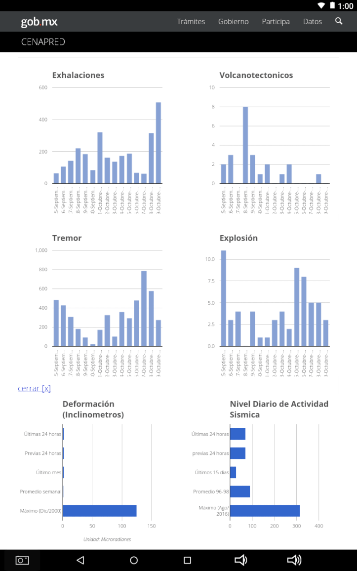
October 09, 11:15 h (October 09, 16:15 GMT)
In the last 24 hours, through the Popocatepetl volcano monitoring system was recorded, 509 low intensity exhalations, accompanied by steam, gas and ash (imagen 1) . Additionally were recorded three explosions yesterday at 17:20 (imagen 2) (video 1) , 17:34 and 18:34 h (imagen 3) (video 2) . Also was recorded 274 minutes of tremor. During the night, it was possible to observe the crater, but incandescence was not observed. At the moment of this report is possible observe the crater but any exhalation was dispersed to the north-est direction (imagen 4) .
CENAPRED emphasizes that people SHOULD NOT go near the volcano, especially near the crater, due to the hazard caused by ballistic fragments. . . and in case of heavy rains leave the bottoms of ravines by the danger of landslides and debris flows.
The Volcanic Traffic Light Yellow Phase 2.
Potentially good news is that Washington VAAC hasn’t put up an advisory on Popo since 1022 UTC, roughly ten hours ago.
October 8, 2018, 4:53 p.m., Pacific:
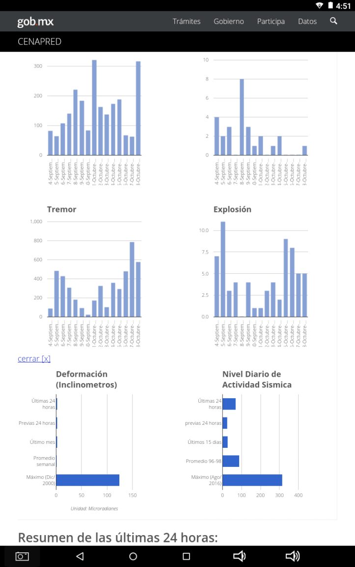
October 08, 11:00 h (October 08, 16:15 GMT)
In the last 24 hours, through the Popocatepetl volcano monitoring system was recorded, 316 low intensity exhalations, accompanied by steam, gas and ash (imagen 1), (imagen 2) . Additionally were recorded five explosions, three yesterday at 11:19, 15:21 and 16:51 h, and two today at 05:27 and 07:02 h (imagen 3), also was recorded 580 minutes of tremor. During the night, it was possible to observe the crater, but incandescence was not observed. At the moment of this report not possible observe the crater but any exhalation was dispersed to the north-est direction (imagen 4) .
CENAPRED emphasizes that people SHOULD NOT go near the volcano, especially near the crater, due to the hazard caused by ballistic fragments (image 4) and in case of heavy rains leave the bottoms of ravines by the danger of landslides and debris flows.
The Volcanic Traffic Light Yellow Phase 2.
Then, a little after 5 p.m. local time:
Detrás de las nubes la explosión de las 17:20 h.
Probablemente superó 3 km sobre el cráter. pic.twitter.com/aNRqQih6Tf— Volcán Popocatépetl (@Popocatepetl_MX) October 8, 2018
https://platform.twitter.com/widgets.js
Washington VAAC advises the cloud extends 20 nautical miles northeast of Popo, but is expected to dissipate quickly. The alert level is still yellow, phase 2:
Explosión del #Popocatépetl a las 17:20 horas, altura aproximada de 3 km. El semáforo volcánico se encuentra en #Amarillofase2 pic.twitter.com/Jc1RvJSsTR
— Oscar Zepeda (@capacapa) October 8, 2018
https://platform.twitter.com/widgets.js
October 7, 2018, 9:45 a.m., Pacific: Found this handy visual summary of the daily update. Sr. Zepeda is CENAPRED’s director of analysis and risk management. And look at that–784 minutes of tremor! It was low amplitude, though, per the text update, and a look at the information on CENAPRED’s website graphics (below the tweet) shows no increase in deformation or seismicity. Weather conditions make it impossible to see the volcano in the webcams, but Washington VAAC reported continuous emissions (i.e., the usual stuff lately) this morning.
Resumen de las últimas 24 horas de actividad en el volcán #Popocatépetl, continúa en #AmarilloFase2 pic.twitter.com/gyt3imhq9R
— Oscar Zepeda (@capacapa) October 7, 2018
https://platform.twitter.com/widgets.js

October 6, 2018, 9:17 Pacific: CENAPRED update today isn’t up yet. Here is an image of the volcano from Puebla just a few minutes ago, but VAAC hasn’t put up an advisory on it. The last one on Popocatepetl, as of the time of writing is 0931 UTC.
Así el volcán #Popocatépetl al momento… emitiendo vapor de agua, gases y cantidades ligeras de ceniza a una altura aproximada de 1,000 m sobre el nivel del cráter: pic.twitter.com/7Y5VQ019dm
— PC Estatal Puebla (@PC_Estatal) October 6, 2018
https://platform.twitter.com/widgets.js
Speaking of the VAAC center in Washington–the real center–have you seen this?
Eruption of #Popocatepetl yesterday, October 02: pic.twitter.com/2t3hbMYQle
— Washington VAAC (@WashVAAC) October 3, 2018
https://platform.twitter.com/widgets.js
I’m pretty sure it’s a fake account and a fauxtegraph. No blue check for one thing. Too, real US government accounts always have disclaimers on them. For another, there isn’t anything in any tweet that some troll couldn’t have picked up elsewhere on the Web–nothing really original. Finally, I’ve seen nothing on the VAAC website to indicate they even have a Twitter account–they don’t need followers, they need to get information to pilots in a timely way, and Twitter isn’t necessary for that.
So, both account and picture are probably fake. The closest we’re going to ever get to a conjunction of Popocatepetl and Aztec gods is my screen cap yesterday (see yesterday’s images). 🙂
Anyway, I read a news story yesterday saying that an Aztec god of death wasn’t emerging from Popocatepetl and thought it was satire. But apparently it was based on this fake image. Some people buy it.
That’s too bad, but fortunately people watching the volcano as it really is recognize its true beauty. Here is a view from October 2nd, as the colossus interacts with the atmosphere.
Awesome time lapse of the Popocatépetl Volcano spewing with a lenticular cloud dancing on it.
Via @webcamsdemexico. pic.twitter.com/1gfuMyQESQ
— Dakota Smith (@weatherdak) October 2, 2018
https://platform.twitter.com/widgets.js
And on an even more healthy psychological note, the local people are handling the stress in their traditional way. A “tiempero” has made the news (Spanish).
I mentioned this tradition in a previous post (where I misspelled the Spanish word).
These “timekeepers” are local people who have met the personification of Popocatepetl, often as children while out on the volcano’s flanks. That’s Don Goyo; I think it’s a reference to the man’s curly hair (as well as a Catholic saint); these curls resemble the steam clouds that often surround the top of the volcano.
Don Goyo appears to reassure people in times of trouble and warn them of danger.
It helps, as this video from Clio TV shows: I asked them, and there is no English-language transcript, but images speak a thousand words, and you can watch the tiempero in action when Popo suddenly awoke in 1994 and scared everybody, from the countryside up into the university and government levels. (And perhaps you have a computer ability to translate the captions–I don’t on my mobile device.)
The translation of the title is “Popocatepetl: The Volcano That Listens.”
https://youtu.be/1oBi3MoAGeU&rel=0
9:54 a.m., Pacific: Ah, here we go:
October 06, 11:00 h (October 06, 16:00 GMT)
In the last 24 hours, through the Popocatepetl volcano monitoring system was recorded, 67 low intensity exhalations, accompanied by steam, gas and ash (image 1). Additionally were recorded eight explosions, five yesterday at 17:30, 22:29, 22:35, 22:37 and 22:57 h, and three today at 00:49, 02:46 y 07:58 h, also was recorded 480 minutes of harmonic tremor. During the night, it was possible to observe the crater, and we cannot observe incandescence. At moment of this report is possible to observe that the emissions of steam, gas and ashes are dispersed to the north-west direction (image 2).
CENAPRED emphasizes that people SHOULD NOT go near the volcano, especially near the crater, due to the hazard caused by ballistic fragments . . . and in case of heavy rains leave the bottoms of ravines by the danger of landslides and debris flows.
The Volcanic Traffic Light Yellow Phase 2.
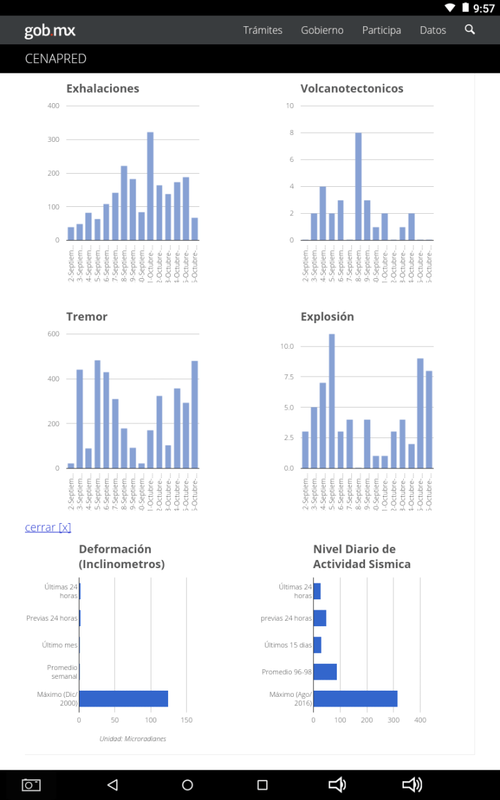
October 5, 2018: A look at where current activity is at in relationship to the past month, as well as a look at deformation (left–note how high it was in 2000!) and seismic activity (much higher in 2016):
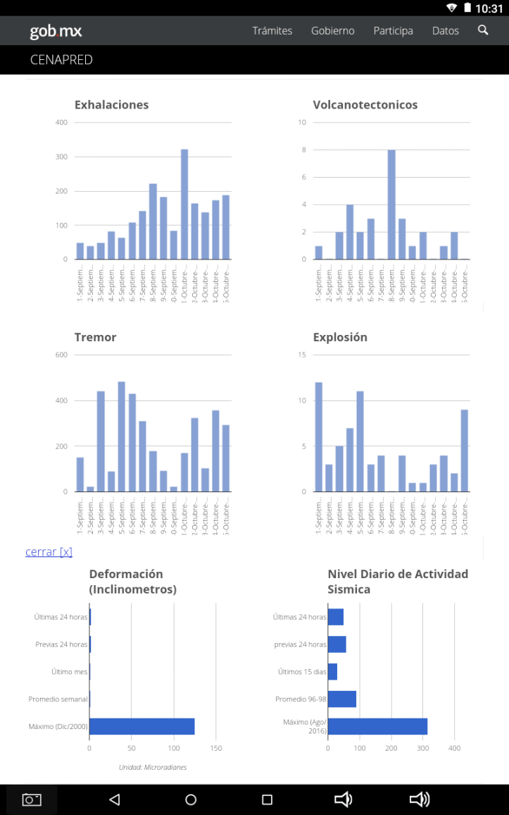
And here is the update for today; Popo has been having a lot of vulcanian explosions, but the alert level remains the same.
October 05, 11:00 h (October 05, 16:00 GMT)
In the last 24 hours, through the Popocatepetl volcano monitoring system was recorded, 188 low intensity exhalations, accompanied by steam, gas and ash (image 1). Additionally were recorded nine explosions, seven yesterday at 10:26, 13:53, 16:04, 16:28, 21:39, 23:02 and 23:04 h and two today at 01:28 and 09:36 (image 2) , also was recorded 358 minutes of harmonic tremor. During the night, it was possible to observe incandescence during some events, (image 3) .
At moment of this report is possible to observe that the emissions of steam, gas and ashes are dispersed to the west south-west direction (image 4).
CENAPRED emphasizes that people SHOULD NOT go near the volcano, especially near the crater, due to the hazard caused by ballistic fragments . . . and in case of heavy rains leave the bottoms of ravines by the danger of landslides and debris flows.
The Volcanic Traffic Light Yellow Phase 2.
Popo, about 15 minutes ago:
Leve explosión en el volcán #Popocatépetl a las 12:33 h. pic.twitter.com/QqyyOoTFoM
— PC Estatal Puebla (@PC_Estatal) October 5, 2018
https://platform.twitter.com/widgets.js
That ash, dispersing towards Mexico City and environs, plus the immense steam cloud that the colossus is huffing out right now, as seen from Puebla a few minutes ago:
Desde @Puebla pic.twitter.com/Xsv3n5MRjY
— Jaikel (@Jaikel01) October 5, 2018
https://platform.twitter.com/widgets.js
Still watching and waiting . . .
PS: Another explosion, soon after the one shown above in tweets . . . maybe Don Goyo is trying to shoot down that bug passing Aztec deity. :):

Update, October 5. 2018, 5:38 p.m.: No real changes, just checking the information. This happened about mid-afternoon:
Emisión de gases y ceniza del volcán #Popocatépetl, visto desde Paso de Cortés a través de #LiveCamPopocatépetl pic.twitter.com/MW3F8cWRp9
— PC Estatal Puebla (@PC_Estatal) October 5, 2018
https://platform.twitter.com/widgets.js
(Cortes Pass is indeed the pass Hernan Cortes used to cross the mountains and reach the Aztec capital centuries ago; not all historians are on board with the story that he sent a soldier (or one volunteered, depending on which source you’re using) to climb Popocatepetl and get sulfur to replenish the gunpowder supplies. And yes, Popo was doing much the same thing it’s doing now–vulcanian eruptions (though not the same one; the volcano had been quiet for a while before it erupted in 1994).
Anyway, that eruption shown in the tweet above has created an ash plume extending 9 nautical miles west of the summit, per Washington VAAC. An online news search doesn’t show any flight delays because of it, but Popo’s activity yesterday put enough ash into the air to affect flights at Mexico City and Toluca airports, per this story (Spanish).
Update, October 4, 2018, 5:59 p.m., Pacific: No change with Popo (another explosion since the last update); just wanted to share this. It is typical of tweets I’ve seen here and in other local and national jurisdiction, where officials get out and talk with people and local authorities, helping them get prepared for an increase in the eruption level.
Reunión de las autoridades de San Miguel Tecuanipa, #Tochimilco, con personal de la Dirección de Prevención de Desastres de #ProtecciónCivilEstatal para definir los puntos de concentración de personas en caso de ser necesaria una evacuación por actividad del volcán #Popocatépetl. pic.twitter.com/foezHnGPCr
— PC Estatal Puebla (@PC_Estatal) October 4, 2018
https://platform.twitter.com/widgets.js
Per Google Translate, “Meeting of the authorities of San Miguel Tecuanipa, with personnel of the Disaster Prevention Directorate of ProtecciónCivilEstatal to define the points of concentration of people in case of being necessary an evacuation by activity of the Popocatepetl volcano.”
As mentioned below, they are also arranging for shelters, setting up plans for school evacuations, repairing evacuation routes (this thing has been going on for 24 years and the climate can be very rainy), and so forth. Forewarned is indeed forearmed.
At this stage, you just don’t know how many lives these people might have saved today with this outreach.
Reunión de las autoridades de San Jerónimo Coyula, #Atlixco, con personal de la Dirección de Prevención de Desastres de #ProtecciónCivilEstatal para definir los puntos de concentración de personas en caso de una evacuación por actividad del volcán #Popocatépetl. pic.twitter.com/NWcpuv5aHF
— PC Estatal Puebla (@PC_Estatal) October 4, 2018
https://platform.twitter.com/widgets.js
Update, October 4, 2018, 1:10 p.m., Pacific: Whatever delayed it, the October 4th CENAPRED update is now up:
October 04, 11:00 h (October 04, 16:00 GMT)
In the last 24 hours, through the Popocatepetl volcano monitoring system was recorded, 173 low intensity exhalations, accompanied by steam, gas and ash (image 1). Additionally was recorded two explosions, one yesterday at 21:04 h, and one today at 08:46 h (image 2) , and two volcanotectonic events , one yesterday at 11:19 h and one today at 07:25 h with magnitudes 1.5 and 2.4 respectively. Also was recorded 358 minutes of harmonic tremor. The next video shows the activity from 06:42 and 09:55 h (video 1). During the night, it was not possible to observe the crater continuously, but was possible to observe some incandescence during some events, (image 3) .
At moment of this report is possible to observe that the emissions of steam, gas and ashes are dispersed to the west south-west direction (image 4).
CENAPRED emphasizes that people SHOULD NOT go near the volcano, especially near the crater, due to the hazard caused by ballistic fragments . . . and in case of heavy rains leave the bottoms of ravines by the danger of landslides and debris flows.
The Volcanic Traffic Light Yellow Phase 2
.
Here is a time-lapse video from SEGOB of this morning’s activity; interesting meteorological effects, both in the foothills and valleys as the sun heats the air and also above and downwind of the volcano, presumably from hot air parcels:
https://youtu.be/5iXdWGjHCKo&rel=0
Update, October 4, 2018, 10:32 a.m.: Uh-oh. Apparently there isn’t a unified front from the authorities. This story just came in. An excerpt, per Google Translate:
MEXICO CITY
The General Coordination of Civil Protection of the State of Mexico stressed that in the Popocatépetl volcano the activity prevails in the scenarios foreseen for the yellow alert Phase 2, in spite of the explosions that occurred on Thursday morning.
Through his Twitter account @pciviledomex, he asked the public to keep informed and observe the security measures especially if there is ash fall, as well as to be attentive to the volcanic warning light.
This morning saw another explosion, with a fumarole more than a kilometer high and with a high ash content, informed the National Coordinator of Civil Protection of the Ministry of the Interior (Segob), Luis Felipe Puente.
#Video de la actividad del #Popocatépetl registrada esta mañana a las 7:37 horas, vista desde Altzomoni. Vía #CENAPRED 🌋 pic.twitter.com/ecOYFH950A
— Luis Felipe Puente (@LUISFELIPE_P) October 4, 2018
https://platform.twitter.com/widgets.js
In his account @LUISFELIPE_P of Twitter, the federal official explained that before the possibility of ash fall, it is important that the population follow the recommendations of civil protection to avoid damages to health, although the traffic light of volcanic alert remains in Yellow Phase 2. . .
Here’s what I don’t understand–what happened to CENAPRED? What is Sr. Fuente’s scientific basis for his statements, and why is it apparently no longer public now?
Dr. Valdes changed his Twitter profile over the weekend from Director General of CENAPRED to seismology investigator at the University of Mexico. I didn’t mention it here because it had no apparent connection to the volcano. He did not mention Popo again until this morning, when he tweeted:
El Centro Nacional de Prevención de Desastres de SEGOB, vigila y evalúa constantemente la actividad del volcán Popocatépetl. pic.twitter.com/cr8DlIeQIQ
— Dr. Carlos Valdes (@CarlosMValdes1) October 4, 2018
https://platform.twitter.com/widgets.js
“The National Center for Prevention of Disasters . . . constantly monitors and evaluates the activity of Popocatepetl volcano.”
But starting today, the top stories on their website are about astronomical phenomena and flooding (which is happening in the area). There is no October 4th update from CENAPRED, even though it is in eruption as you can see in the cams (above) and other shared imags here.
Now, I’m sure everyone is trying to do what is best for the people of Mexico–the stakes are incredibly high here. There probably is a reasonable explanation for what has happened. But this must be shaking up a lot of people today in the affected area. Thankfully, I’ve never been in such a high-pressure situation, but everything I’ve read about communication during a volcanic crisis emphasizes the importance of scientists and authorities speaking with one voice.
There seems to have been a fracture here. And it comes at a very bad time.
I will simply ask this and leave it hanging: is it scientifically accurate to maintain Popocatepetl at Yellow Phase 2 this morning, same as the previous mornings in recent years? When does the alert level change, who decides it, and what measures for public safety will be enabled?
Also, what can we expect from the volcano in the coming days and weeks?
It’s not enough just to say, the alert color is the same and stay in your homes and protect yourselves. You have to give people some information to work with, especially at a time like this.
Update, October 4, 2018, 9:47 a.m., Pacific: No word yet from CENAPRED per its website, and I can’t get into the monitoring page, but here’s the current view from near Puebla:
El volcán #Popocatépetl al momento… desde Coyula: pic.twitter.com/QkG6f4cdpq
— PC Estatal Puebla (@PC_Estatal) October 4, 2018
https://platform.twitter.com/widgets.js
Explosión en el volcán #Popocatépetl a las 09:06 h, con columna eruptiva de más de 1,200 m de altitud sobre el nivel del cráter: pic.twitter.com/Z0eD8NcXKU
— PC Estatal Puebla (@PC_Estatal) October 3, 2018
https://platform.twitter.com/widgets.js
October 4, 2018: Several explosions at Popo this morning, just checking Twitter feeds while waiting for CENAPRED update (update: it’s late this morning). This is from a Webcams de Mexico Twitter account, Google translation below:
¿Qué hacer ante esta actividad?
•Respetar el radio de 12 km desde el cráter.
•Evitar rumores.
•Usar cubrebocas y barrer la ceniza.
•Evitar que la ceniza entre en tinacos/cisternas.
•NO dejar a mascotas y sus alimentos expuestos al aire libre.
•Estar informado. pic.twitter.com/AvAp4nbG8Q— Volcán Popocatépetl (@Popocatepetl_MX) October 4, 2018
https://platform.twitter.com/widgets.js
“What to do before this activity? Respect the radius of 12 km from the crater. Avoid rumors. Wear masks and sweep the ash. Prevent the ash from entering the water tanks/cisterns. DO NOT leave pets and their food exposed to the outdoors.”
Chemicals in ash can be harmful and will leach into food, water, grass, etc. In 1783, many Icelanders experienced famine because of this effect on their livestock (from the Laki eruption) as well as on their crops.
Per other tweets, there are reports of a “combustible odor” in Puebla, but that probably has nothing to do wtih the volcano’s emissions, as the wind is in the opposite direction, as shown on this map of predicted ashfall from one of this morning’s explosions:
Resultado del Modelo HYSPLIT indica que la ceniza, en caso de emisiones del volcán Popocatépetl en las próximas 24 horas, se dirigiría hacia:
🔹San Juan Amecac
🔹Acteopan
🔹 San Felipe Tepemaxalco
🔹Cohuecan
🔹Teolco
🔹Tepexco
🔹EdoMéx
🔹Morelos pic.twitter.com/IoMX06lz6c— PC Estatal Puebla (@PC_Estatal) October 4, 2018
https://platform.twitter.com/widgets.js
October 3, 2018: Still waiting and watching:
In the last 24 hours, through the Popocatepetl volcano monitoring systems, 163 exhalations were identified, accompanied by water vapor, gas and light amounts of ash. Three explosions, two recorded yesterday at 10:13 and 22:37 and one today at 04:26 with emission of water vapor, gas and moderate ash content. In addition, 324 minutes of harmonic tremor, of which 20 minutes recorded amplitude between 4 and 30 um, peak to peak, the others had amplitudes less than 4 um. During the night, the volcano could be observed with a constant emission of water vapor and gas as well as slight incandescence. At the time of this report, the continuous emission of water vapor and gas is observed, with a southwest west direction.
The CENAPRED urges NOT TO APPROACH the volcano and especially the crater, for the danger that involves the fall of ballistic fragments and in case of heavy rains away from the bottoms of ravines by the danger of landslides and mudflows.
The Popocatepetl Volcanic Alert Traffic Light is located in
AmarilloYellow Phase 2.
Addendum, October 3, 2018, 6:26 p.m. Pacific: Just came across this lovely view. Yes, that’s more activity than Popo has done lately. Still, it’s a piece of art. Unless you feel it yourself–and it has gotten me watching the volcano over the past several years on the CENAPRED webcams–it’s hard to describe the affection one develops for this beautiful, terrible place.
Comparto con @Popocatepetl_MX y @webcamsdemexico este #timelapse de la mañana de este domingo 30 de septiembre. Saludos. pic.twitter.com/1oIuH1AygA
— Rosendo Quintos (@Rosendo_Quintos) October 3, 2018
https://platform.twitter.com/widgets.js
October 2, 2018, 5:56 p.m., Pacific: No change in alert, but this tweet from Puebla officials shows how volcanologists can monitor a volcano even when they can’t see it very well (of note, the rainy season at Popocatepetl is almost over and webcam views will clear around the end of this month):
Explosión en el #Popocatépetl a las 14:51 h. La columna eruptiva de esta explosión rebasó los 3 km de altura.
Sin dirección referencial evidente de la dispersión de ceniza debido a la nubosidad en la zona; la dirección de los vientos indica hacia el oeste, o sea, al #EdoMéx. pic.twitter.com/ivhEPhZuOU— PC Estatal Puebla (@PC_Estatal) October 2, 2018
https://platform.twitter.com/widgets.js
“Explosion at Popocatepetl at 2:51 p.m. [local time]. The eruptive column from this explosion rose 3 km in height. Without direction reference of ash dispersion because of cloudiness, the wind direction indicates to the west, or to Mexico City [technically, the State of Mexico].”
October 2, 2018, 12:44 p.m.: Don Goyo is majestic, even when it is scary:
El volcán #Popocatépetl presentó en las últimas 24 h:
◽163 exhalaciones de vapor de agua, gases y ligeron contenido de ceniza.
◽3 explosiones.
◽324 minutos de tremor.
[Fuente: #CENAPRED]. pic.twitter.com/OijuyRk7UB— PC Estatal Puebla (@PC_Estatal) October 2, 2018
https://platform.twitter.com/widgets.js
In CENAPRED’s update this morning, they gave more detailed information about the harmonic tremor (emphasis added); first time I’ve seen them do that. However, the alert is still Yellow Phase 2.
In the last 24 hours, through the Popocatepetl volcano monitoring systems, 163 exhalations were identified, accompanied by water vapor, gas and light amounts of ash. Three explosions, two recorded yesterday at 10:13 and 22:37 and one today at 04:26 with emission of water vapor, gas and moderate ash content. In addition, 324 minutes of harmonic tremor, of which 20 minutes recorded amplitude between 4 and 30 um, peak to peak, the others had amplitudes less than 4 um. During the night, the volcano could be observed with a constant emission of water vapor and gas as well as slight incandescence. At the time of this report, the continuous emission of water vapor and gas is observed, with a southwest west direction.
The CENAPRED urges NOT TO APPROACH the volcano and especially the crater, for the danger that involves the fall of ballistic fragments and in case of heavy rains away from the bottoms of ravines by the danger of landslides and mudflows.
The Popocatepetl Volcanic Alert Traffic Light is located in Amarillo Phase 2.
October 1, 2018, 8:25 p.m., Pacific: Nothing new–I just keep checking the sources. Another low-level emission at the moment:
El volcán #Popocatépetl al momento… con emisiones que contienen ceniza y se dirigen al noroeste. pic.twitter.com/tmARNiJVgA
— PC Estatal Puebla (@PC_Estatal) October 2, 2018
https://platform.twitter.com/widgets.js
There is no change in alert status, either, but this official Puebla account does warn against believing in rumors, like one apparently circulating now that a sudden evacuation is about to be called. It’s false: still Yellow Phase 2 and no evacuations are imminent.
Yet.
Volcanoes are stressful, even when they don’t erupt violently.
Addendum, October 2nd: This article (Spanish) may explain the rumors: officials have 700 schools near the volcano set up to act as shelters if and when an evacuation is called. Actually, after running that through Google Translate, they’re planning to evacuate 700 schools, with about 20,000 students, near Popocatepetl, if necessary. “Thousands” of schools are to be used as shelters, but these are at some distance from the volcano.
Meanwhile, at the time of writing this, Popo simmers under the faint moonlight:
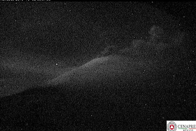
Yes, that is ash, and an advisory is in place:

October 1, 2018: A vulcanian eruption at 10:13 this morning, local time. This is not the big one (VAAC Washington called it small), but like many of these explosions, it’s bigger than what the volcano has been doing in recent years.
Emisión de ceniza a las 10:13 h: pic.twitter.com/lggdjhyQXS
— PC Estatal Puebla (@PC_Estatal) October 1, 2018
https://platform.twitter.com/widgets.js
You see that white glacier on the right? I suppose as the magma gets higher, the edifice will warm up and that glacier will melt, bringing lahars and floods into the lowlands. CENAPRED routinely warns people to stay out of ravines and canyons, because it’s risky even with rainfall.
Just another volcanic hazard at Popocatepetl. Sigh.
Another tweet shows that they are using HYSPLIT, the same model that volcanologists used to predict vog travel at Kilauea during this summer’s LERZ eruption (and probably they’re still using it there, of course):
🔎 Resultado del Modelo HYSPLIT indica que la ceniza, en caso de emisiones del volcán Popocatépetl en las próximas 24 horas, se dirigiría hacia:
◻ San Juan Amecac
◻ Acteopan
◻ Cohuecan
◻ Teolco
◻ Tepexco
◻ EdoMéx
◻ Morelos pic.twitter.com/aT1jf4T9DP— PC Estatal Puebla (@PC_Estatal) October 1, 2018
https://platform.twitter.com/widgets.js
Of note, Puebla is on the other side of the range (clear, in this image, which shows potential ashfall in Mexico City and nearby areas).
I wasn’t a volcanophile back in 1980 and so missed the media coverage of Mount St. Helens’s reactivation and eventual eruption. But truly this watchful waiting at Popocatepetl must be similar, though the US media is missing it because it’s happening in another country. This is even worse, because so much infrastructure and so many people are at risk.
Things seem a little quieter as described by CENAPRED this morning, but that’s no longer comforting in terms of a possible long-term trend, in light of this weekend’s announcement from UNAM experts. But the alert level is still the same.
Per Google Translate:
September 30, 11:15 h (September 30, 16:15 GMT)
In the last 24 hours, through the monitoring systems of the Popocatépetl volcano, 84 exhalations were identified, accompanied by water vapor, gas and light quantities of ash. An explosion at 07: 01h with emission of water vapor, gas and moderate ash content of 2400m in height. A volcanotectonic earthquake was also recorded yesterday at 6:59 p.m. with magnitude 1.5. In addition, 23 minutes of harmonic tremor of low amplitude. During the night, the volcano was observed with a constant emission of water vapor and gas 800m high. At the time of this report, the continuous emission of water vapor and gas is observed, with a west direction.
The Popocatepetl Volcanic Alert Traffic Light is located in
AmarilloYellow Phase 2.
Amarillo, besides being a town in Texas, means “yellow.”
September 30, 2018: An impressive explosion this morning, a little after 7:
#Video de la Emisión de las 07:10 horas del #Volcán #Popocatépetl pic.twitter.com/1sZ6aOZHGy
— Luis Felipe Puente (@LUISFELIPE_P) September 30, 2018
https://platform.twitter.com/widgets.js
Yep, Don Goyo is packing more muscle these days.
And, per Dr. Valdes, here’s an image of a light explosion at Popo this morning at 10:06 local time. They’ve installed new seismic stations, GPS, and surveillance cameras, thanks to the Preventive Fund working together with CENAPRED and the University of Mexico’s Geophysics Institute.
Explosión leve en el volcán Popocatépetl 10:06. Se han instalado en el Volcán nuevos equipos sísmicos de pozo, GPS y cámaras de vigilancia, con un proyecto del Fondo Preventivo (Fopreden), que han llevado en conjunto CENAPRED y el Instituto de Geofísica de la UNAM. pic.twitter.com/XltTEjAnST
— Dr. Carlos Valdes (@CarlosMValdes1) September 30, 2018
https://platform.twitter.com/widgets.js
I’m impressed at how seriously the volcanologists are taking this and also at the news coverage, which is calm, measured, and informative. I think here in the States there would be a media circus if scientists said a large amount of magma was rising in a volcano; but then, 25 million people being at risk when it erupts is a very sobering consideration.
Be safe, people!
Here is today’s CENAPRED update:
September 29, 11:00 h (September 29, 16:00 GMT)
In the last 24 hours, through the Popocatepetl volcano monitoring system, 183 low intensity exhalations, accompanied by steam, gas and small amounts of ash (image 1), (image 2) , as well as light incandescence (image 3) . An explosion was registered at 02:10 h (image 4), (image 5), (video 1). Additionally, 92 minutes of low amplitude-harmonic tremor. Also, three volcanotectonic earthquakes were registered yesterday at 11:07 h, 18:41 h and 19:44 h with magnitudes 2.5, 1.7 and 2.6, respectively.
CENACOM confirms ash falling in comunities to the west of the Popocatépetl: Atlautla, Tehuixtitlan, Cuecuecuautitla, Estado de México.
At the moment of this report we can see the volcano the continuous emission of volcanic gases in a westerly direction (image 6) , (image 7).
CENAPRED emphasizes that people SHOULD NOT go near the volcano, especially near the crater, due to the hazard caused by ballistic fragments . . . and in case of heavy rains leave the bottoms of ravines by the danger of landslides and debris flows.
The Volcanic Traffic Light Yellow Phase 2.
Popocatépetl. 11:10, altura 1.2 km de altura, dirección noroeste. Semáforo Amarillo Fase 2. pic.twitter.com/DjCw71lDHV
— Dr. Carlos Valdes (@CarlosMValdes1) September 29, 2018
https://platform.twitter.com/widgets.js
September 29, 2018: More of the same, including light ashfall, with a little bit less tremor, but a few small earthquakes that caused local headlines.
Light ashfall in parts of Mexico City this morning:
Tenemos reporte de caída de ceniza en forma ligera en las Delegaciones TLH, MLP, IZP , XOCH, IZC, COY, TLAP, MC y BJ, pendientes @SPCCDMX pic.twitter.com/K6Swfjp7Cq
— Fausto Lugo (@FaustoLugo) September 29, 2018
https://platform.twitter.com/widgets.js
September 29, 11:00 h (September 29, 16:00 GMT)
In the last 24 hours, through the Popocatepetl volcano monitoring system, 183 low intensity exhalations, accompanied by steam, gas and small amounts of ash (image 1), (image 2) , as well as light incandescence (image 3) . An explosion was registered at 02:10 h (image 4), (image 5), (video 1). Additionally, 92 minutes of low amplitude-harmonic tremor. Also, three volcanotectonic earthquakes were registered yesterday at 11:07 h, 18:41 h and 19:44 h with magnitudes 2.5, 1.7 and 2.6, respectively.
CENACOM confirms ash falling in comunities to the west of the Popocatépetl: Atlautla, Tehuixtitlan, Cuecuecuautitla, Estado de México.
At the moment of this report we can see the volcano the continuous emission of volcanic gases in a westerly direction (image 6) , (image 7).
CENAPRED emphasizes that people SHOULD NOT go near the volcano, especially near the crater, due to the hazard caused by ballistic fragments. . . and in case of heavy rains leave the bottoms of ravines by the danger of landslides and debris flows.
The Volcanic Traffic Light Yellow Phase 2.
Here’s an earlier eruption this morning, seen from Puebla, I think, on the other side of the range:
Explosión en el volcán #Popocatépetl a las 08:05 h: pic.twitter.com/uhhAeI4qns
— PC Estatal Puebla (@PC_Estatal) September 29, 2018
https://platform.twitter.com/widgets.js
Remember, Don Goyo has been doing this almost continously since 1994. What a strain on local communities, authorities, and emergency management officials! Why? Because it’s impossible to predict whether the next outburst might be much bigger; it’s possible, based on the volcano’s history.
My concern, just as a lay onlooker, is that there does seem to be a slight uptick in the overall activity recently (per previous notes below); that’s why I’ve started live-blogging it.
Update, 1 p.m. Pacific: Just read this article (Spanish), and learned that volcanologists suspect the increased activity may be due to that large quake in the area last year. They will be placing four more monitoring stations around Popo in coming weeks.
Excerpts, per Google Translate:
The activity of the Popocatépetl volcano is increasing and one of the causes would be linked to the magnitude 7.1 earthquake, which occurred on September 19, 2017, with an epicenter on the state boundary between the Puebla and Morelos states, said Ana Lillian Martín del Pozzo, volcanologist at the Institute of Geophysics (IGf) of the UNAM
…the specialist said that the colossus has not stopped, “he has been awake since December 1994, he has not gone to sleep, but the earthquake of 19 September of last year, whose epicenter was in a relatively close area, affected it. ”
“Its dynamism has been registered for a month, showed a high point on Thursday September 20, and yesterday saw another important issue column,” he said in a statement issued by the National Autonomous University of Mexico (UNAM).
The volcanologist said that last Sunday a group of geologists collected samples of ash to analyze and identified magma droplets, which possibly “are associated with domes that appear to be smaller, are formed when the magma rises and are sprayed, and have been presented in chain.
One is created and explodes, then another, and explodes, but we must be careful and careful to know if there are changes. “This is a different volcanic activity than what has been presented in other periods,” he said.
…
On the “Effects of the September earthquakes on the Popocatépetl”, Ramón Espinasa Pereña, deputy director of Volcanic Risks of the Research Directorate of the National Center for Disaster Prevention (Cenapred), … explained that in 2015 the colossus had an average of 16.5 monthly vulcano-tectonic earthquakes; in 2016 that number increased to 35; in 2017, before September, the average was 39, “but it was already increasing”.
From that month until December last year, it rose to 110, and in January 2018 “the record was broken with 221, and although it has decreased since February, we are still above base levels, with 87,” he explained.
He said that the day after the earthquake on September 19, the Popocatépetl had the maximum of exhalations that have been had in a single day, with 286, although that number began to increase much earlier.
“The good news is that it is feasible to predict a major eruption from monitoring data with a well-functioning network thanks to a project with the Geophysics Institute, station relay and well seismograph placement, instead of seismographs. surface, “he said.
In that sense, he pointed out that six stations currently operate in the cone of the volcano and in the next few weeks another four will be placed, below…
I just read the UNAM bulletin (Spanish), released online about three hours ago, and am going to do a post on it.
September 28, 2018: No major changes in this morning’s update; tremor is down a bit. Per Dr. Valdes, director general of CENAPRED, “Exposion at Popocatepetl volcano, 10:27. A clear difference between water vapor and ash. Alert yellow, phase 2. Safety radius [no-go zone] 12 km.”
Explosión en el volcán Popocatépetl. 10 :27. Clara diferencia entre vapor de agua y ceniza. Semáforo Amarillo Fase 2. Radio de seguridad 12 km. pic.twitter.com/UfyTRv17nA
— Dr. Carlos Valdes (@CarlosMValdes1) September 28, 2018
https://platform.twitter.com/widgets.js
September 27, 2018: Put yourself in the volcanologist’s place. This goes on day after day, decade after decade, in a volcano with a much more violent history, and there are some 25 million people at risk.
And through it all, constantly on alert, these heroes maintain their watch and issue their daily reports.
In the last 24 hours, through the monitoring systems of the Popocatépetl volcano, 141 exhalations were identified, accompanied by water vapor, gas and light amounts of ash. Likewise, there were 4 explosions at 22:59, 23:59, 00:48 and 02:44 h. In addition 309 minutes of harmonic tremor of low amplitude. At the time of this report, the continuous emission of volcanic gases is observed, which winds disperse to the west.
CENAPRED urges NOT TO APPROACH the volcano and especially the crater, for the danger of falling ballistic fragments and in case of heavy rains away from the bottoms of ravines because of the risk of landslides and mudflows.
September 26, 2018: Popo hasn’t settled down, but it’s not increasing its activity, either. Yellow Phase 2, still, and no more updates tweeted by Dr. Valdes thus far. Per Google Translate today:
In the last 24 hours, through the monitoring systems of the Popocatépetl volcano, 107 exhalations were identified, accompanied by water vapor, gas and light amounts of ash, the most important were those recorded yesterday at 4:12 pm and 17 : 03 h. Likewise, there were 3 explosions, 430 minutes of low amplitude harmonic tremor and three volcanotectonic earthquakes, with magnitude between 1.4 and 1.8. During the night, slight incandescence was observed over the crater. At the time of this report there is no visibility to the volcano, however early in the morning the continuous emission of volcanic gases, which the winds disperse to the west, was observed.
One good thing to come of all this excitement–local authorities are reviewing the condition of evacuation routes (Spanish), in case they are eventually needed.
September 25, 2018: From Dr. Valdes, early this morning (that’s not flowing lava but incandescent fragments):
Explosión de las 3:18 en el volcán Popocatépetl. Fragmentos hasta 1 km. pic.twitter.com/NrMbaCivm9
— Dr. Carlos Valdes (@CarlosMValdes1) September 25, 2018
https://platform.twitter.com/widgets.js
And this morning’s daily update (CENAPRED didn’t issue special reports–vulcanian activity like this is what Popocatepetl does now and then; the concern is that it isn’t known whether this can escalate into a bigger event–Popo has some Plinian eruptions and flank collapses in its past [those links are to general info; see background post links above for more details of Popocatepetl’s own history]):
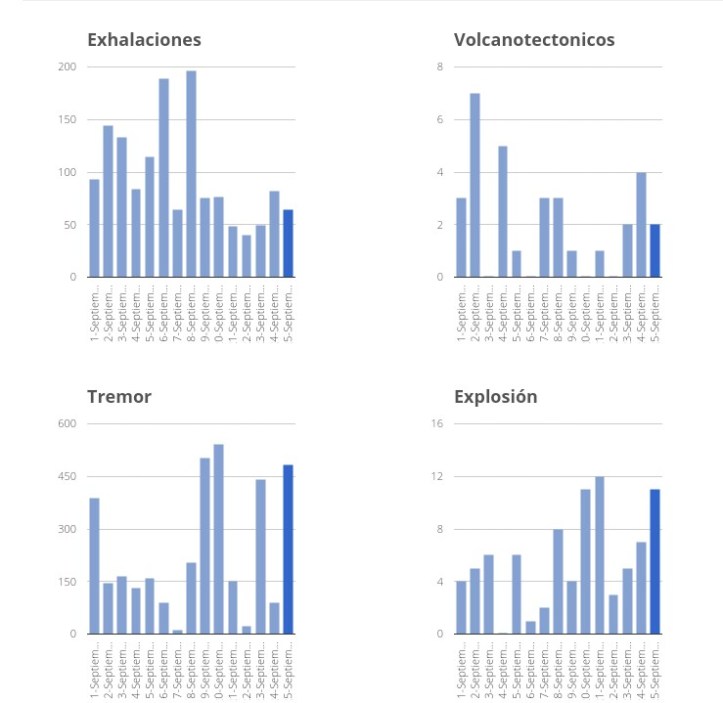
September 25, 11:00 h (September 25, 16:00 GMT)
In the last 24 hours, through the Popocatepetl volcano monitoring system 64 low intensity exhalations, accompanied by steam, gas and small ammounts of ash were detected, thwe most important events were recorder today at 09:07, 09:18 and 10:26 h (image 1 , image 2 and image 3 ). Also were registered eleven explosions, the most important events were ocurred yesterday at 11:51 and 12:16 h (video 1 and video 2 ) and today at 03:18 h (image 4 and image 5 ), this event generate a column between 2 km high with moderate ash content and fragments incandescent.
Additionally, were detected 484 minutes of low amplitude tremor and two volcanotectonic earthquakes, the first was registered yesterday at 18:36 h and the last one was recorder today at 05:59 h with respective magnitudes of 2.3 and 2.9.
At the moment of this report there is partial visibility towards the volcano in which the continuous emission of water vapor and other gases that disperse in a south-southeast direction (image 6) .
CENAPRED emphasizes that people SHOULD NOT go near the volcano, especially near the crater, due to the hazard caused by ballistic fragments . . . and in case of heavy rains leave the bottoms of ravines by the danger of landslides and debris flows.
The Volcanic Traffic Light Yellow Phase 2.
An interesting point, at least to this layperson, is that the tremor didn’t quiet down after the explosions as it often does. I’m guessing Don Goyo, instead of slowly pushing up lava to form a dome that sits there for a while, is actively extruding lava at a fairly high rate; it collects around the vent; and when the weight of the accumulated lava gets too much, boom! (lots of gas in the lava, too), even as more lava comes up.
Addendum: A lovely, though scary, view of one of yesterday’s plumes seen from Mexico City:
Explosión del #Popocateépetl – 11:51 h. Columna eruptiva superior a 2 km sobre el cráter; dispersión de ceniza hacia EdoMex. Informa #SkyAlert pic.twitter.com/84Wybetxr6
— OVI (@oviingemmet) September 24, 2018
https://platform.twitter.com/widgets.js
(Edited September 25, 2018, 7:05 p.m.)
September 24, 2018, 5:19 p.m., Pacific: OK, I’m wrong. A look at the Twitter feeds for Dr. Carlos Valdes, head of CENAPRED, and SkyAlert, quoting VAAC, shows that this has been going on episodically for a while, at least six hours, with ash fall reports. They haven’t raised the alert level.
Otra explosión en el volcán Popocatépetl. 17:26, altura 1.8km. Amarillo Fase 2. pic.twitter.com/ZMwMeruFg0
— Dr. Carlos Valdes (@CarlosMValdes1) September 24, 2018
https://platform.twitter.com/widgets.js
Area in red: ash reports. Area in yellow (which includes Mexico City): ash forecast. (Update: Per this story [Spanish], it won’t be in sufficient quantity to cause any risk.)
Mapa de dispersión de ceniza por la actividad del #Popocatépetl.
•Área en rojo: ceniza observada.
•Área en amarillo: pronóstico dispersión a 6 horas.Usar cobrebocas y barrer la ceniza depositándola en bolsas para basura.
Fuente: VAAC-NOAA. pic.twitter.com/DdF7V9EbAd
— SkyAlert (@SkyAlertMx) September 24, 2018
https://platform.twitter.com/widgets.js
Así la actividad del Volcán #Popocatépetl a las 18:07 hrs. Vista San Nicolás de los Ranchos #Puebla. Vía @jabed1 @Popocatepetl_MX
GiF pic.twitter.com/r5cdcjPj1x
— Webcams de México (@webcamsdemexico) September 24, 2018
https://platform.twitter.com/widgets.js
September 24, 2018, 5:10 p.m. Pacific: This morning’s bulletin wasn’t much of a change so I didn’t post it here. However, a look at the cams just now shows increased activity; thus far, CENAPRED hasn’t updated their website. I think this just began; it looks vulcanian (repeated relatively small-scale blasts instead of a big blow-out), but some people are going to get ashfall from this.
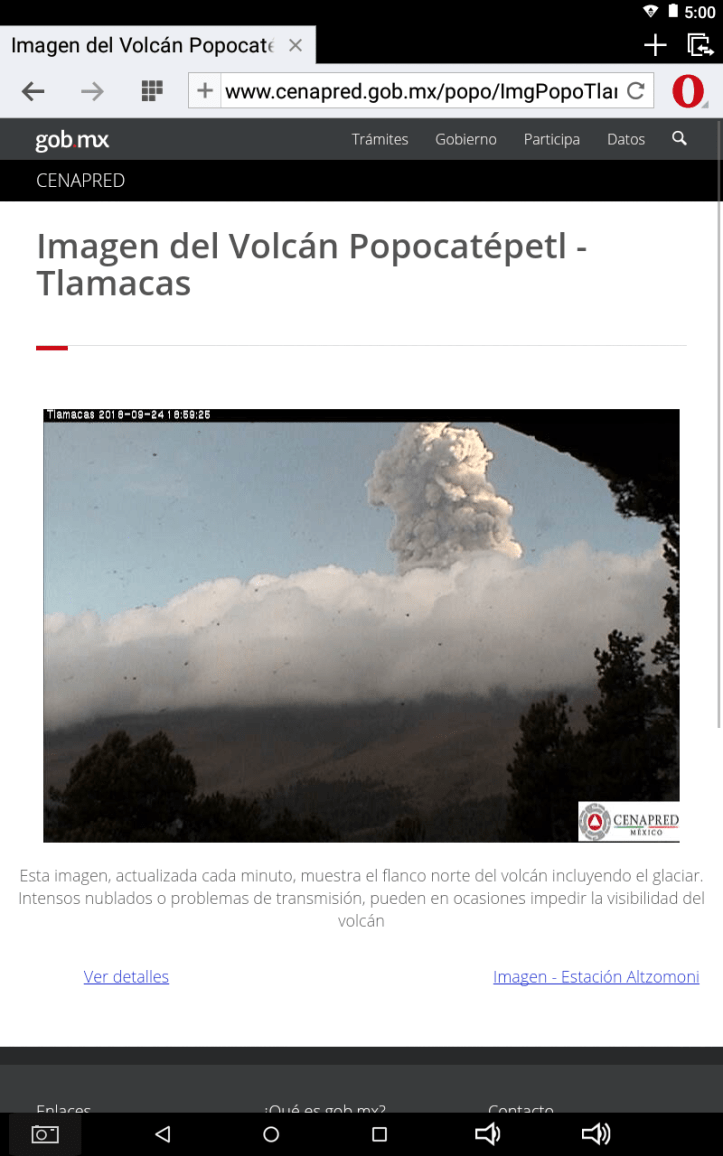
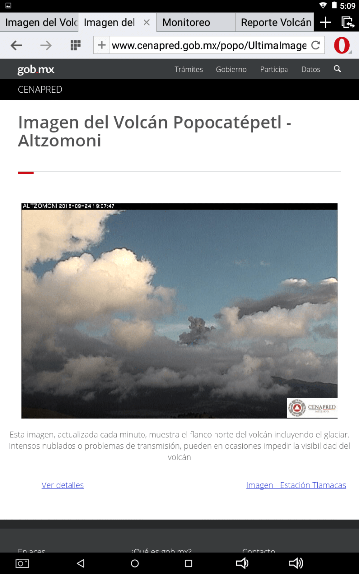
September 23, 2018: Not all of the Spanish-language bulletin today made it into the English version–parts in brackets are my own translation.

September 23, 11:00 h (September 23, 16:00 GMT)
In the last 24 hours, through the Popocatepetl volcano monitoring system 49 low intensity exhalations, accompanied by steam, gas and small ammounts of ash were detected. Also five explosions occured at 20:50 h, yesterday (image 1) [which threw some fragments over the north flank of the volcano and produced an ash column of 1.4 km above the crater], and today at 00:18 (image 2) , 00:37 (image 3) [with an ash column of 1.9 km], 06:35 h (imagen 4) and 09:29 h (imagen 5) . The emissions were dispersed towards west-southwest.
Additionally, 442 minutes of low amplitude tremor and two volcanotectonic earthquakes with preliminar magnitud of 1.9, were detected.
At the moment of this report the visibility is limited due to clouds; at earlier hours an emission of steam and gas was observed (image 6) .
CENAPRED emphasizes that people SHOULD NOT go near the volcano, especially near the crater, due to the hazard caused by ballistic fragments . . . and in case of heavy rains leave the bottoms of ravines by the danger of landslides and debris flows.
The Volcanic Traffic Light Yellow Phase 2.
September 22, 2018: Thankfully, Don Goyo has quieted down a bit, except for that one explosion.
September 22, 11:00 h (September 22, 16:00 GMT)
In the last 24 hours, through the Popocatepetl volcano monitoring system 40 low intensity exhalations, accompanied by steam, gas and small ammounts of ash were detected. Also three explosions occured at 14:11 (image 1) , 15:18 (image 2) and 20:23 (image 3) . The first one produced an ash column with height of 2.8 km above the crater. It was dispersed towards west-southwest.
Additionally, 21 minutes of low amplitude tremor were detected.
During the night incandescence and a continuous emission of steam and gas were observed (image 4).
At the moment of this report, an emission of steam and gas is present (image 5) .
CENAPRED emphasizes that people SHOULD NOT go near the volcano, especially near the crater, due to the hazard caused by ballistic fragments . . . and in case of heavy rains leave the bottoms of ravines by the danger of landslides and debris flows.
The Volcanic Traffic Light Yellow Phase 2.
September 21, 2018: Right now, the webcams are clear and Popo is breathtakingly incandescent under the bright moonlight. Pity these aren’t in color!

They also did an overflight today. See how the floor of the crater around that steaming hole is up close to the top of the walls? If an eruption produces a lot of material, there are going to be pyroclastic flows, because there’s no room inside the crater for it. (Learned about this in the “Challenges” paper linked above.)
September 21, 15:40 h (September 21, 20:40 GMT)
UPDATE
Today, with the aid of the Federal Police, a reconnaisance overflight of Popocatepetl##s crater was made . . . The volcano was actively emmitting a continuous plume of steam and gases that made observations difficult . . . Nevertheless, it could be seen that the inner crater remains the same size, and inside, the remains of dome 80, emplaced at the end of August and partially destroyed by the recent explosions, could be seen . . .September 21, 11:15 h (September 21, 16:15 GMT)
In the last 24 hours, through the Popocatepetl volcano monitoring systems were identify 48 low intensity exhalations accompanied by steam and volcanic gas, also twelve explosions at 11:11 . . . , 11:50 . . . , 12:10 . . . , 12:53 . . . , 13:02 . . . , 13:49 . . . , 14:31 . . . , 15:58 . . . , 16:12 h . . . , 04:36 . . . , 05:30 . . . and 09:18 h, additionally was recorder 152 minutes of tremor and one earthquake at 15:06 h with magnitude of 1.3.
During the night it was partially observed towards the volcano due to the high cloudiness . . .
At the time of this report, we have intermittent visibility to the volcano, we observe that the emission of steam and other gases were disperse in a west-southwest direction . . .
CENAPRED emphasizes that people SHOULD NOT go near the volcano, especially near the crater, due to the hazard caused by ballistic fragments . . . and in case of heavy rains leave the bottoms of ravines by the danger of landslides and debris flows.
The Volcanic Traffic Light Yellow Phase 2.
September 20, 2018: Don Goyo is restless.

September 20, 11:00 h (September 20, 11:00 GMT)
In the last 24 hours, the Popocatepetl volcano monitoring system identified 76 low intensity exhalations accompanied by steam, volcanic gases and small amounts of ash. . . Additionally, eleven explosions were recorded, yesterday at 13:42, 13:49, 15:17 . . . 17:18, 18:37 . . . , 19:08 . . . , 21:21 . . ., 21:28 y 23:35, and this morning at 01:48 y 03:17 h.
Also, 542 minutes of low-amplitude harmonic tremor were recorded.
At the time of this report, we have intermittent visibility to the volcano, we observe that the emission of steam and other gases and ash is dispersed in a west direction . . . .
CENAPRED emphasizes that people SHOULD NOT go near the volcano, especially near the crater, due to the hazard caused by ballistic fragments . . . and in case of heavy rains leave the bottoms of ravines by the danger of landslides and debris flows.
September 15, 2018: I haven’t been able to access the CENAPRED reports page, but the volcanic traffic alert signal is still Yellow, Phase 2. The webcams show some increased activity but nothing more than usual: incandescence at night, fuming and exhalations during the day, and occasional explosions.
September 11, 2018: Lots more tremor! Also, VT events up a bit.

September 11, 11:00 h (September 11, 16:00 GMT)
In the last 24 hours, through the Popocatepetl volcano monitoring systems were identify 93 low intensity exhalations accompanied by steam and volcanic gases (image 1), additionally was recorder 387 minutes of harmonic tremor, three volcanotectonic events, one yesterday at 17:34 h, and two today at 02:05 and 06:49 h, with magnitude Mc 1.4, 2.8, and 1.7 respectively and four explosions, two yesterday at 22:22 and 23:37 h and two today at 03:24 and 08:49 h. (image 2)
During the night was possible to observed incandescence which increase in some episodes (image 3).
At the time of this report, we have intermittent visibility to the volcano, we observe that the emission of steam and other gases were disperse in a north-northeast direction (image 4)
CENAPRED emphasizes that people SHOULD NOT go near the volcano, especially near the crater, due to the hazard caused by ballistic fragments . . . and in case of heavy rains leave the bottoms of ravines by the danger of landslides and debris flows.
The Volcanic Traffic Light Yellow Phase 2.
September 9, 2018: Both explosions and tremor up a bit over the last 24 hours. That’s a lot better than increased tremors and no explosions (which would mean pressure was building up).
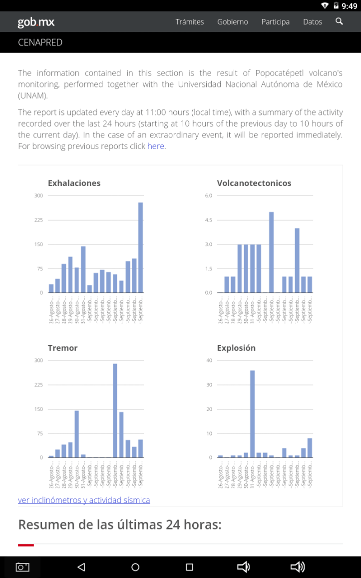
September 9, 11:00 h (September 9, 16:00 GMT)
In the last 24 hours, were identified through the Popocatepetl volcano monitoring systems 279 low intensity exhalations accompanied by steam and volcanic gases and eight explosions yesterday at 14:42 h, 16:02 h, 16:03 h, 16:30 h, 21:12 h and 23:32 h and today at 02:41 h and 05:45 h (image 1), (image 2), (image 3), (image 4), (image 5), (image 6), (video 1), (image 7), (image 8). Also, was registered one volcanotectonic earthquake yesterday at 19:11 h with magnitude 2.4. Additionally, were detected 56 minutes of harmonic and low amplitude tremor.
During the night we observed a gently incandecense which increase in some episodes (image 9).
At the time of this report, we have visibility to the volcano, we observe the emission of water vapor and other gases that disperse in a south direction (image 10), (image 11), (image 12), (image 13).
CENAPRED emphasizes that people SHOULD NOT go near the volcano, especially near the crater, due to the hazard caused by ballistic fragments . . . and in case of heavy rains leave the bottoms of ravines by the danger of landslides and debris flows.
The Volcanic Traffic Light Yellow Phase 2.
The scenarios foreseen for this phase are:
1. Explosive activity of low to intermediate level.
2. Ash fall in nearby towns.
3. Possibility of short range pyroclastic flows and mudflows .
Special emphasis is placed on the following recommendations:
1. Continue the safety radius of 12 km, so staying in that area is not allowed.
2. Keep the controlled traffic between Santiago Xalitzintla and San Pedro Nexapa through Paso de Cortés.
3. Civil Protection authorities, keep your preventive procedures, in accordance with their operational plans.
4. People, be alert to the official information disseminated.
In case of ashfall, address the following recommendations:
Cover nose and mouth with a wet handkerchief or face mask.
Clean eyes and throat with pure water.
Avoid contact lenses to reduce eye irritation.
Close windows or cover them up, and stay indoors as much as possible.
Popocatepetl Volcano monitoring is performed continuously 24 hours a day. Any change in activity will be reported in due course.
DMVEM
September 7, 2018: Will just share a graphic from this morning’s CENAPRED update, showing the gist–exhalations (those “puffs” Don Goyo gives off occasionally) and VT earthquakes up a bit, harmonic tremor decreased:

September 6, 11:20 h (September 6, 16:20 GMT)
In the last 24 hours, were identified through the Popocatepetl volcano monitoring systems 37 low intensity exhalations accompanied by steam and volcanic gases (image 1) (image 2) (image 3) (video 1) (video 2). Also, were registered yesterday an explosion ocurred at 14:01 h, today a volcanotectonic earthquake at 04:19 h with 1.7 magnitud and a total of 141 minutes of low amplitude tremor in this period.
During the night we observed a gently incandecense which increase in some episodes (image 4).
At the time of this report, we have visibility to the volcano, we observe the emission of water vapor and other gases that disperse in a norwest direction (image 5).
CENAPRED emphasizes that people SHOULD NOT go near the volcano, especially near the crater, due to the hazard caused by ballistic fragments . . . and in case of heavy rains leave the bottoms of ravines by the danger of landslides and debris flows.
Low-amplitude tremor back:
September 5, 11:20 h (September 5, 16:20 GMT)
In the last 24 hours, were identified through the Popocatepetl volcano monitoring systems 57 low intensity exhalations accompanied by steam (image 1) (image 2) (image 3). Four explosions were detectead, yesterday at 17:24 and 18:09 h, today at 01:12 h and 04:21 h. Also, a vulcanotectonic event was detected yesterday at 11:32 with a 1.6 magnitude. Finally, a total of 290 minutes of low amplitude tremor was recorded.
During the night we observed a gently incandecense which increase in some episodes (image 4).
At the time of this report, we have visibility to the volcano, we observe the emission of water vapor and other gases that disperse in a west direction (image 5).
No tremor mentioned in this bulletin–will go back to just keeping an eye on Don Goyo’s daily updates and the news and only post here when there is some notable change in activity or any shift of the volcanic “traffic signal” alert status. Glad the Colossus of Puebla has settled down a little!

September 1st, 11:20 h (September 1st, 16:20 GMT)
In the last 24 hours, through the Popocatepetl volcano monitoring systems, 24 low intensity exhalations accompanied by steam were identified (image 1). Additionally, 2 explosions were recorded. In addition, three volcanotectonic earthquakes were detected today at 05:28, 05:50 and 08:34 h, with magnitude of 1.4, 2.4 and 1.4 respectively.
During the night intense incandescence was observed above de crater (image 2) (image 3).
At the time of this report, we can see the continuous emission of volcanic gases in a northwesterly direction (image 4).
At the time of this report, there is no visibility, although earlier it was seen with a slight emission of steam and gas that the wind disperses to the west-southwest (image 7).
CENAPRED emphasizes that people SHOULD NOT go near the volcano, especially near the crater, due to the hazard caused by ballistic fragments (image 5) and in case of heavy rains leave the bottoms of ravines by the danger of landslides and debris flows.
The Volcanic Traffic Light Yellow Phase 2.
The scenarios foreseen for this phase are:
1. Explosive activity of low to intermediate level.
2. Ash fall in nearby towns.
3. Possibility of short range pyroclastic flows and mudflows .
Special emphasis is placed on the following recommendations:
1. Continue the safety radius of 12 km, so staying in that area is not allowed.
2. Keep the controlled traffic between Santiago Xalitzintla and San Pedro Nexapa through Paso de Cortés.
3. Civil Protection authorities, keep your preventive procedures, in accordance with their operational plans.
4. People, be alert to the official information disseminated.
In case of ashfall, address the following recommendations:
Cover nose and mouth with a wet handkerchief or face mask.
Clean eyes and throat with pure water.
Avoid contact lenses to reduce eye irritation.
Close windows or cover them up, and stay indoors as much as possible.
Popocatepetl Volcano monitoring is performed continuously 24 hours a day. Any change in activity will be reported in due course.
GVCJ
Much less harmonic tremor reported in this bulletin–not surprising, after 36 low-level explosions in five hours!
August 31, 11:20 h (August 31, 16:20 GMT)
In the last 24 hours, through the Popocatepetl volcano monitoring systems, 144 low intensity exhalations accompanied by steam were identified (image 1). Additionally, 36 explosions were recorded with light amounts of ash and volcanic gases (imagen 2) (imagen 3). In addition, three volcanotectonic earthquakes were detected today at 04:39, 06:06 and 07:06 h, with magnitude of 1.6, 1.7 and 1.54 respectively, and 10 minutes of low amplitude harmonic tremor.
During the night intense incandescence was observed above de crater (image 4) (image 5).
At the time of this report, we cannot see the volcano. But this morning we can see the continuous emission of volcanic gases in a westerly direction (image 6).
At the time of this report, there is no visibility, although earlier it was seen with a slight emission of steam and gas that the wind disperses to the west-southwest (image 7).
CENAPRED emphasizes that people SHOULD NOT go near the volcano, especially near the crater, due to the hazard caused by ballistic fragments (image 5) and in case of heavy rains leave the bottoms of ravines by the danger of landslides and debris flows.
The Volcanic Traffic Light Yellow Phase 2.
The scenarios foreseen for this phase are:
1. Explosive activity of low to intermediate level.
2. Ash fall in nearby towns.
3. Possibility of short range pyroclastic flows and mudflows .
Special emphasis is placed on the following recommendations:
1. Continue the safety radius of 12 km, so staying in that area is not allowed.
2. Keep the controlled traffic between Santiago Xalitzintla and San Pedro Nexapa through Paso de Cortés.
3. Civil Protection authorities, keep your preventive procedures, in accordance with their operational plans.
4. People, be alert to the official information disseminated.
In case of ashfall, address the following recommendations:
Cover nose and mouth with a wet handkerchief or face mask.
Clean eyes and throat with pure water.
Avoid contact lenses to reduce eye irritation.
Close windows or cover them up, and stay indoors as much as possible.
Popocatepetl Volcano monitoring is performed continuously 24 hours a day. Any change in activity will be reported in due course.
GVCJ
August 30, 2018: Volcano alert level unchanged, but I think it’s worth keeping an eye on and have set up this page, which is better for multiple updates.
Per CENAPRED this morning:
August 30, 11:00 h (August 30, 16:00 GMT)
In the last 24 hours, through the Popocatepetl volcano monitoring systems, 78 low intensity exhalations accompanied by water vapor and gas and a small amount of ash were identified (image 1). Additionally, two explosions were recorded today at 02:43 and 09:55 h (imagen 2). In addition, three volcanotectonic earthquakes were detected today at 03:18, 06:32 and 07:07 h, with preliminary magnitude of 1.8, 1.4 and 1.5, respectively, and 145 minutes of low amplitude harmonic tremor.
At the time of this report, there is little visibility of the volcano. If an ash emission were presented, it would have a west-southwest direction (image 3).
At the time of this report, there is no visibility, although earlier it was seen with a slight emission of steam and gas that the wind disperses to the west-southwest (image 4).
CENAPRED emphasizes that people SHOULD NOT go near the volcano, especially near the crater, due to the hazard caused by ballistic fragments (image 5) and in case of heavy rains leave the bottoms of ravines by the danger of landslides and debris flows.
The Volcanic Traffic Light Yellow Phase 2.
The scenarios foreseen for this phase are:
1. Explosive activity of low to intermediate level.
2. Ash fall in nearby towns.
3. Possibility of short range pyroclastic flows and mudflows .
Special emphasis is placed on the following recommendations:
1. Continue the safety radius of 12 km, so staying in that area is not allowed.
2. Keep the controlled traffic between Santiago Xalitzintla and San Pedro Nexapa through Paso de Cortés.
3. Civil Protection authorities, keep your preventive procedures, in accordance with their operational plans.
4. People, be alert to the official information disseminated.
In case of ashfall, address the following recommendations:
Cover nose and mouth with a wet handkerchief or face mask.
Clean eyes and throat with pure water.
Avoid contact lenses to reduce eye irritation.
Close windows or cover them up, and stay indoors as much as possible.
Popocatepetl Volcano monitoring is performed continuously 24 hours a day. Any change in activity will be reported in due course.
REP
August 29, 11:00 h (August 29, 16:00 GMT)
In the last 24 hours, through the Popocatepetl volcano monitoring systems, 112 low intensity exhalations were identified, accompanied by steam and gas (image 1).
Additionally, 47 minutes of low-amplitude tremor were recorded, three volcanotectonic seisms ocurred yesterday at 10:50, 18:36 and 21:18 h, with magnitudes of 2.0, 2.1 and 1.4, respectively. During the night visibility was limited, and slight incandescence could be perceived over the crater (image 2).
This morning the volcano has been visible, with an intermitent fumarole of steam and gases, which looks denser during the larger exhalations (image 3).
At the time of this report, there is no visibility, although earlier it was seen with a slight emission of steam and gas that the wind disperses to the west-southwest (image 4).
CENAPRED emphasizes that people SHOULD NOT go near the volcano, especially near the crater, due to the hazard caused by ballistic fragments (image 5) and in case of heavy rains leave the bottoms of ravines by the danger of landslides and debris flows.
The Volcanic Traffic Light Yellow Phase 2.
Original post (edited August 30, 2018):
They haven’t changed the status–tremor events like the one described in the CENAPRED bulletin (pasted below) happen around restless volcanoes. But I’ve been reading this article (it’s free, and the whole expert but nontechnical book on volcano hazards and communicating risk is worth downloading from Springer if you’re interested, or you can read it online).
It’s worth bringing this beautiful but dangerous volcano up again.
Per CENAPRED:
August 28, 11:00 h (August 28, 16:00 GMT)
In the last 24 hours, through the Popocatepetl volcano monitoring systems, 90 low intensity exhalations were identified, accompanied by steam and gas (image 1).
Additionally, 40 minutes of low-amplitude tremor were recorded, one volcanotectonic seism of magnitude 1.5 ocurred tonight at 00:57 h, and one explosion was detected, which could not be corroborated due to lack of visibility. During the night an intermitent fumarole was visible (image 2).
This morning the volcano has been visible, with an intermitent fumarole of steam and gases, which looks denser during the larger exhalations (image 3).
At the time of this report, there is no visibility, although earlier it was seen with a slight emission of steam and gas that the wind disperses to the west-southwest (image 4).
CENAPRED emphasizes that people SHOULD NOT go near the volcano, especially near the crater, due to the hazard caused by ballistic fragments (image 5) and in case of heavy rains leave the bottoms of ravines by the danger of landslides and debris flows.
The Volcanic Traffic Light Yellow Phase 2.
The scenarios foreseen for this phase are:
1. Explosive activity of low to intermediate level.
2. Ash fall in nearby towns.
3. Possibility of short range pyroclastic flows and mudflows .
Special emphasis is placed on the following recommendations:
1. Continue the safety radius of 12 km, so staying in that area is not allowed.
2. Keep the controlled traffic between Santiago Xalitzintla and San Pedro Nexapa through Paso de Cortés.
3. Civil Protection authorities, keep your preventive procedures, in accordance with their operational plans.
4. People, be alert to the official information disseminated.
In case of ashfall, address the following recommendations:
Cover nose and mouth with a wet handkerchief or face mask.
Clean eyes and throat with pure water.
Avoid contact lenses to reduce eye irritation.
Close windows or cover them up, and stay indoors as much as possible.
Popocatepetl Volcano monitoring is performed continuously 24 hours a day. Any change in activity will be reported in due course.
REP
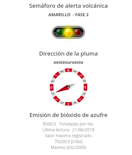
Later posts:
Featured image Popocatépetl in early 2019, by Puebla Civil Protection (Spanish)
