
What does North America’s Yellowstone have in common with South America’s Andes Mountains?
Supersized volcanism!
And spectacular although very different scenery, as shown here at Cerro Galan caldera, in northwestern Argentina.
I got into it this past week while working up the VEI 8’s post on Yellowstone’s magmatic plumbing (which, hopefully, will be ready at some point in the next week or two).

Sudowoodo/Shutterstock
It turns out that, between Yellowstone and those supervolcanoes in the Central Andes, Earth has been having an ignimbrite flare-up over the last 13½ million years and counting (Mason et al.) — just like the much older flare-up in the US West that we encountered last year in that one sabercat post.
Fortunately, you and I don’t need to go shopping for hardhats and bunkers just yet: these enormous eruptions can only be called “frequent” on a geological time scale.
Mason et al. found a minimum global frequency of 2 supereruptions per 1 million years over the last six million years.
Of course, that’s just on paper. In nature, supervolcanism seems to come in pulses at both Yellowstone and in the Central Andes, perhaps because of regional or global tectonic changes. (Mason et al.)
Pulses of supereruptions
This description of the Andean pulses, by Salisbury et al. is slightly [edited], with a little emphasis added for readability, and it has an added link; you don’t have to remember names or numbers — it’s just to show the sheer scale of the thing and to compare this “monster firehole course” in the Central Andes with Yellowstone:
The first major pulse was manifest at 8.41 Ma [million years ago] and 8.33 Ma as the Vilama and Sifon ignimbrites, respectively. During pulse 1, at least 2400 km3 of dacitic magma was erupted over 0.08 m.y. [million years; note that, to a geologist, even 10 million years is not a long time]. Pulse 2 involved near-coincident eruptions from three of the major calderas resulting in the 5.60 Ma Pujsa, 5.65 Ma Guacha, and 5.45 Ma Chuhuilla ignimbrites, for a total minimum volume of 3000 km3 of magma. Pulse 3, the largest, produced at least 3100 km3 of magma during a 0.1 m.y. period centered at 4 Ma, with the eruption of the 4.09 Ma Puripicar, 4.00 Ma Chaxas, and 3.96 Ma Atana ignimbrites. This third pulse was followed by two more volcanic explosivity index (VEI) 8 eruptions, producing the 3.49 Ma Tara (800 km3 [of magma]) and 2.89 Ma Pastos Grandes (1500 km3 [of magma]) ignimbrites.
There have been smaller eruptions there, too, both effusive (silicic lava flows) and explosive.
The most recent explosive volcanism in this “monster firehole course” happened some 90,000 to 100,000 years ago, in Bolivia and northern Chile, respectively. (Salisbury et al.)
🐋🐳🐋
The Altiplano is a plain because these pulses of ignimbrite thoroughly buried and smoothed over whatever Andean landscape and critters existed here back in the day.
It might have worked out for the Pacific’s whales, though:
This is just one of several, often very different hypotheses about how supereruptions might affect Earth systems.
🌋🌋🌋
For comparison, the current manifestation of the Yellowstone hotspot, known formally as the Yellowstone Plateau Volcanic Field —

Its informal names include “Jellystone.” (Image: Jacqueline F. Cooper/Shutterstock)
— has had three pulses over the last 2 million years (Christiansen et al.; LaMEVE; Watts et al.):
- Pulse 1 culminated in the Huckleberry Ridge supereruption; magnitude 8.3, 2.08 Ma, 939 km3 of magma, per current LaMEVE listing; the US Geological Survey says that Mount St. Helens erupted about 1 km3 of magma in the 1980s.
- Pulse 2 at Yellowstone ended with the Mesa Falls eruption; magnitude 7.8, 1.27 Ma, 280 km3 of magma
- Pulse 3: Lava Creek supereruption; magnitude 8.3, 0.63 Ma, 900 km3 of magma; it’s debatable, per Watts et al. whether Pulse 3 was the last or whether a fourth pulse has started with the rhyolite lava flow episodes, totalling at least 600 km3 of magma, that have occurred since the supereruption.
The last eruption at Yellowstone was when rhyolite lava flowed there a little over 70,000 years ago.
At the moment, we might be in between pulses at both places. Yay!
However, big magmatic systems like these are not completely understood, since the boffins can’t go down and take a look, and the gigantic systems operate over such long spans of time that useful data points are few and far between.
There are still plenty of unanswered scientific questions.
As well, most of us laypeople are fascinated and a little worried by supervolcanoes — what are they really like, and do we need to be concerned about them?
That’s the topic of the eBook I am working up this year.
For now, as a lead-in to the next Yellowstone blog post, let’s take a closer, though brief, look at volcanoes in the Andes — and the two places there, Uturuncu and Lazufre, where volcanologists have identified rapid, broad-scale uplift that conceivably could be related to supervolcanism.
“Normal” volcanoes and the “monster firehole course”
There are signs of an active inner life both at Yellowstone and at some Central Andean volcanoes and volcanic fields.
This is the Central Andean volcano Lastarria, located in a volcanic complex nicknamed Lazufre because of the two volcanoes in it named Lastarria and Cordon del Azufre.
Yellowstone, of course, is unusual because it is an intraplate hotspot.
In the Central Andes, most of the current volcanism is “normal.”
That is, it’s occurring in a subduction zone where the Nazca oceanic plate is diving underneath that ancient continental Brazilian craton which underlies, among other things, the Amazon Basin where margays and giant river otters cavort. (Salisbury et al.)
This subduction sets off “regular” Andean volcanoes like Lascar. (In North America, there is the Cascadia Subduction Zone west of the Yellowstone hotspot track, but as I understand it, those two geologic features are not directly connected.)
However, just east of this “regular” Andean arc — and for reasons that are currently under debate and also are way too complex for a blog post — sits that peculiar and impressive “monster firehole course ” formally called the Altiplano-Puna Volcanic Complex (jargon alert) or APVC.
It includes Cerro Galan and other supervolcanoes, like these.
Underneath it all is more than 500,000 km3 of magma: the world’s largest zone of silicic magma. (Hudson et al., 2023; Pritchard et al.)
For comparison, a 2015 study found Yellowstone to have about 10,000 km3 of magma in its upper magma chamber and about 46,000 km3 of magma in the lower chamber. (Huang et al.; University of Utah)
Please don’t let the term “magma” fool you.
Much of that hot stuff under the Altiplano-Puna region, just like the smaller but still supersized system at Yellowstone, is crystallized and not readily eruptible. (Gottsmann et al.; Pritchard et al.; Stelten; Unsworth et al)
Because no large accumulations of melt have been observed close to the surface over this Altiplano-Puna magma body, and also because the last APVC ignimbrite pulse faded away a long time ago, some experts suspect that this thing is slowly turning into a batholith, with intermittent magma intrusions from mantle sources keeping it hot but, for the most part, eventually freezing into various plutons. (Pritchard et al.; see their Figure 8, too)
It might be for this reason that De Silva and Self didn’t include any of these Andean calderas on the list of active supervolcanoes that we are using for the VEI 8 posts.
But volcanologists can’t completely rule out another ignimbrite eruption in the APVC. (Salisbury et al.)
Which is why they got very excited in the 1990s and early 2000s, when satellite imagery detected some rapid and broad-scale uplift at two sites there: Uturuncu stratovolcano at the APVC center, overlying the part of the melt zone called the Altiplano-Puna magma body, and in the 19-mile-long Lazufre volcanic complex near the Chile-Argentina border. Lazufre actually sits in the subduction volcanic arc, but it is also located on the edge of the part of that melt zone called the South Puna magma body. (Gottsmann et al.; Hudson et al., 2023; Pritchard et al.; Sparks et al.; Unsworth et al.)
Was a supereruption now brewing?
Starting in 2003 — when most of us were just starting to learn from tabloids as well as reputable sources like the BBC that Yellowstone is a supervolcano — geoscientists in South America and from around the world geared up and headed into the field to find out what was going on at the APVC and how hazardous it might be locally, regionally, and perhaps even globally. (Sparks et al.)
(Reassuring spoiler: Note that I’m referring to all this in the past tense.)
Cutting through the jargon
Before we get to what the boffins have discovered thus far, we must admit that they do not have x-ray eyes and cannot see through rock.
That magma body, after all, is down some 10 to 12 miles of more or less solid rock underneath the Altiplano-Puna surface. (Gottsmann et al.; Hudson et al., 2023; Sparks et al.)
What experts do have are instruments that can detect seismic waves, as well as other instruments that — believe it or not — can measure some of the underground electrical currents that are set off by natural sources like lightning and solar storms.
Soaked in jargon as I am, I can at least understand the general principle of what they’re doing, but as a layperson, I can’t clearly spell it out for you.
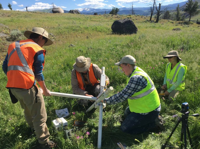
Volcanologists deploying a magnetotelluric station at Yellowstone. They also used MT to study Uturuncu and Lazufre, with results as shown in the upcoming video. (Image: Yellowstone Volcano Observatory, public domain)
Volcanologists can, and since they are using these same tools at Yellowstone and also are really into public outreach there, let’s explore the tech a little bit through two general-interest posts from the Yellowstone Volcano Observatory about:
- Seismic waves (tomography);
- And reading Nature’s electric meter with a technique called magnetotellurics (MT).
That’s the only jargon term I’ll use here, and it’s necessary because there is a video coming up that shows what the MT people found under Uturuncu and Lazufre.
Uturuncu and Lazufre
Uturuncu, the highest peak in southwestern Bolivia, is a stratovolcano and has had no caldera-forming eruptions yet. (Sparks et al.)
These young, healthy mountaineers are walking slowly up Uturuncu because the air is thin: they are almost 20,000 feet above sea level. It doesn’t look that high because the volcano sits on a 2½-mile-high plateau!
This dormant APVC volcano built itself up during the Pleistocene epoch with lava flows and lava domes, and it has slept for some 250,000 years, although there are still two sulfur fields and some fumaroles near the summit. (Hudson et al., 2023; Sparks et al.)
Geologists had been observing ground deformation at Uturuncu since 1965 (Gottsmann et al.), but this occurs at many volcanoes, and Uturuncu is remote and difficult to study.
The scale of that deformation only became apparent when satellite observations with InSAR became a thing in the early 1990s,
InSAR showed that ground for about 25 miles all around Uturuncu was rising at rates up to almost 1 inch per year. Not only that, for another 50 miles or so beyond the area of uplift, a “sombrero” rim of ground was subsiding. (Gottsmann et al.; Pritchard et al., including quote; Sparks et al.)
Some sources call this the most extreme example of known volcanic deformation in the world!
Then, in 1998, InSAR detected another area of uplift, about 25 miles in diameter, start, this time at the Lazufre complex. And beginning in 2003, a smaller area of ground around Lastarria volcano began to rise. (Pritchard et al.; Unsworth et al.)
Again, Uturuncu is in the center of the APVC, amidst a whole field of supervolcanoes, and Lastarria is right on the edge of that field. (According to Pritchard et al., experts are not certain how the magma sources for Andean arc volcanoes and the APVC interact, but those interactions probably do occur.)
Active volcanoes that are quiet for long stretches of time can be either inactive or recharging.
With no historic eruptions at Lazufre and none at Uturuncu for a quarter-million years, if they were recharging all that time, then a lot of magma might have accumulated underneath them by now, perhaps enough for at least one ignimbrite eruption. (Sparks et al)
Then again, since alternative hypotheses abound in geoscience, it could just be a sign that a couple of magma intrusions were underway and might eventually either freeze into plutons, along with the rest, or maybe set off a “normal”-sized eruption at Uturuncu and/or Lastarria or some other vent in the Lazufre complex.
Scientists really needed to see what was going on down there.
The PLUTONS project
Geoscientists organized various studies, including the PLUTONS project at Uturuncu and Lazufre, to find out.
Other field research was done as well, including a study of regional lake and river levels over geologic time, which are recorded as paleo-shorelines and terraces.
PLUTONS is over now, but papers based on the data that it and other networks collected, are still published; some of these, and other news, are available through the PLUTONS website.
Volcanologists have learned a lot about the Altiplano-Puna magma body, Uturuncu, and Lazufre, but it is impossible for me to detail it because that is still an ongoing and very technical debate, as far as this layperson can tell.
Getting to the point of most interest for us, it’s fortunate that lake and river levels are basically Nature’s surveying levels.
Geoscientists found that water level movements, recorded by the shorelines and terraces around Uturuncu over many centuries, equal out. Yes, that includes the current dramatic uplift, which apparently has been ongoing for no more than a hundred years. (Gottsmann et al.)
Accordingly, the ground deformation around Uturuncu should eventually reverse itself! (I think the experts are still investigating the why of it, but good news: no eruption seems to be on the way here right now.)
Seismic tomography shows some sort of a column that apparently rises under Uturuncu from the great magma body many miles below, but it doesn’t go all the way up to the volcano, and it most likely is filled with magmatic and water-based fluids and gases, not rising magma. No shallow large magma reservoir has been recognized under Uturuncu. (Gottsmann et al.; Hudson et al., 2023; Sparks et al.)
The situation is roughly the same at Lazufre, although here there might be a connection with melt-dominant regions — some magma is rising, as well as hydrothermal fluids. However, there is no identified large shallow magma body here, either, and long-term uplift here over the last hundred thousand years has formed a 30-mile-wide topographical dome. (Unsworth et al.)
Unsworth et al. also note that other areas, roughly 30 x 30 miles or more in size, are uplifting in the region, too. These aren’t associated with volcanic centers, and the researchers suggest that these might be plutons forming.
All sources that I have read agree that the situation still needs close monitoring, but it is clear now that no supereruption appears to be brewing at present.
Peering over the scientists’ shoulder
Most of us wonder what the boffins are seeing on their instruments and in rock exposures whenever we catch a glimpse of them at work in the field.
But when we look it up online, it’s gobbledegook to us.
This next video might also sound like gobbledegook to you, and I admit that when he got down to details about halfway through, he quickly lost me.
But it does show exactly what the scientists see on their screens and how they interpret it.
Background: Dr. Unsworth is the lead author of that paper listed in this post’s source list. The paper was published in 2023, bùt this video was uploaded in 2021 and apparently was recorded in 2020 during the pandemic, when so many of us all were working remotely.
Being geologists, it takes them a little while to focus strictly on the data. They get started on that at around the four-minute mark.
It is an MT specialist explaining his work to other MT specialists through a video, so JARGON ALERT!, but the pictures are the story for us.
They aren’t images made by numerical models which have been based on data but are only as good as the assumptions that were built into the models. (Bachmann and Huber; Wilson et al.)
This is from a 2015 model of Yellowstone’s plumbing (University of Utah) — visually impressive, reasonably accurate per YVO, but with built-in uncertainties.
Instead of model images, what Dr. Unsworth is showing us in the video below is the real deal; what their technology came into contact with under Uturuncu and Lazufre when they “read its electric meter.”
I find that tremendously exciting and hope you will too (but it does come with a major jargon alert):
The red areas on those graphics show where the good electricity conductors are down there. As we all know, liquids conduct electricity. So red areas on those images are liquids or partially molten material; the question for boffins is what kind of liquid it is: melt, magmatic fluids, or water-based fluids of some sort. And here is a link on flat-slab subduction, if you’re interested in the plate-tectonics aspect.
Summary
Geoscientists follow stricter rules than the rest of us: they are experts and therefore must be able to factually back up their statements and also let everyone know when they are speculating.
This is why they did not go shouting to the world that there might be a problem in the Andes around the turn of the century when they noted impressive ground deformation over the world’s largest known silicic (i.e., explosive) magma body, in a region that is absolutely littered with supervolcanoes.
This, even though supervolcanoes were all over the news at that point with reference to Yellowstone.
They just went and checked out the Central Andes region thoroughly. While they still don’t completely understand everything they found, they were able to establish that there were no likely supereruption precursors, since no large shallow magma chamber seems to have formed yet under either area of uplift.
Enhanced degassing from the Altiplano-Puna magma body might be responsible for deformation at Uturuncu. (Gottsmann et al.)
Whatever is going on at Lazufre could eventually lead to an eruption — likely “normal” in size, I think — or the rising magma there might just stall and harden into a pluton. (Unsworth et al.)
And, having settled the major question regarding hazard, they carried on with science and still do. There was no need to issue an “all clear” message to the rest of us since no warning had been necessary in the first place.
I think it’s important for us to be aware of the episode, though, both because it is very cool and because, next time, whenever and wherever, the findings might instead show that some serious trouble was on the way.
Or worse, we might get blindsided by a VEI 7 or 8 eruption at some mountain that had never shown danger signals during the whole instrumental era of the last 150 years or so — maybe nobody even realized that it was a volcano.
It isn’t always possible to know when Earth is about to throw a fit, but it always helps to know where we can turn to for reliable guidance.
It’s important for us to know who the experts are (geological surveys, volcano observatories, etc.); how (in very general terms) they know what they are talking about including the inevitable uncertainties that are involved; and what we can expect in the overall situation they might one day be warning us about.
Then, once we’ve got a handle on the scarier aspects of supervolcanism, we will also be able to wonder at the spectacular scenery that these giants leave behind after their rampage is over and they have gone back to sleep.
So now we laypeople know a little more about potential risks in the Central Andes (and, of course, at Yellowstone) and how they are monitored.
Let’s sit back, then, and enjoy the scenery.
It’s stark and rugged, but there is a surprising amount of life there:
And of course there are geologists tootling around —
Featured image: Robybenzi/Shutterstock
Sources:
- Bachmann, O., and Huber, C. 2016. Silicic magma reservoirs in the Earth’s crust. American Mineralogist, 101(11): 2377-2404.
- Bennington, N. 2026. An electromagnetic view of how magma is stored at Yellowstone. https://www.usgs.gov/observatories/yvo/news/electromagnetic-view-how-magma-stored-beneath-yellowstone
- Christiansen, R. L.; Lowenstern, J. B.; Smith, R. B.; Heasler, H.; and others. 2007. Preliminary assessment of volcanic and hydrothermal hazards in Yellowstone National Park and vicinity. U. S. Geological Survey.
- DeSilva, S. and Self, S. 2022. Capturing the extreme in volcanology: the case for the term “supervolcano”. Frontiers in Earth Science, 10: 859237.
- Gottsmann, J.;, Blundy, J.; Henderson, S.; Pritchard, M. E.; and Sparks, R. S. J. 2017. Thermomechanical modeling of the Altiplano-Puna deformation anomaly: Multiparameter insights into magma mush reorganization. Geosphere, 13 (4): 1042–1065.
- Huang, H. H.; Lin, F. C.; Schmandt, B.; Farrell, J.; and others. 2015. The Yellowstone magmatic system from the mantle plume to the upper crust. (Abstract only) Science, 348(6236): 773-776.
- Hudson, T. S.; Kendall, M.; Pritchard, M.; Blundy, J. D., and Gottsmann, J. H. 2022. From slab to surface: Earthquake evidence for fluid migration at Uturuncu volcano. Authorea Preprints.
- Hudson, T. S.; Kendall, J. M.; Blundy, J. D.; Pritchard, M. E.; and others. 2023. Hydrothermal fluids and where to find them: Using seismic attenuation and anisotropy to map fluids beneath Uturuncu volcano, Bolivia. Geophysical Research Letters, 50(5): e2022GL100974.
- LaMEVE entry for Yellowstone. 2026. https://vogripa.org/searchVOGRIPA.cfc?method=detail&id=1871 Last accessed May 8, 2026.
- Mason, B. G.; Pyle, D. M.; and Oppenheimer, C. 2004. The size and frequency of the largest explosive eruptions on Earth. Bulletin of Volcanology, 66(8): 735-748.
- Pritchard, M. E.; De Silva, S. L.; Michelfelder, G.; Zandt, G.; and others. 2018. Synthesis: PLUTONS: Investigating the relationship between pluton growth and volcanism in the Central Andes. Geosphere, 14(3): 954-982.
- Salisbury, M. J.; Jicha, B. R.; DeSilva, S. L.; Singer, B. S.; and others. 2011. 40Ar/39Ar chronostratigraphy of Altiplano-Puna volcanic complex ignimbrites reveals the development of a major magmatic province. Bulletin, 123(5-6): 821-840.
- Sparks, R. S. J.; Folkes, C. B.; Humphreys, M. C.; Barfod, D. N.; and others. 2008. Uturuncu volcano, Bolivia: Volcanic unrest due to mid-crustal magma intrusion. American Journal of Science, 308(6): 727-769.
- Stelten, M. 2022. Yellowstone’s magmatic system over the past 631,000 years. https://www.usgs.gov/observatories/yvo/news/yellowstones-magmatic-system-over-past-631000-years
- University of Utah. 2015. Scientists see a deeper Yellowstone magma. https://cmes.utah.edu/news/deeperyellowstonemagma.php
- Unsworth, M.; Comeau, M. J.; Diaz, D.; Brasse, H.; and others. 2023. Crustal structure of the Lazufre volcanic complex and the Southern Puna from 3-D inversion of magnetotelluric data: Implications for surface uplift and evidence for melt storage and hydrothermal fluids. Geosphere, 19(5): 1210-1230.
- Watts, K. E.; Bindeman, I. N.; and Schmitt, A. K. 2012. Crystal scale anatomy of a dying supervolcano: an isotope and geochronology study of individual phenocrysts from voluminous rhyolites of the Yellowstone caldera. Contributions to Mineralogy and Petrology 164.1 (2012): 45-67.
- Wilson, C. J.; Cooper, G. F.; Chamberlain, K. J.; Barker, S. J.; and others. 2021. No single model for supersized eruptions and their magma bodies. Nature Reviews Earth & Environment, 2(9): 610-627.
- Yellowstone Volcano Observatory. 2015. Using seismic waves to image Yellowstone’s magma storage region. https://www.usgs.gov/observatories/yvo/news/using-seismic-waves-image-yellowstone-magma-storage-region
