
Current status: As of February 11, 2025, at 2:57 a.m., Pacific, there is no eruption, but the Southern Volcanoes group reports on Facebook that (per Google Translate):
South Iceland Volcanology and Natural Hazards Group
Microseismic activity at Sundhnúkar now appears to be increasing. There has been very little activity in these areas since the end of the last eruption, but tiny earthquakes have been recorded from time to time. The accompanying picture shows the activity over the past week. The largest earthquakes are measuring between 1-1.5 in magnitude. Four of these earthquakes occurred last night, which can be said to be the greatest activity since the end of the last eruption in early December. The earthquakes last night occurred shallowly in the earth’s crust, from 1.5 km to 4 km. However, bad weather in recent days has affected the sensitivity of the measuring system, and it can therefore be assumed that more earthquakes have been recorded than those recorded.
Most recent blog post: November 20 to December 9, 2024.
They’ve had several different names since they began in 2021, mainly “Fagradalsfjall,” “Svartsengi,” or “Sundukhnur,” but I’ve decided that, on this blog anyway, “Reykjanes” is the best.
The whole Reykjanes Peninsula is composed of such volcanic systems.
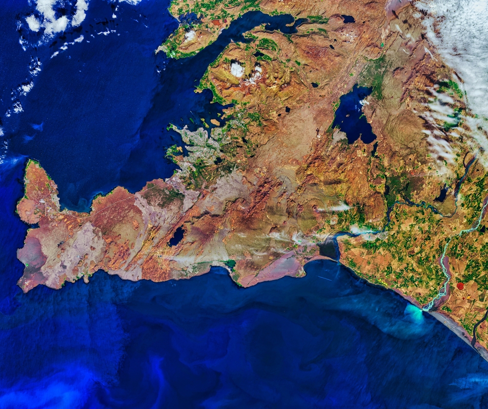
The volcanic systems run southwest to northeast snd are lined up like books on a shelf. (Image: Best Backgrounds/Shutterstock)
Since volcanologists agree that the peninsula is awakening after an eight-century nap, why not just call the entire episode (which will probably last for many decades or even a century or two) “Reykjanes”?
True, that might get a little confusing if and when an individual volcanic/geothermal system near the tip of the peninsula — a system that is also called Reykjanes — lights up.
But this is hardly the only confusing thing, for a layperson and outsider, about volcanism here. 😉
Setting and summary
Check the “Iceland” category at the bottom of this post for more blogging that has information, links, and references collected down through the years, particularly the recent three-part Iceland series.
Basically, the Reykjanes segment of the Mid-Atlantic Ridge rises above sea level here to become a peninsula as it meets and smooshes against the Iceland hotspot (whose center is inferred to sit several miles underneath Bardarbunga and its fellow volcanoes in south central Iceland).
It’s still a mid-ocean spreading ridge, though, and the boundary between the Eurasian and North American tectonic plates runs down the central Reykjanes Peninsula.
There are places you can visit on the peninsula, like the famous Bridge Between Continents —

Eric Salard, CC BY-SA 2.0
— where this boundary is stark, but overall it is visible only to experts who describe it as a rather broad zone of deformation.
Deformation causes pressure to build up along the boundary until, eventually, rocks at some relatively weak point give way and the distance between North America and Eurasia widens in a series of earthquakes.
This happened quite close to the important fishing port of Grindavik on the evening of November 10, 2023:
As the plate edges separated, an underground crack (a/k/a a dike) formed and magma — coming from a large sill under Svartsengi that had begun moving into the area in 2019 and was associated with the 2021-2023 Fagradalsfjall eruptions — now started to rush into that dike at a rate of thousands of meters per second.
That’s a Laki-style flood lava eruption rate and word was passed to clear out of Grindavik and nearby centers IMMEDIATELY.
Fortunately, the magma stayed underground in the dike and the situation soon stabilized.
Four days later, Grindavik residents were allowed to return briefly to get belongings and to check on their property —
— but it was not the same place any more.
Their hometown, particularly on its western end, was in between the two separating tectonic plates. A system of ground cracks that had first appeared during the big November 10th quakes continued to open new cracks unexpectedly. Some of these widened, and land in between the cracks slowly sank.
Icelanders do fight back against Nature.
Knowing what else was coming, if not when or where it would come, they quickly built big lava diversion walls — made out of old lava mined out of the plain or from adjacent hills — to protect Grindavik and the nearby Svartsengi power plant that provides geothermal heat and drinking water to tens of thousands of peninsula residents and businesses.
The barriers soon proved their worth.
On December 18, 2023, lava finally appeared when fissures opened near the millennia-old Sundukhnur craters a couple of miles north of Grindavik.
Since then there have been a series of fissure eruptions there and, beginning this past summer, at a site slightly more north along the dike, closer to remote Fagradalsfjall but also just two miles or so from the main Reykjavik-Keflavik highway. Experts say that topography will protect the highway from further eruptions for the time being.
Life goes on. Only one life has been lost: someone working on ground repair who fell into a deep crack. His body was never found, though not for lack of trying — rescuers went down as far as they could but those tectonic fractures are extensive and deep.
However, most homeowners in Grindavik have sold out to the state and moved elsewhere. It’s mainly a business zone now and one worth saving since Iceland has few harbors on its southern coast.
In terms of updates here at the blog, to make things easier I’ll just use this post and for a feature image use either a blank cam image screenshot from March 2024 when there were no eruptions or a screenshot from the ongoing fires.
I’ll also post one link at a time to cover the most recent eruption:
Edited December 11, 2024.
Updates
January 31, 2025, 3:05 a.m., Pacific:
A specialist at the #Icelandic Met Office says the next #eruption could be "tomorrow or in four weeks". He warns against travel to #Grindavík over the weekend as severe weather conditions could impact #seismic monitoring and possible #escape routes.https://t.co/kPAmy4KMd0
— RÚV English (@RuvEnglish) January 31, 2025
https://platform.twitter.com/widgets.js
January 25, 2025, 6:51 p.m., Pacific: Per the University of Iceland’s South Iceland Volcano and Natural Hazards Group (which I sometimes abbreviate as the Southern Volcanoes group), via Google Translate:
A lot of steam has risen from the new craters on the Sundhnúk crater series during today’s snowfall.
The steam is considered unusually high, but it is likely that weather conditions, i.e. cold, snow and humidity, play the biggest role in generating so much steam. However, it cannot be ruled out that the heat flow from below has increased somewhat with increased magma accumulation. The area has been very cracked after earthquakes in the last 18 months, and therefore there could be a clear path for hot gases to the surface.
Therefore, it is still predicted that the likelihood of magma intrusion and volcanic eruptions will increase towards the end of the month.
There has been little or no seismic activity in the eruption area in recent weeks. Yesterday, however, there were several small earthquakes in the middle of the crater row.
The photo was taken by Hafþór Skúlason at 15:40 today.
Status update: As of this writing, January 19, 8:36 p.m., Pacific, the University of Iceland’s Southern Volcanoes group reports that a change has occurred. (Facebook will translate the post, but if you can copy and paste, I’ve found that Google Translate is better with Icelandic.)
No landrise has been recorded recently. They are still expecting an eruption/dike intrusion around the end of the month to early February, per this post and online media articles, but it is always notable when significant changes happen during active volcanism, especially when that activity is underground and can’t be directly observed.
Time will tell how significant this change might be.
January 21, 2025, 10:37 p.m., Pacific: On January 21, IMO reported (autotranslated) that landris continues but has slowed down, and they are expecting another eruption or dike intrusion.
