Iceland’s Recent Fires — December 9, 2024, 1716 UTC
The former president of Iceland tweeted this image of work to raise the Svartsengi barriers after this ongoing lava flow (foreground) reached the top of those berms. The eruption plume is seen in the distance, while farther down the line steam rises where water cannons are cooling the lava surface in preparation for the workers.
A 360° drone view of the Sundhnuks, Grindavik, and Svartsengi area on August 7, 2024, with labels.
December 9, 2024, 9:16 a.m., Pacific: It’s official (autotranslated) — this eruption is over. And the sill underneath Svartsengi is inflating again.
December 4, 2024, 1:03 p.m., Pacific: No changes, per IMO this afternoon. Google translation of the text of their update (emphasis added):
There has been little change in the activity of the crater in recent days, and turbulence measurements support this conclusion. Lava flows from the active crater continue to flow mostly southeastward towards Fagradalsfjall.
There have been minor changes to the lava rim, but overall the advance of the lava rim is small. The crater continues to charge up, which increases the risk of it collapsing. If this happens, the lava could change direction, but given the location of the crater, infrastructure is not considered at risk.
Deformation data show that there is a balance between the flow of magma into the accumulation area under Svartsengi and the flow of magma to the surface from the active crater.
Gas pollution was measured at Húsafjall, east of Grindavík, over the weekend, but the prevailing northerly wind over the weekend led to gas reaching south from the eruption sites.
Those traveling in the area are encouraged to monitor the Icelandic Meteorological Office’s gas distribution forecast and instructions regarding gas pollution at loftgadi.is.
Risk assessment updated
The risk assessment has been revised and updated in light of the latest measurements and data. The main changes affect area 1 (Svartsengi) as the overall risk for the area goes from “considerable” risk (orange) to “some” risk (yellow). What influences this change is that there has been no lava flow towards Svartsengi in recent days. Area 6 goes from “high” risk (red) to “considerable” risk (orange) as the risk from pyroclastic flows is considered low. The risk from gas contamination remains high in areas 5 and 6, as well as area 3 where it is assessed as very high.
The risk assessment is valid until December 10, with everything remaining unchanged.
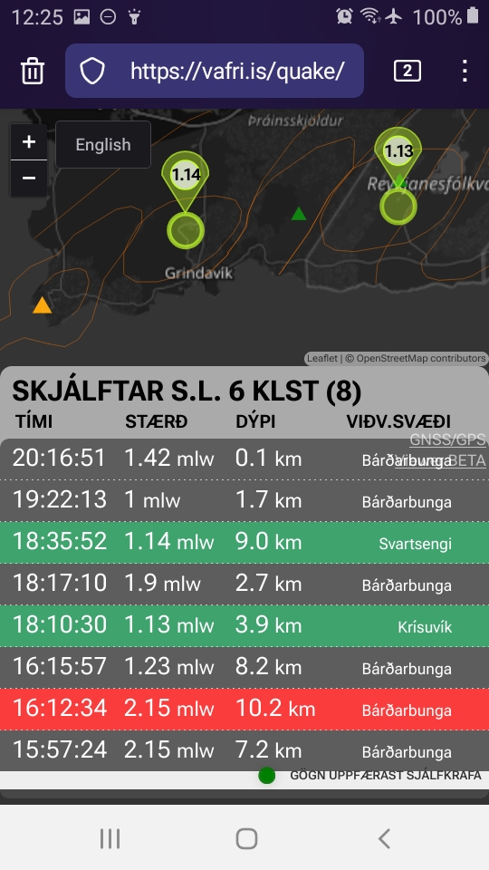
At the moment there is a 1-pointer showing up in the older eruption site area north of Grindavik on vafri.is —
— but most of the time that formerly active region is nice and quiet. Hope it stays that way!
November 26, 2024, 5:56 a.m., Pacific: The current geoscientist note on the IMO website sums up things succinctly (Google translation):
The eruption that started on November 20 at the Sundhnúks crater series, continues. The lava flow that has flowed west from the center of the craters has slowed down and cooled on the surface. However, it can still be expected that the lava flow will continue below the surface towards the defenses at Svartsengi and Bláa Lónið, even though its progress has slowed considerably. The northernmost crater is now the only active crater and from it the main lava flow now runs to the east.
Written by geoscientist on duty Nov 26 08:28
(Iceland times happens to be the same as UTC.)
Per mbl.is (autotranslated), decision-makers at the world’s most hardcore thermal spa are still reviewing their options about reopening.
November 25, 2024, 10:35 a.m., Pacific: It’s interesting: instead of the end vents dying out at either end and the central one(s) becoming the focus, IMO notes today (see Google translation below) that the two southern centers (closest to the old eruption series that threatened Grindavik) die out and the northern one — closest to the new site of eruption last time — continues.
The experts also note that lava flow is still considerable and apparently, while the flow has slowed down, the eruption’s end is not in sight:
Updated November 25 at 15:25
• The activity has not decreased as quickly as in previous eruptions
• The lava flows are the most powerful eruptions in Fagradalsfjall
• Lava flow can still put a strain on the dikes at Svartsengi
• Risk assessment unchanged
• Link to gas pollution forecast
From yesterday evening, the eruption turbulence and visible activity of the eruption decreased further, but the activity then stabilized again after midnight. However, there is still considerable force in the eruption and the activity has not decreased as quickly as in previous eruptions in the Sundhnúksgiga series. For comparison, it can be mentioned that the lava flow in the eruption at this moment is comparable to the lava flow in the most powerful eruptions in the most powerful eruptions in Fagradalsfjall.
…
The northernmost crater is the most active, and from it the lava flow now runs to the east. During the night, magma sputtered from time to time above the rim of the southernmost crater, but no activity has been seen in it today. The same applies to the central crater, which was the most active crater in the first days of the eruption, but activity in it significantly decreased yesterday and no activity is visible in it today in web cameras.
The lava flow that has flown to the west has slowed down and cooled on the surface. However, it can still be expected that the lava flow will continue below the surface towards the defenses at Svartsengi and Bláa Lónið, even though its progress has slowed considerably.
Experts from the Institute of Natural Sciences measured the spread of the lava on Saturday, when the eruption had been going on for about 3 days. According to those measurements, the total volume of lava was about 43 million cubic meters and it covered about 8.5 square kilometers of land. This is about 65% of the volume that erupted in the last eruption that lasted 14 days.
Land continues to subside in Svartsengi, but it has slowed down compared to the subsidence at the beginning of the eruption. It is still too early to say whether magma accumulation will continue under Svartsengi. The lava flow of the eruption needs to be further reduced before it can be said that magma accumulation will continue…
The power plant and its geothermal heat delivery system are holding. Here’s an update on that (autotranslated) from mbl.is.
This ambitious attempt to work with the lava, if it works, might help them cope with future lava threats.
There is also damage and more hazard to electricity transmission lines; while the rampart of at least one pylon has been reinforced, news reports say that the company is building a new pylon inside the Svartsengi barrier.
I somehow doubt that the Blue Lagoon will open to tourists on the 29th, as previously announced — not with all that work going on.
Reportedly they are reopening Grindavik again — earlier news reported that no concerning movement of the tectonic cracks occurred there as the eruption a few miles to the northeast started and has been continuing.
November 24, 2024, 8:38 a.m., Pacific: IMO reports today that the intensity of the eruption began to decrease around 5 a.m. today, local time.
That’s good news for people managing the potential overtopping crisis at the Svartsengi barriers.
By all accounts, the situation is under control, though lava is still up to the top of the ramparts in several places and water cooling continues (as I understand it, to raise the rampart, they must widen it first and they intend to do so over cooled lava; my speculation is that this also might help by performing the “squeeze” technique that stopped a flow overflow from the lava pond earlier this year).
However, I know from this chapter, that the scientists’ role is advice; instead, they broke the news about the Svartsengi crisis yesterday — when the PM and the media were not mentioning the threat, though they, too, must have seen the rising lava level — and only afterwards did public statements come out, including the not unimportant one that everyone in the district might lose their heat again.
It is probably relevant that Iceland’s parliamentary elections are next week.
So Icelanders are human after all. But I now know not to trust media reports there for all the reliable news — just some of it, when it suits major players’ convenience and/or affects immediate public safety.
You know — like here, and everywhere else.
November 23, 2024, 8:48 a.m., Pacific: Yesterday the prime minister said that they seemed to have escaped damage; this morning, I saw announcements that the Blue Lagoon would open on the 29th; and then, a few hours ago, both IMO and the Southern Volcanoes group posted that lava was putting pressure on the Svartsengi defenses and there was risk to infrastructure. RUV doesn’t have a story on it at the moment. (Update, 10 a.m., Pacific: They went live (autotranslated) about half an hour ago.)
I’m not sure what’s going on, but I believe the scientists. Will wait and see what develops.
Quick update: Of the three media I follow, only Visir mentioned the lava situation and they seemed to minimize it, in light of how Southern Volcanoes describes the situation on Facebook (Google translation):
A great deal of effort is now being made to strengthen the levees at Svartsengi. The lava flow has in some places reached the height of the levees, and the flow of lava from the eruption area has slowed down little. The activity in the eruption itself has been stable today, and the conditions are such that the largest lava flow from the eruption is directly west of Svartsengi. This is the same lava flow that overflowed the Blue Lagoon parking lot on Thursday. The situation is most serious at levee L3 (see aerial photo), but there is still more scope for improvement at other parts of the levee. Lava cooling is being prepared at the levees. The edge of the lava would be cooled over a section of several hundred meters with the aim of diverting the lava flow north from the levees.
Of note, Afar TV currently shows work on barriers (update: I now see that it’s the work building levees around electric power pylons threatened by lava in another area).
Mbl.is is currently streaming a closeup of the power plant area from Thorbjorn:
November 21, 2024, 11:09 a.m., Pacific: Well, a lot has happened — check out today’s Visir live updates (autotranslated), as well as the IMO, RUV, and mbl.is links above.
IMO reports that the fissure eruption is following the usual pattern, with fountains dying out at either end and remaining active in the middle of the 3-km-long fissure.
In brief, this lava is reportedly thinner and more mobile than earlier lavas. It has travelled farther west, inundating the Grindavik-Reykjavik road again, as expected, but also covering the new geothermal pipeline that replaced the one destroyed in February (the pipe’s insulation — a combination of concrete and packed basalt gravel, per earlier news stories — is holding up well thus far, per media reports).
Then lava actually circled round the rampart edge and unexpectedly came down from the north on the Blue Lagoon main parking lot and a building (the world’s most hardcore thermal spa was evacuated at eruption’s start yesterday and only emergency personnel are there today).
Workers were able to shut the berm entrance from the parking lot to the Lagoon/power plant complex in time and are currently raising that barrier level.
Also, lava cut a power line to Grindavik overnight. That is a separate circuit and there were no regional losses. The company switched over to generators and Grindavik got power again in a couple of hours, though some major commercial users might still be out (hard for a foreigner to tell from the online local media stories read via machine translation).
[Layperson speculation] This change in lava behavior, added to the new direction eruptive centers took last time AND the way the next to last eruption suddenly whiffed out at the craters north of Grindavik — it all makes me wonder if the Reykjanes Fires are beginning to tap another reservoir: the one that fed the “tourist eruptions” in Fagradalsfjall for a couple years.
While not all boffins agree, according to some sources those were fed from a deep source, possibly a mantle basalt lens, at the crust-mantle boundary.
That, I understand, is what’s called primitive magma. It’s hotter and its chemistry makes it flow a little more easily than some types.
The University of Iceland experts have probably sampled this currently new lava by now. It will be interesting to see what they report about it in their press release.[/layperson speculation]
November 20, 2024, 6:16 p.m., Pacific: Surprise! The eruption began about three hours ago, per the IMO (autotranslated).
It's in the same northerly part of the fissure November 2023 dike as the last one, and they note that it already seems to have peaked.
They also note that the precursors were not the same as before and that things appear to be changing.
This caught me by surprise at the end of an intense workday, so I’ll post a little more at some later point after catching up with the news. The IMO update is very detailed.
Quick update: There are no overnight updates yet on Facebook, and IMO notes that their next website update will be at 10 a.m., local time.
The Southern Volcanoes group notes that the fissure opened at the Sundhnuks craters and went northeast. IMO reports a length of 3 km before it stopped.
Lava headed for but has not reached the Grindavik road, and the town itself is not threatened.
Weather there has improved and Isak got out with his drone 🙂 :
November 19, 2024, 1:57 p.m., Pacific: Per Google translation of today’s IMO update (? why it translates into “Norwegian” instead of the actual name, “Icelandic”):
…It remains the opinion of the Norwegian Meteorological Agency’s scientists that it is unlikely that enough pressure will have built up to trigger an eruption in November. One of the things that supports that assessment is how little seismic activity is measured in the area. If the rate of landslides in Svartsengi changes or there is a significant increase in seismic activity, this estimate will change accordingly…
November 8, 2024, 7:16 a.m., Pacific: According to Google translation of today’s update, IMO considers an eventual eruption possible at a site anywhere along a 9-km stretch of the 2023 dike, which is coming up on its one-year anniversary, and they are installing more webcams. I see no change to Grindavik’s hazard assessment.
November 4, 2024, 9:22 a.m., Pacific: Per a geoscientist note on the IMO website today (via Google Translate):
Last night (4.11) there was an earthquake between Sýlingarfell and Stora Skógfell. The earthquakes were at a depth of about 4 km and the largest earthquake measured 1.2 in magnitude. The collapse was short-lived and neither the deformation data nor the borehole data showed any signs.
That’s not great news, even though the precursors of an imminent eruption (ground deformation and changes in that Svartsengi power plant borehole) were not seen.
This swarm is in the same general area as previous eruptions, which occurred just northeast of Grindavik. It’s concerning to this layperson because:
Lava is already up to the top of Grindavik and power plant diversion walls and it overtopped the walls in places during earlier eruptions — new flows from those old sites likely will not be completely diverted.
Last time, officials warned of power plant disruptions — then the new vents farther north, and out in the boonies (more or less), opened and took the hazard away. What had already erupted nearby continued to ooze for a while but didn’t even cross the road between the eruption site and the power plant.
Since then, Grindavik has opened (they took access barriers down); it’s mostly just for business, but the fishing operations and supportive businesses are active and some of the town’s damage is being repaired. As part of that process, the usual highway route between north and south peninsula areas is functional — cross-country shipping and tourists no longer must take the longer coastal route to get to Grindavik’s port and various travel destinations including the Blue Lagoon (which I now think of as the world’s most hardcore thermal spa 🙂 ).
Since the last eruption, seismicity has been farther north, too, even into the Fagradalsfjall and Krysuvik areas (some say Fagradalsfjall is a part of Krysuvik but let’s not visit the intricate world of academic views of the Reykjanes Peninsula volcanic systems right now).
Then a few quakes were reported in the Sundukhnur area, but it wasn’t much. On an unrelated note, volcanologists reported in both media interviews and official updates that the next eruption could happen by the end of November and that it could be up to 30% larger in volume.
The uncertainty in timing AND location always was stressed in these articles, but the lava barrier construction crews left Grindavik, reportedly, last month; Benedikt at IMO was quoted as saying that the last eruption occurred a couple miles away from the Reykjavik-Keflavik highway and, with a valley in between, another eruption there likely would not threaten the road; there were some stories about discussions on alternative airport locations; and just generally, it seemed to me that concerns shifted north along with the last active vents.
But as far as anyone knows, there is no reason why another eruption couldn’t happen at the earlier Sundhnuks location again.
Emergency managers and all other authorities and experts have kept this in mind and told everyone going to or already in Grindavik that they are responsible for their own safety, and that evacuation and other measures can be restored at any point.
The recent swarm now raises a possibility that all this might be necessary.
Again.
With an eruption that could be almost a third larger than the last one (which was the largest in the series thus far).
Sigh.
Well, let’s wait and see if IMO changes its current hazard assessment (in these posts I haven’t gone into the challenges that keeping people in Grindavik and at the power plant area, necessary as that is, poses for volcano hazard monitoring and mitigation because, as with the lava diversion efforts, the Icelanders are pretty much breaking new ground here; undoubtedly it will be the topic of many future papers and theses).
October 10, 2024, 11:46 a.m., Pacific: Here is IMO’s update today — still a waiting game, but as they note, in the past slowdowns have occurred before eruptions (because there is little room in the reservoir at that point for new magma):
Magma accumulation under Svartsengi continues
10.10.2024
Updated October 10 at 3:30 p.m.
• GPS measurements show evidence that the rate of land erosion in Svartsengi is slowing down slightly
• Model calculations, based on the GPS data, show that the magma influx under Svartsengi has decreased slightly
Low seismic activity in the Sundhnúks crater series
• The risk assessment is valid until October 17, all things being equal
GPS measurements in the Svartsengis area show evidence that recently the speed of the land giant has gradually decreased. Model calculations based on the GPS data also show evidence of a slight reduction in magma inflow beneath Svartsengi.
…
At the moment, these are small changes, and in the past there have been similar changes in the speed of magma accumulation a few weeks before the last eruptions. The measurements will be closely monitored in the coming days and weeks, which will help in interpreting and predicting the possible development of the events.
At this point, there is nothing in the Norwegian Meteorological Agency’s data that indicates that the accumulation of magma under Svartsengi will stop in the near future.
Since the last eruption (September 5), there has been little seismic activity in the Sundhnúks crater series, but only about 40 small earthquakes have been recorded there. At the same time, there has been equal activity in the western side of Fagradalsfjall, where up to 400 small earthquakes have been recorded (<M1.5), most of them at a depth of 6-8 km. This micro-seismic activity has been ongoing since the earthquakes began in the Sundhnúks crater series.
The question: if there is an eruption, will it happen at Skogafell again, back in the old Sundhnuks crater area, up at Fagradalsfjall again, or somewhere new?
September 27, 2024, 10:53 a.m., Pacific: There are no new reports of volcanism, but a new study reportedly finds that the Reykjanes eruptions are coming from multiple different reservoirs.
This sounds new to those of us used to the traditional volcano diagram showing a single big chamber underneath a volcano, but the layered structure has been documented at many fire mountains.
According to that linked press release from the University of Iceland, it’s the first time such plumbing structure has been reported in Iceland.
I don’t what the finding will do to the traditional interpretation of the Reykjanes Peninsula as a set of volcanic systems.
September 24, 2024, 12 p.m., Pacific: Today’s update from IMO also mentions magma movement at Fagradalsfjall and notable low-level seismicity at Trolladyngja, but no ground deformation:
Magma accumulation continues under Svartsengi
The last eruption was the largest in the Sundhnúks crater series
24.9.2024
Updated September 24 at 1:15 p.m
Landris continues at a similar pace
The total volume of the last volcanic eruption was over 60 million m3
Low seismic activity around the Sundhnúks crater series in recent weeks
Data from GPS meters show that landris in Svartsengi continues to be measured at a constant rate. Model calculations based on that data also show that magma accumulation under Svartsengi has continued at a similar rate in recent weeks. According to the measurements of the land mass and the estimate of the rate of magma accumulation, the development is similar to previous events in the area.
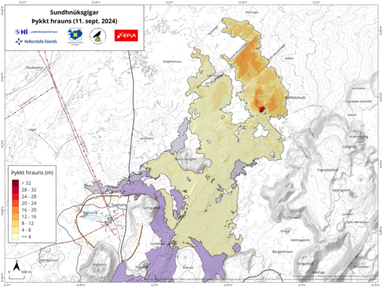
The imaging team of the National Institute of Natural Sciences and Land Survey of Iceland has processed data collected by Efla experts during a drone flight over the eruption centers on September 11. The data shows that the lava bed formed in the last eruption (August 22 – September 5) was 61.2 million m 3 and 15.8 km 2 in area. The data shows that the last eruption was the largest in the Sundhnúks crater series since December 2023. The thickest part of the lava bed is located around the crater, which was active the longest.
Map showing the extent and thickness of the lava bed formed in the last eruption. The map is based on Efla’s measurements and processing of data from the Natural Science Foundation. Gray areas show lava that has flowed in the area since December 2023.
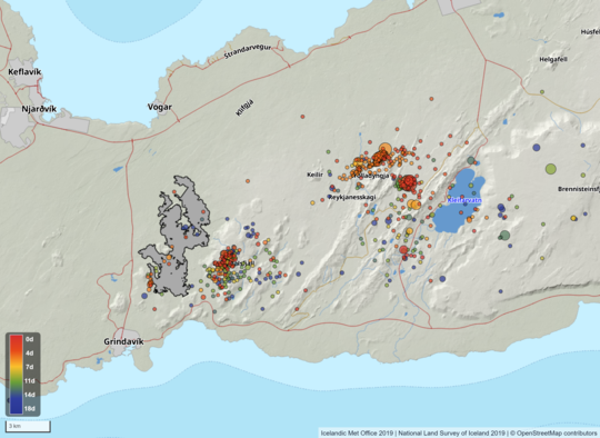
Earthquake activity has been low for the last two weeks at the Sundhnúks crater series. However, there has been some activity in the western side of Fagradalsfjall at a depth of 6-8 km since the eruption ended on September 5. There has also been considerable activity in Trolladyngja in the last few days. Most of the earthquakes in the area are small, but the largest was measured as M3.0 on September 22 just east of Trölladyngja. No deformation is measured in the area of Trolladyngja.
Map showing seismic activity on the Reykjanes Peninsula from September 6 to 24. The map also shows the outline of the lava bed formed in the last eruption. The contours of the lava are based on Efla’s measurements and processing of data from the Institute of Natural Sciences.
September 13, 2024, 12:34 p.m., Pacific: There is no change — just wanted to pass along a post (Facebook translation) from the Southern Volcanoes group, with emphasis added:
Landris has now been constantly at Svartsengi for the last week and clear signs are seen on GPS meters in the area after the eruption ended. As before, this is a sign of mercury collection based in the earth’s crust. The speed of landslides is similar to between volcanoes in recent months. At this point, however, it is too early to say when it will happen again, but it can be assumed that it will be a few weeks or months.
Let’s hope, if it happens in the cold depths of winter, that either the lava doesn’t cut geothermal pipes again or that the new backup heat source on the Keflavik peninsula, out of harm’s way, is online and adequate!
September 7, 2024, 1:09 p.m., Pacific: IMO called the eruption yesterday (via Google Translate):
September 6 at 9:30am
• No visible activity in the craters for about half a day
• The last signs of volcanic unrest were seen yesterday afternoon
• The eruption lasted for about 14 days
• Landris has started again in Svartsengi
• Risk assessment will be updated later today
The eruption north of Stóra-Scógfell is over. The eruption lasted for about 14 days.
This was the third longest eruption of the six that have occurred in the Sundhnúks crater series since December 2023. The eruption that began in mid-March lasted for about 54 days, and the eruption that began at the end of May lasted for about 24 days.
…
Landris is measured in Svartsengi and magma has therefore begun to flow into the magma chamber again. It is too early to state the rate of magma accretion, but initial model calculations suggest that it is similar to before.
They also note that this was the largest flow in the series that began in December 2023, although weather conditions have prevented them from getting measurements for a specific volume/area estimate.