Eldey, Catalogue of Icelandic Volcanoes (just in case)
RUV (autotranslated front page; they aren’t live at the moment (1902 UTC) but here is the last liveblog in English, too; and here is the autotranslated last Icelandic liveblog. Links may change, so on the front page look for a red box with white dots flashing and please be aware that autotranslation might not carry over when you click it; I use either browser translation or Google Translate online).
RUV, MBL.IS and Visir have live cams at their YouTube channels.
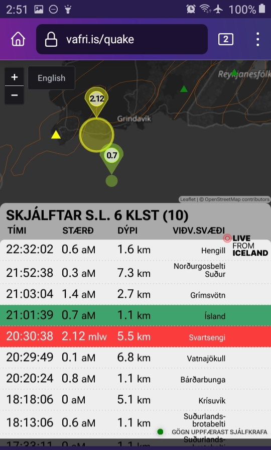
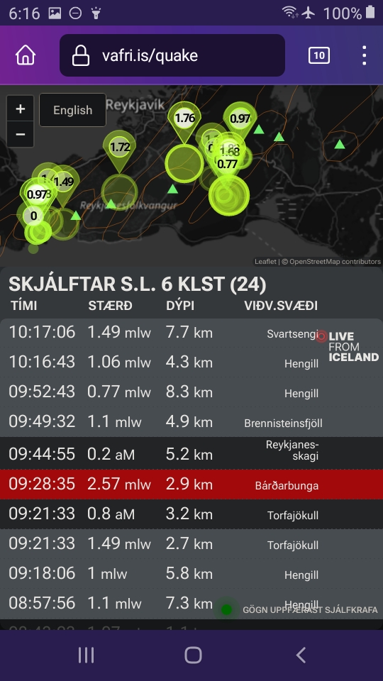
March 12, 2024, 10:22 a.m., Pacific: IMO’s latest update says pretty much what the earlier ones have but notes that there is more than 13 million m3 of magma underneath Svartsengi and that the sill continues to inflate.
Of note, there is a swarm ongoing in the Eldey region and at least one 1-pointer west of Grindavik.
I have no idea what it means but wonder if the magma is trying to move west. That would be good news, if so, because of the fewer people and less infrastructure around the peninsula tip.
If there is water contact during the process, though, ashfall might be problematical inland (and perhaps overhead?).
If…
March 12, 2024, 4:53 a.m., Pacific: The only news is that there is no news (autotranslated), despite continued uplift, i.e., magma inflow under Svartsengi.
Strictly as a layperson I did some speculating at TalkWeather yesterday.
The wait goes on.
March 8, 2024, 2:26 p.m., Pacific:
About two hours ago, an M2.8 happened slightly less than a mile north of Grindavik:
Also, IMO posted a report on the March 2 dike intrusion:
Model calculations show that the magma tunnel that formed on March 2 was about 3 km long and reached from Stóra-Scógfell to Hagafell. The map below shows its location according to these accounts.
The magma in the tunnel lies at a depth of 1.2 km where it is shallowest and reaches a depth of about 3.9 km. According to the model calculations, about 1.3 million cubic meters of magma flowed into the Sundhnúks crater series during the March 2 magma flow. There is a much smaller amount of magma than in previous events, but model calculations show that around 10 million cubic meters (or more) flowed from Svartsengi into the Sundhnúks crater series.
…
All things considered, the magma looks for the easiest way to the surface, and it’s hard to say what prevented it this time. It could be some obstruction in the flow of the magma, not enough volume or pressure to open a fissure, or even a combination of these factors.
The magma flow on March 2 behaved differently than previous magma flows during the summer and is a reason to study it further in order to further increase the understanding of the nature of magma flows in the region and to understand what the continuation of the events will be.
Looking at the history of other volcanic eruptions, it is not uncommon for a magma flow to end without an eruption. During the 10-year period in connection with the Kraflu fires 1975 – 1984, there were 20 magma flows and 9 of them ended with an eruption. The magma flows from Svartsengi to the Sundhnúks crater series have become 5 in number since November 2023, and 3 of them have ended in eruption. However, nothing can be said at this stage that the sequence of events on the Reykjanes Peninsula will behave like the upheaval in Krafla in this regard.
Of note, now they are saying this isn’t the same sort of thing as the Krafla Fires of the 1970s and 1980s. Probably they are just talking in terms of proportion of eruptions to just dike intrusions.
Also, I think they mean that the sill continues to inflate, not that most of its contents migrated to the Sundhnuk crater area — that would have been a massive seismic event, right?
Well, time will tell.
Right now the only lights showing north of Grindavik on the RUV mosaic cam are those that the barrier workers use (some were on all night during the recent bad weather!).
Let’s hope it stays that way.
March 6, 2024, 10:36 p.m., Pacific: There was a 2-pointer a couple of hours ago in the Keilir section near Krysuvik:
Keilir is the site of the last Fagradalsfjall eruption, a year ago (Litli Hrutur).
Also, mbl.is has turned their Keilir cam on (some six hours before the 2-pointer), though there is no indication that anything is likely to break soon — there or elsewhere.
However, RUV notes (autotranslated) that it was a quiet night seismically.
When the Fagradalsfjall “touristy” eruptions were active, things did quiet down just before an eruption.
So everyone is watching the situation a little more closely today, for sure.
I saw this on Twitter, posted 17 hours ago;
Til vinstri: Staðsetning skjálfta 100 daga fyrir myndun kvikugangsins 10. nóv sem náði m.a. undir Grindavík.
Twitter translation of the third post in that thread: “The latest tremors appear to be closer to the pre-November 10 pattern. The magma tunnel has become unrecognizable.
But it can change like so many other things in life.”
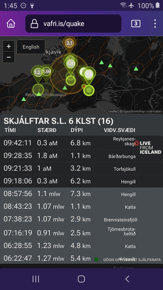
March 6, 2024, 7:28 a.m., Pacific: IMO spokespeople today focus on the November 10th dike, which has been very quiet, and the agency’s March 5 update is still in force, even though seismicity closer to Grindavik has gotten interesting, with a 2-pointer east of town on the 4th (note that these screenshots are from the unreviewed list):
A 2-pointer west of town on the 5th:
And a 3-pointer this morning that an IMO source is quoted as saying (autotranslated) was unrelated to the Grindavik system:
With constant magma flow into the sill and apparently no escape route to release pressure, this series of really just barely moderate-intensity earthquakes is not surprising, but why are they in this location, on either side of a rift zone that runs through Grindavik, I wonder.
We will just have to wait and see. In the meantime, here is a broad-scale map of the cracks in that town:
March 5, 2024, 3:40 a.m., Pacific: Per IMO’s new update, the Fagradalsfjall system has shown more seismicity than Svartsengi has since the recent dike intrusion.
It is doing so now, though very very mildly at the moment:
They also note that weather conditions will affect the sensitivity of the field monitoring equipment, and they continue to note that a dike intrusion and/or an eruption is possible with less than 30 minutes notice.
March 4, 2024, 2:40 p.m., Pacific: Per IMO’s update today, eruption could happen pretty much any time now:
Updated March 4 at 1:30 p.m
Probable sequence of events for the next few days:
• The volume of magma under Svartsengi continues to increase, which could result in a new magma flow and even an eruption
• An eruption could start at very short notice, even less than 30 minutes
• An eruption is most likely to occur in the area between Stóra-Skógfell and Hagafell
Model calculations show that the amount of magma that flowed on Saturday from Svartsengi into the Sundhnúks crater series was about 1.3 million cubic meters.
Previously, it had been calculated that around half a million cubic meters of magma accumulates under Svartsengi in a 24-hour period. All things being equal, the total amount of magma under Svartsengi will be around 9 million cubic meters by the end of the day tomorrow, Tuesday.
In previous events, magma has flowed when the total amount of magma accumulated under Svartsengi is between 8 and 13 million cubic meters. Therefore, there is an increased probability of a new magma flow and eruption once that amount has been reached.
However, it can be pointed out that after repeated eruptions in Fagradalsfjall, there were examples of magma creeping up to the surface without much seismic activity. It has to be assumed that it could be the development with the activity on the Sundhnúks crater series.
On the cams, there is steaming on the February flow, which is still hot, in various spots after it rains but no sign yet of new volcanism:
There is a 2-pointer noted a little west of Grindavik on the unreviewed quake list but, for most of the day, things were quiet when I checked.
We’ll see what, if anything, develops from that.
March 3, 2024, 3:25 a.m., Pacific: Here’s the latest IMO update:
The probability of an eruption continues to increase
Magma continues to accumulate under Svartsengi
3.3.2024
Updated March 3 at 10:20 am
Seismic activity at Sýlingarfell due to a magma run that started around 4 pm yesterday subsided steadily after 6 pm and was mostly over after 8 pm.
Data indicates that yesterday’s magma flow stopped at Hagafell. The likelihood of magma eruption associated with this magma flow has decreased, but the area will continue to be closely monitored for that possibility.
Model calculations show that the amount of magma that flowed from Svartsengi yesterday was insignificant compared to previous magma flows that ended in eruption. Therefore, it can be considered that magma accumulation continues under Svartsengi as before.
It is to be expected that another magma flow can occur in the next few days and there is an increased probability of a volcanic eruption, similar to yesterday’s sequence of events. How far to the next magma flow depends on how quickly the pressure due to the accumulation of magma under Svartsengi builds up to set it off. Signs of a new magma flow would be similar to the previous intensity of small earthquakes in the area.
In light of this, the Norwegian Meteorological Agency is working on a new risk assessment that will be updated in the next few hours.
Probable sequence of events for the next few days:
The volume of magma under Svartsengi continues to increase, which could end up with a new magma flow and even an eruption
An eruption could start at very short notice, even less than 30 minutes
An eruption is most likely to occur in the area between Stóra-Skógfell and Hagafell.
Jon Frimann has a blog post that is especially interesting in light of yesterday’s quote from Magnus Tumi:
This is a bit early, but it seems that this dyke intrusion moved or changed the rift valley it happened in. This rift valley was created in the dyke intrusion on 10. November 2023… It might also have moved the rift valley that was created on 14. January 2024… This rift valley situation is making the geology in this area extremely complex and volatile. Since the crust, the top layer is extremely fractured in areas of the rift valley and that makes it easy for the magma to find a path to the surface.
March 2, 2024, 9:57 a.m., Pacific: Per IMO’s new update, it sounds as though this is going to be a loooong, draaawn-out crisis:
Updated March 2 at 16:30 The news is updated
• The seismic activity has decreased. It is uncertain where the continuation of the activity will be. The earthquake began at 15:55 at the southern end of the fissure, where it erupted on December 18, 2023.
• The seismic activity moved southeast along the magma tunnel and stopped at Hagafell.
• The deformation that is currently being measured is much smaller than has previously been measured on the eve of a volcanic eruption. It could indicate that less magma is on the move now than in previous eruptions.
• The depth of the seismic activity does not indicate that magma is making its way to the surface as it is now. It is therefore less likely that the magma intrusion will lead to an eruption, but it is by no means excluded.
• One of the scenarios that has been mentioned is that there is a magma flow without an eruption.
Update, 11:10 a.m., Pacific: Magnus Tumi went up and took a look. From the Visir interview (emphasis added):
…
The earthquake seems to be looking south, do you think the magma intrusion is moving closer to Grindavík?
“It’s hard to say if it’s on that path. There were some tremors there. It is probably as if the magma is looking for a way to the gates. Nothing can be ruled out at this point. We will have to see what happens until this event is over. Whether it ends with a volcanic eruption and where it is,” Magnús Tumi said.
“It could be directly at Sýlingarfell, where the lava flow is, it could be further north, and it could also be further south, more towards Grindavík. These are the possibilities and at this moment there is no telling if it will end up erupting and where it will go. This longer time suggests that the swarm is looking for its way to the gates,” he concluded.
March 2, 2024, 8:33 a.m., Pacific: That didn’t take long — went back to the mbl.is site and there was a new post (autotranslated): no eruption yet, but they called an evacuation of Grindavik at 1600.
Here is one of the cams in that article:
They pan it occasionally, so the view from the other mbl.is cam is included. Be sure to check out RUV’s live cams on YouTube, too.
PS: With the word just now from IMO that the magma is moving south, most people now are watching the second cam:
I’m also watching Thorbjorn-2, one of the cams in RUV’s mosaic:
Update, 9:08 a.m./1708 Iceland time:
Most recent IMO update with machine translation goofs (for instance, the actual sea is not east of Sylingarfell):
Updated March 2 at 16:30 The news is updated
•Intense micro-seismic activity in the sea east of Sýlingarfell.
•The activity indicates that a magma flow has started and an eruption may start as a result.
•The earthquake is at the southern end of the fissure that erupted on December 18.
•There are indications that the seismic activity is moving south.
•The deformation that is currently being measured is much smaller than has previously been measured on the eve of a volcanic eruption. It could indicate that less magma is on the move now than in previous eruptions.
March 2, 2024, 7:59 a.m., Pacific: There are two swarms ongoing, one in the Krysuvik system and one a little west of that in the magma tunnel area north of Grindavik.
The Grindavik tunnel area does swarm now and then, per a news interview earlier in the week that I saw, and the current unreviewed list shows the usual low intensities. The Krysuvik system, though, produced a 2-pointer a little over an hour ago (not unprecedented but interesting):
As I recall, something similar happened just before the February eruption, but an IMO spokesperson told the media (autotranslated) that it’s just triggering and aftershocks of the 2-pointer.
We’ll see how it goes.
February 27, 2023, 10:37 a.m., Pacific: A 2-pointer doublet happened just now in the Krysuvik system just east of our main focus (the left line on this graphic, i.e., Sundhnukur craters):
I have no idea of its significance, nor that of the 3-pointer that occurred (per the unreviewed quake list) earlier today off the peninsula tip but farther out than Eldey Island.
There was an M1 at Krysuvik here a little earlier, as well as a 2-pointer on land near off the the southern peninsula tip (sorry — didn’t close in the view as much as I should have; it’s in the same general area as the stronger quake out there, probably an aftershock).
If Go Time is near, bad weather is going to be a factor for evacuees and emergency managers, judging by the cams, even if it hits in the expected location.
They speak of, among things, seismic risk. Following up on yesterday’s update here about the seismicity near Reykjavik, I checked around 5 p.m. yesterday (Pacific time) and noted that the area was lit up.
I just checked again just a little while ago and the only seismicity showing in the area is just east of Reykjavik:
Weather is probably obscuring signals. Perhaps those data come from the only instruments in an effectively sheltered location right now. It’s a reminder, though, that the geologic threat here is broad and potentially even more disastrous than events up to February 8th indicate (which have been awful enough!).
The official word (autotranslated) reported about the quakes near Reykjavik is that they are probably tectonic-stress related and unlikely to lead to an eruption.
As for events at Svartsengi, Magnus Tumi is quoted as saying an eruption could occur there within 24 hours.
It’s amazing that a volcanologist would be that specific, but given Grindavik being open and the extremely limited warning signs of eruption, that’s what they must do to keep people in a preparedness mindset.
February 26, 2024, 12:26 p.m., Pacific: Two hours ago, per IMO:
Tonight at 18:27 there was an earthquake of magnitude 3.4 east of Kleifarvatn that was felt in a settlement, including in the capital area, and several aftershocks followed it. The last time there was an earthquake of a similar size was on November 13 last, and it measured 3.5 in magnitude.
As you can see, there has been lesser activity, too, which this Visir story (autotranslated) also mentions.
This is all in the area near Reykjavik that was active a little while ago and had people concerned.
Now, only Visir covered it (of the relatively few but, hopefully representative online news sources I follow) and mentions that it is far from the magma tunnel at Sundukhnur craters, an area that is also active, showing up as the left line of circles on that graphic.
It may mean nothing at all, but I’m interested in the silence in between these two centers, as well as the date of the last similar-sized seism here, just three days after the dike formed.
We’ll just have to wait and see what happens.
February 26, 8:53 a.m., Pacific: This just dropped from IMO:
Model calculations show that around 7.6 cubic meters of magma have now accumulated under Svartsengi. If you look at the eve of previous volcanic eruptions in the Sundhnúks crater series, the probability of an eruption increases when the volume has reached 8 – 13 million cubic meters. If magma accumulation continues in the same way, the lower limit will be reached tomorrow. Earthquake activity has increased slightly over the weekend and the highest activity has been just east of Sýlingarfell. This is comparable to the seismic activity seen in the days before an eruption.
More information can be found here in the updated news on the front page .
Today, February 25 at 07:57 an earthquake of magnitude 3.2 is measured in Bárðarbunga.
Written by geoscientist on duty 26 Feb. 4:44 p.m.
February 26, 2024, 5:26 a.m., Pacific: Still waiting. There are no new updates seen on the IMO website, but Morning Paper (mbl.is) reports 60 quakes yesterday in the Sundhnuk Crater area; the weather is worsening, which interferes with the instruments, but quite a few appear in the area on the present recent earthquakes website, too.
That happens and doesn’t necessarily mean anything. Precursors reportedly occur very quickly and very shortly before lava appears.
This article (autotranslated) shows that I need to check up on the magma more closely.
My understanding of the Fagradalsfjall eruption chemistry, through news reports and a University of Iceland website post, was that the stuff came up almost unchanged from the mantle, which is amazing and also can fit the “mantle plume expansion” hypothesis Thorvaldur is talking about.
What I don’t get is the comparison with magma of more explosive volcanoes to the east. He probably isn’t referring to rhyolite — a very high-silica magma that does come out of a few of the big guns, like Askja, every now and then.
That is geochemically weird on a mid-ocean ridge (basalt, low silica), but I haven’t had time to delve into it beyond discovering that reputable experts suspect that there might be a piece of microcontinent under eastern Iceland, related to the initial opening of the Atlantic here.
That would be a credible silica source.
Bur what is Thorvaldur talking about re: the Reykhanes Peninsula? Will do a little reading and post a quick update below, hopefully, some time today.
February 24, 2024, 11:08 p.m., Pacific: There is no geological news yet, though that is likely to develop in the next week or so as magma sill volume approaches what it was during previous eruptions.
Yesterday the boffins did drop a couple of shoes, though, and I did two TalkWeather posts on those.
February 17, 2024, 4:42 p.m., Pacific: There was a three-pointer at Eldey a couple hours ago. I think that was after they did this interview with Thorvaldur (autotranslated).
There have been others of this order of magnitude since December. As he says, it could be volcanic or tectonic.
That new GPS station Benedikt mentioned should help the boffins figure it out.
In other news, Magnus Tumi discussed the eruption outlook at Svartsengi some more
February 17, 2024, 6:18 a.m., Pacific: There is no change, per Benedikt (autotranslated), who also noted that increased seismicity in the Eldey system over these months has made the boffins curious enough to increase monitoring equipment there. Thus far, no magmatic presence has been detected (? what is meant in Icelandic by the translation “voltage changes” — increased stress field, perhaps, which would make the Eldey activity just triggered quakes rather than a sign of that system waking up, too):
The activity in Eldey increased after the events on the Reykjanes Peninsula
Considerable seismic activity has been going on at Eldey on the Reykjanes Ridge. Asked about it, Benedikt says:
“We have just installed a GPS station in Eldey and there is nothing to see on it.” If this is something magma-related, it is not to the extent that we are seeing any significant land changes,” says Benedikt.
He says that persistent seismic activity has been going on in this area for decades.
“You never know when or if something will start there in the near future. There has been a lot of activity and in fact the activity at Eldey has increased after it erupted in Fagradalsfjall and the area around Svartsengi went into full swing. Over the past three years, there has therefore been increased activity at Eldey.”
Benedikt says that it is possible that there are voltage changes or something like that that is pushing this and that magma cannot be ruled out, although there is currently nothing to indicate that.
“We are following this closely and it was decided this winter to set up a GPS station. I think we can rule out any high magma volume if there is.”
February 14, 2024, 6:40 a.m., Pacific: Incredibly, they got the geothermal heat going and thus far there are only relatively small problems.
The system will be much less resilient for the next round, due in a few weeks if the eruption pattern holds.
Per news reports, they plan to encase the geothermal pipes in concrete and then cover them with barrier material (basalt rock). Also they hope to bring some low-temperature wells in other areas online as backup.
In other news, lava surrounded electricity pylons, but those defenses held.
The cold-water pipes supplying the power plant are underground but under lava. Thus far, reportedly, the strategy of running them wide open is preventing heat damage.
February 12, 2024, 3:56 a.m., Pacific: Per IMO, via Google Translate:
Updated February 12 at 11:15 a.m
Landris continues in the area of Svartsengi. Land is rising by 0.5 – 1.0 cm per day, which is similar to the rate after the last eruption. Magma therefore continues to accumulate in the magma chamber under Svartsengi. There is therefore a high probability that the sequence of events will repeat itself in a few weeks with a new magma flow and eruption.
And in MAJOR good news (autotranslated), the heat is coming on in Sudernes.
How, I don’t know yet — the RUV news just says they welded pipes together. I assume that it is not that plan to build a road over fresh lava and reconstruct the pipeline.
I am forced to assume it was, perhaps, something along these lines:
Right now they are advising people on what to do and what to watch out for (autotranslated).
February 10, 2024, 6:24 a.m., Pacific: Things are bad on the peninsula: the replacement pipe broke last night when they began to run geothermal water through it. The break is at a point underneath lava, so it can’t be repaired.
The next step, per news reports, is to build a road over that fresh lava and run a pipe over the flow.
In other news, IMO has declared this eruption over. Another one, probably in the same general area, is expected in March, unless the pattern changes dramatically.
This heating loss in Iceland is an absolute catastrophe socially, economically, and politically. Check the linked news sources for that; I will just follow the geological part and, at this point, simply note that this eruption series, thus far, has been tiny and yet it has:
Destroyed a major town/fishing port: 1 man died there.
Shut down heating for almost 30,000 people on the Reykjanes Peninsula — in winter — with all the associated direct and indirect disruption, cost, and risk.
I hope that it is a case of high initial impacts when an unexpected geological process begins and that Iceland will quickly adjust and learn to take things in stride as the reactivation of the Reykjanes Peninsula plays out over coming years, decades, to perhaps centuries.
February 9, 2024, 5:00 a.m., Pacific: From IMO this morning:
The power of the eruption continues to decrease
About 15 million cubic meters of lava flowed in the first seven hours
9.2.2024
Updated February 9 at 11:30 am
The eruption turbulence has decreased significantly since yesterday, but it started to decrease from noon yesterday when the activity on the eruption also decreased. Temporary increases were seen in volcanic eruptions last night, but at the same time activity in the craters increased. Last night, the activity of the eruption decreased even more, but between 7 and 8 this morning two gosop were active. In the past few hours no magma jet activity has been seen on webcams, but it cannot be ruled out that there is still activity in the craters.
Waveform image from 14:56 yesterday shows that the land in Svartsengi, NW of Þorbjörn, was at most about 10 cm thick when magma ran from there into the Sundhnúks crater series. Model calculations based on this data show that this corresponds to about 10 million cubic meters flowing from the magma collection area under Svartsengi when magma flowed from there and erupted into the Sundhnúks crater series.
In the past 24 hours, there has been minor seismic activity in the area of the eruption. About 40 earthquakes have been recorded there, all around or below 1.0 in magnitude.
Estimates of the volume of lava that flowed from the time the eruption began, at 6:02 a.m. until 1:00 p.m. yesterday (February 8) is about 15 million cubic meters, which means that the average magma flow during the first seven hours of the eruption was about 600 cubic meters per second.
Although the eruption has decreased significantly, it is still too early to say that it is ending. The National Weather Service’s solstice watch continues to monitor the area very closely. An updated hazard assessment will be released later today.
February 9, 2024, 4:40 a.m., Pacific: Okay, I’m lazy. But there was a lot to cover and I was on TalkWeather, so there it is.
The Icelanders did show superhuman self-control (and also apparently bought up every BBQ-sized propane tank in the country).
The grid is holding. Best-case scenario for geothermal pipe work completion is tonight some time, but it takes time to pressurize the system. Even if all goes right, homes and other buildings couldn’t get heat until Saturday or Sunday.
Meanwhile, Keflavik International and some neighborhoods around the peninsula are also out of cold water for some unknown reason — update, per RUV, it was a leak in the main and should be completely repaired by 1 p m., local time.
February 8, 2024, 11:34 a.m., Pacific: Around sunset, activity increased at the north and south ends of this morning’s fissure, and currently the mbl Grindavik cam is focused on the south vent(s) where a spatter rampart is growing and there is a sizable incandescent lava flow visible.
I held off blogging about it in hopes of hearing from the boffins where this new flow might go. There has been no word on the IMO site or in the news (mbl.is did a helicopter flight and reported the fissure-end activity, and their cams are covering it closely).
So I’ll just put this up and wait for comment. There is no hurry for me, safe in the Pacific Northwest.
Iceland has had a disastrous day, and now tens of thousands of people are about to run out of heat and, unless they all have superhuman self-control, they will then overload the electrical grid with heaters.
That’s an immediate and possibly life-threatening problem.
This uptick in eruption activity can wait. Hope I’m wrong, but it is likely to be around to discuss for quite a while — this layperson suspects that today’s venting system, unlike the last two that formed, has tapped into a large magma supply at depth.
Hope I’m wrong.
February 8, 2024, 6:46 a.m., Pacific: IMO reports it is magma/groundwater contact, also, the eruption is decreasing a bit:
Updated February 8 at 14:00
The power of the eruption has decreased. Now it is erupting mainly in three places on the crater that opened this morning. This is not unlike what was seen in the December 18 eruption, when activity shifted to individual craters a few hours after eruption.
It is worth noting that a dark plume rises from the crack in one place. There, it is likely that magma is coming into contact with groundwater. There will then be a slight explosion where a white plume of steam mixes with a dark plume of ash.
It seems that the ash is not reaching far from the crater as it stands now. The plume moves to the southwest.
This is a better cam view of the plume/fountains right now:
PS: For reasons mentioned in this TalkWeather post, the possibility of a maar explosion can’t be ruled out. Sigh.
February 8, 2024, 6:10 a.m., Pacific: The quality of the eruption seems to be changing, both per Morning Paper (mbl) and the cam:
Could be ground water, could be chemistry change…IMO is reportedly checking it out.
February 8, 2024, 5:37 a.m., Pacific: More news and an explanation of how things went from “Don’t worry, it’s going north” to “Uh-oh” so fast:
This all happened very quickly this morning, did you expect this?
“About two hours after the eruption started this morning, it seemed to us that the lava flows to the west were flowing along Stóra Hagafell and to the north. Then it happens that there is a lava flow that has been traveling a lot. Scientists say that the speed of it was 800-1000 meters per hour which is quite fast, and tells us that the lava is thin-flowing.”
February 8, 2024, 4:37 a.m., Pacific: Despite earlier reports, the lava has been flowing west, and Sudernes District is in trouble.
Per RUV:
The situation has changed very quickly in a short time
Kristinn Harðarson, managing director at HS energy, said live during TV extra time that the Njarðvíkuräðin, which transports hot water from Svartsengi to Reykjanesbær, is under lava. Hot water is safe for the next hour and conservation measures will be taken. But at least it takes a day to build bypass connections, and tomorrow to connect to.
February 8, 2024, 3:50 a.m., Pacific: Per the latest update at RUV, the lava is moving at about 0.3 mph and threatens a major distribution pipe for the district’s geothermal heat distribution — see RUV for details.
They can’t just switich over to electric heat because most places aren’t wired for that use.
February 8, 2024, 3:12 a.m., Pacific: It’s on (for some five hours now), near the December 18th vent, and at the moment, lava is flowing north and is not an immediate threat.
Volcanic eruption northeast of Sýlingarfell
The location of the fissure is in the same area as when it erupted on December 18
8.2.2024
Updated February 8 at 11:00 am
Deformation around the magma tunnel has slowed down significantly. The probability that the eruption will be prolonged further has therefore decreased.
The Norwegian Meteorological Agency has received reports of slag that has fallen to the ground in Grindavík.
Gjall_Sersveitin_Grindavik_08020224
Slag is a foamy and vesicular substance as seen in the picture on the left. It forms when magma splashes cool rapidly in magma plumes. This process took place when the fissure opened this morning (February 8, 2024).
The slag is very flaky and light, and can therefore move considerable distances downwind with a gust of water. The reason that slag is now falling to the ground in Grindavík 3-5 km from the eruption is a combination of the height of the magma plumes, wind direction, thermal flow from the lava bed and low air temperature.
Care must be taken to handle slag, which can be sharp like glass. Do not use windshield wipers on cars to get rid of the slag, but rather blow or wash it away.
The weather watch’s forecast for gas distribution from the volcanic eruption is northeast 4-8 m/s today (Thursday) and gas pollution is moving to the southwest. Slower at night and gas pollution can then accumulate at the source. East and southeast 5-10 in the afternoon tomorrow (Friday) and gas pollution reaches the west and northwest, pollution can therefore reach Reykjanesbær.
…
Updated February 8 at 10:00 am
Hraunbreiðan now approaches Grindavíkurveg just north of the defense wall that leads to Sýlingarfell.
Below you can see a comparison of the location of the lava rim as seen from RÚV’s webcam at 9:27 and then at 9:53 am.
Lava width_0930
Lava width_0953
Updated February 8 at 6:50 am
At 5:30 this morning, the intensity of small earthquake activity started northeast of Sýlingarfell. About 30 minutes later, an eruption began in the same area.
For the first few minutes, the crack extended both to the north and to the south.
Based on the first reports from the Coast Guard’s surveillance flight, the eruption is in the same areas as the one that erupted on December 18. The crack is about 3 km long, runs from Sundhnúk in the south to the eastern end of Stóra-Scógfell. Lava flows mostly to the west at this stage. Lava flow appears to be slightly less than at the beginning of the eruption on December 18.
The jets reach a height of about 50-80 m and the plume rises to a height of about 3 km.
February 7, 2024, 11 a.m., Pacific: Hmmm —
— I’m sorry, but that’s all I can say about this current unreviewed live quake list screenshot taken a few minutes ago.
Something is causing a swarm east of Grindavik but I don’t know if it is tectonic or volcanic induced. There is no official/informed comment about it, either, on the above-linked news sources.
Morning Paper (mbl.is) does have an update on the lava barrier work (autotranslated).
The power plant work is complete and they are working hard on more protection for Grindavik.
February 3, 2024, 3:50 a.m., Pacific: Things have been quiet on the earthquake list overnight; too quiet, perhaps.
This could be natural (and a welcome relief), but it also might be the seismic calm before a volcanic-system development — either another eruption or the opening of a new dike, as I got into in this TalkWeather post recently while updating news from IMO.
Civil Defense reported last night that the geothermal heat delivery system to Grindavik is so leaky from lava damage that heat rationing in other district communities may be necessary.
In other articles appearing at the above linked news sites after that bombshell, emergency responders are pointing out that they have been doing more than at any point in history and now they’re at the limit in Grindavik and also other efforts are affected.
This is an outsider layperson’s view, but I do think the powers that be might be signaling — before the next lava run — that it might be time to let go of Grindavik, if only as a residential community.
Very difficult in SO many ways. But the Earth is bigger than any of us, and when it gets its move on, those in Earth’s way must evaluate and choose among whatever options might be still open, however bitter those might be in the short term.
Always, it is best to have a future, even when it isn’t at all the one you expected or hoped for
January 31, 2024, 3:24 a.m., Pacific: Per Thorvaldar here (autotranslated), the systems in between the two dark segments on this IMO map —
— have activated and will erupt in various places over coming decades to centuries (read the whole thing for details).
The entire peninsula, basically — where much of Iceland’s population and vital infrastructure are located.
They will successfully deal with it, I am sure, but it is quite a challenge!
In terms of recent earthquakes near Reykjavik, IMO issued a statement today (autotranslated). Basically, they see no sign of deformation indicating the presence of magma, but the seismicity is on a fault system that has produced the peninsula’s strongest quakes in the past, most recently in 1929. Another big one, probably in the M6 range, is due but should not cause extensive damage because of building codes.
January 28, 2024, 6:44 a.m., Pacific: There have been a couple more M2-3 quakes. Morgunbladid (mbl.is) is on it (auto translated), but I see no coverage in RUV or Visir.
January 28, 2024, 1:03 a.m., Pacific: No new developments, but mbl.is has thorough coverage of the quakes closer to Reykjavik recently.
Auto translated (with many machine-interpretation larks, like “soda riot,” that do not help in understanding this complicated geological picture):
Story on the recent quakes and a review of which volcanic systems have sent lava into the Reykjavik area in the past.
Something we all need: a look in lay terms at local volcanic systems (“fire stations” 🙄).
A 2022 interview with Thorvaldur, noting that the eruption could activate volcanism near the capital — theoretically. Note: There are no reports that these recent quakes are related to volcanism. This layperson’s impression is that the boffins and authorities probably are taking a “wait and see” attitude on them.
January 27, 2024, 6:17 a.m., Pacific: There is no news — I just wanted to correct my geographic positioning of Grindavik relative to Reykjavik in the last update — it’s still on the southern coast, of course, but actually a bit west, that is, under the left line of earthquakes on this most recent quake graphic:
I think the rightsided line of quakes might be in the Hengill system, but it hasn’t been a newsmaker yet and obviously I need to learn more Icelandic geography! ☺️
January 27, 2024, 1:50 a.m., Pacific: I’ve changed the post title from “Iceland’s eruption” because:
These are on-again/off-again events that likely will continue for years, decades, or longer — it is a single mid-ocean-ridge process but not a single bloggable event. That said —
More than one of the traditionally considered five peninsular volcanic systems is active. The traditional “[volcanic system name] Fires” is too confusing for this layperson.
Yes, Fagradalsfjall, at first (though there initially was and may still be some confusion about a connection to the Krysuvik system just eastward).
But now it’s Svartsengi — with lava that’s a match to Fagradalsfjall! 🤔
And various non-IMO Icelandic volcanologists — all top notch, per Google Scholar listed papers, as far as I can tell — talk with reporters about other systems that might be involved.
I’m just calling this event “Fires” and see what develops.
The latest news is this IMO geoscientist comment from about four hours ago:
Today at At 05:28 a magnitude 3.1 earthquake occurred about 5 km NNW of Bláfjallaskála, which was felt in the capital area. An earthquake of magnitude 2.4 was measured in the same area yesterday evening, at 22:55. Few postmortem swans have followed.
Seismic activity over the magma tunnel has decreased significantly. Magma accumulation continues under the area of Svartsengi and the land has risen up to 8 mm per day in recent days. The risk associated with cracks within Grindavík is still assessed as very high.
More information can be found here in the updated news. updated news on the front page [It should autotranslate: BJD].
Written by geoscientist on duty Jan 27 05:55
From the unreviewed live earthquake website, some of those are closer to Reykjavik (on this graphic, Grindavik, unlabeled, is on that little curve on the opposite side of the peninsula, under a green triangle see correction above):
Here is a closer look (plus this link to an interesting recent Guardian article that mentions possible risk to the capital):
Only time will tell if this is a significant new development.
January 21, 2024, 7:44 a m., Pacific: No new volcanological developments one way or the other today. I did see this summary of the problem facing scientists:
“The upheaval at Grindavík raises discussions about which fissure or volcano systems are now erupting. Five of these cross the Reykjaness peninsula from Fagradalsfjall to Svartsengi and Eldvörp, but it remains to be seen whether they are active together or individually. The deep magma that first emerged at Fagradalsfjall and a related magma that rises under Svartsengi but extends up the Sundhnúksreinin; is she from one and the same magma or two? Formation of large regional tunnels and seismic patterns: how do these processes relate to the repeated land giant in Svartsengi? There are several possible interpretations and it is not clear what the pipelines are between fields in the area where the eruption has occurred on the Reykjanes Peninsula…
Of note, there is still seismicity and, at last report, magma still present under Litli Hurtur’s 2023 eruption site.
That, and the earlier two eruptions, are not that far from Reykjavik.
So this uncertainty about which volcanic systems are in play has possible repercussions beyond even the tragedy that Grindavik is undergoing now.
I’m only a layperson, but this situation is unlike anything I’ve read about.
January 19, 2024, 1:27 a.m., Pacific: Update: Apparently they were using the lava-damaged supply cable and they think that gave way, though they’re still checking. Overland lines haven’t been completed yet. Generators were brought in on January 15th, but I don’t know their capacity.
January 19, 2024, 12:44 a.m., Pacific: This probably isn’t related to volcanism, since IMO notes no changes other than reduced seismicity at the latest eruption site, but reportedly (autotranslated) Grindavik just lost electricity.
The geothermal heating pipes from Svartsengi power plant were covered in lava and badly damaged, per the last news story I read.
I think the town has been using electricity for heat — they aren’t wired for it, according to a pre-December 18th news story, as we are, but the generators reportedly can supply enough to keep one house’s occupants warm in a room — and presumably keep the unoccupied house from freezing up.
The news says that plumbers and electricians were in town until a heavy snowstorm forced them to leave yesterday.
The structural damage in Grindavik is bad, per news photos. I think the outage is probably due to a combination of that and weather, but it’s worth noting since most of the town lost power shortly before the last eruption.
We’ll see how it goes.
In the meantime, I have yet to find word on why Mount Thornbjorn moved at least 20 cm west. Will keep looking…
January 23</del 17, 2024, 7:40 p.m., Pacific: The only thing to do right now is follow the boffins’ website updates (there is much coverage of the tragic human situation in the media links above).
Here is IMO’s update today, autotranslated:
Updated January 17 at 2:30 p.m
Magma accumulation continues under Svartsengi. It is too early to state the speed of the land giant this shortly after the eruption. Experts will continue to evaluate data from GPS monitors in the area to get a full assessment of the situation. One of the meters that was located north of Grindavík went under the lava, but there are more than 20 GPS meters in the area that are used.
Seismic activity has been mild over the magma tunnel in the last 24 hours. According to computational models, the magma lies shallowly at the southern end of the magma tunnel, where the land appears to be highly fractured and the magma therefore has an easy time reaching the surface. There is a chance that new fissures will open without warning.
There is still a risk within Grindavík in relation to cracks and soil collapsing into them. Major movements have taken place in relation to the sickle valley in the eastern part of the town. The movements mostly occurred on the cracks that formed on November 10 and had already been mapped.
Gas pollution was measured during work on top of wells connected to the utility system within Grindavík yesterday. The Norwegian Meteorological Agency does not monitor local gas pollution within Grindavík. It is necessary to look more closely at whether the gas pollution is connected to the fact that magma lies very shallow in the area. It should be noted that dangerous gas pollution is among the items mentioned in the risk assessment that currently applies to Grindavík…
I had already figured out that for some reason there was no routine gas monitoring in and around town (and people there functioned well).
Now, especially, it is peculiar that volcanic gases aren’t detected — this layperson’s guess is that the magma is under the water level reported when they lost that one worker shortly before this latest eruption began.
This would be bad, since no one can tell if and when magma and water might meet and start an explosive event.
Edit: Here is one volcanologist’s view (autotranslated) of the future:
There are no deaths, the country is rising. We know for a fact that there are more eruptions to come. Considering that the land is rising rapidly between them, there will probably be a short time between eruptions. This means that this state of uncertainty will continue at least this year. And I definitely think that we won’t see the end of this until after five to ten years.”
Ármann says that when Eldvörp erupts, people can start talking about the end of eruptions in Grindavík.
Hafnarfjörður and Hveragerði could be in danger
When asked if other settlements in the Reykjanes Peninsula could be in danger, Ármann says that it has been examined since 2021.
“The most difficult area in the future will be Hafnarfjörður. But the advantage is that we have seen how this works, and that means we can start preparing and designing and assuming how we will react if something goes in there.”
He also mentions that if the Hengil area erupts, Hveragerði could be in danger.
“That in itself has become a bigger problem than it is now, because then Hellisheidavirkjun and Nesjavallavirkjun are in danger. That means it will get cold here in the capital area. Most of us live here and need a lot of hot water. Hopefully there is more to come, but we definitely have to start thinking about the future and start connecting this threat to our entire organization. This is here to stay and will be here for the next 150 to 200 years.”
Of note, this is the volcanologist who predicted that the eruptions would happen in the Eldvorp system. Instead, they came up in Svartsengi system, yet had the same chemistry as 2021 to early 2023 lavas in the Fagradalsfjall system.
That’s three volcanic systems already, and he also brings in the Hengill system (east); Krysuvik-Trolldyngja (east) are also mentioned occasionally, but IMO remains focused on the area of immediate human risk and so shall we, letting what comes come in its own time.
January 16, 2024, 6:02 p.m., Pacific: Got to thinking while on TalkWeather describing the IMO update this afternoon, and got carried away. Here’s the post.
As mentioned, there is still a long way to go.
January 15, 11:35 p.m., Pacific: Both mbl.is and RUV report that activity at the remaining fissure stopped a little over six hours ago. The IMO spokesperson said that a meeting will be held at 0930 to discuss the situation.
It’s likely that this eruption has stopped.
As the current IMO update shows, though, this does not resolve the problem:
Reduces the power of the eruption
New cracks may be appearing on the surface in the next few days within Grindavík. An updated hazard assessment map has been issued
15.1.2024
Updated on January 15 at 15:00
Web cameras show that the flow of lava from the fissures that opened yesterday has decreased. The flow from the southern fissure that opened at noon yesterday right at the town border seems to have stopped. Most of the lava flow is to the southwest along the levee that was built and seems to have proven its worth.
It is difficult to estimate how long this eruption will last. Seismic activity has decreased and, according to GPS measurements, movement in the area is decreasing. However, movement continues to be measured in the southern part of the magma tunnel under Grindavík.
Based on measurements, sliding within the town limits has been up to 1.4 m in the last 24 hours, which is spread over many cracks, new ones have formed and older ones are opening up more. New cracks may be appearing on the surface in the coming days.
As mentioned before, the eruption centers are a high risk area and it cannot be ruled out that new fissures will open without warning. That was the case when the crack opened at the border of Grindavík yesterday. No signals were seen on the measuring instruments in connection with that eruption in particular.
Rather slow north-easterly at the volcanoes today, but the wind will pick up in the afternoon. Gas pollution therefore travels to the southwest out to sea. Northerly 10-18 m/s in the area tomorrow and gas will then travel to the south. See the weather watch’s forecast for gas distribution from the eruption stations.
The Norwegian Meteorological Agency continues to monitor the area and is in direct contact with civil defense and emergency responders in the area regarding the progress of the event.
Scientists met at a consultation meeting organized by the Norwegian Meteorological Agency this morning. The data collected in connection with the eruption was reviewed.
The next few days will continue with measurements and gathering of additional data along with their analysis. From that data, computational models are being developed to better understand the events leading up to the event and to assess the probable course of the eruption. The sequence of events on December 18 is also being compared with the volcanic eruption that began yesterday in order to increase understanding of the upheavals in the region and to assess which scenarios are most likely in the future.
The National Weather Service has updated the hazard assessment map. The card has not changed since the last time and is valid until Wednesday, January 17, at 17 without any changes.
This eruption was south of the December 18th eruption, and a little eruptive activity broke out even farther south, behind the lava barrier (which has worked very well!).
Reportedly (autotranslated), an eruption can happen in Grindavik, where people have lived since at least the 900s. This layperson supposes that eruptions in the November 10th fissure system could happen offshore, too, since the system does extend under the ocean floor.
Meanwhile, the volcanologists say that unlikely things are happening.
They had understood the Reykjanes Peninsula to be a collection of separate volcanic systems; now, two systems appear to be active — the December 18th lava, from the Svartsengi system, matches the lava from recent eruptions in the Fagradalsfjall systrm, not the old Sundhnukur lava where it erupted.
That must be mindblowing for a volcanologist.
So this is far from over. We’ll wait and see what happens next.
January 14, 2024, 2:14 p.m., Pacific Per IMO (autotranslated), a new fissure opened on the north edge of Grindavik about ten hours ago.
Here is their map, current as of two hours ago:
The text at that IMO link explains it.
And here is the current mbl.is Grindavik cam image:
I wouldn’t be surprised if even more fissures opened up — just layperson speculation, but this seems like a larger event than the eruption on December 18th.
A few more notes:
Video of people closing the barrier to prevent flow into the Svartsengi power plant area (it worked).
January 14, 2024, 1:36 a.m., Pacific: Per IMO’s most recent update:
An eruption has begun.
The first estimate of the location is south-southeast of Hagafell.
According to the first images from the Coast Guard’s surveillance flight, a crack has opened on both sides of the defenses that have begun to be built north of Grindavík.
Judging by the pictures, lava is now flowing towards Grindavík. Based on measurements from the Coast Guard’s helicopter, the perimeter is now about 450 m from the northernmost houses in the town.
News reports indicate the equipment used on the barrier is about to go under. I grabbed a screenshot from this mbl.is cam:
Various volcanologists have personally told reporters that because it started so powerfully, it will probably end quickly.
I hope they’re right, but the earlier eruptions they compare this to didn’t move mountains 20 cm west, so…?
Here are a couple more screen caps from that cam:
Original post:
It just erupted somewhat north of Grindavik, but I don’t know the lay of the land. More as it develops.
VONA message
Reykjanes
Time: 14. Jan 2024, 08:03 GMT
Color code: Red
Volcano id: 371020
Activity summary:
An effusive eruption has started around 07:58 UTC north of Grindavík The eruption is visible on webcameras and is taking place near Hagafell. Helicopter is going to check the area to confirm the location and size of the event. More information will be available shortly. The aviation color code is changed to red for the time being.