
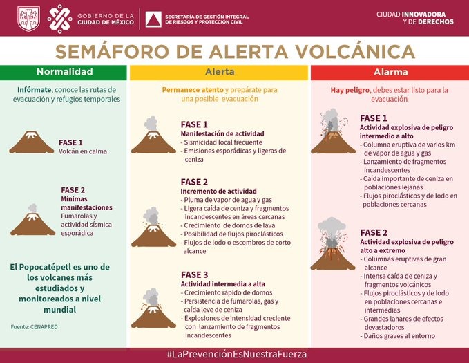
Status:
Yellow, Phase 3.
- Webcams de Mexico has live webcams, which are free but not embeddable
- Current CENAPRED report (Spanish).
- Hazard map (Spanish)
- Washington VAAC page.
- Puebla Civil Protection (Twitter)
- Mexico City Secretaría de Gestión Integral de Riesgos y PC (Twitter)
- GVP page.
Update, May 25, 2023, 10:44 a.m., Pacific: Good morning, Popocatépetl!
🌋 Actividad del #Popocatépetl
Derivado de un episodio de tremor de baja amplitud, mantiene una emisión continua de vapor de agua y gas con bajo contenido de ceniza, alcanzando una altura entre 400 y 600 m con dirección sur sureste.
🚦#AmarilloFase3
🚷Radio de exclusión 12 km pic.twitter.com/gL6HCxihMK— Coordinación Nacional de Protección Civil (@CNPC_MX) May 25, 2023
https://platform.twitter.com/widgets.js
Per Twitter translation: “Derived from a low-amplitude tremor episode, it maintains a continuous emission of water vapor and gas with low ash content, reaching a height between 400 and 600 m in a south-southeast direction.
🚦#AmarilloFase3
🚷 Radius of exclusion 12 km”
The graphics in CENAPRED bulletins put that in perspective. Here is today’s graphic of what they call “exhalations,” that is, a quantification of what the rest of us simply call an eruption:

That reflects how it has obviously calmed down recently from what this layperson called “high-end strombolian” activity a few days ago.
The tremor graphic shows a little bit of an inverse correlation to these untrained eyes:

Since tremor is caused by the movement of magmatic fluids; and fluids, mostly water vapor (judging by the white color), are definitely moving through the volcano and out the vent —
🌋🗻 Lanza enorme columna de ceniza, el volcán #Popocatépetl. Así se observa desde la autopista a #Atlixco. pic.twitter.com/t1KUETe0v9
— Carlos Martin Huerta (@carlosmartinh) May 25, 2023
https://platform.twitter.com/widgets.js
— my lay interpretation is that Popo is cooking right along.
Reportedly (autotranslated), starting today, the Mexican Navy is standing by at Amecameca, ready to launch some scientific drones at the first sign of clearing weather/visibility conditions up at the summit.
En conjunto con @SEMAR_mx, nos encontramos en Amecameca, para evaluar las condiciones actuales con el fin de realizar un sobrevuelo con dron y obtener imágenes del interior del cráter del #Popocatépetl 🌋 que permita conocer la dinámica y evolución de su actividad.@laualzua pic.twitter.com/WVYzq6nAq9
— Coordinación Nacional de Protección Civil (@CNPC_MX) May 25, 2023
https://platform.twitter.com/widgets.js
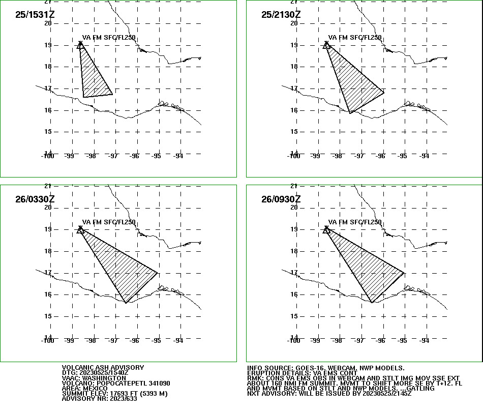
Otherwise, there is an ash advisory up, reporting ash emissions visible on cam and by satellites.
FVXX20 KNES 251540
VA ADVISORY
DTG: 20230525/1540Z
VAAC: WASHINGTON
VOLCANO: POPOCATEPETL 341090
PSN: N1901 W09837
AREA: MEXICO
SUMMIT ELEV: 17693 FT (5393 M)
ADVISORY NR: 2023/633
INFO SOURCE: GOES-16. WEBCAM. NWP MODELS.
ERUPTION DETAILS: VA EMS CONT
OBS VA DTG: 25/1531Z
OBS VA CLD: SFC/FL250 N1901 W09840 – N1901 W09832
– N1644 W09708 – N1635 W09828 – N1901 W09840 MOV
SE 30KT
FCST VA CLD +6HR: 25/2130Z SFC/FL250 N1905 W09835
– N1649 W09558 – N1550 W09733 – N1859 W09840 –
N1905 W09835
FCST VA CLD +12HR: 26/0330Z SFC/FL250 N1903
W09835 – N1701 W09504 – N1537 W09632 – N1858
W09840 – N1903 W09835
FCST VA CLD +18HR: 26/0930Z SFC/FL250 N1904
W09835 – N1700 W09504 – N1537 W09632 – N1859
W09840 – N1904 W09835
RMK: CONS VA EMS OBS IN WEBCAM AND STLT IMG MOV
SSE EXT ABOUT 160 NMI FM SUMMIT. MVMT TO SHIFT
MORE SE BY T+12. FL AND MVMT BASED ON STLT AND
NWP MODELS. …GATLING
NXT ADVISORY: WILL BE ISSUED BY 20230525/2145Z
Earlier posts:
Featured image Popocatépetl in early 2019, by Puebla Civil Protection (Spanish)
