
- Status: Orange, but —
El nivel de actividad naranja 🔶 del VNR nos indica que debemos estar preparados para una posible erupción de magnitud considerable. Como existe la probabilidad de que el volcán alcance el nivel de actividad rojo, este es el momento de tomar medidas de prevención⛑️ pic.twitter.com/jRoZPkXZEG
— Servicio Geológico Colombiano (@sgcol) May 1, 2023
https://platform.twitter.com/widgets.js
The take-away here: Ruiz might wind up steadily, if a major eruption is on its agenda, or it might just give them a few minutes’ notice before the “big one.”
- Interactive official hazard map (autotranslated), via Relief Web; En español
- USAID April 4th map (autotranslated) posted on May 18 at Relief Web.
- Links to webcams, public data, and other information.
- Update archive.
Update, May 20, 8:22 a.m., Pacific: A beautifully clear morning in the northern Andes, per this video from Tolima Civil Defense:
It is narrated by, I think, this Luis Fernando Vélez. According to the YouTube transcript, he briefly describes yesterday’s announcement of changes in the exclusion zone (autotranslated).
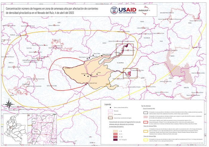
Of note, on May 18, Relief Web posted this April 4 USAID map (autotranslated) of the homes at high risk of pyroclastic flows.
Source (autotranslated).
The following is from today’s SGC bulletin (emphasis added by either SGC or me:
From 9:00 a.m. yesterday (May 19) until the time of publication of this bulletin, the seismic activity associated with rock fracturing inside the volcanic edifice maintained similar levels in the number of earthquakes and in the seismic energy released, compared to the previous day. (May 18). This seismicity was located mainly in the north-northwestern sector and, to a lesser extent, in the northeastern and southeastern sectors of the volcano, as well as in the Arenas crater, at a maximum distance of 8 km from it. The earthquakes presented low magnitudes and their depths ranged between 1 and 6 km.
Regarding the seismicity related to the movement of fluids inside the volcanic conduits, this activity maintained low levels in the number of earthquakes and in the seismic energy released, although it showed a slight increase compared to the previous day (May 18). Some of the seismic signals were associated with pulsatile ash emissions confirmed through the web cameras used for volcanic monitoring.
Additionally, variations continue in the degassing of sulfur dioxide and the release of water vapor from the crater into the atmosphere. The maximum height of the column of gases was 900 m, measured from the top of the volcano. The dispersion direction of the column was predominantly towards the southwest of the volcanic structure. Yesterday, it was not possible to observe the existing thermal anomaly at the bottom of the crater, due to the amount of gases and steam emitted by the volcano.
All these indicators ratify what the SGC has reiterated: the activity of the Nevado del Ruiz volcano continues to be highly unstable. It is possible that the levels of seismic activity, as well as the levels of degassing or ash output, decrease or be oscillating, in the sense of increasing on some days and decreasing on others. However, this does not imply that the volcano has returned to its normal levels of activity, so it is recommended not to get used to these oscillating changes in activity and think that it is a normal activity of the volcano.
Therefore, we reiterate that the activity of the Nevado del Ruiz volcano continues at ORANGE LEVEL, which indicates that there is a probability that in days or weeks it will erupt more than it has in the last 10 years. To change the level and return to the Yellow level, a prudential time is required where trends and patterns can be observed that allow us to infer the possible decrease in activity, aspects that the current activity of the volcano still does not show. For this reason, we warn that the level of activity of the Nevado del Ruiz volcano will remain at ORANGE LEVEL for several weeks. During this time, in the event of an acceleration of processes suggesting an imminent eruption or the eruption itself occurring, the activity level will be changed to Red.
We recommend that the community remain calm, follow all the instructions of the National Unit for Disaster Risk Management (UNGRD) and local authorities, and be attentive to the information provided by the Colombian Geological Service on the evolution of the state of the volcano.
The level of activity of the volcano remains at ORANGE LEVEL of activity or (II): PROBABLE ERUPTION IN TERMS OF DAYS OR WEEKS.
The COLOMBIAN GEOLOGICAL SERVICE will continue to be attentive to the evolution of the volcanic phenomenon and will inform opportunely about the changes that may occur.
For more information visit the following link:
https://www2.sgc.gov.co/Noticias/boletinesDocumentos/Forms/AllItems.aspx
No VAAC ash advisory is in effect for Ruiz right now. The last one goes back to the 15th of May.
Featured image: Ric Photography/Shutterstock
