
…for approving lahar detection systems this fall in two additional river drainage systems at the volcano, while still preserving the park’s wilderness integrity.
To see why that decision might help to save thousands of lives some day, let’s check out Mount Rainier, first in a video and then with the current draft of my revised Decade Volcano eBook chapter on it.
A note
By the way, you might have noticed that there are no interviews with the USGS and other knowledgeable sources in any of these Decade Volcano posts (or in the eBook). All this information is from papers and online available resources
I didn’t even think of it at first, but for the second edition I have made the conscious decision (and will mention it in the new introduction).
Why no interviews? Because I’m still in student mode, not doing active journalism. Otherwise, I never could have been so thorough. There are lots of disadvantages to such an approach, but (at least for a 60-something retired MT with a forestry AAS and two additional years in undergraduate geology under her belt — and probably in some other cases) there are advantages, too.
The main benefit all around is that I can look at a topic as big as Mauna Loa or Olympus Mons the way all of us laypeople do and then use what I know (bare minimum, really, and not always sufficient) to independently but reliably ask intelligent questions and report as accurately as possible.
Yes, “report.”
I will be doing journalism — someday fairly soon, hopefully, and probably at this blog in a separate category and/or page. But I still haven’t earned my wings for that yet. There are two chief barriers to overcome, still:
- Professional level: I still have to do a project before completing my Coursera journalism course and my personal situation is not quite supportive of that yet. I do have the project planned (it’s cat related, BTW), but a little more time is needed before I can do it.
- Personal level: I have a real case of hero worship with all geologists; guess it’s because they can do something I couldn’t, though giving it my best shot in the Eighties. And here in US volcano country — well!
We’ll see how it goes.
Anyway, here’s the present iteration of the Mount Rainier chapter; the last part is a very rough draft (see the writing update earlier this week).
Chapter 6: Mount Rainier (Washington State)
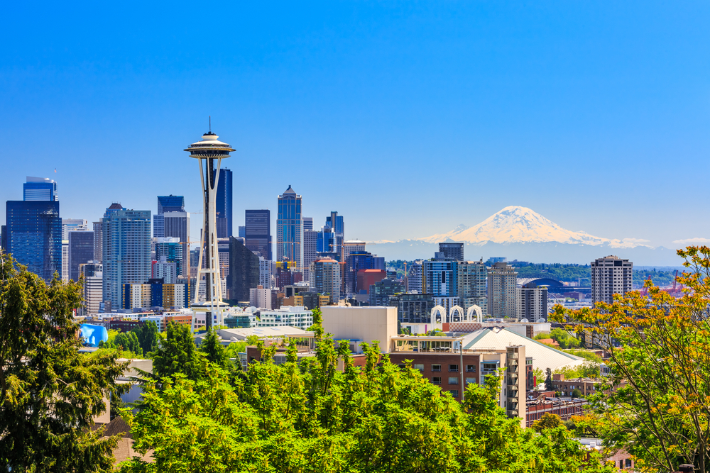
SCStock/Shutterstock
First things first: Does Rainier really tower over the city like that?
Photographers sometimes bring it closer with a telephoto lens for dramatic effect, but in real life as in the above image, Mount Rainier is indeed gigantic.
This active US volcano is well over 14,000 feet tall. The summit is heavily frosted with a cubic mile of glacial ice and permanent snow fields — about 30x the mass of frozen water that was on Mount St. Helens when it erupted in 1980. (CVO, 2022; Pierce County)
Rainier is the highest peak in the Cascade Range and it’s located only forty miles or so southeast of the Seattle-Tacoma metropolitan area.
That is much farther away than, say, Mount Vesuvius is from downtown Naples, but the main hazard here is different, too: Mount Rainier has a nasty habit of dropping down into the low country for a visit.
Literally.
Less than six millennia ago, some of the land that is now underneath Seattle and Tacoma was up on Mount Rainier’s slopes! Parts of southern Seattle also sit on material that has slid off the great volcano at other times. (PNSN; Vallance and Sisson)
Since the last ice age ended, Rainier has had more than fifty such landslides, which are also called lahars or mudflows. (Vallance and Sisson)
These lahars are on a much bigger scale than Mount Rainier’s typical debris flows and rock avalanches; those small, chaotic jumbles of stone and muddy water occur every year and, per Wallace et al., usually stay within Mount Rainier National Park.
This 2019 debris flow was caused by meltwater coming out from under a glacier. Storms and heavy rainfall cause debris flows, too. Farther down in the post are some nighttime shots of a Rainier-style lahar that happened at a Colombian volcano in 2008 — it’s quite bigger and more powerful than a debris flow. Of note, some of the new detection equipment reportedly also can help monitor debris flows in Tahoma Creek.
Only a few lahars were massive enough to travel all the way down river valleys to the Puget Sound lowlands where millions of people now live, work, and play. (NPS; Pierce County; Vallance and Sisson)
But all it takes is one.
During the second half of the twentieth century, volcanologists realized that big lahars from Mount Rainier are the major volcanic hazard to population centers here, rather than huge explosions (although Rainier also has had some plinian and subplinian blasts over its long history, eruption products tend to stay on or near the volcano, and prevailing winds would take the plume eastward — away from the local urban and suburban centers). (Pierce County; Vallance and Sisson)
Another concern as the International Decade dawned was that, thanks to an economic boom, hundreds of thousands of people were moving into new developments located in the Puyallup and some other river valleys that run down from the iconic volcano toward Puget Sound and its coastal lowlands.
A view of Mount Rainier, which dominates that landscape, definitely adds to a property’s value.
But in the early 1990s, most of the people who enjoyed the close-up sight of all those mountain glaciers and snow up there, twinkling in sunlight under a deep blue sky, didn’t know that their land was conveniently broad and flat for suburban development only because mudflows from Mount Rainier had buried whole forests and other landscape features here as recently as five centuries earlier: “this morning,” in geologic terms.
What has happened in the past can happen again.
With so much at stake downstream of the famous but dangerous giant, scientists selected Mount Rainier for further study, as well as public outreach, through the Decade Volcano program. (Newhall; Vallance and Sisson)
What is Mount Rainer?
It is a stratovolcano, like Vesuvius, Santorini, and many other tall, pointy volcanoes around the world.
While many exceptions exist, shield volcanoes tend to form in rift settings or, as Mauna Loa has done, at hotspots. Stratovolcanoes, on the other hand, are typically found in subduction zones. (Encyclopedia Brittanica)
Along with St. Helens, Hood, and other fire mountains of the Pacific Northwest (Harris), Mount Rainier conducts its business in the Cascadia subduction zone, some 50 to 100 miles or so east of the Pacific seafloor trench where tectonic oceanic microplates are subducting underneath the leading edge of the North American continent.
This subduction has been going on for a long time and has built all Cascade volcanoes, past and present. (Klemetti, 2015)
In one form or another, the structure that we know as Mount Rainier — Native Americans named it something along the lines of “Tacoma” or “Tahoma” — has been here for the last 500,000 years. Volcanologists also have found traces of its daddy, “Ancestral Rainier,” active 1 to 2 million years ago, atop even older igneous rock. (CVO, 2022; Vallance and Sisson)
Rainier’s hazards
As a subduction zone stratovolcano, Mount Rainier is explosive. It has gone off about twelve times over the last 2,600 years. The geological record is not easy to read here, but eruptions with an assigned intensity were usually, at most, VEI 2 or VEI 3. (GVP; Vallance and Sisson)
For perspective, the big 1980 eruption of nearby Mount St. Helens was VEI 5, while its much quieter 2004 activity — which many people now could follow online and, from my own experience, did because of that volcano’s fame — was a VEI 2.
The largest eruption given for Mount Rainier, among those listed with an intensity rating at the Global Volcanism Program website, was at most VEI 4. It occurred around 250 BC.
Vallance and Sisson report that Rainier tends to have centuries-long clusters of eruptions separated by quiet spells that can last as long as 2,000 years.
Lava last flowed here some 2,200 years ago. The most recent known pyroclastic flow from Mount Rainier was about 1,100 years ago, and its last confirmed eruption was in 1450 AD. There are some 19th-century newspaper and other reports of eruptions, but field work hasn’t uncovered any evidence to support those claims yet. (CVO, 2022a; GVP; Vallance and Sisson)
Next time, whenever that comes — Mount Rainier is asleep at the time of writing — ashfall, ballistics, pyroclastic flows, ground movements, and/or lava are likely to cause problems for people close to the volcano; plume fallout also will be a hazard to the east because of prevailing winds — in Seattle or Tacoma, not so much, unless the wind is blowing westward; even then, those cities probably would only get an inch of ash, or less. (Bernhard; CVO, 2022a; Pierce County; Vallance and Sisson)
The main threat from Mount Rainier for everyone in the lowlands, particularly west of the volcano, is one of those big landslides.
Smaller lahars happen much more often, but a big one could come from either a rare collapse or, more commonly, from interactions between magma/hot rocky materials and water (frozen or liquid, Mount Rainier has a lot of that!) associated with an eruption. (CVO, 2022a, 2022b; Vallance and Sisson)
This famous scene happened at Mount St. Helens in 1980, when hot volcanic material melted that volcano’s flaciers and permanent snow:
Remember: Mount Rainier has thirty times as much ice mass on it as St. Helens did when it erupted.
Here is a video the USGS posted a few months ago about the lahar danger at Mount Rainier. I think the term for what they are modeling is “flank collapse.”
There is also such a thing as “sector collapse” — flank+summit, as at Mount St. Helens on May 18, 1980.
We’ll get into what the Electron and Osceola flows were later in this post.
Material carried down in big lahars of each type — from either glacial melt during eruptions or from landslides — underlies parts of Seattle. (Vallance and Sisson)
Why do volcanoes collapse?
There might be contributing factors, like the combination of internal pressure from rising magma and a large earthquake that led to the enormous landslide (and sideways blast) at Mount St. Helens on May 18, 1980.
Sometimes a volcano just falls down, either during an eruption or — scary thought — without warning during a quiet spell.
It can happen at any fire mountain, but some researchers have found the highest number of collapses at subduction-zone stratovolcanoes and certain types of intraplate volcano. (Romero et al.)
At Teide’s Las Cañadas caldera (possibly) and at some other volcanoes in the Canary Islands and elsewhere, this can happen gradually as large blocks of rock giving way. It’s serious but not always immediately catastrophic; in fact, it is ongoing at another intraplate volcano — Fogo, in the Cape Verde Islands — and you might not even have been aware of that fact until now.
In the Cascadia subduction zone, at Mount Rainier, what happens is that water gets inside the volcano’s walls from a variety of sources, including precipitation and glacier melt. There, it’s heated by magma (Rainier has been sleeping for centuries but is still active).
This hot, sulfur-rich water then circulates through the wall rock, enabling chemical reactions that, over geologic time, turn stone into clay — a material that cannot support a mountain’s weight for long, especially one that carries so many heavy glaciers.
The hydrothermally altered rock eventually collapses, and what used to be a mountainside immediately surges down river drainages.
When the volcano’s flank fails, landslide material includes not only rock blocks but also enough clay and extra water from aquifers, ice, and snow mixed in to turn the huge muddy mess into something that gravity can act on as if it were a single unit (Vallance and Scott) — not a good thing to have coming at you from such high, steep terrain.
A major mudflow travels far. It isn’t spectacular, like an eruption, but it is twice as mobile as a debris flow and can spread out over an incredibly large area (Vallance and Scott), for example, down a river drainage all the way to Tacoma and Seattle, as the Osceola Mudflow did about 5,600 years ago: “last night,” in geologic terms.
The Osceola flow was associated with an eruption (Vallance and Sisson), which is something that would have drawn everyone’s attention before the lahar and already have them thinking about what to do in an emergency that could come at any moment. This is good.
However, the geologic record shows that, while many of Rainier’s huge lahars were associated with eruptions, many were not. (Vallance and Sisson)
That means the mountain could collapse without showing any signs of trouble. This is bad, obviously.
In fact, that’s how the last big lahar at Mount Rainier — the Electron Mudflow — might have started, about 500 years ago.
The Electron Mudflow: Flank Collapse
In the 1500s, material covering what are now the beautiful cliffs of Mount Rainier’s Sunset Ampitheater slid away into the river valleys below. This wall of volcanic mud, rocks, and debris was still almost 100 feet high when it reached the Puget Sound lowland, 60 miles away, near what is now the town of Electron, Washington. (CVO, 2022b; Lockhart; USGS)
If news crews had been around back then, it might have looked something like this video from 2008, showing what Lockhart has described as a lahar similar in size to the Electron flow.
The report is in Spanish, since this happened in Colombia at Nevado del Huila volcano.
Fortunately, early warning gave people near Nevado Del Huila time to evacuate safely. This mudflow occurred at night, but there still is amazing footage of it in motion, particularly at around the 1:08 mark.
Unlike other major Rainier lahars, the Electron Mudflow can’t be correlated with an eruption.
No one knows for sure what set it off, and volcanologists note that it “reminds us of the possibility that, occasionally, lahars may have non-eruption origins and thus may occur with little conventional warning.” (CVO, 2022b, including quote; Vallance and Sisson)
A lahar without warning is what Pierce County refers to in its emergency plan as a worst-case scenario — unlikely but destructive and deadly.
Suddenly or with precursors, the Electron lahar was not Rainier’s biggest.
The Osceola Mudflow: Sector Collapse
The biggest known landslide at Mount Rainier occurred some 5,600 years ago.
Called the Osceola Mudflow, it happened during an eruption and took off the volcano’s upper 1 km (a little over half a mile), as well as its northeast flank, and then sped down the White River drainage at 40-50 mph — rolling over at least one Native American settlement along the way. (Stanstreet et al.)
Eventually it slowed and spread out in the Puget Sound lowlands to form land that now underlies the ports of Tacoma and Seattle. (Driedger and Scott; John et al.; Sisson and Vallance)
The Osceola sector collapse and its accompanying lateral blast left a mile-wide Mount St. Helens-style crater that subsequent lava flows have filled in, building today’s frosted summit cone. (John et al.; Pierce County)
Is that about to collapse?
Probably not any time soon, per Vallance and Sisson. They note that the Osceola Mudflow cleared most hydrothermally altered rock from Rainier’s former summit and upper east flank.
According to them, later eruptions filled in the Osceola crater so thoroughly that, even though there are fumaroles and other signs of hydrothermal activity up there, it will take a lot more time to turn that new rock into clay and cause another sector collapse.
That’s good news.
But, the two boffins add, a lot of the rock in Mount Rainier’s western upper flank — the one overlooking all those millions of residents and visitors in the low country — is weak.
That is not good — but it always helps to be aware of a hazard before trouble starts.
This in-depth awareness of Mount Rainier’s structural hazards has grown out of work done during the International Decade.
Mount Rainier and the Decade Volcano Program
Awareness of the lahar threat at Mount Rainier first began to grow in the 1970s.
Then came the 1980 eruption of nearby Mount St. Helens, which focused attention on volcanic hazards and the importance of volcano monitoring.
Another wake-up call was the lahar tragedy at Nevado del Ruiz Volcano in 1985, where more than 20,000 Colombians perished.
The first hazard map for Mount Rainier came out in 1995 and today, thanks to this program and ongoing work since then, there are lahar detection systems in place as well as county emergency plans (PDF), warning sirens, and other measures in place, especially at the local level, to save lives.
Stats
Location:
46.853° N, 121.76° W, in Pierce County, Washington, US. The GVP Volcano Number is 321030.
Nearby Population:
Per the Global Volcanism Program website, not counting the 2 million people drawn to Mount Rainier National Park or the 1.5 million who attend the Western Washington Fair in Puyallup (one of the towns most vulnerable for a lahar) each year:
- Within 5 km (3 miles): 0.
- Within 10 km (6 miles): 128.
- Within 30 km (19 miles): 3,187.
- Within 100 km (62 miles): 2,667,609.
Current Status:
Normal, Aviation Code Green.
Eruptions:
Mount Rainier is a big pile of lava flows, unlike Mount St. Helens, which has somewhat “stickier” magma and tends to build up lava domes.
Rainier tends to cycle through clusters of eruptions, with centuries to millennia of dormancy or low-level single eruptions in between. It is in one such quiet period now.
While Rainier did have a subplinian blast some 2,200 years ago, most of its eruptions during these active cycles are moderate in size. Some of the small ones leave nothing more than a thin layer of fine ash for volcanologists to puzzle over.
Biggest recorded event:
A VEI 4 eruption about 2,200 years ago, coming near the end of a 400-year-long bout of activity called the Summerland eruptive episode.
Most recent eruption:
People in Seattle reportedly witnessed some sort of activity on Rainier in 1894, but the last confirmed eruption listed by the Global Volcanism Program happened in 1450.
While the timing of roughly 500 years ago works, field work by Sisson and Vallance didn’t uncover any clear connection between the 1450 eruption and the Electron Mudflow.
This raises the unsettling possibility that the volcano can collapse suddenly, without warning.
Past history:
See the GVP for details.
Mount Rainier hasn’t been all that active during recorded history, which only goes back to the early 1800s. Some Native American oral histories mention the volcano, but it isn’t easy to link the stories to geological events.
There has been a volcano of one sort or another at this location for at least two million years. What we call Mount Rainier first appeared about 500,000 years ago and grew in spurts, with periods of frequent lava flows followed by much quieter spells interrupted now and then by a single eruption. (John et al.)
The last eruptive period — called Fryingpan Creek — was from 1,100 to 1,000 years ago. Since then, Rainier has had just a few modest belches.
Monitoring:
The Cascades Volcano Observatory and Pacific Northwest Seismic Network (PNSN).
Here are some webcams.
The Washington Volcanic Ash Advisory Center (VAAC) will issue advisories when Mount Rainier erupts again.
Featured image: Lorie Brownell/Shutterstock
Sources:
- Bernhard, J. 2019. How a Mount Rainier eruption could impact Seattle vs. the South Sound. https://www.king5.com/amp/article/news/local/disaster/how-a-mount-rainier-eruption-could-impact-seattle-vs-the-south-sound/281-aed7af0a-3e7f-4eb7-bfde-07c22ceffb2d Last accessed November 2022.
- Cadag, J. R.; Driedger, C.; Garcia, C.; Duncan, M.; and others. 2017. Fostering participation of local actors in volcanic disaster risk reduction, in Observing the Volcano World, Fearnley, C. F.; Bird, D. K.; Haynes, K.; McGuire, W. J.; and Jolly, G., eds, 481-497. Springer: Cham, Switzerland.
- Cartier, K. M. S. 2020. U.S. readies health response for the next big eruption, Eos, 101, https://eos.org/features/u-s-readies-health-response-for-the-next-big-eruption Last accessed July 21, 2020.
- Cascade Volcano Observatory (CVO). 2022. Mount Rainier. https://www.usgs.gov/volcanoes/mount-rainier Last accessed November 2022.
- ___. 2022a. Volcanic hazards at Mount Rainier.
https://www.usgs.gov/volcanoes/mount-rainier/volcanic-hazards-mount-rainier Last accessed November 2022. - ___. 2022b. Mount Rainier: Geology and history. https://www.usgs.gov/volcanoes/mount-rainier/geology-and-history-summary-mount-rainier Last accessed November 2022.
- ___. 2022c. Significant lahars at Mount Rainier. https://www.usgs.gov/volcanoes/mount-rainier/significant-lahars-mount-rainier Last accessed November 2022.
- Driedger, C., and Scott, W. E. 2008. Mount Rainier—Living Safely with a Volcano in Your Backyard. U.S. Geological Survey Fact Sheet , 2008-3062, 4 p. http://pubs.er.usgs.gov/publication/fs20083062
- Driedger, C.; Calvache, M.; Cortés, G. P.; Ewert, J.; and others. 2020. Leveraging lessons learned to prevent future disasters—insights from the 2013 Colombia-US binational exchange. Journal of Applied Volcanology, 9(1): 1-21.
- Global Volcanism Program (GVP). 2022. Mount Rainier. https://volcano.si.edu/volcano.cfm?vn=321030&vtab=GeneralInfo Last accessed November 2022.
- Encyclopedia Britannica. n.d. Volcanoes related to plate boundaries. https://www.britannica.com/science/volcano/Volcanoes-related-to-plate-boundaries Last accessed November 26, 2022.
- Harris, S. L. 2005. Fire Mountains of the West: The Cascades and Mono Lake Volcanoes. Mountain Press.
- Hoblitt, R. P.; J.S. Walder, J. S.; Driedger, C. L.; Scott, K. M.; and others. 1998. Volcano hazards from Mount Rainier, Washington, revised 1998 (p. 11). US Department of the Interior, US Geological Survey Open-File Report 98–428.
- John, D. A.; Sisson, T. W.; Breit, G. N.; Rye, R. O.; and Vallance, J. W. 2008. Characteristics, extent and origin of hydrothermal alteration at Mount Rainier Volcano, Cascades Arc, USA: Implications for debris-flow hazards and mineral deposits. Journal of Volcanology and Geothermal Research, 175(3): 289-314.
- KING-TV. 2019. Hazards at Rainier. https://youtu.be/GjIwiiuD_QI
- Klemetti, E. 2020. The 40th anniversary of the Mount St. Helens eruptions reminds us the Cascades are still dangerous. https://www.discovermagazine.com/planet-earth/the-40th-anniversary-of-the-mount-st-helens-eruptions-reminds-us-the Last accessed July 24, 2020.
- ___. 2015. Why have volcanoes in the Cascades been so quiet recently? https://www.discovermagazine.com/the-sciences/why-have-volcanoes-in-the-cascades-been-so-quiet-lately Last accessed November 26, 2022.
- Lee, J. 2017. Mount Rainier to get new digital-warning system for massive mudflows. https://www.seattletimes.com/seattle-news/environment/mount-rainier-to-get-new-digital-warning-system-for-massive-mudflows/ Last accessed July 21, 2020.
- Lockhart, A. 2020. Lahar detection system developments at Mount Rainier, USGS presentation. https://youtu.be/jO5YPpTeth8
- National Park Service. 2020. Mount Rainier: Geohazards. https://www.nps.gov/mora/planyourvisit/geohazards.htm Last accessed November 2022.
- Newhall, C. 1996. IAVCEI/International Council of Scientific Union’s Decade Volcano projects: Reducing volcanic disaster. status report. US Geological Survey, Washington, DC. Retrieved from https://web.archive.org/web/20041115133227/http://www.iavcei.org/decade.htm
- Oregon State University (OSU). 2020. Rainier. http://volcano.oregonstate.edu/rainier Last accessed July 21, 2020.
- Pierce County. 2008. Mount Rainier Volcanic Hazards Plan. (PDF download)
- Pinsker, L. 2004. Paths of Destruction: The Hidden Threat at Mount Rainier. http://www.geotimes.org/apr04/feature_MountRainier.html Last accessed December 20, 2020.
- PNSN (Pacific Northwest Seismic Network). 2020. Mount Rainier. https://pnsn.org/volcanoes/mount-rainier#description Last accessed December 21, 2020.
- Romero, J. E.; Polacci, M.; Watt, S.; Kitamura, S.; and others. 2021. Volcanic lateral collapse processes in mafic arc edifices: A review of their driving processes, types and consequences. Frontiers in Earth Science, 9: 639825.
- Sisson, T. W., and Vallance, J. W. 2009. Frequent eruptions of Mount Rainier over the last∼ 2,600 years. Bulletin of Volcanology, 71(6): 595-618.
- Stanistreet, I. G.; Stollhofen, H.; Njau, J. K.; Farrugia, P.; and others. 2018. Lahar inundated, modified, and preserved 1.88 Ma early hominin (OH24 and OH56) Olduvai DK site. Journal of Human Evolution, 116: 27-42.
- Swanson, D. A.; Cameron, K. A.; Evarts, R.; Pringle, P. T.; and Vance, J. 1989. Cenozoic Volcanism in the Cascade Range and Columbia Plateau, Southern Washington and Northernmost Oregon. AGU Field Trip Guidebook , T106, 60 p. doi:ISBN: 0-87590-604-4
- Thelen, W. A.; Allstadt, K.; Kramer, R.; Lockett, C.; and others. 2019. Current Status of the Mount Rainier (Washington) Lahar Detection System. AGUFM, 2019, V51K-0254. (Abstract only)
- Vallance, J. W., and Scott, K. M. 1997. The Osceola Mudflow from Mount Rainier: Sedimentology and hazard implications of a huge clay-rich debris flow. Geological Society of America Bulletin, 109(2): 143-163.
- Vallance, J. W., and Sisson, T. W. 2022. Geologic field-trip guide to volcanism and its interaction with snow and ice at Mount Rainier, Washington. U. S. Geological Survey Scientific Investigations Report 2017-5022-A, 76 p.
- Vallance, J. W.; Cunico, M. L.; and Schilling, S. P. 2004. Debris-flow hazards caused by hydrologic events at Mount Rainier, Washington. US Department of the Interior, US Geological Survey. https://pubs.er.usgs.gov/publication/ofr03368
- Wenzelburger, J. 2022. Mount Rainier National Park approves expanded lahar detection system. https://www.chronline.com/stories/mount-rainier-national-park-approves-expanded-lahar-detection-system,287553 Last accessed November 2022.
- Wikipedia. 2020. Mount Rainier. https://en.m.wikipedia.org/wiki/Mount_Rainier Last accessed July 21, 2020.
Last accessed in 2020.
🌋
