
No, I haven’t mixed up the photos. That is Mount Rainier in Washington State, not central Colombia’s Nevado del Ruiz volcano. For reasons that will become clear later in the post, Colombians find this majestic sight very disturbing, and Washingtonians know why.
But first, have you ever noticed that volcanologists seem like an awfully anxious bunch?
They’re always nagging us in videos, websites, articles, and public talks about lahars — volcanic mudflows — and other potential disasters.
Since a volcano usually goes decades to centuries in between eruptions, we forget the danger and tend to ignore or dismiss such talk as alarmist. But it can have economic results, as some California communities found out in the 1980s.
The movie Dante’s Peak — whose hero, by the way, is an anxious volcanologist named Harry Dalton — presents a thinly disguised version of the real events during this scene:
This character, who is Harry’s boss, is actually likable elsewhere in the movie but (spoiler) he dies in a lahar during a thinly disguised recreation of the 1980 Mount St. Helens eruption.
Why are earth scientists always hollering about volcanic hazards?
Because they know what volcanoes can do, even those that don’t act up very often.
The rest of us hardly ever think about such things until one explodes near us. Then we’re too frightened to think about anything except escape.
Time out for an eruption video.
This Chilean volcano had slept 9,000 years and gave just one day’s notice before going plinian!
Before 1985, volcanologists didn’t talk to the public very much about their work. After the publicity and excitement of an eruption had died down, the subject bored everyone except nerds.
If they did spot trouble looming — a big “if” during most of the twentieth century, given technology limitations and the remoteness of many volcanoes — experts notified the appropriate civil and military authorities, who decided what to do about it.
Then tragedy struck at Armero, Colombia, on November 13, 1985. (More than a thousand lives were lost in two other towns that night; the sheer scale of the disaster in Armero is what gives this event its name.)
That is when volcanologists realized “that science is not enough, it needs to be effectively communicated and understood.” (Fearnley et al.)
They haven’t stopped talking about volcanic hazards ever since, and they never will. It was a costly, unforgettable lesson.
Mauricio Morales via Wikimedia, CC BY-SA 4.0.
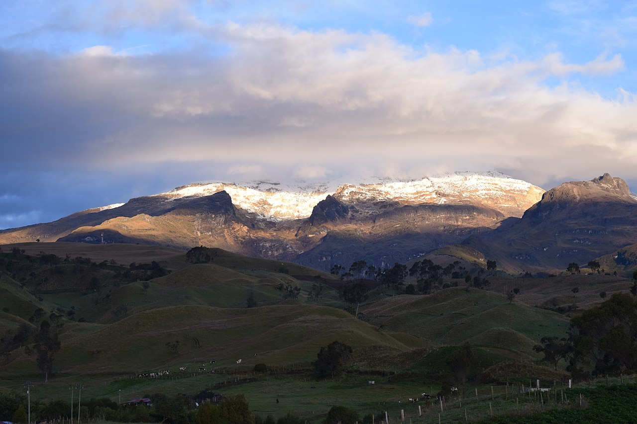
The Volcano
Nevado means “snow-capped.”
This equatorial Andean stratovolcano, like many others in the region, is tall enough to sport vast snow fields and summit glaciers.
There’s room up there for all that frozen water. Nevado del Ruiz is a gorgeous, icy behemoth covering almost 80 square miles of land in two central Colombian departments.
It is built out of three ancient volcanoes, the oldest of which first went into business about 1-1/2 million years ago.
Today, the volcano’s active cone sits in one of the earlier calderas, and modern eruptions — including the ongoing 2021 action — come through Arenas Crater at this cone’s summit.
Volcanologists suspect but thus far haven’t been able to prove that a smaller flank vent also may have had some activity since the last ice age ended. (Global Volcanism Program)

Radar image of Nevado del Ruiz, showing the many river drainages off the summit. Armero is off screen to the right, ENE of the volcano. (Image: NASA, via Wikimedia)
- Location: 4.892° N, 75.324° W, on the border between Tolima and Caldas Departments, Colombia. The Global Volcanism Program Volcano Number is 351020.
- Height: 17, 320 feet above sea level.
- Eruption styles: Nevado del Ruiz is a subduction-zone volcano, so its eruptions tend to be explosive, generally in the VEI 1 to 3 range. There’s power to a VEI 3 eruption, but in 1985 that hadn’t happened for 140 years. Locals therefore called this scenic landmark towering over their fields “The Sleeping Lion.” (Spanish-language Wikipedia)
They had forgotten the great mudflow that accompanied the 1845 eruption and killed fifteen people. (Brown et al)
As often happens at Nevado del Ruiz and other glaciated volcanoes, the 1845 eruption’s heat melted some of the summit ice and caused a lahar that grew in size, sweeping everything away as it dropped three vertical miles down river drainages before reaching the valley, spreading out, and finally coming to a stop.
At some point after this cement-like slurry had hardened, people built the settlement of San Lorenzo on it and in 1930 changed the town’s name to Armero in honor of a national hero, Jose Leon Armero.
In 1986, Pope John Paul II would declare (NOTE: Link is in Spanish and has disturbing images) the place, now abandoned by the living, a campo santo: “holy field.”
- Biggest recorded event: There are some VEI 4 blasts in Nevado del Ruiz’s early history. The last one occurred in 1595. It, too, caused lahars. These traveled the same routes as more recent ones did but were probably larger, since 636 people died in them, per Brown et al., although far fewer people lived near the volcano back then, compared to the 1800s.
And today?
According to sources quoted by Spanish-language Wikipedia, roughly half a million people live in hazard zones around Nevado del Ruiz, 100,000 of them in high-risk areas.
And the volcano just keeps doing its thing, over and over again. But now it is closely monitored.
- La Violencia, Colombia’s long-standing (and, in 2021, ongoing) internal armed conflict and accompanying social ills, including political polarization, intimidation, and corruption; drug trafficking; terrorism; and interference by outside stakeholders.
- The Mexico City earthquake on September 19th, a little over a week after Ruiz, down in Colombia, had its first ash emission. Response to this national disaster limited the amount of aid that Mexico could send.
- December 1984: Nevado del Ruiz had been dozing since a very small eruption in 1916. Its last big one was back in 1845. People now began noticing some earthquakes up near the summit.
- March/April, 1985: No seismographs operated in the region, but 17 quakes were felt in March and 18 in April. Observers noted increased fumarole activity when they climbed up to Ruiz’s summit, but the one hot spring that was monitored showed no change.
- Over the summer, increased seismic and thermal activity continued. Observers found a small acidic lake at the summit and some unusual thawing of the ice up there. On July 23rd, the fumaroles became larger, releasing a huge yellow vapor cloud.
- September 11, 1985: The first ash emission started around 1 p.m. and continued for seven hours, but analysis showed that this was old material, not fresh magma. Still, it was a forceful blast, tossing big blocks as much as a mile and dusting cities up to 19 miles away. A lahar also formed, almost 70 feet thick at spots. It traveled 17 miles down the Rio Azufrado and people in the valley were put on alert, though no evacuation was needed. Scientists at this time were making a hazard map for distribution to Red Cross and civil defense authorities.

I think this is a more recent version of that map. (Wikimedia (Spanish)
- September 13, 1985: Overflights and ground visits to the crater showed new fissures on some glaciers and a small pond atop the ice.
- October: Visits to the summit early in the month (don’t forget that these people were climbing a 17,300-foot-high volcano over and over!) found slightly weaker fumaroles, unchanged glaciers, and very little ash in the lazy white plume issuing from Arenas Crater. Seismographs had been deployed and were picking up 5-10 small quakes a day.
On October 22, per Spanish Wikipedia, scientists told authorities that Armero and other places were at high risk of a lahar and they suggested simple preventive measures. Sources quoted in this article report that the hazard map encountered “strong opposition from economic interests.”
Per San Diego University, INGEOMINAS told authorities that a moderate eruption at Ruiz would certainly cause mudflows and that Armero (east of the volcano), Ambalema, and the lower parts of Chinchina (to the west) were in great danger. This was reportedly dismissed by some officials as alarmist, while others did not see a need to evacuate those people. (Hindsight is 20/20 but let’s not rush to judgment too quickly — guerrillas had just bombed the Palace of Justice in Bogota, tying up government authorities and the military; it also was no simple thing, evacuating tens of thousands out in the country, at night, in bad weather, and to where? I’m curious about that “economic interests” remark, though, as well as the fact that FARC, one of the guerrilla groups, was founded in Tolima, per Karl. Even though it was far from Armero, might this have influenced some decision-makers in those highly charged days?)
In late October, eleven days of data from newly installed tiltmeters showed what appeared to be deflation (volcanoes about to erupt generally inflate a bit first).
- November 7, 1985: Seismicity began to increase at the volcano, though there were fewer quakes than before the event in September.
- November 10, 1985: Instruments picked up harmonic tremor — a sign of magma on the move — but it was weaker than that seen before the earlier blast on September 11th.
- November 12, 1985: Per San Diego University, observers visited the crater and saw no signs of imminent danger.
- November 13, 1985:
3:45 p.m. (all times here are approximate): Fresh magma reaches the surface at Ruiz, erupting during rainy weather. Ash falls as far as 37 miles away. The local Civil Defense leader calls INGEOMINAS and is told to take it up with Civil Defense at the departmental and federal level.
5:30 p.m.: In Armero, 29 miles from the summit, ash and small stones start falling. Emergency meetings are called; the details are unclear to me. Per San Diego University, the mayor and the local priest reassure townsfolk. The Red Cross wants an evacuation but calls it off after ashfall stops around 7 p.m.
A little after 9 p.m.: An observer 6 miles from the summit hears the first of a series of loud explosions, much louder than those of September 11, but weather hides the volcano. The heat released by this VEI 3 eruption melts an estimated 5% of the summit ice cap, and lahars start traveling down eleven river drainages, taking down power and telephone lines along the way. The first of these mudflows travels west along the Claro River, wiping out three bridges along the way, and floods low-lying parts of Chinchina, destroying 200 homes and killing about a thousand people.
10 p.m.: Ashfall is reported at Armero. A cargo plane flies into the eruption cloud; its windows are scratched by ash and the pilot finally lands safely, after two failed attempts, by sticking his head out of a side window.
The lahars coming down Rio Lagunillas and Rio Azufrado combine north of Armero, having picked up some extra water in a small lake behind a debris dam on the Lagunillas.
By now, Civil Defense officials outside the area are aware of the situation, per Spanish Wikipedia, but can’t get through to Armero: all lines are out.
11:30 p.m.: The first of three lahar waves, almost a hundred feet high, hits Armero.
Monitoring: Little to none before Ruiz awakened with summit seismicity in late 1984. Then, while residents near the volcano felt multiple earthquakes in March and April 1985, Colombia’s Institute of Geology and Mining (INGEOMINAS) requested and got seismometers and other equipment from several countries, including the US. (Augliere; Global Volcanism Program)
Affecting the efficiency of this transfer were two background complications:
The tragedy
I’m just going to outline this, using the Global Volcanism Program’s bulletins from 1985 mostly, and filling in with Augliere, San Diego University, and a little Wikipedia (English and Spanish). These sources are listed at the bottom of the post.
Also, here is an ArcGIS story map about the catastrophe. (You might get an error message but keep scrolling; it’s just a missing background image.)
Setting: About 29,000 people lived in Armero in 1984.
Volcanic soil is fertile and the wide valley around the town was well watered, with the Lagunillas and Azufrado rivers (their headwaters on Ruiz) joining up a few miles north of town.
As a result, Armero and its surrounding region thrived on agriculture. Most of Colombia’s cotton was grown here and about a fifth of the nation’s rice, as well as much coffee and sorghum.
Were there drug crops, too?
I couldn’t find online information earlier than 1990; since that news (Spanish) about cartels and poppy fields appeared as a breaking investigation and applied to all of Tolima Department (Armero and Ruiz are at the northern end, while guerrilla organizations developed in the south), perhaps this wasn’t very important in the early 1980s. But who knows?
Timeline: In brief, the scientists did everything right, and still almost everyone died.

Ruiz in September 1985, via Wikimedia, public domain.


Ruiz’s summit a couple weeks after the Armero disaster. (Image: J. Marso/USGS via Wikimedia)
The town and most of its residents were buried. Many of the injured died over next few days because no rescuer could get through the deep mud. Airlifts were of little help, since that cement-like material would not release entrapped victims.
Roads, bridges, farms, aqueducts, 50 schools, 2 hospitals, more than 5,000 homes, 60% of the region’s livestock, 30% of its rice and grain crops, half a million bags of coffee, and 24,000 men, women, and children — 80% of Armero’s residents — gone.
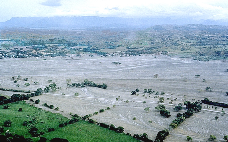
Armero, a couple weeks after the disaster. (Image: J. Marso/USGS via Wikimedia)
The aftermath
The election campaign was cancelled. The guerrillas called a temporary ceasefire. Help poured in from around the world. Recriminations bounced back and forth.
Survivors moved to other towns in Tolima, and the site where Armero was buried became consecrated ground.
Work began on a network that now makes Nevado del Ruiz one of the world’s most closely monitored volcanoes.
INGEOMINAS watches other fire mountains, too, and in 2007, they saw that Ruiz’s neighbor, Nevado del Huila, was waking up. They told authorities, who evacuated the town in greatest danger an hour before the arrival of Huila’s lahar, which was impressive although much smaller than what hit Armero in 1985.
The Tragedy of Armero is one reason why the United Nations declared the 1990s as a decade devoted to reducing global risk from a variety of natural hazards. This brought about the Decade Volcano program.
In addition, the US Geological Survey and US Agency for International Development formed VDAP — the Volcanic Disaster Assistance Program — in response to Armero.
The idea is to rapidly deploy technology and expertise to countries that lack full resources to deal with a dangerous volcano. VDAP has worked through more than thirty crises since then, most recently at La Soufriere St. Vincent, in the Caribbean, where local scientists and authorities moved up to 26,000 people out of harm’s way before that volcano blew.
Back in Colombia, healing continues in many ways. Survivors visit the field that once was their home and sometimes share their experiences with us.
Others served as extras in a German movie about Armero called Don’t Die.
And thirty-two years after the tragedy, Spanish-language film makers released Armero.
Life goes on. We have so much to be thankful for. But there is also much to learn and a need to be vigilant when there is an active volcano in the neighborhood.
So nag on, Harry Dalton & Company, nag on.
And thank you.
Featured image: E. Ruttledge/USGS
Sources:
Augliere, B. 2016. Benchmarks: November 13, 1985: Nevado del Ruiz eruption triggers deadly lahars. https://www.earthmagazine.org/article/benchmarks-november-13-1985-nevado-del-ruiz-eruption-triggers-deadly-lahars/ Last accessed May 10, 2021.
Brown, S.K.; Jenkins, S.F.; Sparks, R.S.J.; Odbert, H.; and Auker, M. R. 2017. Volcanic fatalities database: analysis of volcanic threat with distance and victim classification. Journal of Applied Volcanology, 6: 15.
Fearnley, C.; Winson, A. E. G.; Pallister, J.; and Tilling, R. 2018. Volcano crisis communication: challenges and solutions in the 21st century, in Observing the volcano world (pp. 3-21). Springer, Cham. https://link.springer.com/chapter/10.1007/11157_2017_28
Karl, R. A. 2018. La paz olvidada: políticos, letrados, campesino y el surgimiento de las FARC en la formación de la Colombia contemporánea. Libreria LERNER. PDF download: https://www.academia.edu/download/60987416/78228-427617-2-PB.pdf
San Diego University. n.d. How volcanoes work: The Nevado del Ruiz eruption. http://sci.sdsu.edu/how_volcanoes_work/Nevado.html Last accessed May 10, 2021.
US Geological Survey. 2021. Lahar. https://volcanoes.usgs.gov/vsc/glossary/lahar.html Last accessed May 10, 2021.
___. 2021. Lahars: The most threatening volcanic hazard in the Cascades.
https://www.usgs.gov/observatories/cascades-volcano-observatory/lahars-most-threatening-volcanic-hazard-cascades Last accessed May 10, 2021.
___. 2021. Lahars move rapidly down valleys like rivers of concrete. https://www.usgs.gov/natural-hazards/volcano-hazards/lahars-move-rapidly-down-valleys-rivers-concrete Last accessed May 10, 2021.
Wikipedia. 2021. Armero. https://en.wikipedia.org/wiki/Armero Last accessed May 10, 2021.
Wikipedia (Spanish). 2021. La tragedia de Armero. https://es.wikipedia.org/wiki/Tragedia_de_Armero Last accessed May 10, 2021.
