
December 22, 2022, 5:24 p.m., Pacific: In today’s update, HVO notes that there is no sign of inflation, and everything is cooling off.
Their Tuesday Kilauea update noted no activity, either. Guess Madam Pele has settled down for a nap — hope so, anyway!
December 14, 2022, 6:54 p.m., Pacific: Have been working offline most of the time on the DV book revision and only just now realized that yesterday HVO also reported that Kilauea has stopped erupting, too.
I’ve read of several times when the two were erupting at the same time but not ever that they stopped at the same time, too.
Hmm…
Is this a coincidence? Maybe. Maybe not. The volcanoes are not directly connected, but might "feel" one another via stress effects. Mauna Loa's eruption could have allowed Kīlauea to "relax." That said, Kīlauea's eruption was already pretty tenuous, occurring at very low rates.
— USGS Volcanoes🌋 (@USGSVolcanoes) December 13, 2022
https://platform.twitter.com/widgets.js
December 14, 12:36 p.m., Pacific: They called the eruption yesterday but only lowered the alert one notch, back to Advisory (Aviation Code down to Yellow).
The summit and Northeast Rift Zone (NERZ), they report, are still inflating, and they aren’t sure what that indicates.
As this layperson understands it, the inflation of so large an area probably means that magma is still coming in but there is no tremor detected, per the HVO update, to indicate that it is about to erupt.
GPS wasn’t available for the previous eruption (1984) and Mauna Loa’s size made leveling surveys unreliable back then.
So there are no data available to clue volcanologists in now on whether the giant always inflates after an eruption — atypical, as far as I know for volcanoes usually, but this is the world’s biggest active volcano and who knows what “typical” is for the “Long Mountain”?
It can do pretty much anything it wants, from trifling with us by means of a relatively small lava effusion (2022) to dropping the entire island’s south flank several yards (1868)!
More layperson speculation, for what it’s worth: I can think of three possibly relevant factors that might be complicating the situation:
- From my reading for the eBook entry, Mauna Loa usually goes about six years between eruptions, not 38. (I won’t get into whether 1984 was the usual, but delayed, rift-zone migration after the summit eruption that preceded it by about nine years or something else — I’m not sure if boffins have a consensus on that.)
- Its historical eruptions, as I understand it, usually are preceded by at least one M6-ish or stronger quake. This time, there were “just” a couple of M5-somethings in the Pahala area that they decided weren’t related to what was then an ongoing swarm up on the volcano.
I know, it seems picky, but an M6 is ten times as intense as an M5, so there is a considerable difference. And it points to this: this eruption either happened without a precursory big quake or those two M5-somethings were it, perhaps modified in some way by whatever is causing the longstanding Pahala swarm.
- Other volcanoes don’t have a Kilauea on their flanks. There is no consensus, as far as I have read, on whether Kilauea and Mauna Loa interact, and if so, how. I’m just pointing out a potential complicating factor for the recent and brief eruption.
Again, that’s just lay speculation, and so, not worth much.
The boffins are continuing daily updates through tomorrow and then, barring new developments, going to weekly updates on Thursdays.
I’ll keep this pinned until that first Thursday update.
December 11, 2022, 9:49 a.m., Pacific: Intellectually, I know that giant Mauna Loa can have very brief eruptions, but when lava starts to fountain, it’s only human to expect a long, big event.
Two days ago, though, the lava started tapering off, per HVO and views through the webcam; yesterday afternoon, the boffins lowered their alert level to Watch (the Aviation Code is still Orange), noting in their update:
High eruption rates will not resume based on past eruptive behavior and current behavior suggests that the eruption may end soon. However, an inflationary trend of Mauna Loa’s summit is accompanying the decreased activity and there is a small possibility that the eruption could continue at very low eruptive rates.
It isn’t often we get to see the planet’s biggest active volcano erupt, so I will leave this pinned for a while and see how things go.
December 7, 4:04 p.m., Pacific: No changes — just wanted to pass along the most recent Hawaii PODD information video, from last night, to keep things up to date.
Lava still hasn’t reached Saddle Road.
December 1, 2022, 10:12 a.m., Pacific: There isn’t any major change (though I got excited at what appeared to be lava up at the summit and turned out to be a lens effect from the early morning sun angle 😄 ).
This USGS tweet sums up things — it will continue to be fun for a couple days more, looks like; then the damage starts. 😿
See below the tweet[s] for links to HVO updates, etc., and earlier coverage; I’ll resume that format if the eruption changes from “typical” or if Hilo is threatened. This could end soon or it could go on for weeks, months, or (less likely), years.
Good morning #MaunaLoa! Lava flows continue down the northeast slope of the volcano. The flow front has hit a low-sloping spot and is beginning to spread out and inflate. You can get good views all day from the #HVO webcams. #MaunaLoaErupts https://t.co/y3pXoSdY3N pic.twitter.com/r2IImBbnmf
— USGS Volcanoes🌋 (@USGSVolcanoes) December 1, 2022
https://platform.twitter.com/widgets.js
Quick update, December 2, 8:32 a.m., Pacific: Tweeted about an hour ago — per preliminary results, no 1984 lava is found:
Geochemical results from first 48 hours of Mauna Loa eruption:
> glassy near vent
> small crystals of plagioclase and olivine at flow front as lava cools
> 6-6.8% MgO
> eruption temp 1156 C (2113 F)
> similar to past lava compositions
> no leftover lava from 1984 is apparent pic.twitter.com/35JOtnfL1X— USGS Volcanoes🌋 (@USGSVolcanoes) December 2, 2022
https://platform.twitter.com/widgets.js
- USGS webcams and eruption announcement.
- Updates from the Hawaiian Volcano Observatory.
- Mauna Loa chapter of my ongoing, as-yet unreleased Decade Volcano eBook revision.
- The 24-hour time-lapse from USGS cam on Mauna Kea, as of November 30, around 1530 UTC:
- Latest Two Pineapples live stream (November 30th):
- Star-Advertiser early coverage (I liked it; no commercial connection exists between them and this blog/me; their November 30th coverage is a premium):
November 29a.
November 29b. - Eruption start: From the USGS cam — 24 hour GIF saved at around 12:30 p.m., Hawaiian time:


November 30, 2022, 7:31 a.m., Pacific: At the moment, things seem to be developing as one would expect in a Northeast Rift eruption on Mauna Loa (after reading up on the 1984 eruption): lava erupting on the slope and oozing its way towards the sea in the general direction of Hilo:
- Here is an interview with scientists and officials, streamed about 13 hours ago:
The mayor, at one point is referencing this view (Kilauea on left, Mauna Loa on right):
Kīlauea and Mauna Loa erupt together. Photo from Kūpinaʻi Pali at 6:06 a.m. Monday in the park.
The park is open, but some closures are in place: https://t.co/uGEAjyqjH3
NPS Photo/J.Ibasan pic.twitter.com/fZ6bShiiZt
— Hawaii Volcanoes NPS (@Volcanoes_NPS) November 28, 2022
https://platform.twitter.com/widgets.js
- Here is the latest HVO update, issued around the same time:
The Northeast Rift Zone eruption of Mauna Loa continues, with several fissures and lava flows active. Several lava flows are traveling in a northeast direction. The longest and largest lava flow is issuing from fissure 3. This lava flow crossed the Mauna Loa Weather Observatory Road at approximately 8 p.m. yesterday evening, November 29, and the flow front was located approximately 4.5 miles (7.5 km) from Saddle Road at approximately 3:30 p.m. HST this afternoon (straight line distance).
This afternoon, fountains at fissure 3 were consistently 40-50 m (131-164 ft) tall and fountains at fissure 4, which formed at approximately 7:30 p.m. HST on November 28, were 5-10 m (16-33 ft) tall.
There is no active lava within Moku’āweoweo caldera, and there is no lava erupting from the Southwest Rift Zone. We do not expect any eruptive activity outside the Northeast Rift Zone. No property is at risk currently. There is a visible gas plume from the erupting fissure fountains and lava flows, with the plume primarily being blown to the North. Sulfur dioxide (SO2) emission rates of approximately 250,000 tonnes per day (t/d) were measured on November 28, 2022.
New webcam views of the Northeast Rift Zone of Mauna Loa are available at the links below:
https://www.usgs.gov/media/webcams/m5cam-mauna-loa-fissure-3-eruption-northeast-rift-zone
https://www.usgs.gov/media/webcams/m6cam-mauna-loa-northeast-rift-zone-uprift-view-wsw
https://www.usgs.gov/media/webcams/m4cam-mauna-loa-northeast-rift-zone-downrift-view-ene - And here is a simple map of the current eruption field that USGS Volcanoes tweeted about 15 hours ago. Of note, Ken Hon was quoted by the Star-Advertiser yesterday as saying that this flow would take a week to reach Hilo.
Overnight satellite views allowed USGS analysts to accurately map #MaunaLoa's active flows (solid red) with dotted lines marking additional downslope progression. Two fissures are active. Longest/largest flow is from fissure 3, headed NE ~5.5 miles from Saddle Rd. #MaunaLoaErupts pic.twitter.com/PhJh6pkxAS
— USGS Volcanoes🌋 (@USGSVolcanoes) November 30, 2022
https://platform.twitter.com/widgets.js
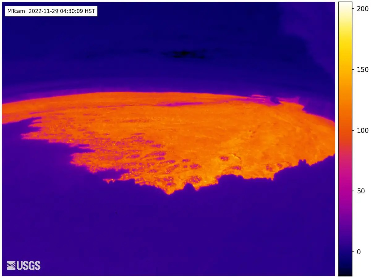
The only change this layperson has noticed is that the summit caldera flow field seems to be warming up.
On this GIF of thermal images over the last 24 hours up there, saved at 1633 UTC, yellows and oranges are hotter temperatures, and they start brightening when it’s well into the night, so it isn’t from solar heating:
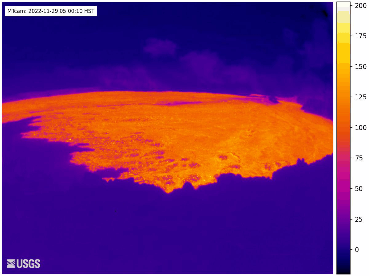
I think it’s probably from shallow lava feeding the NERZ eruption, but there is no rule saying this eruption must follow patterns laid down by any previous eruption.
Time to replenish the popcorn bowl and wish that I knew how similar or different that flowing lava today is to 1984’s lava.
November 29, 2022, 12:14 p.m., Pacific: Per latest update, dated about an hour ago:
The Northeast Rift Zone eruption of Mauna Loa continues, with several fissures and lava flows active. Several lava flows are traveling in a northeast direction. The longest and largest lava flow is issuing from fissure 3. This lava flow crossed the Mauna Loa Weather Observatory Road at approximately 8 p.m. yesterday evening, November 29, and the flow front was located approximately 6 miles (10 km) from Saddle Road at 7 a.m. HST this morning.
This morning, fountains at fissure 3 are up to 25 m (82 ft) and fountains are fissure 4, which formed at approximately 7:30 p.m. HST last night, were 5-10 m (16-33 ft) tall.
There is no active lava within Moku’āweoweo caldera, and there is no lava erupting from the Southwest Rift Zone. All lava flows are on the northeast flank of Mauna Loa. We do not expect any eruptive activity outside the Northeast Rift Zone. No property is at risk currently. There is a visible gas plume from the erupting fissure fountains and lava flows, with the plume primarily being blown to the North.
They’ve also got a new webcam on the larger of the two presently active fissures: 3 and 4.
November 29, 2022, 11:59 a.m., Pacific: Update from Hawaii EMA:
Only one of three volcanic fissures opened on Mauna Loa yesterday was still emitting lava Tuesday morning. A small, fourth fissure opened overnight and emitted a small amount of lava, cutting the road to a small weather observatory on the mountain. No communities are threatened. pic.twitter.com/nzN2Eka65e
— Hawaii EMA (@Hawaii_EMA) November 29, 2022
https://platform.twitter.com/widgets.js
Read the whole thread. Some good news: Close as lava from these vents might get to it, the presence of that broad, flat area really diminishes chances that this flow will cut the only road across the Big Island’s midsection.
Also, in a tweet just a few minutes ago, the USGS confirmed that no lava is flowing on the western flank. Satellites possibly are picking up cloud glow from Northeast Rift vents and flows.
Ever wonder how they try to predict lava flow direction and timing?
Here’s an article on it from HVO’S Volcano Watch series , as well as one from Eos.
November 29, 2022, 11:19 a.m., Pacific: In a nutshell, tweeted seven minutes ago:
— COH Civil Defense (@CivilDefenseHI) November 29, 2022
https://platform.twitter.com/widgets.js
November 29, 2022, 6:37 a.m., Pacific: No official updates yet, but (this is speculation) today may bring more activity:
- The yellows and oranges (higher temps) are starting to show again on the summit thermal cam, although it is still night:

- The current view from the USGS cam on Mauna Kea (MK) shows more flows. Here’s the past 24 hours, downloaded at about 0430 Hawaiian timt:

This could be due to ponding and redirection rather than new fissures, of course, but the glow seems a little brighter, too.
Also, the currently live Two Pineapples stream shows
two active fissuresamazing fountains at a fissure; they say the fissure has extended quite a way overnight (note: they are basically chasers — highly knowledgeable but not trained experts):

Quick update, 8:44 a.m., Pacific: From the USGS, about 20 minutes ago:
This annotated view of webcam on Mauna Kea looking toward Mauna Loa shows the flow from Fissure 3 that has moved north to cross the @NOAA Mauna Loa Observatory road overnight. Two new flows moving north downrift of fissure 3. #MaunaLoa #MaunaLoaErupts https://t.co/cwjjvLWFlR pic.twitter.com/clGuLVwSdz
— USGS Volcanoes🌋 (@USGSVolcanoes) November 29, 2022
https://platform.twitter.com/widgets.js
This is all still happening above 10,000 feet far from people and their stuff. I imagine experts and emergency managers aren’t following it moment by moment yet, as we excited volcanophiles are, because they’re saving this maximum energy expenditure for when (and if) lava gets down near people or strong seismicity begins.
The nonfiction book Volcano Cowboys gives a good description of the physical toll a volcano crisis can exact from scientists.
November 28, 2022, 8:39 p.m., Pacific: From the most recent update, a few hours ago:
The eruption of Mauna Loa continues on the Northeast Rift Zone. Three fissures erupted and as of 1:30 PM, only the lowest of the three fissures was active. Estimates of the tallest fountain heights are between 100–200 ft (30 – 60 m), but most are a few yards (meters) tall. The fissures sent lava flows to the northeast and parallel to the rift zone. Lava flows from the two higher fissures moved downslope but stalled about 11 miles (18 km) from Saddle Road. Fissure 3 is currently feeding lava flows moving east parallel to the Northeast Rift Zone. These remain at above 10,000 feet elevation and over 10 miles (16 km) away from Saddle Road. We do not expect upper fissures to reactivate. However, additional fissures could open along the Northeast Rift Zone below the current location, and lava flows can continue to travel downslope.
There is no active lava within Moku’āweoweo caldera, and there is no lava erupting from the Southwest Rift Zone. We do not expect any eruptive activity outside the Northeast Rift Zone. No property is at risk currently. There is a visible gas plume from the erupting fissure fountains and lava flows, with the plume primarily being blown to the Northwest.
The only sign of eruption right now is on the MKcam focused on the NE Zone fissures.
After that initial eruptive activity, lava on the summit caldera floor is just crusted over and cooling. It’s barely visible in the one cam and, on the thermal cam, it’s without the yellows that indicated intense heat last night.
This doesn’t mean the eruption is over, although the action seems speedy. From my reading, eruptions usually play out over days in their early stages here.
In 1950, the scientists write, a lot of really hot stuff came up very quickly, starting some time after the eruption had begun. And this type of magma movement doesn’t show up well on monitoring pickups.
Of course, not every eruption here, or at any volcano, follows the same development. We’ll just have to wait and see.
November 28, 2022, 4:15 p.m., Pacific: Tweeted several minutes ago — 3 fissures active thus far in the Northeast Rift (the caldera fissure or fissures extend across the caldera, I think):
This preliminary map of the eruptive activity at Mauna Loa shows the location of three fissures erupting on the Northeast Rift Zone. We will be providing a more detailed map once our field crews have reported flow locations. #MaunaLoa #MaunaLoaErupts pic.twitter.com/GPP3OEV3iw
— USGS Volcanoes🌋 (@USGSVolcanoes) November 28, 2022
https://platform.twitter.com/widgets.js
November 28, 2022, 3:04 p.m., Pacific: No new updates yet from HVO — just wanted to share images from the Northeast Rift Zone from this morning’s overfligjt:
#MaunaLoa is erupting from vents on the Northeast Rift zone. Flows are moving downslope to the north. USGS Photos from Civil Air Patrol fight. #MaunaLoaErupts @Volcanoes_NPS @Hawaii_EMA @CivilDefenseHI pic.twitter.com/kUYWYPdk4L
— USGS Volcanoes🌋 (@USGSVolcanoes) November 28, 2022
https://platform.twitter.com/widgets.js
November 28, 2022, 10:57 a.m., Pacific: Just got back online and saw the news: Mauna Loa is erupting! A qualified Wheeee!
- Joy because it’s the northeast rift zone, not southwest where things are perilous due to steep terrain, short notice, and uncertainty about vent location in that populated area.
There’s lots of relatively flat topography at one point between the northeast rift zone and Hilo that slows down flows and gives the city days, weeks, or even months of notice (depending on Pele’s mood), not hours as possible on the southwest side.
- Qualified because the rift vent is upslope of the Mauna Loa Observatory, one of the world’s longest operating atmosphere observation sites, and while I’ve read about proposals to protect it with lava diversion barriers, I don’t know that any of those (or others) were acted on.
AFAIK, the eruption is not that big yet, but this was a very fast migration from the summit to a rift zone — Mauna Loa’s MO — and so was it also at the start of the 1950 eruption, on the opposite side of the mountain — the biggest in historical times.
Even if the volume now doesn’t match that in 1950, the MLO might still be at risk depending on terrain, which is unknown to us laypeople. The boffins will keep us up to date on that.
- Qualified also because there can be big earthquakes during eruptions; it happened at Mauna Loa in 1868, for instance, and at Kilauea in 2018.
This was streamed within the last five hours, before daylight — per the most recent update, they got someone up into the air when daylight came and now know that it migrated into the Northeast Rift, as above:
Quick update, around 1:30 p.m., Pacific:
This was streamed ten hours ago, soon after the eruption began — almost four hours long, but cool views and information:
Quick update, 3:58 p.m., Pacific: If you watched that, you heard the Two Pineapples guy say he was going up there.
That’s mind-boggling in itself, but this even more wonderful. He must have had success because this short appeared on his YouTube site about 20 minutes ago — wow!
November 22, 2022, 12:49 p.m., Pacific: There’s been no change in alert status, up or down. I just wanted to share a tweet showing one of the ways they monitor volcanoes:
Average CO2 at Mauna Loa, Hawaii
Today: 418.08
1 Year Ago: 414.8
10 Years Ago: 393.55 pic.twitter.com/xxll5hG4bq— CarbonBot (@BotCarbon) November 22, 2022
https://platform.twitter.com/widgets.js
As I understand it, CO2 is one of the first magmatic gases to come out of solution, and this occurs at depth (the boffins say that the ongoing intrusion is 2-5 miles down).
SO2 levels start to rise as the magma nears the surface. It’s not happening now, per the updates, but that would be one of the warning signs they would consider when setting alerts.
Thing is, in 1950, magma rose very quickly to the surface as the eruption began. Not all geological processes are slow!
We’ll just have to wait and see what happens next.
November 4, 2022, 11:31 a.m., Pacific: No changes as of now, although today’s regular update isn’t out yet.
Yesterday, tbe USGS posted an overflight video from October 28th flight operations at both Mauna Loa and Kilauea.
This one below is just Mauna Loa: part of the south flank; the Southwest Rift Zone (SWRZ), including massive fields from the 1950 eruption; the three-mile-long summit crater (a complex collapse structure, but the youngest part — most of it, I think — is only about 600 years old); the Northeast Rift Zone (see how flat it is? Per everything I’ve read, to be referenced in the updated Decade Volcano book, that fairly flat slope slows down flows and is why Hilo has days, weeks, to months of warning, compared to mere hours for SWRZ folks); and another part of the south flank.
Mauna Loa is so big, occupying 51% of the island, they had to speed the video up x2!
October 29, 2022, 3:06 p.m., Pacific: There are no changes in status reported; alert level remains the same.
I just wanted to share two outreach meetings volcanologists and emergency managers have held in communities:
- Pahala, yesterday:
- Ocean View, on October 22nd (the sound is not good — I relied on captioning, which came up with some hilarious things for various scientific and Hawaiian terms):
In the last few days, major news sources online have been covering Mauna Loa as if the volcano was on the brink of eruption.
It’s not. That is what the next highest level (orange) is about.
In this Yellow alert, the experts are visiting communities that may have just a few hours to get out if a vent opens near them, because the terrain is steep (speeding up the flow) and because these communities are close to possible eruption sites on the Southwest Rift Zone.
It’s mindset preparation for the most vulnerable, done as far in advance of trouble as possible, not a statement of impending volcanic drama.
Indeed, as I’ve learned recently, any eruption is likely to happen up at the summit first. It may stay there, or it might migrate down one of the rift zones in a matter of minutes, days, months, or even years (the 1984 Northeast Rift Zone followed the 1975 summit eruption).
One thing to watch for is a strong earthquake, magnitude 6 or higher. Some papers I’ve read suggest that could trigger an eruption now, as in the past. There were those two M5.something Pahala quakes, but they weren’t followed by changes in either Mauna Loa or Kilauea, per HVO.
The question: were they just Pahala quakes or were they foreshocks?
I don’t think there is any way for the boffins to tell.
October15, 2022, 7:33 a.m., Pacific: The USGS finished up its Pahala fieldwork recently, apparently without comment yet.
That’s not news, but this is (emphasis added):
HAWAIIAN VOLCANO OBSERVATORY INFORMATION STATEMENT
U.S. Geological Survey
Friday, October 14, 2022, 11:46 AM HST (Friday, October 14, 2022, 21:46 UTC)MAUNA LOA VOLCANO (VNUM #332020)
19°28’30” N 155°36’29” W, Summit Elevation 13681 ft (4170 m)
Current Volcano Alert Level: ADVISORY
Current Aviation Color Code: YELLOWHAWAIIAN VOLCANO OBSERVATORY INFORMATION STATEMENT
Two moderate earthquakes occurred beneath the southern end of the Island of Hawai‘i at 9:07 a.m. this morning. The first earthquake (magnitude-4.6) was slightly offshore and south of Pāhala, at about 13 km (8 mi) depth. It was followed 24 seconds later by a larger magnitude-5.0 earthquake just south of Pāhala, 7.4 km (4.6 mi) beneath Highway 11. These two larger earthquakes were followed by a string of aftershocks, mostly less than magnitude-3.0, but including some larger ones up to magnitude-4.0. The aftershock sequence is continuing, between 0–12 km (0–7 mi) depth, south of Pāhala. The aftershocks could continue for several days to possibly weeks and may be large enough to be felt.
The two larger earthquakes were reported by hundreds of people from the Island of Hawaiʻi and felt to a lesser extent across the entire State of Hawai’i. Shaking from the larger earthquakes may have been strong enough to do minor local damage, especially to older buildings. The two earthquakes occurred within 24 seconds of each other creating shaking of longer duration and possibly greater intensity than either of the earthquakes would have created on their own.
This sequence of earthquakes appears to be related to readjustments along the southeast flank of Mauna Loa volcano. There has been no immediate effect on the continuing unrest beneath Mauna Loa summit, which remains elevated at levels similar to the past week. On several occassions large earthquakes have preceded past eruptions of Mauna Loa, though these have typically been larger than today’s earthquakes. It is not known at this time if this sequence of earthquakes is directly related to the ongoing unrest on Mauna Loa.
The Hawaiian Volcano Observatory will continue to closely monitor Mauna Loa for any changes.
EARTHQUAKE DESCRIPTION
Magnitude: 5.0 (https://earthquake.usgs.gov/earthquakes/eventpage/us6000itqe)
Date and time: October 14, 2022 at 09:07:29 a.m. HST
Location: 4 mi (6 km) west of Pāhala, Island of Hawaiʻi
Depth: 4.5 mi (7.5 km) below sea levelAftershocks are occuring and are expected to continue in the following days and possibly weeks.
The magnitude-5.0 earthquake was preceded by a magnitude-4.6 event that overlapped with it (https://earthquake.usgs.gov/earthquakes/eventpage/hv73178772). See links below for additional aftershock information.INTENSITY OF EARTHQUAKES AND AFFECTED AREAS
Potential Damage: Damage negligable in buildings of good design and construction.
Maximum Modified Mercalli Scale Intensity: VI to VII— Stong to Very Strong Shaking (https://www.usgs.gov/natural-hazards/earthquake-hazards/science/modified-mercalli-intensity-scale)
Felt Reports: More than 650 within the first half an hour (http://earthquake.usgs.gov/dyfi/)
Felt Area: Across the Island of HawaiʻiVisit NOAA’s Tsunami Warning Center website for updated information: https://www.tsunami.gov/
EARTHQUAKE MAPS AND ADDITIONAL INFORMATION
USGS National Earthquake Information Center Maps and Reports for this Event: https://earthquake.usgs.gov/earthquakes/eventpage/hv73156112
USGS-HVO Interactive Earthquake Map of Hawaiʻi: https://www.usgs.gov/observatories/hawaiian-volcano-observatory/earthquakesAFTERSHOCKS REPORTED FELT
M 2.8 – 8 km S of Pāhala, Hawaii (usgs.gov)
M 4.0 – 6 km S of Pāhala, Hawaii (usgs.gov)
M 2.9 – 8 km S of Pāhala, Hawaii (usgs.gov)
M 2.8 – 16 km SSW of Volcano, Hawaii (usgs.gov)
M 3.9 – 6 km S of Pāhala, Hawaii (usgs.gov)
See the full statement for more information.
This October 13th “Volcano Watch” article is interesting, roo.
If I were living on those flanks, I’d have my go-pack ready and the gas tank topped off, and I’d sleep lightly, too — wonder if NOAA weather radio transmits volcano emergency bulletins?
October 6, 2022, 12:41 p.m., Pacific: I’m pinning this not because the alert level has changed — it’s still Advisory/Aviation Code Yellow — but because HVO noted yesterday that they are going to daily updates (that link should take you to current updates after today’s comes out).
Also, the National Park Service reports it has closed the “Long Mountain’s” summit to backcountry hiking (that link should give you background on Mauna Loa as well as all relevant NPS alerts).
We’ll have to wait and see what happens next!
In the meantime, Eric Klemetti has done a post on it.
Just a little uptick in unrest at this Decade Volcano, it sounds like — not enough of a change to re-pin the post — but here is part of HVO’s information statement yesterday (the alert status hasn’t changed):
MAUNA LOA (VNUM #332020)
19°28’30” N 155°36’29” W, Summit Elevation 13681 ft (4170 m)
Current Volcano Alert Level: ADVISORY
Current Aviation Color Code: YELLOWA small seismic swarm is ongoing beneath the summit of Mauna Loa volcano. Since 2 a.m. HST on 09/23/2022, the U.S. Geological Survey’s Hawaiian Volcano Observatory has recorded over 38 earthquakes beneath the summit caldera region with most earthquakes in a cluster about 3.1 mi (5 km) wide and -1.2 to 0.6 mi (-2 to 1 km) below the surface. These earthquakes may result from changes in the magma storage system and/or may be part of normal re-adjustments of the volcano due to changing stresses within it. HVO continues to monitor Hawaiian volcanoes for any changes.
According to HVO Scientist-in-Charge Ken Hon, “Seismic activity beneath Mauna Loa has been gradually increasing over the past two months. Small earthquake swarms are considered a normal part of this increase in activity. Currently there are no indications that magma is moving toward the surface and other monitoring systems are displaying normal behavior. Levels of seismicity and deformation remain below those recorded during the winter of 2021. HVO will continue to closely monitor this activity and report any significant changes.”
This 20-minute video below might be a repost, but I do love how it conveys the sheer size and other-world feeling of this massive and beautiful volcano:
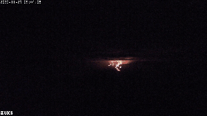
Featured image: USGS, saved on November 30, 2022, at 8:20 a.m., Pacific. Public domain.
