
- Global Volcanism Program (GVP) page
December 11, 2025: I’m updating all these posts, and while HT-HH isn’t showing any activity at the surface, results reported in September 2025 from a research expedition suggest, among other things, that the submarine edifice is unstable, which might make it collapse to some extent in the future and generate a tsunami.
This is not something overly alarming — one always has to be on guard for that in the wake of the volcano’s sensational behavior in 2022.
It does mean that the region’s people inhabiting vulnerable areas, particularly Tonga, need to be especially aware of tsunami risk and prepared, day and night, to move quickly to higher elevations and away from the coast — not an easy thing to do on small islands.
And there might not be any warning until the sea receded, if the possible collapse didn’t trigger an eruption or cause pre-collapse seismicity.
Since the reports also describes Tonga as being at risk from submarine landslides in general, I wonder if something like Japan’s vertical-evacuation tsunami towers would be a good idea here.
Original post:
Here is what new bathymetry images show after the January blast:
Sources listed in this tweet.
And here is a gorgeous shot of the stratospheric sulfur veil’s regional effects. Let us know in the comments if you have noticed unusual sunrise/sunset coloring and other effects where you are!
Today's pre-dawn sky showing signs that Tonga’s volcanic eruption has changed the chemistry of the upper atmosphere. Read more on this topic at https://t.co/Ur5ObmcKzS pic.twitter.com/YGGCthUavn
— Hauraki Gulf Weather (@GulfHauraki) May 27, 2022
https://platform.twitter.com/widgets.js
June 4, 2022: There were a couple of M4.9 quakes in the general area on May 30th, and a 6.2 today, but I have yet to see any authoritative source link it to Hunga.
This is one of the most seismically active places on the planet, so let’s just wait and see how things go at Hunga.
May 26, 2022: This excellent article sums up the new findings.
Good news: The January blast emptied the magma reservoir so thoroughly, they believe, that another big one isn’t likely for a millenium.
Still, there’s some ongoing activity, and scientists are going back in a few weeks to try to measure its rate. Between that ongoing study and the historic nature of this eruption, the post can stay pinned a while longer.
May 24, 2022: Check out the whole thread: amazing!
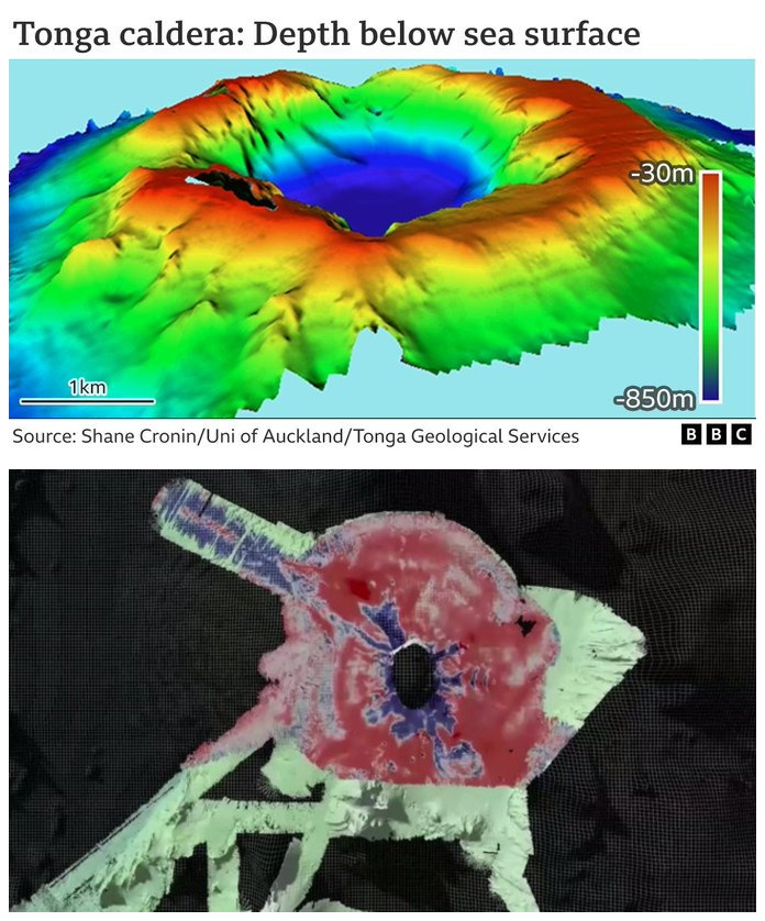
So now we have it. A full map of the caldera of underwater #Tonga #volcano Hunga-Tonga Hunga-Ha’apai. And wow is it deep! Its base is 850m below sea-level. Prior to the eruption, the caldera bottom was at a water depth of 150m. @scronin70 @tongaportal https://t.co/MK1gUIAVZJ pic.twitter.com/Krlec4Nja0
— Jonathan Amos (@BBCAmos) May 24, 2022
https://platform.twitter.com/widgets.js
May 22, 2022: Here’s some news about one of the bathymetry missions, posted about an hour ago.
I haven’t been able to confirm it yet on the agency’s website.
It’s all preliminary, so I’ll wait until an official statement is released to discuss it.
Update from NIWA. Among other points, the eruption may be continuing.
Even more surprising, they found the volcano still intact!
May 15, 2022, 12:56 p.m., Pacific: Tweeted within the hour.
What we know about the Tonga eruption, four months on https://t.co/Dlh0rEgFJP
— Shane Cronin (@scronin70) May 15, 2022
https://platform.twitter.com/widgets.js
I didn’t know the central caldera had deepened so dramatically.
Their view at this point:
The eruption began fairly normally, but Cronin says something happened to turbocharge it.
“What’s happening is because there’s magma erupting out the top, the shallow part of the volcano starts to collapse in on itself – this is this caldera process beginning to work.
“The lid, or the top of this caldera starts to fracture as it’s collapsing down … this fracturing allows the sea water to get in. We’ve already brought up that magma from 5km depth suddenly to the shallow depth and we’re dropping water in on top of it.
“We’ve got the perfect conditions for our very large explosion.”
Cronin says it’s a fairly unique set of circumstances – and all of these complex processes happened fairly quickly, within about half an hour of the beginning of the eruption.
May 13, 2022, 12:58 p.m., Pacific: Per a report released yesterday:
Based on Lamb wave amplitudes, the climactic Hunga explosion was comparable in size to that of the 1883 Krakatau eruption.
Here’s an article on that report.
Things are still quiet, apparently, but I’m keep this pinned because other studies are ongoing. By the way, I didn’t see mention of the unusually large tsunami in Peru in the new paper — wonder if the atmospheric and ocean waves combined there (layperson speculation alert).
May 4, 2022, 11:02 a.m., Pacific: No news yet on the bathymetry teams, but fortunately no news of further volcanic activity, either.
Here’s the detailed Global Volcanism Program report on the eruption and blast.
April 15, 2022, 3:30 p.m., Pacific: Well, the water over the caldera must have calmed down — Dr. Cronin went snorkeling in it recently. He didn’t take an underwater camera with him, probably because he knew it wouldn’t be of much use in surface waters, but he did note that there was a sharp drop-off, more than 200 m (656 feet); before the January blast, it was reportedly 150 m (a little over 490 feet) to the caldera floor.
He also took some video from a boat, including this showing the two islands are still there, but lower:
Here’s a view of the outer (western) flanks of Hunga Ha’apai- Not much change to coast but the top 30-100 m of cover deposits have been stripped off by the blast – leaving only mainly pre 2000 yr old lavas and agglutinates pic.twitter.com/lkPPDsf6Vq
— Shane Cronin (@scronin70) April 10, 2022
https://platform.twitter.com/widgets.js
I’m going to leave this up here, though, because research teams — including this one — are on their way to map the seafloor and caldera, so that experts can figure out what happened.
That’s good. I’m especially curious to learn what kind of topography might have sent 50-foot-high tsunami waves crashing into Peru, South America.
Meanwhile, here is a good article on the meteotsunamis that occurred on January 15, 2022, and also perhaps in 1883 when Krakatoa exploded in the Sunda Strait between Sumatra and Java.
Soon after the Hunga Tonga-Hunga Ha‘apai volcano erupted in Tonga, tiny tsunamis rippled thousands of kilometers away in the Caribbean and Mediterranean seas. How’d they get there? https://t.co/gZjtYtilCG pic.twitter.com/NFAttADHkp
— Quanta Magazine (@QuantaMagazine) April 15, 2022
https://platform.twitter.com/widgets.js
April 1, 2022, 11:45 a.m., Pacific: Just came across news of a new study offering one explanation why the January 15th explosion was so violent:
…a smaller eruption the day before, priming the volcano for a bigger explosion by sinking its main vent under the surface of the ocean.
That meant molten rock was spewing out straight into seawater, vaporizing it along the way and intensifying the eruption. The vaporizing seawater caused the lava to fragment into tiny bits of ash, the researchers suggest.
Combined with ice crystals in the upper atmosphere, the roiling cloud of material built static charges that drove a dramatic period of lightning. The frenzy of electrical activity was so intense, in fact, it represented 80 percent of Earth’s lightning strikes in its most active hour.
“We really just set out to try to understand what happened,” says volcanologist Melissa Scruggs from the University of California, Santa Barbara. “So, we gathered all the information that we could, anything that was available within the first few weeks.”
Scruggs and her colleagues think that almost 2 cubic kilometers (0.48 cubic miles) of material – weighing about 2,900 teragrams or 2.9 thousand million metric tons – was sent half way to space, causing violent ripple effects that were felt around the world.
The first two hours of the eruption were particularly violent, the researchers discovered, with the event starting at 5.02pm local time. After about 12 hours, activity at the site faded. It’s the largest eruption we’ve seen since the 1991 blast from Mount Pinatubo in the Philippines, the researchers say.
Shockwaves traveling through the Pacific caused multiple tsunamis across the world, often arriving earlier than expected because the models used to chart them were based on earthquake activity rather than volcanic eruptions.
It’s a warning about how dangerous submarine volcanoes can be, with the added ingredient of seawater. Many of these remain unmonitored – they’re in remote locations, out of sight of satellite imagery – but the damage they can do can be cataclysmic, as the Hunga Tonga-Hunga Ha’apai eruption shows.
“The volume of the eruption was not the big deal,” says geologist Frank Spera from the University of California, Santa Barbara. “What was special is how the energy of the eruption coupled to the atmosphere and oceans: a lot of the energy went into moving air and water on a global scale.”
Dr. Cronin (and probably others) are busy collecting ash samples in Tonga in order to quantify the eventual VEI designation for this eruption, as he explained in a reply to this question on Twitter (read the whole thread: in it, someone from the GVP also explained how they assign VEI ratings):
Reading up more about Jan 2022 #HTHHeruption and was curious about official VEI? I'm seeing some things saying VEI 5 but not on official sites like @SmithsonianGVP yet… @janinekrippner @smitchell_sci @scronin70
— Kirsten Stephens (@kibbysushi) March 31, 2022
https://platform.twitter.com/widgets.js
March 27, 2022, 9:13 a.m., Pacific: These sticky posts are accumulating, but I’m not ready to let this one fall back into chronological order just yet.
There is no new coverage online that I can find, but the general region is jumping (not surprising in a very active subduction zone) and there was a M4.8 near Hunga on the 19th of this month.
My general feeling is that the M5-ish swarm is slowing, but this was so unusual, it’s worth watching a little longer.
March 9, 2022, 11:38 a.m., Pacific: There really isn’t much to update: M5-ish quakes continue to occur, but nothing much else is available. On March 5, someone did post this caldera-region flyover (by whom, when, and what monitoring conclusions were drawn from it aren’t known to me):
#HungaTongaHungaHaapai#tongavolcanoeruption#tongatsunami #tongazo pic.twitter.com/Ew2s0STXpx
— Richard Minth (@RichardMinth) March 5, 2022
https://platform.twitter.com/widgets.js
I did read in Dr. Cronin’s paper that those are the tops of the two islands, which sank 30 meters after the January 15th blast. From the looks of that water, though, I doubt anyone is going to be sailing in there for a while to do bathymetry.
We’ll just have to wait and see. Some more.
February 22, 2022, 12:51 p.m., Pacific: Here is another view of that amazing plume, and more information from NASA about it:
The plume from Hunga Tonga-Hunga Ha‘apai behaved like a mega-thunderstorm that rose 58 kilometers (38 miles) into the atmosphere. https://t.co/FnZItxSm03 pic.twitter.com/4glaYv6825
— NASA Earth (@NASAEarth) February 17, 2022
https://platform.twitter.com/widgets.js
An EGU blogger also published a good review post of Hunga’s recent activity cycle, including more details about the June 15th blast.
Apparently Krakatoa in 1883 was even more powerful (there were no satellites then, but there was a Royal Society Krakatoa Committee in London).
This Naked Science docudrama from 2015 tries to present that eruption as realistically as possible:
If it doesn’t start at the big eruption, you can find it at 42 minutes 28 seconds in. But the whole documentary is good, though references to
Anak Krakatau are dated now.
Twenty-first century Tonga got off relatively unscathed!
February 18, 2022, 7:03 a.m., Pacific: No changes, but lots of strong quakes continue. A few more have happened since this tweet on the 16th:
While most abroad now have the #HungaTongaHungaHaapai eruption as a distant memory, locals and mother nature don't. The overnight M5.0 quake near the caldera is the 91st M4.5+ quake in the area since the eruption. Elevated volcanism & seismicity continues under the ocean's floor. pic.twitter.com/WOYTl5s10k
— Hauraki Gulf Weather (@GulfHauraki) February 16, 2022
https://platform.twitter.com/widgets.js
Also, yesterday they announced this news:
Incredible new analysis: parallax observations by GOES & Himawari show that the Hunga Tonga eruption sent its plume of ash and gas to the mesosphere.
This is likely a new record in the satellite era.https://t.co/wvqfYIHfIS #remotesensing #earthobservation #scicomm #gis #maps pic.twitter.com/cgD58EUvvx
— Joshua Stevens (@jscarto) February 16, 2022
https://platform.twitter.com/widgets.js
These satellite views of Pinatubo’s climactic eruption in 1991 are good for comparison.
Granted there was a typhoon in the area in 1991, and much more ash for convection to lift, but the vertical energy released by Hunga on January 15th apparently was even more than Pinatubo’s.
That’s mindboggling, as are Hunga’s global tsunami effects.
By the way, Earth is really “flexing its muscles” here tectonically —
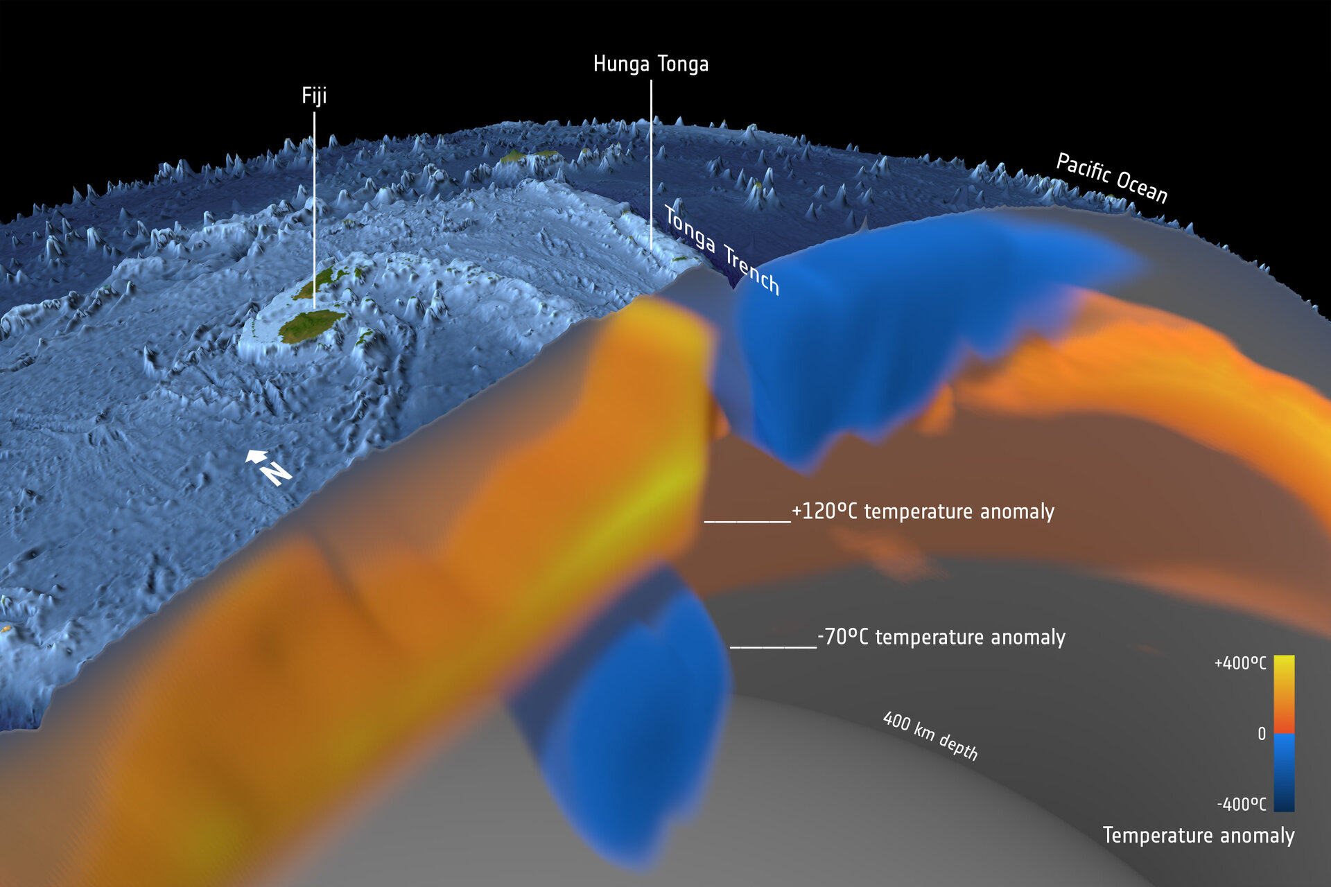
Hunga and the Pacific plate subducting underneath the Indo-Australian plate. (Image: ESA)
— but that basic tectonic pressure has to somehow translate into heat, associated thermodynamics, and geochemistry, which is possible in complex ways, but I don’t envy the volcanologists’ job working it all out.
I’ve seen some conferences about this mentioned on Twitter, and some online journals are even allowing limited free access to what work has been done on this once obscure submarine volcano.
Scientists are working hard on it, but they can’t monitor Hunga’s vital signs the way they would those of a land volcano.
We’ll all just have to wait and see.
Original post
New action hasn’t occurred at Hunga since the January 15th blast, so it is time to unpin that post.
This is going up in its place because there are weird things going on here, mainly:
- Strong seismicity continuing nearby (60-something quakes over M5 since January 15th, last time I checked), in a very complex tectonic setting (the Tonga-Kermadec subduction zone)
- The intense power of that blast (see articles linked below) with relatively little lava production: most volcanoes that have powerful explosions produce more, and without rocking the ionosphere with “the most powerful air blast since the 1883 eruption of Krakatoa in Indonesia.” (University of Hawaii at Manoa, link added)
- This “Nature” article, and this from Science News; volcanologists are still trying to figure it out, and that’s unusual
While awaiting developments, hoping that those will be a decrease in activity and eventually an end to it, here are some video compilations from Tonga, January 15th:
Shockwaves and tephra: Apparently the main force of a blast sequence that set Earth’s atmosphere ringing wasn’t directed sideways. These terrified but lucky people are less than 70 miles from the volcano.
With such a spectacle in the sky, few probably thought about a tsunami — until it came (and it came fairly quickly, before ashfall had blacked out their world):
Featured image: A30AEW&C
