
In a flood people turn first to barriers – levees, sandbags, flood walls, and the like. This works well, but failure can be catastrophic.
In emergencies, a spillway will drain flood waters away from the most threatened areas.
For long-term control of riverine flooding, though, you must engineer the river channel, deepening it and preventing bank erosion, so it will hold more water.
Rivers, floodplains, and people
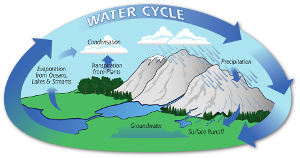
Rain falls to Earth as part of the water cycle. Once on land, it evaporates, sinks into the ground, or flows downhill as surface runoff, carving creeks, streams, and rivers as it travels toward the sea.
Rivers always have a slight slope, but their floodplains – the area that gets submerged when there’s more water than the river channel can handle – are usually flat or only very slightly sloped. This allows flood water to stand a while, depositing layers of mud that becomes rich soil after the flooding ends.
The river and floodplain’s agricultural, transportation, and trade opportunities draw in people, who build their cities and farms there.
Then the river floods again.
Now it’s no longer a normal event (though, of course, it’s still the same old natural cycle). This time, since humans and their property are at stake, it is a natural disaster.
Riverine flooding
A spectrum of flood types is possible from a river.

Flash floods occur from local storms that drop a lot of rain over the watershed in a short period of time.
Smaller streams and creeks in steep terrain are especially prone to flash floods.
It can also happen from the failure of a natural or man-made river barrier upstream.
A volcano may cause flash flooding in nearby river channels if it erupts under a glacier.
Another riverine flooding hazard exists near volcanoes even when they aren’t actively erupting. Rain or meltwater turns loose volcanic ash into a cement-like mud that pours down river drainages. Geologists call this a lahar, an Indonesian word for the phenomenon that happens often around that country’s many volcanoes.
Here is video of a massive lahar in 2007 at New Zealand’s Mount Ruapehu (which was not erupting at the time):
Not much can be done to prepare for a flash flood or lahar like that. You just have to try to stay out of harm’s way. Fortunately, most people do.
The most lethal floods in recorded history have actually been those that built up slowly. This is because a lot of people lived near the river and it remained flooded for a very long time.

Some of the millions of deaths attributed to each of those disasters were from drowning.
The majority of victims, however, died from famine, after livestock perished and crops failed or couldn’t be planted, or from waterborne disease and exposure.
China’s Yellow River (also known as the Huang He) is notorious for such floods. It is called the cradle of Chinese civilization but also has earned the names of River of Sorrow and Scourge of the Sons of Han.
The problem is sedimentary, my dear Watson.
Clearing the Yellow River’s channel
The Yellow River watershed covers over 290,000 square miles. Surface runoff there eventually flows into the river, each drop bringing with it a little bit of dirt.
This process happens in all rivers. The Yellow River is clear until its middle reaches, where it flows through the Loess Plateau. From this point onward, its sediment load is as much as a ton per 57 cubic feet of water.

There is a steep slope to the river channel here, and the fast-moving water can handle that much silt fairly well.
However, when the river gets into the plains near the sea it slows down, unloading much of its sediment onto the river bed and adjacent floodplains. Despite China’s best efforts at dredging and other measures, this silt deposition has raised both the river’s bed and its floodplain tens of feet above the surrounding North China Plain.
For example, at around 3:46 in the following video by the Henan Province Ministry of Water Resources, Yellow River Conservancy Commission (YRCC), you will see Yellow River shipping traffic in the distance, passing by at a level above rooftops in the foreground.
People have been trying to control the Yellow River for thousands of years. Even with today’s advanced technology and environmental science, the best-case scenario for reducing its sediment load will take almost 40 years.
That’s discouraging, but it’s not easy to control any flood-prone river.
Barriers help, but their failure can have deadly results. Spillways and evacuations are useful in emergencies, but the best long-term flood prevention involves the two-pronged approach of keeping the river’s channel as large and open as possible and protecting its banks and watershed from excessive erosion.
Next week, we’ll wrap this series up with a look at how the cities of Dhaka, Bangladesh; Jackson, Mississippi; and London, England, have endured severe flooding and the steps they have taken to prevent future disasters.
Did you like this post? Feel free to tip me via PayPal. Any amount is welcome, and thank you in advance!

Front page image: National Weather Service Portland
More information:
- Yellow River Delta. NASA Earth Observatory
- Why Rivers Flood – and How to Reduce Risk. Nature Conservancy
- Humans Have Been Messing With China’s Yellow River for 3,000 Years. Rachel Nuwer
- Riverine Flooding – Rivers, Creeks and Streams. State of California
- What are the elements of a flash flood and a river flood? University Corporation Atmospheric Research
- Case Study on the Yellow River Sedimentation (PDF). UNESCO
- Types of floods and flood plains (PDF). US Federal Emergency Management Agency
- Floods & Flash Floods: Introduction. US National Weather Service, Des Moines, Iowa
- Flood control. Wikipedia
- Yellow River. Wikipedia
