
April 1, 2025, 2:38 a.m., Pacific: About three hours ago, a seismic swarm began and just now lava reached the surface just outside the Grindavik barrier.
5:36 a.m., Pacific: Please see the links below for updates this morning.
The eruption is a surprise — it has proceeded slowly and with relatively low intensity, like the 2021-2023 “tourist” eruptions in Fagradalsfjall.
Lava and lava fountaining are still well within a kilometer of Grindavik, though, and the vent line slowly continues to expand toward town (and also northward — another unusual thing about this eruption is that its dike intrusion is actually longer (11 km) than the big one that formed on November 10, 2023).
While the lower than usual intensity helps, this might be a long eruption, like those in Fagradalsfjall. It’s still too early to say much about this one, though.
Links
Updates
April 8, 2025, 2:15 p.m., Pacific: Per IMO today (autotranslated), the sill definitely is inflating, and rather rapidly at the moment, but some time will have to pass before they can get a better idea of what sort of behavior it will settle into over the longer term.
The point: The Sundhnukar crater eruption series is not yet over. More dike intrusions and/or eruptions are likely to occur eventually.
Meanwhile, Dr. Haraldur Sigurdsson comments (autotranslated) on the strong quakes that came during this run and suggests that it would be a good idea (and feasible) to study the peninsula at greater depths.
April 4, 2025, 12:49 p.m., Pacific: I posted this at TalkWeather, too. Per today’s IMO update, Svartsengi is inflating again, but they can’t tell how much. Since the dike contents are still fluid, this raises the possibility that there still could be an eruption eventually somewhere along the new dike, perhaps at that north end.
They did say earlier that the dike came closest to the surface — about a mile down — in the Scogafell area, that northerly part where that one eruption happened. If it must erupt, that would not be a bad place.
They note that dike formation also deformed the plain a bit so it will take a week or so for them to sort out the actual magma volume that is accumulating now.
April 3, 2025, 3:8 p.m., Pacific: Check out this spectacular interferogram from the Icelandic Met Office today!
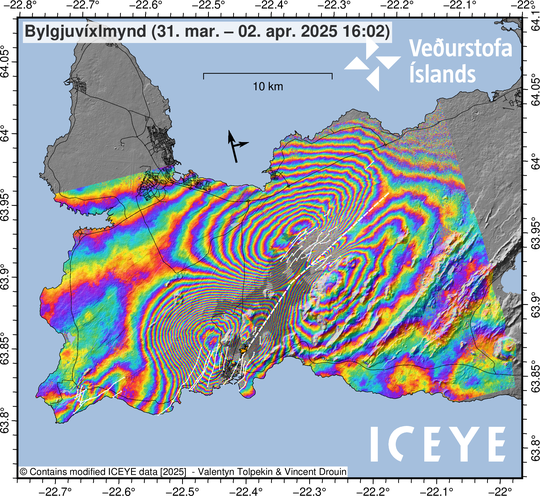
It shows the classic butterfly pattern of a dike plus a bull’s-eye from Svartsengi plain’s dramatic subsidence as the sill emptied out almost completely.
Here is their update today, via Google Translate:
Updated April 3 at 2:40 PM
• The event is not over, as a number of small earthquakes are still being measured in the northern part of the magma chamber.
• Less likely over time that a new vent will form over the northeastern part of the magma chamber
• There is still considerable uncertainty about the continuation of this event while a large number of small earthquakes are still being measured at the northern end of the magma chamber.
• Magma flow from Svartsengi into the Sundhnúk crater series has become so small that subsidence is no longer measured.
• Deformation measurements in the coming days and weeks will shed light on how the magma accumulation beneath Svartsengi develops.
Deformation measurements show that the northernmost part of the magma tunnel has reached the area almost 4 km north of Keilur.
Analysis of webcams, drone footage, and gas measurements show that the eruption, which began at 9:44 a.m. on April 1, ended at about 4:45 p.m. the same day. The eruption lasted just over 6 hours, making it the shortest eruption in this series of eruptions at the Sundhnúk crater series.
However, the event is not over, as a number of small earthquakes are still being measured in the magma chamber, mainly north of Stóra-Skógfell, although activity has decreased in the last 12 hours. Minor seismic activity is being measured in the southern part of the magma chamber.
Seismic activity at Reykjanestá, Eldey and Trölladyngja has also decreased, but there has been intermittent seismic activity there in the last 24 hours.
…
More unlikely over time that a new vent will form
Subsidence in Svartsengi is no longer measured, which indicates that magma flow from Svartsengi into the magma tunnel has become so small that deformation due to it is not measured by GPS stations on the surface.
It is becoming less likely over time that a new vent will form over the northeastern part of the magma tunnel, although there is still considerable uncertainty about this while a large number of small earthquakes are still being measured in the area. This assessment is based on the fact that subsidence is not measured in Svartsengi and therefore magma flow into the tunnel has become small. Also, the majority of the magma has already passed from Svartsengi into the magma tunnel and therefore it is unlikely that there is sufficient pressure for magma to break its way to the surface.
Deformation measurements in the coming days and weeks will shed light on how the magma accumulation beneath Svartsengi develops.
The risk assessment issued yesterday, April 2, is in effect until 3:00 PM tomorrow, April 4, with all other changes.
Clear deformation at the northern end of the new magma tunnel
Deformation measurements show that the northernmost part of the magma tunnel lies in an area almost 4 km north of Keilur. From satellite images and model calculations, it can be seen that the magma tunnel came closest to the surface about 5 km NE of Stóra-Skógfell, where its upper part lies at a depth of about 1.5 km.
Satellite images also show fissure movement across the northern part of the magma chamber in the area northeast of Litla-Skógfell.
Fissure movements are also visible within Grindavík town, although somewhat smaller than those that occurred in connection with the eruption in January 2024. Fissure movements were also measured on the Reykjanestá River following an earthquake of magnitude M5.3 that occurred on the afternoon of April 1.
April 2, 2025, 11:20 a.m., Pacific: This is from a post at TalkWeather.
Per IMO, Svartsengi Plain has dropped about 10 inches, and 90% of what was in the sill is now sitting in a dike that extends NORTH of Fagradalsfall and its pyramid of a mountain, Keilir.
The dike has really quieted down. Experts don’t expect an eruption anywhere on it, although they can’t rule it out since there is still low-level seismicity ongoing.
Is this first round of peninsula eruptions over? Volcanologists are waiting to see if the sill begins to reinflate. Even if it does, after this major change, they’ll have a tough time working out the new parameters for an eruption.
The broadest displacement in Grindavik yesterday was on the eastern side of town, which is interesting since the western side was the scene of much of the action on and after November 10, 2023. Overall, the town widened by about 20 inches.
Tectonically speaking, geologists note that, just north of town, there is an important change in the directions that faults take horizontally and vertically. It has to do with forces involved in the Reykjanes Ridge and Iceland hotspot interaction and has been mapped for decades.
Thorvaldur once told media that, because of this, he didn’t think eruption would occur in town.
What did come up there last year came through underground cracks, likely the ones around Hagafell, I guess, that directed some lava into groundwater and near the barrier during one of the past eruptions.
It seems possible to this layperson that the leading edge of the fissures that came through the berm yesterday marks the point where this tectonic pressure change begins.
Anyway, there’s no question about a connection between Fagradalsfjall and Svartsengi now. But the magma that came out of the sill that is so close to Grindavik erupted right away in a very Fagradalsfjall fashion — I wonder why.
April 1, 2025, 7:37 p.m., Pacific: Well, Grindavik weathered today’s eruption much better than expected, though media report some cracked roads and a broken geothermal pipe in one house from ground movements.
Had this been similar to any of the other Sundhnukur-area eruptions, that would not now be the case, what with the main vents opening just north of the lava berms and then crossing the berms and continuing southwestward:
- The fountains would have soared hundreds of feet into the air, flooding the area with lava that probably would have overtopped the berms even without the breakthrough.
- Through the berm, and then on toward town, a line of en echelon fissures would have spread quickly, soon sporting impressive fountains of their own.
- Even if the vents didn’t continue into Grindavik, parts of the town and probably that all-important harbor would have been inundated as the line peaked over many hours and then consolidated into just one or more main vents around the original eruption site, and kept going perhaps for months.
Thankfully, that didn’t happen.
Instead, there was a brief Fagradalsfjall-style bubbling of lava up out of fissures that opened more and more slowly until this movement stalled out; some low fountaining, which began to diminish in early afternoon and now, according to the Icelandic Met Office (autotranslated) has now stopped; and relatively little lava flow.

Icelandic Met Office
Yay!
The magma movement, though, is still going on. It’s huge, in fact — the second largest flow since November 10, 2023.
IMO estimates that some 15 million of the 22 million m3 of magma believed to have accumulated in the Svartsengi sill since that last eruption ended on December 9 has already flowed into this new dike, which is centered around Sundhnuk and at last report was some 20 km long, based on seismicity:

Warmest colors represent the most recent quakes. (Image: Icelandic Met Office)
As you can see, most activity is happening on the northeast end, and it far outnumbers events to the south. The boffins tell us that magma is still running out of the sill and heading north.
The good news is that it’s deep — almost three miles underground — and all that seismic activity shows that it is having difficulty breaking through its rocky container.
Even more reassuringly, they say that it shows no signs yet of heading up our way.
They can’t rule out another eruption or the opening of new fissures, probably in this northern area, but apparently it doesn’t seem likely in the short term.
Soon after midnight local time, an IMO spokesperson told Visir that the seismicity, while still constant, appeared to be less intense (fewer 3-pointers). Time will tell whether it actually stops, continues, or does something else.
As someone told the media today, nature is in control.
Featured image: Screenshot of RUV’s current Grindavik mosaic live cam.
