
A hundred and forty-one years ago today, on August 26, 1883, the first of a sequence of plinian eruptions occurred in a small volcanic archipelago out in the heavily traveled Sunda Strait, between Sumatra and Java.
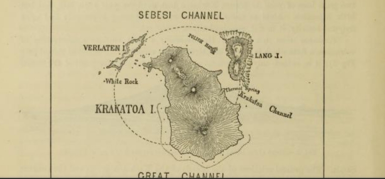
Figure 3 in the 1888 Royal Society committee report shows the archipelago as it was before the eruption. What’s left of Verlaten is now called Sertung; the Lang remnant is Panjang; and Rakata, the southernmost (bottom) of the three volcanoes that made up Rakata or Krakatoa Island, was sliced more or less in two as the rest of the island went down during caldera collapse. You can see Rakata’s cross-section in the image at the top of this post.
At least two out of three volcanoes on the main island — it was called Rakata because of the archipelago’s crab-like shape but also known as Krakatoa or Krakatau — had been active since May but not erupting as intensely as they now were.
A sequence of more and more powerful blasts would end the following day, as would more than 36,000 human lives — most of them snuffed out by gigantic sea waves caused by climactic events on August 27th that destroyed two-thirds of the main island and formed a new (and still active) Krakatoa caldera that now sits almost a thousand feet below the waves.
This was not the first cataclysm at Krakatoa. The “claws” of the crab Rakata — Panjang and Sertung islands — are remnants of similar explosive bursts that happened many tens of centuries ago.
Now there is a third rocky little island out there: Rakata, all that is left of the main island.
That big nineteenth-century blast won’t be the last one here, either.
Less than fifty years after the 1883 disaster, Anak Krakatau — “Child of Krakatau” — exploded up out of the strait waters and has been with us ever since.
As writer Simon Winchester puts it, Krakatoa is “…a volcano that absolutely and very visibly refuses to die.”
🌋🌋🌋
Fact-Checking Krakatoa
Who would have ever thought that we’d be able to fact-check the eruption special effects in Krakatoa docudramas and documentaries like this one from the History Channel in 2009 (shared online in 2021):
Fortunately, the 2022 eruption that showed us what the real thing looks like did not come at quite so high a cost in lives, though it was still terrible.
Science also is a process of fact-checking, one that never ends.
Much has been learned about Krakatau (its official name) since that History Channel documentary first aired.
Much has been lost, too, including most of the majestic but threatening Anak Krakatau cone that the History Channel emphasizes so dramatically.
A major flank collapse there in 2018 caused a tsunami that killed more than four hundred people and injured thousands more.
🌋🌋🌋
A three-part series of posts
In Part 3, we’ll return to that theory about mixing of different magmas presented in the History Channel documentary, looking at it in the light of new field discoveries. We will look at what might lie ahead for Anak Krakatau, too.
Part 2 will fill us in on volcanological events at Krakatoa after the 1883 eruption and through to the December 2018 Anak Krakatau flank collapse.
Right now, we’re going to close Part 1 with a timeline of Krakatoa’s May-August 1883 eruption, as suggested by Madden-Nadeau et al.
🌋🌋🌋
May 20 to August 27, 1883
There are eyewitness hand-drawn pictures of some of these stages in the Royal Society report. You might have seen some of them online.
I thought about including them here but decided not to. They need context to really be appreciated.
Given the changes in technology since the 1880s, they don’t seem very impressive — at least at first glance.
It’s probably better to get a little background along with them. The report itself can be technical and dry, but think of it as the headline maker it was — the eruption of Krakatoa in 1883 was the first time any large eruption had made global news in almost real time, thanks to submarine telegraphy.
Remember how we felt about Hunga Tonga?
Well, people of all sorts felt that way about Krakatoa, too. Eyewitnesses did what they could to oblige with sketches (despite the 1920s screencap of the new Anak Krakatau island that Wikipedia calls a photograph of the 1883 eruption, no photographs of it actually exist as far as I know).
Correction: That Wikipedia label is correct and I was wrong. The photograph —

Wikipedia, CC BY-SA 4.0.
— might be from the May eruption, if I understand Winchester correctly, and is what this image in the Royal Society committee report is based on.
The Royal Society then gathered everything they could and organized it as best they could.
They did such a good job that scientists still cite them in new research papers; as for the rest of us, well, we have seen those eyewitness images and watched the documentaries and docudramas that have been made using the details in that report.
Anyway, here is the basic 1883 timeline that Madden-Nadeau et al worked out:
May 20: One of the three volcanoes on the main island (Perboewatan volcano) begins having vulcanian to subplinian eruptions — vulcanian blasts are not unusual at Indonesian volcanoes, but the subplinian activity is rare.
May 22: The eruptions taper off.
May 23-26: No records of activity.
May 27: A group of observers visits the island and notes explosions in the volcano’s crater, occurring every ten minutes or so.
May 28 to June 19: While no specific records exist, Krakatoa reportedly “smokes” continuously throughout June.
June 19: More “smoke” starts.
June 24: A second column is noted for the first time, probably from Danan, the volcano next to Perboewatan. At the same time, the summit of one of those two volcanoes disappears — the records disagree about which volcano it was.
From now through the start of July, what few records exist suggest that eruptive activity continues to fluctuate.
July 3: A hazy red glow is seen, without any accompanying ash — probably a lava flow.
Throughout July eruptions, earthquakes, and occasional violent explosions continue out there on “the crab.”
AUGUST 26: At around 2 p.m., local time, a black eruption plume rises an estimated 26 km into the sky.
Explosions are heard every ten minutes.
An hour later, the first abnormal sea wave is seen, in Batavia (now Jakarta), while Krakatoa’s explosions are heard 670 km away.
By 5 p.m., everyone in Batavia can hear the explosions [people closer to Krakatoa and the Sunda coasts are fleeing for their lives, according to Royal Society reports, not stopping to take notes].
There is intense volcanic lightning during the night, and ships that dare to pass nearby notice an intense sulfur smell.
Tonga Geological Services personnel took this famous video the day before Hunga Tonga blew up.
AUGUST 27: Gasometers in Batavia record the most powerful explosions at 5:30 a.m., 6:44 a.m., around 10 a.m (the largest), and 10:45 a.m. Documentaries and docudramas cover what is happening to people over there now — the tsunamis, the strait-crossing pyroclastic density currents…
It’s all in the Royal Society report, too, in incredible detail.
Next time, 1883 to late December 2018.
Some lagniappe:
Referencing those sailors who made it through the Hunga Tonga tsunami, this is what happens if there is no deep water, say, if you’re in the Sunda Straits at a really bad time:
Post edited September 4, 2024.
Featured image: All that remains of Rakata Island after the August 27, 1883, eruption, in cross-section. (Image: Biblioteca Nacional de España, CC BY-SA 3.0)
Sources:
Madden-Nadeau, A. L.; Cassidy, M.; Pyle, D. M.; Mather, T. A.; and others. 2021. The magmatic and eruptive evolution of the 1883 caldera-forming eruption of Krakatau: Integrating field-to crystal-scale observations. Journal of Volcanology and Geothermal Research, 411, 107176.
Winchester, S. (2004). Krakatoa: The day the world exploded. Penguin UK. Retrieved from https://play.google.com/store/books/details?id=QjFjCGpuIacC
