Eldey, Catalogue of Icelandic Volcanoes (just in case)
University of Iceland Southern Volcanoes Facebook page
RUV (autotranslated front page). Look for a red box with white dots flashing when coverage is live (here is the last live coverage, with earlier coverage from this eruption here.
August 20, 2024, 2:56 p.m., Pacific: RUV reports (autotranslated) that a jokulhlaup from Vatnajokull might be starting, though it might take hours to be sure.
That probably explains the series of quakes in there yesterday. There are volcanoes, too, but right now it looks to be “just” geothermally caused melting from two sites.
It definitely is not directly related to the Reykjanes Peninsula events.
Grimsvotn, Bardarbunga, et al. might be trembling with outrage over the stress they’re under from Reykjanes when they have quite enough of their own tension to deal with thankyouverymuch ;^) , but they are in the East Volcanic Zone:
Peter Hermes Furian/Shutterstock
Hey, while we’re waiting for the next event on the Peninsula, why not visit Vatnajokull National Park?
August 20, 2024, 7:06 a.m., Pacific: In their update, IMO notes that six earthquakes in the M2 range have happened over the last week in the Sundhnuks area, two of them overnight.
And most of the others overnight were M1s.
There is also a subtle word change today: instead of saying that a dike intrusion or an eruption might happen “in the future,” it’s “from now on.”
Meanwhile, the pressure continues building, as before, and there are [layperson opinion] triggered stress-releasing [/layperson opinion] quakes in a number of centers in western Iceland, including some of the big guns — Katla, Grimsvotn, and Bardarbunga, mainly, although there was quite a swarm going on yesterday just labeled “Vatnajokull” when I checked vafri.is at one point yesterday. (Vatnajokull, third largest glacier in Europe, is home to several volcanoes, including Grimsvotn and Bardarbunga calderas).
The Northern Lights were spectacular last night, seen from mbl.is’s Sandholl cam, so I took a screenshot — the new feature image for this post.
When whatever is holding back the magma gives way, I’ll start a new post even if lava doesn’t break the surface (as I hope it doesn’t in the very unlikely event that the break is in the form of a November-10th-like dike-forming event).
August 19, 2024, 10:07 a.m., Pacific: It’s coming soon, I think, either as an eruption or a dike intrusion that would probably be somewhat stronger than the last one was this year.
That’s only layperson opinion. IMO says nothing like that but they are more definite in today’s update (Google translation) than I’ve ever seen them since following updates from November 10, 2023, on;
Magma flows and even eruptions in the Sundhnúks crater series can start at any time
Increase in seismic activity over the weekend
19.8.2024
Updated August 19 at 10:00 am
• Increase in seismic activity at the magma tunnel this weekend
•About 110 earthquakes were recorded yesterday, last week there were about 60-90 per day
• More than 50 tremors since midnight
• Seismic activity is very similar to the activity in the days before the last eruption
• Landris and magma gathering at a similar pace in the last few days
• The volume of magma under Svartsengi is estimated to be more than before the last eruption on May 29
In recent days, there has been an increase day by day in the number of earthquakes around the Sundhnúks crater series. About 110 earthquakes were recorded yesterday, August 18, but last week there were about 60 to 90 per day. More than 50 earthquakes have been recorded since midnight today.
Most of the earthquakes measured are below 1.0 in magnitude, but during the weekend two earthquakes were measured above 2.0 in magnitude. One of them was a short distance east of Sýlingarfell and the other between Hagafell and Sýlingarfell. The latter had a magnitude of 2.5 and is the largest earthquake recorded in the region since the last eruption.
The current seismic activity is very similar to the seismic activity in the days before the eruption that began on May 29.
In the future, it is likely that the Sundhnúks crater series will be affected by magma flows and even volcanic eruptions.
That was published seven hours ago. Another 2-pointer happened three and a half hours ago in the Grindavik area, per the vafri.is graphic, and there much lower-intensity swarming there ongoing.
🍿🍿🍿
August 18, 2024, 1:48 p.m., Pacific: Got so carried away on Talkweather that it was actually two hours after the linked mbl.is article’s update by the time I clicked the Save button.
The gist of this Talkweather post is short enough: the next eruption might be close.
But I’m a layperson and therefore must use so many words
August 14, 2024, 8:27 a.m., Pacific: First, in an unrelated but Dog Day Saturday Afternoon moment, there are apparently red foxes here now (autotranslated; you might need to go to the original URL via the little Google menu at the top for the video to work).
They are not native to Iceland, so perhaps someone’s pet escaped or was released during evacuations.
Lava must be a happy hunting ground for foxes. During the winter, webcams caught a native Arctic fox — sometimes called blue foxes because of their summer fur color — nosing around one of the Sundhnuks-area flow fields.
Regarding the impending volcanism, news reports say that IMO has been on standby for two weeks.
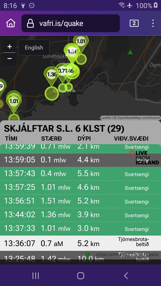
When I checked vafri.is just now, there were four M1 quakes shown that occurred north of Grindavik within a 20-minute interval.
And that’s it for direct news (indirectly, yesterday’s widespread seismicity appears to have calmed for the moment, but the graphic does show a 2-pointer in the Snaefells peninsula area and another one on the Reykjanes Peninsula in Brennisteinfjoll).
Stress release, probably.
Still waiting…
August 13, 10:31 a.m., Pacific: Different parts of the peninsula and adjacent areas are active and I am getting confused.
Per RUV (autotranslated), this is the area that Southern Volcanoes addresses in that post I mentioned in the last update:
I think it is the peninsula north of the area De Freitas described, actually. Still, it is rather isolated, I understand. (Snaefells is the “extinct” volcano where Jules Verne started that Journey to the Center of the Earth. Snaefellsjokull is the volcano shown on that graphic. What on Earth did outsiders do to sort out things before the Catalogue of Icelandic Volcanoes went up??!! 😉 )
The main thing is that IMO experts in the article are quoted as saying it is stress release, not new volcanism, causing the activity.
This layperson guesses stress is probably behind all the rockin’ today except in the Svartsengi/Sundhnuks/Grindavik area.
Could it be trying to erupt again but can’t for reasons perhaps related to the abrupt way the last eruption ended?
That’s a silly question only a layperson could ask.
Today’s IMO update notes the sill is still deflating — it presumably would inflate if eruption was blocked somehow — but the idea of stress release behind more frequent earthquakes elsewhere in the region lately might support my comments here yesterday about tectonics playing a role this time around…🍿
August 13, 2024, 9:31 a.m., Pacific: I just saw this post, from the Southern Volcanoes group via Facebook translation (which isn’t very good) about twenty hours ago. They are talking about the area, on this screenshot just now of the vafri.is graphic, marked by a 1.4 quake and others northeast of Reykjavik (full name obscured because many areas of the peninsula are lively today):
De Freitas in my Iceland series source list, who is writing about geothermal areas, is the only one I’ve read — a VERY small sampling — who includes that general area with the Reykjanes volcanic system.
The timing is interesting.
It’s an isolated part of Iceland. In other articles I’ve read, experts say that if an eruption occurs, there really isn’t much human stuff there, if anything, to damage.
The earthquake activity in the mountains by Mýrar reached new heights this weekend when the earthquake hit the area.
A 2.6 magnitude earthquake struck this afternoon, which is the largest earthquake recorded in the region since December 2022.
ENSu has repeatedly discussed these
disturbances. Persistent earthquake
activity has been in the area since 2021, or about as the activity on the Reykjaneskagi peninsula increased significantly. In this area, nearly no earthquakes had been recorded since the beginning of measurements.
Recordings of the earthquakes are at
Grjótárvatn and Dagmálafjall, about 25 km directly north of Borgarnes. On these paths there is an active fire station system that belongs to the Light Mountain Fire Station. In many places near the earthquake effect, small and medium-sized lava eruptions after the ice age.
Eldborg in Hnappadalur and Grábrók by Bifröst are probably the most well-known gigs connected to this system. Gigs and lava formed after the ice age can be found in many places, including in Hnappadalur, Hítardalur and Hraundalur. Small mobile images are also found in
the area and are the mark of a fire break under an ice age glacier.
August 13, 2024, 8:58 a.m., Pacific: Still waiting. Here is today’s IMO update, via Google Translate:
Measurements show similar signs as for the last eruptions in the Sundhnúks crater series
Seismic activity in the area has been increasing in recent weeks
13.8.2024
Updated August 13 at 12:00
Deformation and seismic activity show similar signs as before the last volcanic eruption in the Sundhnúks crater series
The volume of magma under Svartsengi is estimated at over 20 million cubic meters
Seismic activity in the area has been increasing in recent weeks. About 60-80 earthquakes per solar cycle.
Risk assessment unchanged from last week and valid until August 20, all things being equal.
Measurements of deformation and seismic activity show similar signals as for the last volcanic eruption in the Sundhnúks crater series. Model calculations also show that the volume of magma under Svartsengi is now estimated to be greater than before the last eruption that began on May 29. Landrising and magma accumulation continued for two weeks before an eruption occurred. Therefore, it must be assumed that magma flows and eruptions can start at any time, but previous examples show that it could be delayed.
Seismic activity in the area has been increasing in the last few weeks and shows a similar trend as before the last magma flows and eruptions. For the last seven days, the activity has been similar between days, and around 60 to 80 earthquakes are recorded per day in the area from Stóra-Skógfell to Grindavík. Most of the earthquakes are at a depth of about 2 – 4 km, the shallowest in the area between Stóra-Skógfell and Sýlingarfell.
Seismic activity in the Sundhnúks crater series since 1 December 2023 showing changes in seismic activity between eruptions and magma flows that have occurred since then.
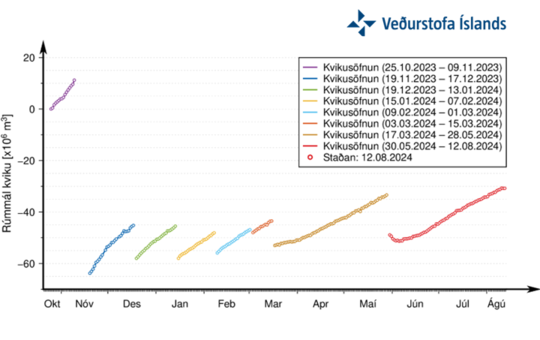
Deformation data shows that landris has been stable for the last week and a half but continues to slow slightly. It indicates that magmatic pressure is increasing under Svartsengi. Model calculations estimate that over 20 million cubic meters of magma has been added to the magma accumulation area under Svartsengi since the last eruption. This is a similar trend to that in the run-up to the last magma flows and eruptions, as the following graph shows.
A graph showing the development of magma accumulation and the estimated total amount of magma in the magma chamber under Svartsengi from October 25. Each magma flow has not exhausted the magma accumulation area, and therefore the starting position of magma accumulation under Svartsengi is different in each cycle after November 2023.
Risk assessment unchanged
The Norwegian Meteorological Agency’s risk assessment is unchanged from what it was before. The updated risk assessment is valid until August 20 without any changes. Scenarios are also unchanged…
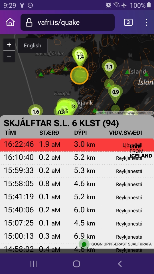
August 12, 2034, 7:21 a.m., Pacific: Well this is going on, per the current list at vafri.is:
That red-lined 2-pointer is actually the one that occurred at Hengill, farther to the east, in a swarm separate from these Grindavik quakes and more recently, but there is one of equal intensity shown on this graphic.
For the record, the papers I have read refer to Hengill as an entity outside the Reykjanes systems — it is, they say, a triple-point connection between the incoming Reykjanes Ridge and the other systems in Iceland, specifically, the South Iceland Seismic Zone and the Western Volcanic Zone, although other structures get involved before the mid-ocean ridge finally moves away from the hotspot melting anomaly under the island and transitions back through a Reykjanes-equivalent in northern Iceland (the Grimsey oblique rift, per many authors) and goes back to being typical (this layperson understands) in the form of the Kolbeinsey Ridge segment.
Yes, Iceland is very complicated structurally.
Things do seem weird right now, though.
A few days ago, I saw on the graphic that same swarming in the Fagradalsfjall area that had closely preceded the May 29th eruption and figured this was it — that lava would break the surface near the earlier sites again soon.
It did not.
Why not? I don’t know.
The IMO is using a monitored eruption at a similar tectonic setting — Krafla, 1975-84, in or near the Grimsey rift area — to help them say intelligent, helpful things about the current fires.
One thing they say over and over is that it took larger volumes of magma to trigger each successive eruption/dike intrusion in the Krafla Fires, and this seems to be happening again with the Svartsengi sill.
So, okay — we’ll have to wait longer for each eruption now.
Only this layperson gets the (totally unscientific) impression that the tectonics here play a crucial role. AFAIK, there was no Thorbjorn equivalent skating around in 1975-84, and while I understand that every set of Fires like Krafla and Fagradalsfjall/Svartsengi is a rifting episode (divergence of North America and Eurasia plates) and is made up of multiple rifting events (individual eruptions/intrusions), this layperson feels that something else contributes to the current fires on the Reykjanes Peninsula.
Don’t ask me what — I’m not a scientist and this is not a reasoned argument.
It’s not exactly a hunch, either.
As far as I know, there was no November 10, 2023-style plate separation event, with powerful quakes and a Great Magma Run, before the Krafla event.
And it seems significant, for reasons that I cannot articulate, that the Fagradalsfjall fires occurred in the one system area that did not erupt in the last peninsula volcanism cycle; also, that the Svartsengi sill intruded close to the site of the very last eruption, in the 13th century, of that previous cycle (the Eldvorp craters a few clicks southwest of Svartsengi — see drone pano linked above).
It isn’t just magma pressure dictating events here, I suspect — it is the tectonics involved with mid-ocean ridge reactivation locally.
It makes me wonder if Earth is done with rifting episodes here — of course, it probably is. Enormous amounts of energy stored for many centuries were released on November 10th and that much stress hasn’t even really started to reaccumulate yet.
But it looks to these very ignorant eyes as though whatever tectonics shut down the cycle last time must be overcome to start the next cycle — and about a third of Iceland’s population, important infrastructure and energy suppliers, and key things like an international airport and the nation’s capital, must go along for the ride.
It must be so difficult to understand the geology here, let alone predict what will happen next, and yet so much is riding on their information and actions — I don’t envy Iceland’s volcanologists at all.
Okay, maybe a little for their helicopter trips and access to eruptions and other cool stuff. 🙂
August 7, 2024, 7:29 a.m., Pacific: Still waiting, but there is an impressive microquake swarm at the eruption area currently showing at the earthquake link.
Per this interview (autotranslated), there are an estimated 19-20 million cubic meters of magma in the sill now, and based on processes noted during the only similar eruption to occur during the instrument monitoring era before 2021, at Krafla (northern Iceland), 1975-1984, they expect something — either eruption or dike intrusion (“magma run” in translations) — by the end of next week, at the latest (though Benedikt is very careful to say also that it could conceivably be later).
August 2, 2024, 9:03 a.m., Pacific: No changes yet but here is IMO’s update today:
Increased probability of magma flow and even eruption in the coming days
2.8.2024
Updated August 2 at 12:45 p.m
The number of earthquakes in the Sundhnúks crater series per day is slowly increasing
According to model calculations, enough pressure has built up in the system to trigger a new event in the coming days
As mentioned earlier this week, GPS measurements show that the land giant has slowed down a bit in the last few days. When that development in the land giant coincides with seismic activity similar to that measured in the Sundhnúks crater series yesterday, it can be an indication that it is approaching the next magma flow and even an eruption.
The National Weather Service’s response plans assume that a magma run could start at any time in the next few days, and it could even end in an eruption. If the sequence of events is similar to that of previous eruptions, the warning may be very short.
July 31, 2024, 10:50 a.m., Pacific: There was what might be called a doublet, though the 1-pointers happened almost half an hour apart, north of Grindavik this afternoon.
The Eldey area just offshore the peninsula tip has been restless, with some 2 and 3-pointers, but IMO spokespeople tell media (autotranslated) that it’s not related to the Svartsengi/Sundhnuks area situation.
They also say that the coming event could be either a dike intrusion (“magma run”) or eruption; if it’s an eruption, it most likely will happen in the same general area as earlier ones.
Fewer people are staying overnight in Grindavik, reportedly (autotranslated), and the police chief has said that police can’t be responsible for their safety.
And the wait goes on…
July 30, 2024, 5:48 a.m., Pacific: It sounds as though this wait might be almost over, per IMO’s update today:
Icelandic Meteorological Office
…
Updated July 30 at 11:45 a.m
• The number of earthquakes in the Sundhnúks crater series per day is slowly increasing
• According to model calculations, enough pressure has built up in the system to trigger a new event in the coming days
• GPS measurements show that the land giant has slowed down a bit in the last few days. The parallel seismic activity as measured yesterday, there are indications that it will be shortened to the next magma flow and even a volcanic eruption
• Risk assessment unchanged from last week
Yesterday morning, increased micro-seismic activity was measured in the Sundhnúkgiga series. The activity lasted for about 50 minutes and is probably a sign that pressure is increasing in the system. In the last week, the number of earthquakes per day has been slowly increasing.
According to model calculations that have been made in connection with the magma accumulation, enough pressure has built up in the system to trigger a new event on the Sundhnúks crater series.
GPS measurements show that the land giant has slowed down a bit in the last few days. When that development in the land giant coincides with seismic activity similar to that measured in the Sundhnúks crater series yesterday, there are indications that it is approaching the next magma flow and even an eruption. Therefore, there is an increased chance that it will make news in the next 7-10 days.
Risk assessment unchanged
The National Weather Service updated the risk assessment in light of the latest data. The risk assessment is unchanged from last week and is valid until August 6, all things being equal.
Scenarios published by the Norwegian Meteorological Agency on July 23 are unchanged
These are the most likely scenarios in the event of an eruption. Both scenarios are considered equally likely and are based on the initial power of the eruption being similar to the eruption in May.
Scenario 1 – Eruption with a source between Stóra-Scógfell and Sundhnúk (Middle of zone 3 on the hazard assessment map). Similar location to eruptions that began on December 18, 2023, February 8, March 16, and May 29, 2024.
The likely cause is a local series of small earthquakes between Stóra-Scógfell and Sýlingarfell, acceleration in deformation and pressure changes in boreholes in the area.
Very short notice (less than 30 minutes).
Lava could reach Grindavíkurveg at Þorbjörn in less than 1.5 hours and Grindavíkurveg at Svartsengi outside the defense walls in less than 3 hours.
Scenario 2 – Eruption with a source south of Sundhnúk, at Hagafell or south of Hagafell (Southern part of zone 3 on hazard assessment map and upper part of zone 4). Similar location to the eruption that began on January 14, 2024.
A likely precursor is a series of small earthquakes that start near Stóra-Skógfell or Sýlingarfell and move south, acceleration in deformation and pressure changes in boreholes in the area.
The eruption warning in this area would likely be longer than in scenario 1, but by how much is uncertain. Longer notice is determined by how far south the magma makes its way before reaching the surface.
Lava could reach Nesvegi and Suðurstrandavégur in less than 1.5 hours. A lava flow could possibly block escape routes on land out of Grindavík in about 6 hours.
In this scenario, lava could reach the sea east of Grindavík in 1.5 to 3 hours. If lava reached the sea, it could cause a local hazard due to the rapid cooling of the lava. At first there would be danger from pyroclasticity and gas formation, primarily hydrochloric acid (HCI). In a radius of about 500 m from the point where lava would come into contact with the sea, conditions would be life-threatening.
A magma corridor extending south of Hagafell will probably cause significant fissure movements in Grindavík.
In this scenario, the possibility that lava can arise within Grindavík must be assumed. One possibility is that lava emerging from a vent to the north of the ramparts at Grindavík can overflow fissures and then re-emerge through open fissures within the town limits.
The possibility of a fissure opening within Grindavík cannot be ruled out, but in that case it is considered most likely that a fissure would first open north of the town before a fissure opens within the town limits. The probability of an eruption within Grindavík is assessed as “considerable” in the current risk assessment.
The threat to Grindavik isn’t just from lava. As an IMO spokesperson told Visir today (autotranslated):
Jóhanna points out that a magma run without an eruption can even create danger and cause damage in Grindavík.
“Like, for example, what happened on November 10, there was a magma flow without an eruption, and we now saw what it did to Grindavík. It causes a lot of crack displacement even though it doesn’t erupt. It’s actually this deformation when the magma is pushing into the magma tunnel, something has to give way.”
Micro-seismic activity in the area
Minor earthquake activity was measured in the area yesterday and lasted for about 50 minutes, but Jóhanna says it is a sign of increased pressure and tension in the area that needs to be released one way or another.
“It might have been a swarm trying to get going, but it hasn’t gotten very far.”
Is this a sign of some magmatic movement in the area?
“Yes, this is definitely a sign that there is a lot of tension there, which could break out.”
In the last 24 hours, about 40 earthquakes were recorded in and around the Sundhnúks crater series, most of them in the southern part of the corridor. The seismic activity is therefore similar to the past 24 hours.
The activity is still relatively low, according to Elísabetar Pálmadóttir, a natural disaster expert at the Icelandic Meteorological Office. She says most earthquakes are small or under one in magnitude. However, one was measured that was of the size 1.5.
The latest GPS data and satellite images confirm that landrising and magma accumulation continues at a fairly steady pace over the last few weeks. If the rate remains the same, a new magma flow and even an eruption can be expected in the next two weeks.
July 27, 2024, 4:10 a.m., Pacific: A 3D image in this story shows the extent of the recently emplaced lava field (and the effectiveness of the barriers at Grindavik and at Svartsengi):
I don’t know how much longer Grindavik will be usable. IMO laid it on the line in an update this week:
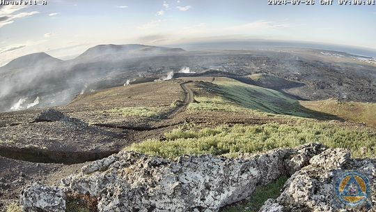
Screenshot from a surveillance camera at Hagafell taken at 7 July 26. The camera faces southeast. Steam rises from the crack outside Hagafell.
The chances of a magma flow and even an eruption are increasing
A magma flow without an eruption can be dangerous and cause damage
26.7.2024
Updated July 26 at 10:30 am
The seismic activity of the last few days has increased slightly, but is still quite low
Magma accumulation and landrising continues at a steady pace
Continue to expect a new magma flow and even an eruption in the next two weeks
A magma run without an eruption can create danger and cause damage in Grindavík
The seismic activity of the last few days has increased slightly, but is still quite low. More than 30 earthquakes have been recorded in the vicinity of the magma tunnel in the Sundhnjúk crater series in the past 24 hours and almost 130 in the past week. Most of them are less than one in size and are in similar locations as in previous events. For comparison, on the eve of the last eruption, more than 50 earthquakes were recorded daily.
…
The latest GPS data and satellite images confirm that landrising and magma accumulation continues at a fairly steady pace over the last few weeks. If the rate remains the same, a new magma flow and even an eruption can be expected in the next two weeks.
…
A magma flow without an eruption can be dangerous and cause damage
In a news release earlier this week, the Norwegian Meteorological Agency published two scenarios in the event of an eruption. In the second scenario, there was talk of the possibility that lava could arise within Grindavík, creating danger and causing damage. However, a magma flow without an eruption can also create danger and cause damage.
“In the 7 times that magma has flowed from Svartsengi to the Sundhnúks crater series, we have had eruptions 5 times. We therefore have to reckon with the possibility of a magma flow without an eruption”, says Benedikt G. Ófeigsson, head of deformation measurements at the Icelandic Meteorological Office. So far, magma has broken its way from the magma chamber under Svartsengi to the Sundhnúks crater series just east of Sýlingarfell and from there south towards Hagafell. “It is important to realize that if we get a powerful magma flow from Svartsengi, it is possible that the resulting magma tunnel will reach south of Hagafell and this will probably cause significant fissure movements in Grindavík, even if there is no eruption. The greatest damage to infrastructure and property in Grindavík is precisely due to fissure movements in the events of November 10, 2023 and January 14, 2024,” says Benedikt.
Overall risk assessed as “high” for Grindavík – probability of an eruption there considered “considerable”
The Norwegian Meteorological Agency issued an updated risk assessment at the beginning of the week, and it is valid until July 30 without any changes. The Norwegian Meteorological Agency would like to emphasize that the hazard assessment for each area is obtained by assessing the probability that a particular hazard will occur or will affect the defined areas.
During an interview (autotranslated) published on the 23rd, Dr. Pall Einarsson also highlighted the risks in Grindavik and the challenges of monitoring things right now.
The current IMO geoscientist note reads:
Volcanic activity in the Sundhnúks crater series. Yesterday, around 30 earthquakes were located at the Sundhnúks crater series. . Since midnight, there have been 6 small earthquakes in the area.
Landris is fairly stable and magma accumulation under Svartsengi continues, almost 16 million cubic meters of magma have accumulated there since the last eruption. 13-19 million cubic meters is the threshold considered sufficient to cause enough pressure to trigger a magma flow or eruption. According to according to the latest models, magma is flowing into the magma chamber at a rate of 4.4 cubic meters per second. Magma flow and then a possible eruption is likely in the next two to three weeks.
…
Written by geoscientist on duty Jul 27 05:00
July 25, 2024, 3:13 p.m., Pacific: Today is the first time I’ve noticed seismic swarming north of Grindavik since the last eruption, though there have been occasional quakes there, as IMO has noted.
That has been going on for a while today, but there is no comment on the IMO website about it yet.
July 23, 2024, 12:17 p.m., Pacific: In their update today, IMO reports that data indicate that either a magma intrusion or an eruption could occur in two to three weeks.
They list two possible eruption scenarios (via Google translation):
Eruption scenarios
The Norwegian Meteorological Agency has updated the scenarios that are considered the most likely in the event of an eruption. Both scenarios are considered equally likely and are based on the initial power of the eruption being similar to the eruption in May.
Scenario 1 – Eruption with a source between Stóra-Scógfell and Sundhnúk (Middle of zone 3 on the hazard assessment map). Similar location to eruptions that began on December 18, 2023, February 8, March 16, and May 29, 2024.
The likely cause is a local series of small earthquakes between Stóra-Scógfell and Sýlingarfell, acceleration in deformation and pressure changes in boreholes in the area.
Very short notice (less than 30 minutes).
Lava could reach Grindavíkurveg at Þorbjörn in less than 1.5 hours and Grindavíkurveg at Svartsengi outside the defense walls in less than 3 hours.
Scenario 2 – Eruption with a source south of Sundhnúk, at Hagafell or south of Hagafell (Southern part of zone 3 on hazard assessment map and upper part of zone 4). Similar location to the eruption that began on January 14, 2024.
A likely precursor is a series of small earthquakes that start near Stóra-Skógfell or Sýlingarfell and move south, acceleration in deformation and pressure changes in boreholes in the area.
It is likely that the eruption warning in this area would be longer than in scenario 1, but by how much is uncertain. Longer notice is determined by how far south the magma makes its way before it reaches the surface.
Lava could reach Nesvegi and Suðurstrandavégur in less than 1.5 hours. A lava flow could potentially block escape routes on land in about 6 hours.
In this scenario, lava could reach the sea east of Grindavík in 1.5 to 3 hours. If lava reached the sea, it could cause a local hazard due to the rapid cooling of the lava. At first there would be danger from pyroclasticity and gas formation, primarily hydrochloric acid (HCI). In a radius of about 500 m from the point where lava would come into contact with the sea, conditions would be life-threatening.
A magma corridor extending south of Hagafell will probably cause significant fissure movements in Grindavík.
In this scenario, the possibility that lava can arise within Grindavík must be assumed. One possibility is that lava emerging from a vent to the north of the ramparts at Grindavík can overflow fissures and then re-emerge through open fissures within the town limits. The possibility of a fissure opening within Grindavík cannot be ruled out, but in that case it is considered most likely that a fissure would first open north of the town before a fissure opens within the town limits.
“The scenarios we publish today are based on the latest data and analysis, and they give reason to be concerned that lava may reach the dikes at Grindavík,” says Matthew J. Roberts, director of services and research at the Icelandic Meteorological Office. . “We therefore need to be prepared for the possibility that lava that emerges from a fountain north of the defense walls above the town can find its way into the fissure system south of Hagafell and lead a lava stream into the town’s borders,” says Matthew.
“The experience from the eruption in January tells us that we cannot rule out the possibility of a fissure opening within Grindavík. But in that case, it is most likely that a volcanic fissure would first open to the north of the town before a fissure opens within the town limits”.
“Additionally, lava flow models show that in the event of an eruption at Hagafell, lava flow could block escape routes on land out of town within hours of the eruption,” says Matthew.
July 22, 2024, 11:58 a.m., Pacific: This is one of those simple Icelandic geology things that are so complex when you get curious and delve into them a bit.
The simple fact: There is a big crack in Hagafell that is old but reportedly got bigger during the May 29th eruption and also allowed lava to interact with ground water — causing those spectacular initial phreatic explosions — and provided a subterranean pathway for some of the lava to get close to the Grindavik northern barrier, and farther west, to surface near the US naval communications station (without damage).
A simple video: Someone took a drone out yesterday and examined the crack:
Layperson speculation: The “smoke” is probably caused by ground water interacting weakly with lava that’s still hot.
Oh! The complexities! — I got curious about what Hagafell is and poked around Google Scholar a bit, coming up with a paper on the Sundukhnur crater row area published on 2009, long before the Reykjanes Peninsula began to wake up (moderate jargon alert).
As I understand it, Hagafell is basically a collection of pillow lava formed during submarine or subglacial eruptions.
It’s not a solid chunk of rock, in other words, so cracks likely would form in between some pillow layers.
BUT…
My general impression is that a complex set of forces from plate tectonics and Reykjanes Ridge interactions with the hotspot anomaly (which is a little farther east, under central Iceland) are calling the shots here.
Per the paper that goes with this abstract, there is a major change in the peninsula’s fracture orientation from 60° to 79° right here, just north of Grindavik.
All this, even before magma moved into the area underneath Svartsengi.
Now magmatic pressure is a stressor, too.
And because this is a mid-ocean ridge, not to mention the hotspot contribution, no one really knows for sure what the underground structure and plumbing are like.
Volcanologists really have their work cut out for them here!
July 17, 2024, 7:04 a.m., Pacific: The following is IMO’s update yesterday, via Google Translate, but I want to highlight one point they make:
The latest analyzes of how the location of the eruption has developed in the last volcanic eruptions in the Sundhnúks crater series indicate that the eruption activity moves further south and closer to Grindavík with each event. Taking into account these analyzes and taking into account that since November 2023 the earthquakes have caused significant fissure movements within Grindavík, the risk due to eruption, lava flow and gas contamination is now assessed as “significant”, but was previously assessed as “several” within the area 4…
This layperson had noticed that, too, and was wondering where the next eruptive fissures would open.
From the online news, it seems as though only fishing companies and businesses that support them are in Grindavik. Many, though not all, Grindvikings appear to be moving on and the state is buying up the property (this is complex to an outsider, but I think that’s what is going on).
Here is the full text, translated by GT:
Magma accumulation under Svartsengi quite stable for the last two weeks
Likelihood of another magma flow and/or eruption in the next three to four weeks
16.7.2024
Updated July 16 at 15:15
Model calculations estimate that around 13 million cubic meters of magma have been added to the magma chamber under Svartsengi
Today, the amount of magma that has been added has reached the lower limit of the amount of magma that is believed to need to be added to start a new magma flow and even an eruption
Assuming that between 13 and 19 million cubic meters of magma would need to be added under Svartsengi to build up enough pressure to trigger a new magma flow and even an eruption, new models suggest that there is a very high probability that it will take place in the next three weeks
Updated risk assessment valid until July 23, all things being equal
Magma accumulation under Svartsengi has remained fairly stable in recent weeks. Model calculations estimate that around 13 million cubic meters of magma have been added to the magma chamber under Svartsengi since magma last flowed from there into the Sundhnúks crater series and the May 29 eruption began. Today, the amount of magma that has been added has reached the lower limit of the amount of magma that is believed to need to be added to start a new magma flow and even an eruption. The upper limit is around 19 million cubic meters of magma.
Assuming that between 13 and 19 million cubic meters of magma would need to be added under Svartsengi to build up enough pressure to trigger a new magma flow and even an eruption, new models suggest that there is a very high probability that it will take place in the next three weeks
However, it has been pointed out before that the experience from the Kraflu fires shows that as the number of magma flows increases, a greater amount of magma and thus more pressure is needed to trigger them. If it is assumed that about 20 million cubic meters need to be accumulated, as was seen before the eruption on May 29, that amount will be reached in the next three to four weeks. This is based on the fact that the magma inflow into the magma chamber below the Response Connector remains unchanged from the current level.
Updated hazard assessment
The latest analyzes of how the location of the eruption has developed in the last volcanic eruptions in the Sundhnúks crater series indicate that the eruption activity moves further south and closer to Grindavík with each event. Taking into account these analyzes and taking into account that since November 2023 the earthquakes have caused significant fissure movements within Grindavík, the risk due to eruption, lava flow and gas contamination is now assessed as “significant”, but was previously assessed as “several” within the area 4. This is equivalent to an assessment of this hazard within Zone 3.
These changes in the individual risks within zones 3 and 4 do not at this stage affect the overall risk assessment within them.
The risk assessment is valid until July 23, 2024, all things being equal…
July 9, 2024, 10:06 a.m., Pacific: For the first time since IMO declared the eruption over on June 22nd, their update describes increased seismicity over the November 10 dike again — they also mention more widespread seismicity in the region, too:
Constant landris under Svartsengi for the last few days
Magma flow continues under Svartsengi. Likelihood of another magma flow and/or eruption in the coming weeks and months
9.7.2024
Updated July 9 at 11:15 a.m
Almost 20 earthquakes have been recorded over the magma tunnel, the largest one measuring 1.3 west of Grindavík.
More than 260 earthquakes have been recorded on the Reykjanes Peninsula in the past week.
Deformation data shows that landris is continuing at a similar rate in recent days
Risk assessment updated. Almost unchanged, but the risk of lava flows has decreased.
Almost 20 earthquakes have been recorded over the magma tunnel, the largest measuring 1.3 west of Grindavíkurbær. This is similar activity as has been the past two weeks.
More than 260 earthquakes have been recorded on the Reykjanes Peninsula in the past week. Around 60 earthquakes were recorded in Lambafell in Þrengslum. About a dozen in Brennsteinsfjöll. Over 100 earthquakes were recorded around Kleifarvatn, over 40 to the east of the lake and over 60 to the west and southwest of the lake at and around the geothermal area in Seltún. Just under 40 earthquakes were recorded in Fagradalsfjall, all below 1.0 in magnitude and most at a depth of 7 to 10 km. About 20 earthquakes were recorded outside Reykjanestá in the past week and another dozen earthquakes further out on the Reykjaneshrygg about 90 km southwest of the country.
GPS deformation data shows that landrising under Svartsengi continues and has been at a similar rate for the last few days. A Sentinel 1 satellite image spanning the period June 25 – July 7 shows the same pattern. Model calculations based on deformation data continue to indicate that magma influx is greater now than before the May 29 eruption. These data continue to indicate that another magma flow and/or eruption is likely in the coming weeks or months.
The risk assessment has been updated, and remains valid until July 16. It is mostly unchanged except that in Area 1 (Svartsengi) there is less danger due to lava flows. The risk is therefore reduced from considerable risk (orange) to some (yellow). Lava flow risk is also rated lower in Zone 6.
It doesn’t sound like anything is imminent, but it’s time to start watching again.
As I understand it, the geologic record suggests that when the Reykjanes Peninsula is active (every eight centuries or so), all of its volcanic systems — from two to eight of them, depending on which expert you consult — will host eruptions, with activity tending to stay in one place for a few decades and then starting somewhere else.
According to a recent paper, it’s unlikely that more than one system can be active at a time.
So perhaps the 2021-2024 area — it doesn’t have a formal system name AFAIK, so call it Fagradalsfjall, Svartsengi, Sundhnuks, or whatever — will stay active for a while longer. The Icelanders are planning for it, anyway, having allotted more funds and raising the barrier defenses where needed.
But unlike its predecessors that last eruption went out like a candle when you blow on it, in this layperson’s opinion (FWIW).
There were some moderate earthquakes in the general region around that time, but nothing that was obviously linked to the eruption area. Still, one wonders if there was a sudden pressure change down there somewhere.
I do recall reading a hypothesis that peninsula volcanism might occur every 800 years or so in response to the mid-ocean ridge going into an extensional phase; then, a century or two later, volcanism here shuts down as the ridge switches over to a compressional regime for a while, and the peninsula is occasionally rocked by powerful earthquakes instead.
All of that — plus a host of complicating factors associated with the mantle melting anomaly/hotspot centered under the lithosphere supporting south central Iceland — it’s all way above my pay grade.
It’s worth mentioning as background, though, given the seismicity IMO describes. Maybe the Reykjanes ridge peninsula is stretching a bit as it wakes up and hasn’t yet quite started its usual program yet.