Eldey, Catalogue of Icelandic Volcanoes (just in case)
University of Iceland Southern Volcanoes Facebook page
RUV (autotranslated front page). Look for a red box with white dots flashing when coverage is live (here is the last live coverage, with earlier coverage from this eruption here.
MBL.is topic page (autotranslated). June 24, 2024, note:
They were hacked (autotranslated) yesterday; apparently the site is up now in Iceland, but I still can’t access it; June 26th — It’s available as of this afternoon. 🙂
Opening phase of March 16 eruption; this lasted until May 9, so scroll through their weekly reports for further details.
July 2, 2024, 1:44 p.m., Pacific: Looks like there might be a little breathing room between now and the next possible eruption, per today’s IMO update (Google translation):
• Landris is faster than before the May 29 eruption
• Magma flow continues under Svartsengi. • Likelihood of another magma flow and/or eruption in the coming weeks or months
2.7.2024
Updated July 2 at 15:50
• The rate of land erosion is higher now than before the eruption on May 29.
• About 13-19 million m3 left the magma chamber when the eruption began on May 29
• Likelihood of another magma flow and/or eruption in the coming weeks and months…
The rate of land erosion is higher now than before the eruption on May 29 and at a similar rate as it was at the beginning of the year, but there have not been large changes between events in terms of the speed of the land giant. A model based on deformation data shows that the inflow of magma into the magma chamber under Svartsengi is now 4-6 m3/s. At the beginning of the magma intrusion and then the eruption on May 29, it is estimated that around 13-19 million m3 left the magma chamber. The results of modeling calculations indicate that, based on the current inflow, the magma chamber under Svartsengi will be in a similar position as before the eruption on May 29 in three to six weeks. As of today, it is likely that a magma flow or eruption will start in the coming weeks and months…
Of note, when it gets close to the last top-volume-pre-eruption estimate, IMO has been mentioning a parallel with the Krafla Fires of 1975-1984 where, they say, a larger magma volume was needed to set off successive eruptions.
Time will tell…
PS: The Southern Volcanoes group notes on its Facebook page that there is no sign of inflow slowing from whatever deep source is supplying the sill; in fact, they write, it has been remarkably consistent. (Post is in Icelandic but Facrbook translates it if you are signed in.)
I think that might be a reaction to media quotes on the mbl.is website from Thorvaldur to the effect that the eruption is slowing and will soon be over.
Harald also is predicting an end soon.
My problem with that is this — the journalists never include balancing coverage, for instance, “Thorvaldur said earlier this year that the eruptions would be over by Easter; when asked for comment about why they have continued….”
If they ask for such comments, it doesn’t make it into the online coverage that I’m reading. The headlines skip from happy point to happy point, like a stone skipping across a pond.
Click!
It’s entertaining, but there are things in that pond that can suddenly jump out and bite you.
So I stick with those legally tasked with responsibility for watching them (though I enormously respect both Thorvaldur — Laki expert — and Harald, having read just a few of their papers): IMO, the University of Iceland, Civil Defense, and so forth.
June 28, 2024, 7:57 a.m., Pacific: People I follow in social media who know much more about it than I do spotted the GPS acceleration a few days ago. Here is IMO’s official update via Google translation:
Landris in Svartsengi continues with increased speed
New magma flows and/or eruptions are likely in the coming weeks
28.6.2024
Updated June 28 at 11:55
• The lava has an area of 9.3 km 2 and its volume is about 45 million m 3
• The land ice in Svartsengi continues with increasing speed
• Data collected in the coming days/weeks will help assess the situation with greater certainty
Seismic activity at Svartsengi and Sundhnúk is very low and few small earthquakes have been recorded in recent days. The lava moving towards the north side of Sýlingarfell continued to flow very slowly since the eruption ended on June 22 and has now completely stopped moving.
A team from the Institute of Natural Sciences and Land Survey of Iceland has processed data collected by experts from Efla, Verkís and Svarm during a drone flight over the eruption centers on June 24. The data shows that the lava is now 9.3 km 2 in area and the volume is about 45 million m 3 .
A map showing the extent and thickness of the lava bed that has formed in the eruption that began on May 29. The map is the product of the collaboration of many parties, but is based on the measurements of Verkís, Efla and Svarma from June 24. The map shows where lava has collected in a lava pond southeast of Sýlingarfell (red area) and the lava stream that flows from there north of Sýlingarfell. Gray areas show lava that has flowed in the area since December 2023.
The latest deformation measurements (both GNSS and InSAR satellite images) show that the land rise under Svartsengi continues. The speed of the land increased after the eruption ended and is now greater than what was measured before the eruption that began on May 29. The rate of deformation can be interpreted as that magma inflow into the magma sphere at a depth of 4-5 km continues
A wave interpolation image (InSAR) for the period 13 to 25 June shows that the deformation during this period is about 3-4 cm where it is greatest. The image is based on data from the Sentinel-1 satellite. Lava from Fagradalsfjall and Sundhnúks craters are marked with white outlines.
With these assumptions as a guide, it can be assumed that the system will behave in a similar way as before and that a new magma intrusion and/or eruption will occur again in the Sundhnúks area in the coming weeks. As of today, it is difficult to predict with certainty how the situation will develop. Data collected in the coming days/weeks will help assess the situation and possibly understand changes and trends within the magmatic system.
June 26, 2024, 12:09 p.m., Pacific: We get a break from eruption news, but an interesting paper was published today and I had some thoughts on TalkWeather about it.
Those thoughts also settled the whole horizontal/vertical question I had, too.
Here is the video from one of the study’s authors:
June 25, 2024, 11:09 a.m., Pacific: Another 3-pointer and some ongoing aftershocks happened at Blafjoll/Brennisteinfjoll just a little while ago:
IMO mentioned it shortly afterward in a geoscientist note, saying that it’s a known earthquake area. I checked my usual online news sources (mbl.is is still closed off internationally, and Iceland’s prime minister and other top-level government officials are putting the blame on Russia) — nothing geology related.
It’s still early; likely no damage was done, if it was even felt; and there is this ongoing serious incident with Russia.
Will see how news coverage goes on the Reykjanes geological front tonight and tomorrow.
(BTW, mbl.is is still active on Facebook.)
June 24, 2024, 6:31 a.m., Pacific: The Sundukhnur eruption seems to be over and — incredibly! — they seem to have stopped the lava incursions over the barrier near Sylingafell.
However, on a system just to the east:
Busy morning east of the eruption area close to Bláfjöll ski resort. The biggest quake was M3.1. According to the Met Office data, we've had 111 quakes in the last 48 hours. See the quakes live at Lava centre and experience an earthquake in the earthquake simulator. pic.twitter.com/6cNUlLCztm
The current IMO geoscientist note mentions the larger ones and points out that the last one here of such magnitude was back in 2021.
The Brennisteinfjoll (Blafjoll) system does kick up now and then, and is reportedly the source of highest seismic hazard to Reykjavik.
In recent months, spokespeople have noted that IMO has found no evidence of magma movement causing the quakes there, but let’s see if they address that again in updates or interviews.
Speaking of interviews, mbl.is was hacked (autotranslated) big time yesterday; apparently the site is up now in Iceland, but I still can’t access it.
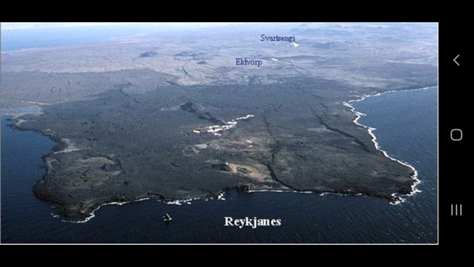
Finally, I had been wondering why they’re going with low-temp fields near Keflavik for backup in case they lose Svartsengi geothermal supply when there is an even higher-temp geothermal field than Svartsengi just to the west, called Reykjanes, at the tip of the peninsula.
Why not just fall back on that one? HS Orka, I understand, operates both and it’s not very far away, as this screenshot of a figure in this paper (PDF download) shows:
The Reykjanes and Eldvorp-Svartsengi geothermal field locations. It’s still mind-boggling that what we’re looking at is the Mid-Atlantic Ridge, having risen some two miles from its usual location, coming ashore as dry land.
Then I saw that little rock to the left of the word “Reykjanes” and just off the coast.
That rock is called Eldey and AFAIK it is the only sign above sea level of the Eldey volcanic system.
The Eldey system has been having cycles of a few moderately strong seisms and less intense swarms, most recently a couple of weeks or so back.
IMO was concerned enough to go put a GPS station on that rock over the winter, though I haven’t come across any updates since. The folks at Volcano Cafe write of dike intrusions there, which could be going on though data collection must be extremely difficult.
Anyway, with Eldey active and so close to the Reykjanes geothermal source — even without factoring in the likely surtseyan explosiveness of any eruptions in either the Eldey or Reykjanes system (which extends offshore, too), I now see why they wouldn’t hitch their star to that wagon!
Surtsey, 1963 and 1964:
June 22, 2024, 9:52 a.m., Pacific: The current note on IMO’s website —
Notes of a geoscientist
Eruption in the Sundhnúks crater series. The eruption that started last May 29 seems to be over. Yesterday there was little activity in the crater and this afternoon there was no activity when the Civil Defense flew a drone to check. Turbulence on nearby seismometers has also dropped and is now comparable to what was measured before the eruption began.
However, it can still be expected for some time that older lava will continue to flow slowly along Sýlingarfell on the north side and at the defense wall L1, where the spits have flowed over.
Written by geoscientist on duty Jun 22 2:34 p.m
The eruption went out like somebody blew on it! A good break for the workers on Svartsengi barrier L1, but the old lava keeps flowing and that ponded lava continues to be a threat.
I expect landrise is continuing, too, but there will probably be a full IMO update out soon with details.
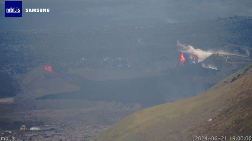
June 21, 2024, 1:24 p.m., Pacific: It has been a hectic 20-some hours at the barrier overtopping site in Iceland and also for me in the background.
This TalkWeather post and ones following it sum up the general situation, which through the mbl.is cam looked like this a little while ago:
The three overtopping flows were fairly strong yesterday but, amazingly, responders have managed to shut down two and are tackling the third now, per RUV (autotranslated).
The power plant reportedly is only about half a mile away and it’s all downhill. Sigh.
IMO was able to share some good news this afternoon, too:
Declining activity in the crater
Hrauntungur flows over a dike north of Sýlingarfell
21.6.2024
Updated June 21 at 14:55
In pictures taken this morning during a drone flight by the Civil Defense, it can be seen that the activity in the crater is decreasing. Lava flow from the crater is not visible on the surface, but may be in closed channels from it. However, there is still flow in the lava tubes that crossed the dike north of Sýlingarfell yesterday. A picture from the Public Safety’s web camera at Sýlingarfell shows the three lava tubes flowing over the park and machines working to contain the lava flow. The most active is in the lava tongue furthest to the west, which has moved forward by several meters and thickened in the last few hours. Gosórói is also decreasing and this is clearly visible on the seismometer of the Norwegian Meteorological Agency in Grindavík, as the attached graph shows.
Declining activity in the crater and a decrease in volcanic activity suggest that this eruption may end in the near future, but there is uncertainty as to exactly when. GPS measurements still show land in the Svartsengis area. It is an indication that pressure in the magma accumulation zone under Svartsengi continues to build, although the speed of the land giant is lower than before…
Who knows what will happen next!
Addendum: Well, they might announce today (autotranslated) that backup geothermal areas have been found for the district in case the power plant is damaged or lost.
As mentioned in the article, this search has been ongoing since the geothermal pipe rupture during those initial February 8th flows. I remember reading then that they would start looking but saw no follow-up news until today; it comes when the update can lift everyone’s morale.
Also as mentioned in the article, such backup sources can only provide enough heat to keep things from freezing up in midwinter — those are pretty low temperatures.
Per De Freitas in the source list, the high-temp geothermal area used by the Svartsengi power plant is 240-268° C (464-514° F) below 900 meters.
But a backup to keep things going for a while during emergencies is valuable, too!
June 20, 2024, 5:45 p.m., Pacific: They’ve begun water cooling again, reportedly (autotranslated), as the barrier has been topped a bit again.
Mbl.is cam screenshot just now:
I’ll have to be more careful — read it first on RUV, and from their description of the site as a barrier “not far from Grindavik,” I first assumed it was overtopping of the Grindavik barrier.
Never assume…
June 19, 2024, 11:54 a.m., Pacific: I got carried away at Talkweather again. Sorry! However, the eruption continues at the same level, more or less, without changes noted.
And reportedly, the lava cooling attempt was stopped.
June 18, 2024, 2:33 p.m., Pacific: No significant changes are reported. To stay updated, here is IMO’s afternoon report today (some links are in Icelandic, as the autotranslation URL change prevents them from working):
The eruption continues and lava flows mostly to the north
Landris continues in Svartsengi
18.6.2024
Updated June 18 at 13:50
• The eruption continuously erupts from one crater.
• Lava flows mostly to the north along Sýlingarfell
• Landris continues in Svartsengi at a similar pace. However, the speed is lower than before the eruption began
• Gas distribution forecast (autotranslated) and you can monitor air quality here.
The eruption has been quite stable for the last few days and continues to erupt from one crater. Lava mostly flows from it to the north, but part of the lava also accumulates on the south side of the crater. The lava that goes to the north goes into the lava pond at Sýlingarfell and from there further north where the lava thickens. Yesterday around noon, a small hole appeared in the crater on the west side and from there a lava stream flowed a short way west towards Sundhnúk, but that stream has not been active since yesterday. There is little or no seismic activity at the eruption centers.
In the period 3 – 10 June, the lava flow from the eruption was estimated at 10 m3/s, and since then there have been no significant changes in the activity of the eruption, which indicates that the flow is quite stable. Although the eruption is still going on, land is measured in Svartsengi (as in the last eruption). The results of modeling calculations show that the land rise in Svartsengi is due to a magma influx that is between 1-2 m3/s and is added to the magma accumulation area. If the accumulation of magma under Svartsengi together with the lava flow on the surface is combined, it shows a similar magma flow from depth as before the eruption. Even then, there is considerable uncertainty in model calculations and estimates of lava flow from the last week’s eruption, which can affect this estimate. The progress of the event will continue to be closely monitored.
The following graph shows the estimated amount of magma that has been added under Svartsengi between the eruptions or magma flows that have occurred since November 2023. The red line shows the estimated volume of magma that has been added to the magma accumulation area under Svartsengi from May 30 to June 17.
According to the weather forecast, it will be south-easterly today, but more southerly tonight. The gas pollution goes to the northwest and later to the north, and it can be assumed that pollution is measured on the northern side of Reykjanes. Tomorrow will be a slow change and later westerly direction. The gas pollution will then move towards the capital area. You can follow real-time measurements of various types of gas on the website loftgaedi.is and gas distribution forecast here (autotranslated).
Of note, they’re going to try to prevent overtopping of the Sylingafell barrier by spraying water on the lava, per RUV.
You might be familiar with the precedent they mention, if not the name Heimaey. It’s in the Westman Islands off the southern coast where Iceland’s East Volcano Zone is busy extending southward (most recently at Surtsey, south of Heimaey and the other Westman Islands).
They saved their harbor by spraying seawater on the advancing lava:
Update, 3:36 p.m., Pacific: The cooling attempt has just begun, per RUV (Icelandic, because video only works in the original page).
Update, 3:52 p.m., Pacific: Per mbl.is (autotranslated):
…At 8:36 p.m., the fire brigade started pumping water into the pipes.
“The situation is that we are here with several bulldozers and earthmoving machines pushing soil up into the garden where lava began to seep over. We are strengthening it and then we are going to inject water into it as well and cool the lava that is a combination there in this weakness,” says Einar Sveinn Jónsson, fire brigade chief in Grindavík.
About twenty responders are in the area, including from civil protection, Suðurnes fire protection and the fire brigade in the capital area.
Lay pipes from Svartsengi
“It just started peeking over the lava, went over the park a little bit, so we’re just trying to stop the lava flow in any amount over the park. […] We are going to start spraying on the lava that has come over, that the machines are pushing gravel into, we are just helping each other, both bulldozers and water to keep it down,” says Einar…
The mbl.is cam has been fogged in all day and evening but clouds are starting to lift and you can see the distant work site.
Still:
Live cam:
June 15, 2024, 3:07 p.m., Pacific: There really isn’t any new geological development; the lava is pooling a bit and also flowing towards the road, though slowly and with much inflation.
The sill is inflating again.
What you will really enjoy is this new video from Iceland Review — what one commenter calls, quite rightly, the coolest update on the Web:
June 12, 2024, 12:10 p.m., Pacific: The winds are stronger and air quality reportedly is back to normal everywhere. Lava has been ponding near Sylingafell again, but some might be moving downstream through lava tubes, too — developments on this are uncertain over the short term though the chances of another lava surge eventually are increasing.
From some news reports, there is still discussion underway on what to do with the north-south road section near Blue Lagoon that is lava blocked. One article mentioned the possibility of moving it west but nothing has been decided yet.
Roadwork on other routes that were covered early on continues.
Finally, mbl.is has an in-depth story (autotranslated) on the magma chemistry change.
June 9, 2024, 8:36 a.m., Pacific: There isn’t much news; apparently they are waiting to see what the lava will do next — pool up again near Sylingafell or keep oozing forward.
Apparently that rampart topping occurred near Sylingafell, not near the plant. So close to the pond, the flow was as high as the barrier and some “splashed” over.
Unfortunately, there doesn’t seem to be video of that event.
Firefighters are still at work in the area — they can’t get to some of the burning areas but it doesn’t sound as though any infrastructure is at risk from these fires.
The lava on the other side of the road, however, is now 700 meters from the geothermal pipe and the plant is at full operations, having expected this now for a while.
Better that the shielding gets tested in summer, just in case!
Just Icelandic released an excellent drone video of the highway-covering flow, with people in some scenes for perspective: 😍 but also 😥
June 8, 2024, 2:03 p.m., Pacific: This morning (Iceland time) the lava pond dam near Sylingafell gave way and a surge of lava got as far as the Svartsengi power plant barriers where it now sits about 800 meters away from the new geothermal heating transfer pipe that was installed after the catastrophic pipe rupture in February.
This new pipe is shielded, but that hasn’t been tested yet although lava now has gotten close twice.
The surge topped the power plant berm in at least one place — the small amount of lava set vegetation afire but it reportedly is not threatening the plant.
A considerable amount of lava has reached the berm now, and this autotranslating mbl.is article contains a pano so you can explore the area in detail.
There really isn’t much they can do, I suspect, to raise the berm or construct a backup barrier this weekend.
IMO did report this morning that the worst of the flow seems to be over now but that another such event could happen.
June 7, 1:51 p.m., Pacific: In their update today IMO addressed the UI findings. Via Google Translate:
Monitors possible changes in magma accumulation under Svartsengi
As mentioned in the last news update, it was the first time, since volcanic activity began in the Sundhnúks crater series in December 2023, that subsidence was measured in Svartsengi during an eruption. Yesterday, the University’s Institute of Geosciences published the first rock and geochemical data from the ongoing eruption. The data show that the chemical composition of the magma that is now coming to the surface is not different from that which has arisen in the last four volcanic eruptions in the Sundhnúks crater series, but is similar to the magma from the beginning of the eruption in Geldingaðalur in 2021. These results are a sign that the magma collection area under Svartsengi is changing. At the moment, it is not possible to assess exactly what kind of changes are taking place, but in the near future more data will be collected and analyzed to try to shed light on them.
This layperson never understood why the magma accumulated under Svartsengi but first erupted in long-quiescent Fagradalsfjall before coming to the Svartsengi area after the tectonic plate shift on November 10, 2023.
The substructure of the Reykjanes Peninsula, reading tells me, is not well understood. Geologists have divided it into parallel but tilted volcanic systems in varying ways, but generally set up as a geothermal area and an associated fissure system.
There is no solid evidence for these volcanic systems, per the reading, but it is a useful concept.
One primary point is that there are no central volcanoes on the peninsula — elsewhere in Iceland, there are, even at Krafla, whose 1975-84 Fires the current activity is compared to.
Because of interactions between the Iceland hotspot and the Mid-Atlantic Ridge, reportedly, these central calderas have fissure systems.
Eruptions can occur either in the caldera or on a fissure — or both, as happened in 1783-84 at Grimsvotn/Laki, though most of the activity was through the Laki fissures.
I’m not sure that geophysics “allows” caldera/fissure systems like that in an oblique rift like the Reykjanes Peninsula — but then my limited knowledge can’t let me say it’s impossible, either.
We’ll just have to wait — a long time! 🙂 — and see if this is what Earth is leading up to here or if it’s heading toward something else.
June 7, 2024, 8:42 a.m., Pacific: There isn’t much eruption news but preliminary data on current samples are out and this nerd finds the following fascinating (emphasis added):
…Our preliminary geochemical data likely suggests that a different magma has been accumulating under Svartsengi since the beginning of April. This magma was most likely stored in a separate, isolated mid-crustal reservoir distinct from the one feeding the eruption in March. The magma now erupting at Sundhnúksgígar has a K2O/TiO2 ratio resembling that of the magma which erupted in Fagradalsfjall at the beginning of the 2021 eruption. One possible explanation for this is that the two systems are connected at depth, close to the crust-mantle boundary. For the first time since the start of the 2021 Fagradalsfjall eruption, low K2O/TiO2 melts are dominating the eruptions…
June 5, 2024, 2:24 a.m., Pacific: Per RUV, Svartsengi may have stopped subsiding but IMO is not ready to issue a statement yet.
The activity is still high at that one crater.
The earthquake graphic doesn’t show anything at or near Hengill right now (Iceland is having stormy weather, though, and this can mask signals).
June 4, 2024, 12:42 p.m., Pacific: I really don’t know what to think.
The most clear-cut news is that the May 29th eruption declined rapidly and now is down to just one crater, per IMO about an hour ago in their update today (see autotranslating link at top of page).
But IMO also reports that Svartsengi plain continues to subside — a change in pattern.
[Layperson speculation]There have been a number of pattern changes since February/early March when Thorbjorn shifted to the west:
The more or less predictable eruptions in the Sundhnukur area every three weeks or so did not repeat after the February 8 eruption.
In early March, there was a small dike intrusion instead of the eruption that “should” have occurred around that time.
The eruption that began on March 16 was prolonged.
The sill continued to inflate during that eruption, oddly enough, despite the erupted volume going out, and after the eruption’s conclusion in early May, sill volume reportedly reached 20 million m3 or more before finally cutting loose on the 29th.
Some 15 million m3 reached the surface early on, reportedly. Presumably a sizable fraction of the remaining sill volume has erupted since then.
The sill now, reportedly, is subsiding to some extent, although the same IMO update via Google Translate also says magma is accumulating down there — that can happen with a reduced inflow, of course, but up until now the sill has expanded after eruptions wound down.
All that is understandable.
Here’s what I don’t get (keeping in mind that as a layperson there are severe limits to my understanding, anyway):
The intense microquake swarm at Fagradalsfjall that occurred at around the same time as the one at the site that did erupt on the 29th (see notes below) — and Fagradalsfjall’s apparent quiet ever since, although I have only checked the earthquake graphic intermittently.
An earthquake swarm at Hengill was reported (autotranslated) yesterday, and it continues. It seems to me that the ongoing eruption went into decline around that time, too. There should be no connection, since Krysuvik and Fagradalsfall, at the very least and probably other systems as well, lie in between; also, as I understand reading done to date, Hengill is different from the Reykjanes Peninsula volcanic systems — it is what boffins call a “triple junction,” being the point where the Reykjanes Ridge, West Volcanic Zone, and South Iceland Seismic Zone meet (boffins have much more to say about it and about those three features — not necessarily in agreement with one another, and I will not even try to get into it all, though the basic fact is worth mentioning just in case Hengill does have some long-distance effect on peninsula events).
Yet Hengill does have a central geothermal area like other peninsula systems, and this is where the current swarm is ongoing.
I can’t put it together OR identify the various points as unrelated to one another.
Of note, yesterday IMO spokespeople were quoted as saying the Hengill swarm had nothing to do with geothermal energy extraction; today the current geoscientist note says that injection can’t be ruled out.
This layperson, like Dirk Gently in another context, wonders about the interconnectedness of it all, having read that some volcanologists suggest the ~800-year cycle of volcanism on the peninsula might be regulated by an overall tectonic shift in the mid-ocean ridge (Reykjanes ridge segment coming in from the south; Kolbeinsey ridge segment exiting to the north; and all Iceland and its hotspot-built basalt plateau in between as an offset) from compression (no eruptions, but some powerful quakes) to extension (less frequent and less intense seismicity, but a centuries long bout of eruptions in various peninsula systems).[/Layperson speculation]
None of that is very illuminating — sorry! Just trying to organize my thoughts.
Haraldur wrote something recently about the Svartsengi eruptions coming to an end in July; he is an eminent volcanologist, writing for other volcanologists, but this layperson will read that post of his now and try to follow his argument.
June 3, 2024, 6:47 a.m., Pacific: There are no changes noted in news reports; this is shaping up to be another long one.
“There are three main streams of lava coming from the eruption centers. It flows mainly from two places. One crater in the south and two in the north. The lava from the last crater flows to the south in the same stream as it did in the last eruption, but also to the west and north with Sýlingarfell. The flow to the south doesn’t go far, but there the lava is piling up into a pond and could advance in the next few days, so we have to keep a close eye on it.”
Sigríður says that when it fails, it will be with a good force, so it is important to watch and make sure that no one is near when it happens.
This morning, the Norwegian Meteorological Agency met with emergency responders in Grindavík to assess the situation, including the status of the magma flow.
Per this news story (autotranslated), the crack noted in the Grindavik barrier is superficial and IMO says there is no evidence of magma below it — the steaming is just from the area being so hot.
Lava is nearby — besides the flow field from the 29th, the Southern Volcanoes group got an image of small ash emissions in that area outside the barrier; it’s circled in the image in their original Facebook post.
June 2, 2024, 4:53 a.m., Pacific: On the cam, that steaming area near the barrier appears much smaller; the likelihood of explosions or eruption there is probably reduced (layperson opinion).
Benedikt told RUV that the power of the eruption is reduced from Thursday but by so little that it could mean that this will turn into the longest eruption yet in the series.
That seems likely to this layperson, too, because the March 16th eruption’s main crater has reactivated. The one north of it is still going strong, too.
So, “tourist eruption” like Fageadalsfjall, then, given that the flow at this time isn’t directly endangering people or their stuff?
Perhaps, but this time there is an entry fee. Visirreports (autotranslated) that crowds are at the Blue Lagoon, which will soon reopen (if it hasn’t already — I’m not sure), and the story emphasizes that the view of the eruption from the parking lot is superb.
Only those with Blue Lagoon tickets can watch it, though, and police are not allowing anyone to walk over there.
I don’t know how wise it is to congregate so close to an active vent area where there is ponded lava that threatens the main escape route, but that’s what they’re doing.
June 1, 2024, 11:07 p.m., Pacific: Here is Morning Paper’scoverage (autotranslated) of what they call a crack and of the eruption overall. Note that some of the lava has ponded at Sylingarfell — if that gives way, then a downstream surge could be problematical.
June 1, 2024, 4:56 p.m., Pacific: I had to go out today and dreaded checking the eruption news and cam just now, after getting back and settling down, but there have been no dramatic developments yet.
However, about a half hour ago, someone posted images and a short video of the venting area as comments to the original post.
You can clearly see that it is within the barrier.
The Southern Volcanoes group noted that the area is in line with the southernmost extension of Wednesday’s erupting fissure line.
This wouldn’t be the first time a delayed fissure opening has occurred near town — last time it happened, the small fissure erupted, destroying three houses in Grindavik.
The currently steaming fissure doesn’t seem as threatening as that right now. Hopefully, it will settle down, as the earlier one did, and activity will continue up at the Sundhnukur crater area vents.
The activity up there tonight is gorgeous, and it is good to know that the resulting lava flow isn’t threatening anything.
It’s also a relief not to be waiting for it any more and a tremendous relief that Grindavik was not hit on the 29th. Everybody probably expected the town’s loss.
Maybe there is no news coverage of the current development because people aren’t quite ready for it yet. Also, Iceland’s having a presidential election today; don’t know much about the politics, but I believe the prime minister actually runs the country — the new PM reportedly got a lack-of-confidence public poll rating in the high 70th percentile — the president represents Iceland internationally.
Journalists must cover all that high-profile news. Maybe we’ll hear more about this lava apparently under the Grindavik barrier in a day or two.
June 1, 2024, 9:03 a.m., Pacific: The University of Iceland’s Southern Volcanoes group just posted that smoke (ryúka) and some tiny ash emissions have been coming from a crack very close to the Grindavik barrier on this cam:
They think it’s lava that has gotten in the Hagafell crack system and is coming into contact with groundwater.
May 31, 2024, 10:03 a.m., Pacific: Here is the latest IMO update, less than two hours old:
Updated May 31 at: 3:30 p.m
• The activity of the eruption quite stable last solar cycle
• Lava flows mainly between Hagafell and Sýlingarfell
• The average lava flow during the first four hours of the eruption was estimated at 1500 m3/s
• Gosmóda was seen in many parts of the country. You can monitor air quality here
• Gas pollution could be noticed in Ölfus and in the capital area in the coming days. Follow the gas distribution forecast here
• See updated risk assessment here
• The natural hazard expert’s comments will be updated as needed over the weekend
The activity of the eruption, which started around noon on May 29, has been fairly constant for the last solar cycle. Activity on the fissure is from the crater that erupted furthest from the last eruption, towards Sundhnúk and on the fissure north of it. Lava flows mainly from the crater towards the area between Hagafell and Sýlingarfell and also thickens near it. Lava from the northern part of the fissure flows most to the east. There has been no advance on the lava fields that crossed Grindavíkurveg towards Þorbjörn and west of the town. The lava around the old crater piles up in close proximity to the active crater.
There is little to no seismic activity in the area and the unrest has remained constant since the previous day. A considerable amount of deformation was measured in Svartsengi following the magma flow on Wednesday, but since then no significant changes have been detected that indicate that magma accumulation has started there again. Measurements over the next few days will provide more information on the development of magma accumulation under Svartsengi and the progress of the eruption.
The imaging team of the National Institute of Natural Sciences and Land Survey of Iceland has processed data from a measurement flight that took place about four hours after the eruption began, together with satellite images. Based on that data, it can be seen that the area of the lava on the afternoon of May 29 had already reached 8.7 km2 and its volume 24 million m3. The average lava flow during the first four hours of the eruption is estimated to be ~1500 m3/s based on the same data. Estimates of the flow of lava emerging from the craters have not been updated since then, but it can be assumed that now it is many times less than at the beginning of the eruption. For comparison, the average lava flow during the first hours of the eruption that began on March 16 was estimated at 1100-1200 m3/s. More about it on the website of the Earth Sciences Institute .
Gosmóda was noticed in many parts of the country
Southwesterly until Sunday, when the wind turns to the west. A little wet in many places, especially in the southwestern part of the country. Gas pollution therefore travels to the northeast and later east and could be felt in Ölfus and in the capital area in the coming days.
Gosmóða has been observed in many parts of the country during the last solstice cycle and has been measured by the Environment Agency. Soda is composed of very fine sulfur particles (SO 4 ) that have been created as a result of the chemical reaction of the soda mix with the moisture and oxygen of the atmosphere with the help of sunlight. When the day is long, as it is now, there is an increased chance of soda ash forming. Soda haze is not measured on SO 2 gas meters, but is visible as a gray-blue haze when a certain concentration is reached. An increase in fine particulate matter (PM 1 and PM2.5 ) can be an indication that SO 4 is present. You can monitor the air quality on the environmental institute’s air quality meters.
Next week there is a chance of north and north-westerly directions and therefore a small chance of gas and air pollution in built-up areas.
31052024so2
Attached satellite image (Sentinel-5p) taken at 1:47 p.m. yesterday, May 30, shows the SO 2 plume that traveled from the eruption to the east and was observed, among other things, in the Austfjörður.
Updated hazard assessment
The National Weather Service has updated the risk assessment in light of the evolution of the eruption. Zones 1, 5 and 7 go from high risk to considerable risk (orange). The main change is that the risk of gas pollution, pyroclastic falls and lava flows is now considered lower than before in those areas. There is still a very high risk in area 3 (purple), which is the Sundhnúks crater series and the source of the eruption. The overall risk in area 4 (Grindavík) remains unchanged and is still assessed as high (red), but the risk of eruption, lava flow and pyroclastic fall is estimated to be lower than before. The card remains valid until June 4.
Graphics can be viewed on the website page (autotranslated).
The Earth Sciences linked page only has articles up through the end of the last eruption, but that will be where new science updates appear. Here is an autotranslating link.
It’s too early to tell, but apparently another long-term eruption isn’t out of the question.
At least the lava flow rate is MUCH reduced and the molten material is flowing elsewhere than to Grindavik and environs.
I don’t know how much of a threat it is to the power plant and Blue Lagoon.
The road repair people reportedly say that there is too much coverage now and they want to wait until more is known about the eruption’s possible duration before they start to rebuild.
A blue haze covered much of the country not long after the eruption — the Gosmóða mentioned in this update. It is acidic sulfur haze, but according to other news articles as well as this update, it is not concentrated enough to set off gas alarm meters, though enough so to be visible.
This layperson suspects it comes from sulfur released during the phreatomagmatic explosions as the magma front passed Hagafell. At least one of those plumes was a tell-tale sulfurish tan-brown and I also saw some bluish vapor occasionally — a sign of SO2 presence.
Icelandic eruptions do release toxins sometimes; no widely broadcast warnings appear to be up and they are following it closely. We’ll see how it goes.
May 30, 2024, 7:00 a.m., Pacific: Well, it has lessened considerably and is now down to just a few vents in the central area near Hagafell.
The power plant thus far is unscathed. The lava was so hot and thin yesterday that it mostly just flowed around the barriers, Magnus Tumi told reporters yesterday, although University of Iceland Southern Volcanoes experts noted on their Facebook page yesterday that lava did overtop one small part and headed toward the inner barriers (which are not quite completed yet, I understand).
Surveys show that the ground under Grindavik is stable, which is terrific! It looked bad at first, but the worst effect on the town is loss of electricity; Grindavik’s heating and drinking water work.
The power company isn’t sure when power can be restored, per news reports — this is the new line they put in over the winter, and reportedly the masts are burning and almost all of the lines are gone.
The south coastal road into Grindavik is still open.
Some of us on the outside, who don’t have 1,100 years of personal connection to their hometowns, might wonder why it’s important to protect Grindavik.
On a purely practical level, the harbor is superb and I’ve seen online stats that show Grindavik contributing 6,000 tonnes of fish yearly to Iceland’s production.
And last month, Magnus Tumi reportedly said that the geologic record suggests that peninsula Fires (eruption series) have pauses that can be decades up to a century long. Grindavik could be safely inhabited by its people then.
On a human level — well, I was reading an unrelated article on Visir about a basketball game between two schools, Grindavik and Wal (held in an unthreatened area, of course). This game was during the eruption’s peak.
The article was a routine sports story but they included quotes saying that “all Iceland is with the Grindavik team tonight.” ❤
(A little rough on Wal, but they probably understood.)
In a similar way, many of us in the wider world are with Iceland during this time of testing.
May 29, 2024, 11:02 a.m., Pacific: The central part of this — the biggest eruption of the series thus far — is still maintaining respectable fountains, but the two ends are fading out, which is good since the newest fissures to the south are just a half mile or so from Grindavik’s lava defenses right now.
Lava came out initially, the boffins have most recently said, at 1,500 to 2,000 m3/sec. It quickly reached the Grindavik walls, topping them a little bit at one point but mostly just flowing around them.
Per the RUV live coverage about an hour ago (via Google Translate):
Magnús Tumi Guðmundsson, professor of geophysics, says the lava flow at the beginning of the eruption was between 50% and twice as much as in the last eruption. The eruption is starting to subside, but it is still quite powerful. “This is now the biggest event to date.”
He says lava flows rapidly at the beginning of an eruption when a large amount of magma comes up at once, and therefore stays hotter and thinner for longer. Magnús Tumi says that at the beginning of an eruption when it is so powerful, the lava flow cannot be controlled.
“But experience shows us that the dikes that have been built work very well for such thin-flowing lava. It just flows along the gardens. While it will not be thicker than so that it overflows the gardens. So they are working very well to keep the lava from Grindavík so far.”
So it can be expected that the lava flow will slow down a lot as time goes by and then the situation may become more similar to what it was during the last eruption.
Most roads to Grindavik are blocked and emergency responders evacuated a little while ago. The main power line to town was shut off early on and now is burning. Reportedly, it likely can’t be repaired quickly.
That and more can be read in the online news linked above (and autotranslated), and at TalkWeather, where coverage includes screenshots of some tremendous hydrovolcanic explosions that occurred as the fissure line was opening near Hagafell, where apparently a lot of groundwater had accumulated.
Those phreatomagmatic explosions generated a lot of ash near the ground but not much in air traffic lanes, per London VAAC.
There was a tiny one during the February flow, but these were magnificent and fairly guilt-free since they occurred far from most property and infrastructure (a road and possibly power lines might have been affected, though).
I thought I saw asphalt burning on cams covering the Svartsengi power plant area, but news reports still say only that the lava is approaching the plant area, all of which was immediately evacuated as the eruption began.
It does sound as though the new geothermal pipe shielding of concrete and earth will be tested. They are telling customers not to cut back on usage as a high pressure in the pipe will help it resist the inevitable high temperatures as lava covers the shielding.
The eruption began about four hours after I passed out went to sleep 😉 and I got up about an hour later. Will see if there is any way I can capture the start on one of the YouTube cams.
May 29, 2024, 7:34 a.m., Pacific: I just couldn’t sray awake past 2 a.m., and am not surprised by the news:
The volcano erupted
29.5.2024
Updated May 29 at: 2:15 p.m
Heavy flow south of Stóra-Scógfell approaching Grindavíkurveg
The lava has flowed about 1 km to the west during the first 45 minutes of the eruption.
At: 14:05 the eruption is now about 3.4 km long
The crack has extended further south and is about 300-400 meters north of the March-April crater.
The flow rate of lava is roughly estimated at 1,000 km 3 /s
The lava has flowed about 1 km to the west and there is a large flow south of Stóra-Scógfell, which approaches Grindavíkurveg. When it was a little over two o’clock, the fountain was about 3.4 km. The first crack has reached the farthest to the south and is about 300-400 meters north of the crater that was formed in the eruption that started on March 16. The outflow velocity of the lava is roughly estimated at 1,000 km 3 /s. Approximate location of the eruption. Click on the map to see it larger. Gas pollution is reaching the southeast and later east today, and it could therefore be felt in Selvogi and Ölfus. Tonight, the wind direction turns to the southwest, and therefore gas pollution is carried to the northeast, and it could be felt in the capital area tonight and tomorrow (Thursday)… Updated May 29, 2024, at 12:50 p.m
Fissures are still opening to the south:
May 28, 11:25 p.m., Pacific: There is a very intense swarm of microquakes showing on the vafri.is graphic, north of Grindavik, over at least the last five hours:
I wonder if this is it.
Here is IMO’s May 28th update via Google Translate:
Updated May 28, 2024, at 18:30
• Deformation data show that landrising at Svartsengi continues continuously
▪︎ About 20 million cubic meters of magma have been added to the magma chamber since March 16
▪︎ Continued likelihood of a new magma flow and another eruption
▪︎ About 400 earthquakes have been recorded in the last seven days
▪︎ Eruption warning may be very short
In total, around 400 earthquakes have been recorded in the last seven days near the Sundhnúks crater series. The largest earthquake was 2.2 magnitude at Sundhnúk. The activity spreads from Grindavík northeast to Stóra Skógfell along the magma corridor. Yesterday, close to 100 earthquakes were recorded in the area, and so far today, almost 70 earthquakes have been recorded. Since the end of the eruption, on May 9, most days between 40 and 60 earthquakes have been recorded, but on occasional days around 80 earthquakes, with the exception of May 24 and 25, when significantly fewer earthquakes were recorded due to strong winds. Therefore, there seems to be a visible increase in the number of earthquakes since yesterday.
Landris at Svartsengi continues at a constant rate indicating that magma continues to accumulate in the magma chamber beneath Svartsengi. Model calculations estimate that about 20 million cubic meters of magma has been added to the magma chamber since the eruption began on March 16. There is no evidence to suggest that it is reducing the flow of magma into the magma chamber. All that can be estimated is that there is still a high probability of a new magma flow and another eruption. However, there is considerable uncertainty in the system about when it will happen and also exactly where it will occur. However, it is most likely that a magma eruption will take place in a similar direction to the six magma eruptions that have occurred since November 2023. It is likely that the warning will be short.
…
Last week, minor pressure changes were measured several times for a very short time in HS Orku’s boreholes in Svartsengi. Such changes have not been observed in the last three days. It has previously been stated that the signs of a new magma flow were local small earthquakes in and around the magma tunnel, acceleration in deformation together with pressure changes in boreholes in the area. It can be assumed that greater pressure changes will be measured in the run-up to magma flow, along with changes in other measuring systems.
The risk assessment is unchanged from the last version, which is valid unchanged until June 4.
Since the earth’s crust in the upheaval zone between Stóra-Skógfell and Hagafell is heavily fractured, it is likely that magma will have an easy way to the surface, and therefore the upheaval will not necessarily be accompanied by high seismic activity. The warning of a new eruption can therefore be very short or even non-existent. It is therefore very dangerous to be on the road in zone 3 as defined on the Norwegian Meteorological Agency’s risk assessment map.
Will keep watching for a while.
ADDENDUM, 11:50 p.m., Pacific: Just noticed that Fagradalsfjall is swarming, too.
May 26, 2024, 10:01 a.m., Pacific: RUV reports (autotranslated) that an estimated 19 million m3 of magma are sitting in the sill now and Svartsengi plain continues to inflate.
IMO continues to say that an eruption can start at any moment, and they still think it most likely to happen where the rock is open and hot — the Sundhknur area.
Since 19 million cubic meters is the sill volume just before the first eruption on December 18, 2023, this seems like a good time to start a new post (older blogging on these events and other Iceland posts are available in the “Iceland” menu category).