
- Status: Orange, but —
El nivel de actividad naranja 🔶 del VNR nos indica que debemos estar preparados para una posible erupción de magnitud considerable. Como existe la probabilidad de que el volcán alcance el nivel de actividad rojo, este es el momento de tomar medidas de prevención⛑️ pic.twitter.com/jRoZPkXZEG
— Servicio Geológico Colombiano (@sgcol) May 1, 2023
https://platform.twitter.com/widgets.js
The take-away here: Ruiz might wind up steadily, if that’s on its agenda, or it might just give them a few minutes’ notice before the “big one.”
- Interactive official hazard map (autotranslated), via Relief Web; En español
- USAID April 4th map (autotranslated) posted on May 18 at Relief Web.
- Links to webcams, public data, and other information.
- Update archive.
Update, May 21, 8:23 a.m., Pacific: The biggest news that I’ve found this morning still has to do with the recent change in hazard zones.
As far as I can tell (not far really), things are still very much “Rock🔁Hard Place.”
Civil Defense Tolima just uploaded this video. It’s in Spanish, but from what I understand of the transcript, this autotranslated article covers the gist of what they are saying:
Meanwhile, authorities in the city of Pereira (look for it on the hazard maps linked above) report (autotranslated) that tourist attractions there and in most of Risaraldas are open.
The volcano is still at ORANGE level, per this morning’s SGC update (emphasis by either them or me:
From 9:00 a.m. yesterday (May 20) until the time of publication of this bulletin, the seismicity associated with rock fracturing inside the volcanic edifice showed an increase in the seismic energy released, compared to the previous day (May 19). This seismicity was located mainly in the northern sector of the volcano and in the Arenas crater, at a maximum distance of 6 km from it with depths ranging between 1 and 6 km. The maximum magnitude registered was 2.1, corresponding to the earthquake registered at dawn today at 03:41 a.m., located in the Arenas crater, at a depth of approximately 2 km from the top of the volcano.
On the other hand, the seismic activity related to the movement of fluids inside the volcanic conduits continued showing low levels in the number of earthquakes and in the seismic energy released, although this increased slightly compared to the previous day (May 19). Some of the seismic signals were associated with pulsatile ash emissions confirmed through the web cameras used for volcanic monitoring.
Regarding surface activity, the maximum height of the gas and/or ash column was 1300 m measured from the top of the volcano and it has presented a preferential direction of dispersion towards the north-northwest and west of it. Variations in the degassing of sulfur dioxide and the release of water vapor from the crater into the atmosphere continue. At dawn today, there was a report of a significant thermal anomaly at the bottom of the crater, from satellite monitoring platforms.
All these indicators ratify what the SGC has reiterated: the activity of the Nevado del Ruiz volcano continues to be highly unstable. It is possible that the levels of seismic activity, as well as the levels of degassing or ash output, decrease or be oscillating, in the sense of increasing on some days and decreasing on others. However, this does not imply that the volcano has returned to its normal levels of activity, so it is recommended not to get used to these oscillating changes in activity and think that it is a normal activity of the volcano.
Therefore, we reiterate that the activity of the Nevado del Ruiz volcano continues at ORANGE LEVEL, which indicates that there is a probability that in days or weeks it will erupt more than it has in the last 10 years. To change the level and return to the Yellow level, a prudential time is required where trends and patterns can be observed that allow us to infer the possible decrease in activity, aspects that the current activity of the volcano still does not show. For this reason, we warn that the level of activity of the Nevado del Ruiz volcano will remain at ORANGE LEVEL for several weeks. During this time, in the event of an acceleration of processes suggesting an imminent eruption or the eruption itself occurring, the activity level will be changed to Red.
We recommend that the community remain calm, follow all the instructions of the National Unit for Disaster Risk Management (UNGRD) and local authorities, and be attentive to the information provided by the Colombian Geological Service on the evolution of the state of the volcano.
The level of activity of the volcano remains at ORANGE LEVEL of activity or (II): PROBABLE ERUPTION IN TERMS OF DAYS OR WEEKS.
The COLOMBIAN GEOLOGICAL SERVICE will continue to monitor the evolution of the volcanic phenomenon and will inform in a timely manner about the changes that may occur.
For more information visit the following link:
https://www2.sgc.gov.co/Noticias/boletinesDocumentos/Forms/AllItems.aspx
By the way, I underline the distance from Arenas Crater (6 km today) because I saw a volcanologist on the PBS Nova special on “killer volcanoes” in the 90s mention a measurement like that as evidence that a lot of magma was under Pinatubo in 1991.
Dr. Makario Londoño mentions that a lot of magma is under Nevado del Ruiz, too.
While I sympathize strongly with everyone who is affected by this crisis, I also think it is important to emphasize reality, too: there is a lot of magma down there and it might give volcanologists just minutes’ notice if and when it decides to punch its way through to the surface and up into the sky.
Again.
In other news, an ash advisory was issued overnight. It has ended, though they do note the crater hotspot and mention that new emissions are possible.
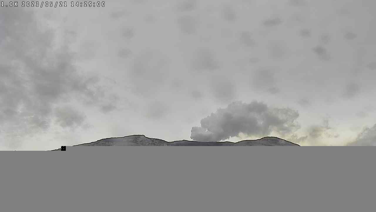
The fairly recent summit cam image shows a strong steam plume, and there are ashy rain droplet marks on the lens.
Featured image: Ric Photography/Shutterstock
