
- Status: Orange, but —
El nivel de actividad naranja 🔶 del VNR nos indica que debemos estar preparados para una posible erupción de magnitud considerable. Como existe la probabilidad de que el volcán alcance el nivel de actividad rojo, este es el momento de tomar medidas de prevención⛑️ pic.twitter.com/jRoZPkXZEG
— Servicio Geológico Colombiano (@sgcol) May 1, 2023
https://platform.twitter.com/widgets.js
They don’t usually make such tweets daily. See May 1st 5:04 p.m. update below.
- Interactive official hazard map (autotranslated), via Relief Web; En español
- Links to webcams, public data, and other information.
- Update archive.
Update, May 11, 8:34 a.m., Pacific: There’s a strong whitish (steam, mostly) plume coming off Ruiz at the moment.
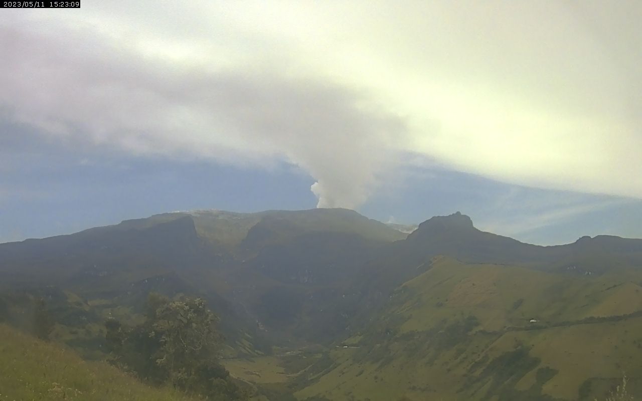
That’s from the Pitayo Sector cam.
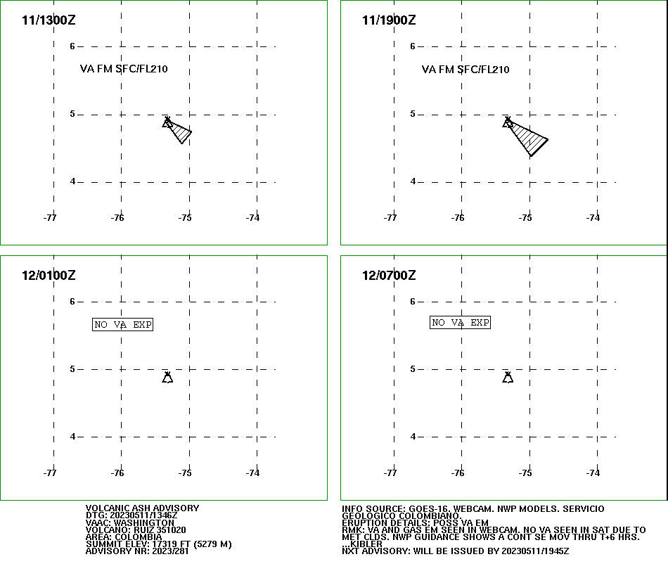
Washington VAAC also has an advisory up:
FVXX22 KNES 111346
VA ADVISORY
DTG: 20230511/1346Z
VAAC: WASHINGTON
VOLCANO: RUIZ 351020
PSN: N0453 W07519
AREA: COLOMBIA
SUMMIT ELEV: 17319 FT (5279 M)
ADVISORY NR: 2023/281
INFO SOURCE: GOES-16. WEBCAM. NWP MODELS.
SERVICIO GEOLOGICO COLOMBIANO.
ERUPTION DETAILS: POSS VA EM
OBS VA DTG: 11/1300Z
OBS VA CLD: SFC/FL210 N0453 W07517 – N0444 W07457
– N0434 W07507 – N0452 W07520 – N0453 W07517 MOV
SE 10KT
FCST VA CLD +6HR: 11/1900Z SFC/FL210 N0454 W07517
– N0437 W07443 – N0423 W07458 – N0453 W07520 –
N0454 W07517
FCST VA CLD +12HR: 12/0100Z NO VA EXP
FCST VA CLD +18HR: 12/0700Z NO VA EXP
RMK: VA AND GAS EM SEEN IN WEBCAM. NO VA SEEN IN
SAT DUE TO MET CLDS. NWP GUIDANCE SHOWS A CONT SE
MOV THRU T+6 HRS. …KIBLER
NXT ADVISORY: WILL BE ISSUED BY 20230511/1945Z
However, reportedly (autotranslated), there is little to no change in Manizales air quality, though ash occasionally reaches the city.
Here is Jhon/VIDJCB’s morning video, with time-lapse webcam movies that, when there is a break in the clouds, show the plume well:
He reads the SGC update, and here is the Google Translation from that, with emphasis by either SGC or me:
From 9:00 a.m. yesterday (May 10) until 9:00 a.m. today (May 11) the seismic activity related to the movement of fluids inside the volcanic conduits continued to predominate. This seismicity presented a slight increase in the number of earthquakes and in the seismic energy released compared to the previous day. Some of these signals have been related to pulsatile ash emissions, confirmed through the web cameras used for volcanic monitoring. Also, the recording of seismicity associated with rock fracturing inside the volcanic edifice continued, which showed a similar behavior in the number of earthquakes and in seismic energy compared to the previous day (May 9). The earthquakes were located to the southwest and east of the Arenas crater, at a maximum distance of 4 km, at depths between 2 and 5 km.
Regarding surface activity, the maximum height of the column of gases and/or ash observed was 1800 m measured from the top of the volcano, and the preferential dispersion direction of the column of gases was to the northwest – southwest and southeast. of the volcano. On the other hand, the variations in the degassing of sulfur dioxide and the release of water vapor from the crater into the atmosphere continue.
All these indicators ratify what the SGC has reiterated: the activity of the Nevado del Ruiz volcano continues to be highly unstable. It is possible that the levels of seismic activity, as well as the levels of degassing or ash output, decrease or be oscillating, in the sense of increasing on some days and decreasing on others. However, this does not imply that the volcano has returned to its normal levels of activity, so it is recommended not to get used to these oscillating changes in activity and think that it is a normal activity of the volcano.
Therefore, we reiterate that the activity of the Nevado del Ruiz volcano continues at ORANGE LEVEL, which indicates that there is a probability that in days or weeks it will erupt more than it has in the last 10 years. To change the level and return to the yellow level, a prudential time is required where trends and patterns can be observed that allow us to infer the possible decrease in activity, aspects that the current activity of the volcano still does not show, which is why it is warned that the activity level of the Nevado del Ruiz volcano will remain at ORANGE LEVEL for several weeks. During this time, in the event of an acceleration of processes suggesting an imminent eruption or the eruption itself occurring, the activity level will be changed to red.
We recommend that the community remain calm, follow all the instructions of the National Unit for Disaster Risk Management (UNGRD) and local authorities, and be attentive to the information provided by the Colombian Geological Service on the evolution of the state of the volcano.
The level of activity of the volcano remains at ORANGE LEVEL of activity or (II): PROBABLE ERUPTION IN TERMS OF DAYS OR WEEKS.
The COLOMBIAN GEOLOGICAL SERVICE will continue to be attentive to the evolution of the volcanic phenomenon and will inform opportunely about the changes that may occur.
For more information visit the following link:
https://www2.sgc.gov.co/Noticias/boletinesDocumentos/Forms/AllItems.aspx
Here is one (autotranslated) of the news stories on rescue teams and supplies getting into position.
Also, Casabianca, close to the volcano, has funding (Spanish) for road improvements and a bridge; and the local government is reaching out (autotranslated) to the subsistence miners, who reportedly have been doing some public outreach of their own recently.
And Tolima’s district government offers advice to farmers (Spanish-language graphic):
#LaPrevenciónNosUne ¿Qué hacer con nuestros cultivos y actividades agropecuarias antes, durante y después de la caída de ceniza del volcán nevado del Ruiz 🏔️? Aquí te damos unos consejos: pic.twitter.com/d80XDVu58D
— Gobernación del Tolima (@gobertolima) May 11, 2023
https://platform.twitter.com/widgets.js
Meanwhile, even without a major eruption yet, some say that Nevado del Ruiz is already hitting the regional economy hard (autotranslated; note the linked story about antipersonnel mines, too).
Featured image: Ric Photography/Shutterstock
