
- Status: Orange, but —
El nivel de actividad naranja 🔶 del VNR nos indica que debemos estar preparados para una posible erupción de magnitud considerable. Como existe la probabilidad de que el volcán alcance el nivel de actividad rojo, este es el momento de tomar medidas de prevención⛑️ pic.twitter.com/jRoZPkXZEG
— Servicio Geológico Colombiano (@sgcol) May 1, 2023
https://platform.twitter.com/widgets.js
They don’t usually make such tweets daily. See May 1st 5:04 p.m. update below.
- Interactive official hazard map (autotranslated), via Relief Web; En español
- Links to webcams, public data, and other information.
- Update archive.
Update, May 9, 8:52 a.m., Pacific: The waiting continues.
Edit, 2133 UTC: Nothing new noted in the current status, but I forgot to check Tolima Civil Defense’s YouTube channel, and they did upload this video in the morning, taken from Casavianca.
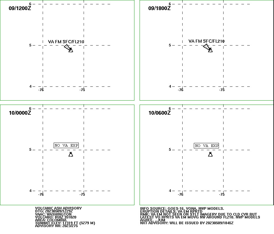
There is a three-hour-old ash advisory in effect right now:
FVXX22 KNES 091229
VA ADVISORY
DTG: 20230509/1229Z
VAAC: WASHINGTON
VOLCANO: RUIZ 351020
PSN: N0453 W07519
AREA: COLOMBIA
SUMMIT ELEV: 17319 FT (5279 M)
ADVISORY NR: 2023/275
INFO SOURCE: GOES-16. VONA. NWP MODELS.
ERUPTION DETAILS: VA EM RPRTD
OBS VA DTG: 09/1200Z
OBS VA CLD: SFC/FL210 N0501 W07525 – N0454 W07519
– N0452 W07519 – N0458 W07529 – N0501 W07525 MOV
NW 5KT
FCST VA CLD +6HR: 09/1800Z SFC/FL210 N0502 W07524
– N0453 W07519 – N0452 W07519 – N0458 W07529 –
N0502 W07524
FCST VA CLD +12HR: 10/0000Z NO VA EXP
FCST VA CLD +18HR: 10/0600Z NO VA EXP
RMK: VA EM NOT SEEN ON STLT IMAGERY DUE TO CLD
CVR BUT LATEST VO RPRTS VA EM MOVG NW AROUND
FL210. NWP MODELS AGREE. …KIM
NXT ADVISORY: WILL BE ISSUED BY 20230509/1845Z
Here is Jhon/VIDJCB’s morning video. As usual, he reads the SGC update, and the Google-Translated version is below:
From today’s SGC update, with emphasis by either SGC or me:
Yesterday, May 8, and so far today, the seismic activity related to the movement of fluids inside the volcanic conduits continues to predominate. This seismicity has presented a slight increase in the number of earthquakes and in the seismic energy released compared to May 7. Some of these signals have been related to pulsatile ash emissions, confirmed through the web cameras used for volcanic monitoring.
In addition, the seismicity record associated with rock fracturing inside the volcanic edifice continues, which showed a similar behavior in the number of earthquakes and in seismic energy compared to May 7. The earthquakes were located in the Arenas crater and scattered around it, at a maximum distance of 5 km and at depths between 1 and 6 km.
Regarding surface activity, the maximum height of the column of gases and/or ash observed was 1000 m measured from the top of the volcano and was related to an ash emission recorded on May 8 at 07:27 p.m. The preferential dispersion direction of the gas column was towards the west – southwest and northwest of the volcano. From satellite monitoring platforms, several significant thermal anomalies were observed at the bottom of the crater. On the other hand, the variations in the degassing of sulfur dioxide and the release of water vapor from the crater into the atmosphere are maintained.
These indicators confirm that the activity of the Nevado del Ruiz volcano continues to be very unstable and that it is necessary to continue with prevention measures. It is possible that the levels of seismic activity, as well as the levels of degassing or ash output, decrease or be oscillating, in the sense of increasing on some days and decreasing on others. However, this does not imply that the volcano has returned to its normal levels of activity, so it is recommended not to get used to these oscillating changes in activity and think that it is a normal activity of the volcano.
Therefore, we reiterate that the activity of the Nevado del Ruiz volcano continues at ORANGE LEVEL, which indicates that there is a probability that in days or weeks it will erupt more than it has in the last 10 years. To change the level and return to the yellow level, a prudential time is required where trends and patterns can be observed that allow us to infer the possible decrease in activity, aspects that the current activity of the volcano still does not show. For this reason, from the SGC we warn that the level of activity of the Nevado del Ruiz volcano will remain at ORANGE LEVEL for several weeks. During this time, in the event of an acceleration of processes suggesting an imminent eruption or the eruption itself occurring, the activity level will be changed to red.
We recommend that the community remain calm, follow all the instructions of the National Unit for Disaster Risk Management (UNGRD) and local authorities, and be attentive to the information provided by the Colombian Geological Service on the evolution of the state of the volcano.
The level of activity of the volcano remains at ORANGE LEVEL of activity or (II): PROBABLE ERUPTION IN TERMS OF DAYS OR WEEKS.
The COLOMBIAN GEOLOGICAL SERVICE will continue to be attentive to the evolution of the volcanic phenomenon and will inform opportunely about the changes that may occur.
For more information visit the following link:
https://www2.sgc.gov.co/Noticias/boletinesDocumentos/Forms/AllItems.aspx
In other news, the government reportedly (autotranslated) is expediting the licensing of four new AM/FM radio stations to transmit alerts and other vital information to high-risk communities (listed at that link).
There are plenty of warning/info stations already, of course, but not in the right places: the Andes terrain blocks radio and cell signals in some areas.
Featured image: Ric Photography/Shutterstock
