
- Hawaiian Volcano Observatory American Samoa page
- Global Volcanism Program (GVP) pages on Ta’u and Vailulu’u
December 11, 2025, 3:43 p.m., Pacific: I am updating old posts, including this one. However, things have been quiet since my last update. 🙂
October 6, 2022, 12:55 p.m., Pacific: The HVO has lowered Ta’u Island to Normal/Green status, although they are keeping a close watch on the seismic swarm and will issue reports once monthly or as needed.
September 24, 2022, 11:08 a.m., Pacific: The HVO has gone to weekly updates on Thursdays (and whenever needed in between), so I’ll unpin this post for now.
Per their September 22nd update, nothing has changed; the swarm continues and:
Analysis of the earthquakes in the swarm so far suggests that they occur north of Taʻū Island and the source of the earthquakes has not moved over time.
September 17, 2022, 2:18 p.m., Pacific: It’s still swarming, with some fluctuations, but that is all. The only new thing is that, on September 6th, the volcanologists wrote:
The current best estimate of earthquake location is approximately 5-15 km (3-9.3 mi) off the northern shore of Ta‘ū Island at about 10-15 km (6-10 mi) below the surface. Ocean water depths north of the island are greater than 1 km (0.6 mi) at 5 km (3 mi) offshore and 3 km (1.8 mi) at 15 km (9.3 mi) offshore. Seismologists have determined that earthquakes occur in a fixed position within the earth. So, although there is difficulty in resolving the exact location within the earth’s crust, the earthquakes have not been moving from that spot.
I would ordinarily guess that this was a dike of some sort, emanating from the nearby hotspot, but that probably would show movement — either the dike itself or the associated fluids and gases.
Who can tell what it is at this point?
September 2, 2022, 8:05 a.m., Pacific: From today’s update:
…Preliminary data analysis suggests a wide area of possible earthquake locations extending from deep beneath Ta’u Island to shallower depths about 10 km (6 mi) to the north. The source of the earthquakes has not moved within the earth since monitoring began 3 weeks ago – the source position has remained constant. Seismologists continue to examine data and refine locations….
Just guessing here: a dike intruding from the nearby hotspot (which isn’t a single point, of course — look how Kilauea and Mauna Loa perk along despite that hotspot currently being under the Seamount Formerly Known As Loihi)?
Time will tell, hopefully without an eruption or slide of any sort.
August 31, 2022, 2:56 p.m., Pacific: No changes, but the USGS just tweeted out some information — please read the whole thread:
Seismic data now available online! Go to Ta'u Island webpage https://t.co/Q3WOg7osKB and click on the top green button (upper right on map) to see options. Under Instruments, you will find station TAU, FAGA and OFU. Click on a station to see real-time data, like this screen grab. pic.twitter.com/dL6m47594X
— USGS Volcanoes🌋 (@USGSVolcanoes) August 31, 2022
https://platform.twitter.com/widgets.js
August 30, 2022, 12:34 p.m., Pacific: There’s no change. The volcanologists are working to improve their monitoring network as much as possible.
Here are:
- All the updates, at least through today (18 to date).
- Seismic data the boffins have shared online (actually, the network appears to be down at present, but it’s likely to come back up).
August 23, 2022, 9:56 p.m., Pacific: No changes, per today’s update, except that the number of earthquakes may have increased slightly over the last 48 hours.
That’s hard to say, though, because they may have missed some, given the new installation and limited network coverage.
These islands above the waves are so much smaller than those in the Hawaiian chain. Unfortunately, seismologists can’t just snorkel on down there and install a complete network on each gigantic submarine structure.
August 22, 2022, 3:35 p.m., Pacific: Looks like they are starting daily updates from American Samoa now. Here is today’s:
HAWAIIAN VOLCANO OBSERVATORY DAILY UPDATE
U.S. Geological Survey
Sunday, August 21, 2022, 2:57 PM HST (Monday, August 22, 2022, 00:57 UTC)TA’U ISLAND (VNUM #244001)
14°13’48” S 169°27’14” W, Summit Elevation 3054 ft (931 m)
Current Volcano Alert Level: ADVISORY
Current Aviation Color Code: YELLOWThere has been no significant change to the earthquake activity beneath or around Ta’ū and Ofu-Olosega Islands since yesterday’s update. USGS staff have identified sites on Ta’ū Island where advanced seismometers will be installed in the coming days. On August 20, USGS staff gave a briefing to the Governor, Lieutenant Governor, members of the cabinet, and other officials at the Governor’s Special Meeting. The USGS briefing covered USGS information products, alert level and aviation color codes, scenarios, and hazards.
Over the past several days approximately 20 earthquakes per hour have been recorded. Though the exact count isn’t available, the number of recorded earthquakes in the past 24 hours appears slightly lower. The estimated size of the largest earthquakes is between magnitude 2 and 3. Preliminary estimates place the earthquake source closer to Ta’u Island than Ofu-Olosega. Reports of booming sounds on August 20 and the morning of 21 are being investigated.
USGS scientists are monitoring the earthquakes with microseismometers (small and basic earthquake detectors) placed on Tutuila, Ta’ū, and Ofu-Olosega Islands. Larger, more sophisticated, and accurate seismometers are being installed in the coming week. Data from the new equipment will help to accurately locate the earthquakes and develop better assessments of possible future hazards.
Samoan and English language alert level and color code definitions: (PDF download, 57.68 kb) https://d9-wret.s3.us-west-2.amazonaws.com/assets/palladium/production/s3fs-public/media/files/VOLCANO%20AVIATION%20CODES%20AND%20ALERT%20LEVELS.pdf
This notice contains volcanoes not displayed here: Ofu-Olosega (ADVISORY/YELLOW).
The Hawaiian Volcano Observatory is one of five volcano observatories within the U.S. Geological Survey and is responsible for monitoring volcanoes and earthquakes in Hawaiʻi and American Samoa.
CONTACT INFORMATION:
HVO, askHVO@usgs.gov—best contact for regular reporting and questions.
Ken Hon, HVO Scientist in Charge, USGS khon@usgs.gov
Natalia Deligne, American Samoa Lead Responding Scientist, USGS ndeligne@usgs.govSubscribe to these messages: https://volcanoes.usgs.gov/vns2/
Summary of volcanic hazards from eruptions: https://www.usgs.gov/observatories/hvo/hazards
Recent earthquakes in Hawaiʻi (map and list): https://www.usgs.gov/observatories/hvo
Volcanoes of American Samoa: https://www.usgs.gov/observatories/hvo/volcanoes-american-samoa
Explanation of Volcano Alert Levels and Aviation Color Codes: https://www.usgs.gov/programs/VHP/volcanic-alert-levels-characterize-conditions-us-volcanoes
They have also put this seismic data online via Raspberry Shake (note: it does go offline sometimes; this is new field work, after all — not yet a well-established network like those at some other monitored US volcano).
Also, here is the Alaska Volcano Observatory’s page on webicorders and the National Weather Service forecast to help us weed out the effects of weather and waves.
The online data actually is intended for scientists around the world, not for us laypeople, but it’s kind of cool to watch.
I don’t imagine these quakes are much fun for the local people, though!
Update, August 19, 2022, 4 p.m., Pacific: No changes, but the volcanologists have seen enough to report on the 18th:
The earthquake swarm is most likely due to magma movement beneath the volcanoes and not tectonic faulting.
That was the big initial question, since huge basaltic structures are involved: Was it magma breaking rocks and causing earthquakes or was it tectonic, i.e., stressed rocks fracturing, perhaps getting ready to fail in an undersea landslide of some sort?
So, yay!
But what’s up with the magma? That is not yet clear, per the rest of that report, which HVO published in their newsletter Volcano Watch.
Hope they can send out a submersible to see if there is new vent activity between Vailulu’u and Ta’u.
Update, August 15, 2022, 8:47 a.m., Pacific: No changes, per today’s update.
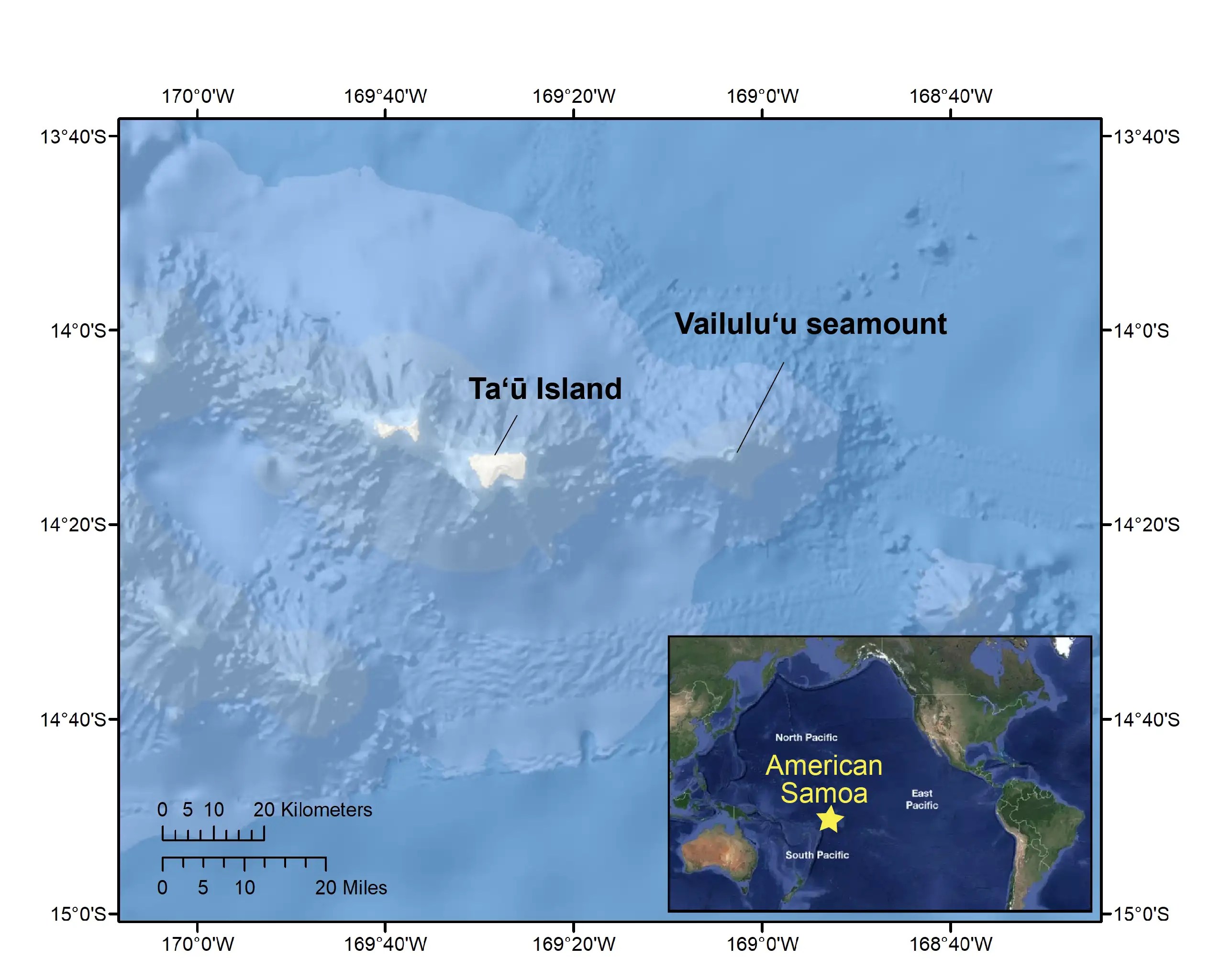
They’re putting in more equipment, and are detecting 30-60 quakes an hour at present. The quakes seem to be closer to Ta’ū Island than to the volcano sitting over the hotspot, Vailulu’u, which is interesting.
It’s amazing to see how many agencies are cooperating in this effort, including the Alaska Volcano Observatory as well as HVO, local National Weather Service offices as well as the Pacific Tsunami Center, and even Kiwi volcanological observers.
Probably that’s partly because this site is waaaay out there in the blue latitudes, far from the usual monitoring sources, and a joint operation is necessary (and organized amazingly quickly!)
Also, perhaps, <layperson speculation> it’s because this is a special area of interest. I’ve been doing a little reading (very little, since I’m trying to get this DV eBook revision done ASAP) and have developed a few very vague and ?interconnected? ideas.
Take them FWIW (probably not very much):
- It turns out the Samoan islands are adjacent to — but not, I think, connected to — the northern end of the Tonga Trench subduction zone.
Again, these are totally different from Tongan volcanoes, more Hawaiian style than explosive, but it’s a more complex setting than in Hawaii.
- The Tonga subduction trench is connected to the Kermadec subduction trench farther south: indeed, the boffins sometimes call this the Tonga-Kermadec Trench.
- If “Kermadec” sounds familiar, it might be because this is where there have been a few massive quakes in recent years.
- The tectonic picture here is insanely complicated but awesome — as I understand some of the main action, subduction at the Tonga-Kermadec trench is helping to bring Australia northward, where hundreds of millions of years from now, it will collide with Eurasia as a new supercontinent comes together.
This sort of thing is going on elsewhere, too (Africa –> Eurasia, for instance), but the geologically recent big Kermadec Islands earthquakes might signify some sort of ongoing step in this Pacific Plate tectonic process, and Earth processes are too big to ignore as well as extremely challenging even for PhDs to understand.
- We just saw a surprisingly massive blast north of the Kermadec trench at Hunga Tonga. That has been plausibly explained by typical volcanic processes, and it very well could be unrelated to everything else, but it’s an item of interest.
- Now, north of the Tonga trench and separate from it AFAIK but close by, and near but apparently not over a hotspot, some unusual seismicity has begun.
Sure. This complicated business is going to draw international interest from a variety of earth science fields, not because it’s any more of an increased risk to local stakeholders than any other active volcanic complex (nor any less), but because the Earth seems to be up to something new here and, I suspect, no one yet knows what it might be.
Original post:
That’s a public-domain image from the US Geological Survey, showing a lava dome that was detected in the submarine volcano Vailulu’u, in American Samoa, earlier this century.
Vailulu’u sits atop an active hotspot, and the dome has gotten larger since then.
However, that’s not why Vailulu’u is in the news today.
Because of a recent earthquake swarm, the Hawaiian Volcano Observatory issued a statement, August 13th, on it and nearby Ta’ū Island (post continues below this text):
USGS HVO — Ta’ū Island Information Statement Regarding Felt Earthquakes in American Samoa: August 12, 2022
By Ta’ū Island
August 13, 2022
An earthquake swarm is occurring in the Manu’a islands of American Samoa. These earthquakes are most likely related to either Ta’ū volcano or the nearby submarine Vailulu’u volcano. Experts continue to assess the situation.
Summary
Residents of the Manu’a group of islands in American Samoa continue to feel earthquakes. Reports from National Park of American Samoa staff and Ta’ū residents suggest that the activity began on July 26th. Since August 10th, earthquakes have also been reported by residents of Ofu and Olosega islands.
Reports suggest that the earthquakes vary in intensity, but are generally short, sharp jolts. The earthquakes are more likely to be felt by people indoors at rest and along the coast, where buildings sit on sediment that amplifies shaking. These factors are probably responsible for the variability in reporting.
Based on the reports, these earthquakes are probably related to either Ta’ū or Vailulu’u volcanoes.
Scientists are investigating earthquakes and unconfirmed reports of other activity. Several residents of Ta’ū reported loud booming noises on Wednesday night, August 10; no other noises have been reported since then.
Scientists plan to install additional instruments to monitor earthquakes and other activity in the coming week.
Analysis
The earthquake activity reported to date suggests a local volcanic source.
Due to limited earthquake monitoring equipment, the exact location of these earthquakes is currently unknown.
Not all earthquake swarms result in eruptions. Current low-level earthquake activity may continue and vary in intensity for days to months without an eruption. It is also possible that the swarm is an early precursor to an eventual eruption. At this time, we cannot determine which of these possibilities is more likely.
Volcanoes in American Samoa are similar to those in Hawaii. If activity escalates to an eruption, it will most likely include slow-moving lava flows or low-level explosions of lava that are localized to a small area. An eruption like Hunga Tonga–Hunga Ha’apai in Tonga earlier this year is extremely unlikely as it is a different type of volcano. Volcanoes in Tonga erupt much more explosively than ones in American Samoa and Hawaii.
Response
Experts at the Pago Pago National Weather Service Office, USGS Volcano Hazards Program, NOAA Pacific Tsunami Warning Center, NOAA-IOC International Tsunami Information Center, and USGS National Earthquake Information Center are working together with the American Samoa EOC to understand the source of these earthquakes better. The Samoa Meteorological Service is also reporting increased seismicity south or east of Tutuila Island.
Dr. Natalia Deligne of the US Geological Survey Hawaiian Volcano Observatory (HVO) arrived on August 11 in Pago Pago and is consulting with local authorities on the situation. Additional HVO personnel and earthquake detection instruments are expected to arrive in American Samoa next week. Dr. Charles McCreery, Director of the Pacific Tsunami Warning Center, will arrive next Monday to advise tsunami concerns.
Currently, American Samoa’s volcanoes are monitored remotely by satellites and a distant seismic (earthquake detection) station in Apia, Samoa. These instruments might detect significant explosive activity in American Samoa, but the lack of ground-based monitoring stations at the volcanoes does not allow for advanced warning of new activity. With the existing real-time earthquake-monitoring network in American Samoa, the earthquakes’ locations and magnitudes cannot be precisely determined. HVO scientists plan to install additional earthquake monitoring instruments in the coming weeks.
Residents can significantly assist these monitoring efforts by noting and reporting accurate times that they feel earthquake shaking to either the National Weather Service Office (https://www.weather.gov/ppg/wsopagooffice) or American Samoa EOC in Pago Pago (684-699-3800).
HVO will issue another information statement on Monday, August 15. Additional messages may be issued as needed.
Background
Ta’ū is a shield volcano with rift zones to the northeast and northwest; the last eruption of Ta’ū occurred in 1866 as a submarine cone that formed between Ta’ū and Ofu-Olosega islands.
Vailulu’u is a submarine seamount whose summit is about 1970 feet (600 m) below sea level. The last eruption of Vailulu’u was in 2003, during which a cone formed within the summit caldera.
Hazards
It is unclear if this unrest will escalate to a volcanic eruption. Volcanic hazards associated with eruptions in American Samoa could include volcanic gases, low-level explosions of lava localized to a small area, lava flows, earthquake shaking, and tsunami.
Information about these hazards, which are similar to those in Hawaii, can be found at this HVO website: https://www.usgs.gov/observatories/hvo/hazards.
A submarine volcanic eruption or landslide can generate a tsunami. The Pacific Tsunami Warning Center will issue a warning if they detect earthquake activity that is likely to cause a tsunami. However, volcanic eruptions do not usually generate large enough earthquakes to warrant a tsunami warning. If there is a tsunami from a nearby volcanic eruption, residents of the Manu’a islands and elsewhere in American Samoa are more likely to experience natural warning signs before receiving an official tsunami warning.
If you are at the coast, heed the natural tsunami warning signs. If you feel a strong or long-duration earthquake, see a sudden rise or fall of the ocean, hear a loud roar from the ocean, or see a large aerial plume from an eruption, a tsunami may follow, and you should immediately move to higher ground.
Here is information on what you can do to protect yourself and your family if you see a tsunami or receive a warning: https://www.weather.gov/safety/tsunami-during.
Additional information will be provided as it becomes available.
Earlier this year, the Volcano Hotspot blog included these two volcanoes in part 2 of their look at American Samoa volcanoes.
And here is a teaching outline with links, if you’re curious about how these hotspot islands compare to the Hawaiian Islands.
That’s theoretical to some extent; the realities of Samoan volcanism are more complex (jargon alert).
More information:
Vailulu’u:
- GVP
- Eel City and the Moat of Death: NOAA expedition, 2005.
Here is a video segment from a more recent dive, just a few years ago — “Bubbles! We have bubbles!”
- Vailulu’u Undersea Volcano, Hart et al., 2001
Ta’ū:
- GVP
- Wikipedia on Ta’ū Island
- What the place looks like. I had never really looked into these islands before.
Ta’ū apparently has gone off the grid:
And here is someone with my level of camera skill — not a professional videographer, IOW — who is using different cameras to record some flights between Ta’ū and Tutuila (which has its own GVP page and is mentioned briefly in the HVO information statement):
All in all, this looks like a really nice place for people and those weirdly beautiful sea creatures. I hope they don’t get hit with an eruption.
