
It began around 1:18 p.m. on August 3rd, per the Iceland Met Office (Icelandic).
Per Google Translate:
Post published at 1350
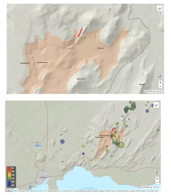
A volcanic eruption has started in the western part of Merardálar about 1.5 km north of Stóra-Hrút, and the ground fire appears to be coming from a northeast-southwest crack at that location. At first inspection of web cameras, magma appears to have surfaced at 1:18 p.m.
Based on the first pictures taken by Halldór Björnsson of the Icelandic Meteorological Office from a surveillance flight with the Norwegian Coast Guard, the crack is located at the northern edge of the new lava that emerged in the last eruption.
The crack appears to be about 300 m long based on the first measurements.
A map showing the rough location of the crack based on the first images. The fissure is located on the northern edge of the lava that formed in the eruption that began in March last year.
In an update about five hours later, they report that the eruption isn’t likely to threaten important infrastructure.
Visiting the site is risky, though.
Gas pollution at the fountains and not an easy walk
The National Weather Service points out that, like last year’s eruption, this eruption is accompanied by considerable gas pollution. It was stated in RÚV’s interview with Hjálmar Hallgrímsson of the police in Suðurnes that the area near the eruptions has not been closed, but he says that the hiking trail to the new fissure is very difficult. “There is a certain part of the area, the old lava, which we believe is quite certain and people want to see it. We think it’s OK – but to walk in completely after the new eruption is a very long and difficult path and it’s not for everyone to go that way.”
The Norwegian Meteorological Agency is now working on publishing gas distribution forecasts again on the vedur.is website.
Quick update: Just found this view of the eruption from near Reykjavik:
Featured image: Halldór Björnsson/IMO
