
Also, as of October 7:
October 25, 2021, 9:23 p.m., Pacific: The volcano emitted almost 54,000 tonnes of SO2 yesterday. Am only a layperson, but that suggests to me a huge amount of recharging magma. As it erupts, it appears to be shouldering weaker parts of the cone aside.
This was tweeted about an hour ago:
Se ha abierto una nueva boca en el flanco del volcán. Vídeo registrado a las 14.45 (hora canaria) / A new vent has opened in the volcano’s flank. Video registered at 2.45 pm (Canarian hour) pic.twitter.com/zeqy92KW0p
— INVOLCAN (@involcan) October 25, 2021
https://platform.twitter.com/widgets.js
There are at least six active openings in the cone now.
My stalkers, unfortunately, are apparently messing with my HTML coding again, so I will start a new post for events from October 25 on. (Yes, I know it’s illegal, but I find it challenging to shut down a malicious birth family that apparently has some connections in the law enforcement/military “good ole boy” network: seemingly deniable stalking, but this victim is working on an effective defense. Takes time, though. 🙂 )
October 24, 2021, 9 p.m., Pacific: Per El Mundo, via browser translator and me:
20.55. NEW LAVA FRONTS TEST THE VOLCANO’S VIGOR FIVE WEEKS LATER
Far from abating, the volcano of La Palma has reached five weeks of eruption at full power in a day in which it has added a new flow and an open vent under the secondary cone from which abundant liquid lava flows, and in which earthquakes have been constant.
Carmen López,head of the volcanic surveillance network of the National Geographic Institute (IGN), tells Efe that it is still too early to know how this new emission center will behave in the future, if it will form a new cone or if it will be a lava vent like others opened previously, through which more liquid lava comes out.
That makes it advance downhill with greater speed above pre-existing castings.
López indicates that an increase in the tremor signal has been observed this Sunday until reaching a climax that coincides with the appearance of this new emitting center, and from there it has decreased significantly.
There has also been a considerable increase in seismicity and explosiveness in recent hours, with several sonic booms, until the opening of the new hole in the volcanic cone in Cumbre Vieja.
Thermal views of the cone are awesome:
Video infrarrojo de la actividad a última hora de hoy tras un día de gran actividad en el volcán / Infrared video of late night activity after a verte active day at the volcano pic.twitter.com/XmCswSQY61
— INVOLCAN (@involcan) October 24, 2021
https://platform.twitter.com/widgets.js
That was tweeted about five hours ago and presumably recorded by this person:
Buscando nuevos emplazamientos para realizar termografía, a las 20:30 hora canaria / Looking for new locations to perform thermography, at 20:30 canarian time pic.twitter.com/GgRBzGsqBh
— INVOLCAN (@involcan) October 24, 2021
https://platform.twitter.com/widgets.js
October 24, 2021, 10:07 a.m., Pacific: I don’t have the time today to get deeply into this, but from what I’ve read, this eruption is far from over.
The cone has had major shape changes twice since the last post; experts quoted in El Mundo say that’s because magma supply is shifting around. There also is word that seismicity increase and its patterns suggest the magma plumbing system may be recharging — not good news.
This is how the volcano, located inside El Paso, La Palma, city limits, looked about ten hours ago:
Fotografía de la erupción a las 8.45 (hora canaria) tomada por nuestro colaborador @RafaAvero / Picture of the eruption at 8.45 a.m. (Canarian hour) taken by our collaborator @RafaAvero #lapalma pic.twitter.com/3naCwsjiSt
— INVOLCAN (@involcan) October 24, 2021
https://platform.twitter.com/widgets.js
October 19, 2021, 12:01 p.m., Pacific:
My translation: Today the eruption is 30 days old. It has already surpassed the 1971 Teneguía eruption (25 days) and we’re on track to surpass the 1949 San Juan eruption (42 days).
Hoy se cumplen 30 días de la erupción de La Palma. Ya hemos sobrepasado la duración de la erupción del Teneguía (25 días, 1971) y vamos camino de superar la del San Juan (42 días, 1949). pic.twitter.com/I4TMBq2lnG
— 🏳️🌈Rubén López 🇪🇸 (@rubenlodi) October 19, 2021
https://platform.twitter.com/widgets.js
There are also some amazing tweets out there today, including this one, which shows the three active vents on this huge structure:
Ecco un video girato nel tardo pomeriggio di ieri sull’isola di #LaPalma. Da esso si possono osservare ancora meglio le tre bocche principali attualmente attive: una emette soltanto ceneri e lapilli, una peoduce fontane di lava e l’altra alimenta le colate laviche. pic.twitter.com/jBXbQaqT2Y
— Il Mondo dei Terremoti (@mondoterremoti) October 19, 2021
https://platform.twitter.com/widgets.js
There is also a fourth vent — the reactivated fissure vent that caused so much excitement the other day. The volcano spotters included it on this cool cross-sectional diagram today:
Infografía para comprender mejor como funciona el edificio volcánico de la erupción de La Palma. Escala aproximativa con finalidad divulgadora a 18.10.21. @112canarias @CabLaPalma @Marianohzapata #ErupcionLaPalma #VigilanciaLaPalma #volcanesdecanarias pic.twitter.com/IxhBLWMdCo
— Volcanes de Canarias (@VolcansCanarias) October 19, 2021
https://platform.twitter.com/widgets.js
The eruption is going full bore currently, by all reports, but it paused briefly last night, per El Mundo. If this keeps up, maybe it’s a sign that the end is approaching.
Also El Mundo quoted the IGN Canaries director as saying today that SO2 levels have decreased lately, though not enough yet to be a sign of decreasing underground magma recharge.
And reportedly (Spanish) there is slight deflation of places away from the eruption.
Hope it isn’t going to last much longer. Eruptions are always dramatic, but they’re not fun to watch when they happen around and to people.
This is from the Kilauea 2018 eruption:
I wanted to share a pair of images with you:
1. Kapoho Cemetery photo from wikipedia
2. My photo from 2021This original photo is something that has stuck with me. It speaks to how even if we evacuate everyone there are always important things and places left behind. pic.twitter.com/eOSYB2E0bp
— Anna Perttu (@InfraSaurus) October 19, 2021
https://platform.twitter.com/widgets.js
La Palma’s climate is different from Hawaii’s, and it will take much longer for the green to return here.
#volcánLaPalma🌋 Este 19 de Octubre se cumple un mes del inicio de la erupción en #LaPalma. Una erupción que aún no tiene indicios de tener un final
En este vídeo hemos recopilado las imágenes que durante estos treinta días ha dejado el volcán#FuerzaLaPalma pic.twitter.com/fK0thkab6X
— RTVC (@RTVCes) October 19, 2021
https://platform.twitter.com/widgets.js
This is also a slightly edited TalkWeather post
October 16, 2021, 9:12 a.m., Pacific: Per El Mundo’s coverage of today’s PEVOLCA press conference, yesterday’s “new” vent was actually reactivation of one of the old vents along the initial fissure lines. It’s expected to vent nothing but tephra: this layperson thinks that means gas flow as at the start (gas content is what drives lava fountains), but they’ve probably not detected any magma underneath that part of the erupting fissure system.
The rest of the report is about lava flows, but this caught my eye (per browser translator):
Currently there is a high probability of earthquakes above magnitude 4.5 and in the last hours there have been about 30 earthquakes, with a maximum magnitude of 4.6…
9.35. TWO EARTHQUAKES OF 4.5 AND 4.6 SHAKE LA PALMA DURING THE NIGHT
The 24-hour monitoring volcanic monitoring network of the National Geographic Institute (IGN) has located during the night a total of 37 earthquakes associated with the eruption of the Cumbre Vieja volcano,two of them of magnitudes greater than 4 (mbLg).
The maximum magnitude recorded was 4.6 (mbLg) corresponding to the earthquake located southwest of the municipality of Villa de Mazo at 05.41 hours. With intensity III-IV EMS and a depth of 37 km, it was felt in numerous nuclei throughout the island. This is the largest earthquake to date.
This tremor was followed an hour later (07.07 hours) by another earthquake of 4.5 (mbLg), also southwest of Mazo, with intensity IV-V and a depth of 37 km. Like the previous one, it was felt in practically all the municipalities of the island.
Yesterday 83 earthquakes were located, the largest of 4.5 mbLg, located southwest of the municipality of Villa de Mazo at 08.02 hours. With intensity III-IV EMS and a depth of 36 km, this tremor was also felt on almost the entire island of La Palma. Europa Press reports.
The last M4-something shows on the IGN Twitter feed about two hours ago, an M4.3, at the deep focus.
IGN did tweet (it’s linked earlier in the thread) that they felt at that point that the island was adjusting to the eruption. That’s going to rock the casbah a bit in something this big, and it would even conceivably cause fissure movement like that I saw in the cam and described here (and which opened up the old vent yesterday, I think, per Itahiza’s “fissure” comment above).
Why? Because this whole thing started at the southern tip of the island and moved north — and now there is that big caldera structure standing in the way, plus the rest of the northern volcanic edifice, neither of which seem particularly movable.
I don’t understand, though, why the eruption became more ashy and explosive as that deeper focus showed up — a trend that’s increasing (ash has shut down flights to La Palma again, don’t know about the other islands); why the quakes only have two foci, if the whole island is adjusting; what’s happening with the fissure system. Well, there’s a lot I don’t understand, which is nothing new. 🙂
Am guessing, though, that the old caldera and the northern edifice are really in tectonic control of this business. The big unknown may be how much eruptible magma is down there to continue providing an irresistible force against that “immovable object.”
The really good news is that reportedly there continues to be almost no seismicity at the surface. That “worst-case” scenario was debunked, but “minimal risk” does not equal “no risk.” Landslides start at the top, thougn, and there appears to be no sign of trouble there, per reports.
October 15, 2021, 12:39 p.m., Pacific: Yesterday there was what INVOLCAN called a “tsunami” of lava.
Right now, developing in the last hour, there is what looks to lay eyes like a plinian-style column rising from a new vent southeast of the Cabeza de Vaca cone.
Video donde Ramón Casillas, miembro debla ULL en #PEVOLCA, confirma la nueva boca al Sureste del volcán actual. @112canarias @CabLaPalma @Marianohzapata #ErupcionLaPalma #VigilanciaLaPalma #volcanesdecanarias pic.twitter.com/s4091IacVF
— Volcanes de Canarias (@VolcansCanarias) October 15, 2021
https://platform.twitter.com/widgets.js
Since 19.12 pm a notable sustained eruptive with an umbrella-like ash cloud (still expanding) is observed at #CumbreViejaVolcano. @Involcan has indicated a new vent has formed SE from the main vent.
📷Observatorio Roque de Los Muchachos.#erupciondelapalma #LaPalmaVolcano pic.twitter.com/sklsM2XGOo— Jorge Eduardo Romero Moyano (@jeromerovolcan) October 15, 2021
https://platform.twitter.com/widgets.js
More on this as it develops and gets on the Net.
1:05 p.m., Pacific: These recent “spotter” pics are reassuring. That hill isn’t in the stratosphere, and the eruption column is interacting with winds rather than blasting through them as a Plinian column would.
Interacción con la atmósfera de columna eruptiva captada hoy al anochecer desde altos de Adeje, Tenerife por #RobertoMelo @mi_vida_autentica @112canarias @CabLaPalma @Marianohzapata #ErupcionLaPalma #VigilanciaLaPalma #volcanesdecanarias pic.twitter.com/vvKAqA39QS
— Volcanes de Canarias (@VolcansCanarias) October 15, 2021
https://platform.twitter.com/widgets.js
Of note, there was another deep-focus M4.5 quake a couple hours before this new eruption behavior. Contrast that with the days that passed between last Friday’s deep-focus quake and yesterday’s lava “tsunami.”
Will wait for word on all this from official sources.
October 13, 2021, 6:49 a.m., Pacific: Here’s a cool but depressing visualization of the flows as of the 11th. That northern flow has eaten more infrastructure since then and forced hundreds more people to evacuate.
[11/10/2021] He mejorado bastante el vuelo #3D y ahora muestra la isla completa, y las 6 últimas coladas juntas (días 6 al 11).
Con datos del @CabLaPalma sobre un mapa del @IGNSpain.@lapalmaopendata @InnovaLaPalma #VigilanciaLaPalma #LaPalma #ErupciónLaPalma #VolcandeLaPalma pic.twitter.com/3xLFCqIqCY
— Pedro Suárez 🔗 x-y.es (@x_y_es) October 12, 2021
https://platform.twitter.com/widgets.js
Per an official statement on the 12th, via Google Translate:
……
Preliminary chemical analyzes and visual inspection of the different lava flows and pyroclasts show a temporal evolution of the magma from more differentiated to more primitive terms along the baseite-tephrite magmatic series. This evolution is common in historical eruptions on La Palma.
The main flow of lava flows runs along the north flank, down the northern part of the previous flows, following trajectories towards the west and northwest, within the exclusion zone. The distance from the front of this lava flow to the sea is of the order of 200 m, but with a very slow advance. Large blocks carried by lava flow further north are still observed, although less frequently. The emission centers of the crater are still active and the appearance of new emission centers in the vicinity of the main cone, as well as other surface observables (visible gas emissions) within the exclusion zone, is not ruled out. The lava field that fed the lava delta (fajana) of the beaches of Los Guirres seems to have no activity, as well as the lava flow that runs over the lava delta of 1949 in the El Charcón area. The absence of activity in the lava delta seems to be corroborated by underwater videos and close range sea pH and temperature data.
The morphology of the cone changes repeatedly due to the successive processes of growth and reconfiguration. The eruptive process can show episodes of increased and decreased strombolian activity, as well as pulses with phreatomagmatic activity.
…
Seismicity continues to be located, mainly, close to the seismicity of the first days, at depths between 10 and 15 km. There are also earthquakes located at depths greater than 20 km. In the last 24 h the amplitude of the tremor signal has increased. The maximum magnitude observed was 4.1 mbLg and the maximum intensity was IV EMS. The current level of seismicity continues to indicate that more felt earthquakes are possible, which could cause small landslides in sloping areas. The deformations at the stations closest to the eruptive center do not show any significant pattern.
During yesterday (10/11), the emission of sulfur dioxide (SO2) associated with the volcanic plume (visible emanations) continues to register high values and in line with the eruptive process, reaching values of 21,868 tons per day (underestimated value). … All these geochemical observations are consistent with the current eruptive process….
To this lay volcanophile, that increase in SO2, especially in light of the ongoing deeper-focus seismicity, suggests input of fresh magma from below and no end to the eruption any time soon.
Oh, per some news tweet I read yesterday, they’re still trying to come up with an official name for this cone. “Cabeza de Vaca” (Cow’s Head) on that tweet below apparently was just a nickname.
This effusive eruption is even producing some volcanic lightning!
14.30h | 🔴 Vídeo que captura los rayos volcánicos de las últimas jornadas.
🔸 Es un fenómeno totalmente normal y que responde a la fricción de los fragmentos de roca que expulsa el volcán.
📹: @IGNSpain#RTVCconLaPalma pic.twitter.com/IIJvkrGPoL
— Canarias Radio (@laautonomica) October 13, 2021
https://platform.twitter.com/widgets.js
October 11, 2021, 7:52 a.m., Pacific: The lava flows continue and about three thousand people, at last report, are confined to their homes downwind of a cement factory the lava is now burning through.
Per El Mundo, via browser translator,
An earthquake of magnitude 4.3 shook the island of La Palma last night at 22.46 hours, with epicenter in the municipality of Villa de Mazo and focus at very deep levels, 39 kilometers from the surface. Since that earthquake, another 40 earthquakes have been recorded in La Palma,all with epicenters in the municipalities of Villa de Mazo and Fuencaliente and foci at medium or high depths.
RTVC interviewed an IGN expert:
“Lo que vemos ahora mismo s una desestabilización de la isla porque tenemos un proceso eruptivo en la superficie y se tiene que ajustar todo ese material preexistente”
Explica @stavrosmel de @ignspain sobre la sismicidad en #LaPalma #RTVCconLaPalma #ErupcionLaPalma pic.twitter.com/GfMxUPmc17
— RTVC (@RTVCes) October 10, 2021
https://platform.twitter.com/widgets.js
Per Google Translate:
What we see right now is a destabilization of the island because we have an eruptive process on the surface and all that pre-existing material has to be adjusted.
I have also seen a tweet from volcanologist Boris Behncke noting that they sometimes note deep seismicity at Etna when lava is erupting quickly and the conduit/edifice adjusts to those changes.
Thing is, ocean crust is reportedly only 15 km or so thick under the Canaries. How can those deep-focus quakes be directly related to the Cumbre Vieja edifice?
Indirectly, maybe. I looked up papers recently about the volcanic plumbing here and learned only that it is insanely complex. There seems to be a history of basalt underplating here.
This layperson is guessing that the magma has somehow worked its way through that mess — which must be very difficult for scientists to “see” through using indirect methods — and has opened a channel to the surface. Petrology will eventually show whether the mantle or a deep, long-lived magma chamber is feeding through that channel.
8:25 a.m., Pacific: So I got back on Twitter and saw this new tweet from someone knowledgeable:
Hoy hace un mes que comenzó la actividad precursora de la erupción de #LaPalma con la intrusión a 11 km bajo la isla. Realmente el 12 ya se puso la cosa seria.
Y ya 4 años antes veníamos detectando en el @IGNSpain sismicidad donde se almacenó el magma a 25-35 km de profundidad pic.twitter.com/ZX0nTff2oo— Itahiza (@ita_dc) October 11, 2021
https://platform.twitter.com/widgets.js
Per Google Translate:
Today, a month ago, the precursor activity of the #LaPalma eruption began with the intrusion 11 km below the island. Really the 12 already got the serious thing.
And 4 years before we had been detecting in the@IGNSpain seismicity where magma was stored 25-35 km deep.
Well, the chamber or chambers are that far down. So, why the uptick in seismicity down there now that there is an open channel to flow through (and, per the last report I saw, a few days ago, no increased ground deformation at the surface)?
October 10, 8:58 a.m., Pacific: The graphics on this tweet sum up the situation nicely. Seismicity remains high, with most quakes coming from the location and depth range of the original swarm, and a respectable number coming from a deeper source.
10oct2021 #NacionalDSN🇪🇸 #LaPalma #PEVOLCA #ErupcionLaPalma #VolcanLaPalma @CopernicusEMS @CabLaPalma @mitmagob @interiorgob @aena @112canarias @proteccioncivil @UMEgob @DGTes @CopernicusEU @DronSea @PresiCan ➡️https://t.co/kUGIkp0IK0 @IGNSpain ➡️https://t.co/pw8fH2BcBW pic.twitter.com/jbe5GaDIbC
— DSN (@dsn) October 10, 2021
https://platform.twitter.com/widgets.js
The notice says that the cone’s northern flank collapsed after a crack opened up in it Friday. The new flow is going through evacuated areas.
And yes, the collapse was impressive, although not explosive, fortunately for bystanders:
https://youtu.be/nQ-r8U32xkU&rel=0
The notice also says that there is more concern over the southern flow — the main one.
This volcano shows no signs of slowing up, as far as I can see. ☹
Here’s a drone view of the new flow from IGME, tweeted about 7 hours ago. Remember, this is the flow they’re LESS concerned about!
https://youtu.be/SJ0G8JiS8yk&rel=0
Meanwhile, on the southern side, lava tubes are now channeling flows which reach the coast quickly, enlarging the new lava deltas. Those may break off when they reach the island’s shelf and tumble down to the Atlantic abyssal plain. If and when it happens, that will be very explosive (lava + water = BOOM!).
Also, per El Mundo’s coverage of today’s PEVOLCA press conference, one of the southern lava flows isn’t moving but just thickening.
When whatever is damming it gives way, there will likely be a flood.
This is also a TalkWeather post, though I’ve added some Twitter views of the divergent lava stream.
October 7, 2021, 10:07 a.m., Pacific: That decades-old worst-case megatsunami paper and the public concern it engenders make this difficult to talk about, but the seismicity swarm continues.
Per El Mundo today at 17:45 (via browser translator — their emphasis but I added a link so you can see the official reports as they go out; there are more than what’s mentioned here):
The National Geographic Institute has recorded an earthquake of a magnitude of 3.8 southwest of the Villa de Mazo, on the island of La Palma,37 kilometers deep, according to reports.
The movement has occurred at 15.26 Canarian time and has been felt by the population, says the IGN in a statement.
This Thursday there have been other tremors in the same area, one of 4.3 also in the southwest of Villa de Mazo, 35 kilometers deep, registered at 12:17 pm, also felt by the population.
This earthquake has been followed by three others of magnitude 3.3, 3.4 and 3.3 located in the northeast of the municipality of Fuencaliente and at a depth ranging between 12 and 14 kilometers. So far this day there have been more than sixty seismic movements on the island.
In today’s PEVOLCA press conference, they reportedly said that the island deformation isn’t increasing, though (which would be a bad sign in terms of eruption potential).
Sulfur dioxide degassing isn’t dropping, so this eruption likely is going to continue for a while (one of the lava streams split and formed a new delta today when the new flow reached the sea; more people had to be evacuated, too).
#erupciónenLaPalma | Ayer miércoles se expandió la colada de lava al sur de #Todoque y ya está bajando por el acantilado en el entorno Playa Nueva, #Fuencaliente, al sur de la otra colada#RTVCconLaPalma #VolcandeLaPalma pic.twitter.com/Cqb2okXQ9z
— RTVC (@RTVCes) October 7, 2021
https://platform.twitter.com/widgets.js
Check out the whole thread!
And no official or otherwise reliable sources that I follow are expressing concern about the seismicity. That may or may not be reassuring: nobody who is responsible is going to say anything publicly about what they don’t yet have a scientific consensus on, especially at this particular volcano in light of the old hyperbolic media coverage 20 years ago.
Local media channels are following the swarm closely, of course, particularly after a stronger temblor, M4.3, hit the eastern side of the island, where some other swarm quakes appear to be happening, too. Good visuals in this short segment:
#erupciónenLaPalma | En las últimas horas se ha registrado un repunte sísmico, con más de un centenar de #seísmos en las últimas 24 horas. El mayor este mediodía de magnitud 4,3 #volcándeLaPalma #LaPalma pic.twitter.com/JtJbIzQ0ld
— RTVC (@RTVCes) October 7, 2021
https://platform.twitter.com/widgets.js
I’d love to know what’s causing it.
- Is the edifice adjusting to the changing mass distribution? (Probably.)
- Is the seismicity uptick related to the change in eruption style, with more ash production? (Perhaps.)
- Are ocean tidal movements more of a factor, now that the coastal configuration is changing, and quickly?
- Other?
- Let’s grasp the nettle, too: Does this indicate any edifice instability?
October 3, 2021, 9:33 a.m., Pacific: Well, this tweet from Radio TV Canarias visually sums up where things stand:
El comité científico no se atreve aún a predecir cuanto tiempo va a estar activo el #volcán. Por ahora no hay signos de agotamiento y la explosividad sigue siendo muy intensa. Durante la noche la #lava no ha dejado de emanar de las bocas principales #volcánLaPalma pic.twitter.com/mJz7ZMCPnk
— RTVC (@RTVCes) October 3, 2021
https://platform.twitter.com/widgets.js
That’s overnight.
This afternoon, local time, PEVOLCA held its daily press conference. Among other things, per El Mundo (browser translated, and I touched it up a wee bit):
The explosive activity of the Cumbre Vieja volcano has increased, so the appearance of new emission centers is not ruled out, as can be seen from the opinion issued daily by the Scientific Committee of Pevolca.
The national head of volcanic surveillance of the IGN, Carmen López, has indicated that although the tremor activity is more intense, it has not yet reached the one that was registered between September 24 and 27.
López recalled that when that activity reached the maximum, there was a stoppage of the activity, because it did not allow more emission to leave, and the tremor decreased sharply and the system was opened based on a series of violent explosions.
However, he insisted that now the situation is not the same, because although the tremor is more intense and explosive activity has been recorded, it has not reached such high levels. In any case, he warned that this alternation of phases is within what is expected and in the coming days it could happen again.
Regarding the evolution of the volcanic eruption, Carmen López reported that the fissural eruption continues to show the strombolian mechanism and at the same time explosive and effusive phases are detected.
The new stream that appeared on October 1 continues to run westward, parallel to the flow that reaches the sea, having reached the previous stream at the height of the Los Campitos road and observing in the last hours a lower emission rate in relation to previous days.
In addition, there are several active centers inside the main crater and two located in the northwestern sector of the side of the cone. The extensive fumarolic field on the northwestern flank also continues.
This activity can destabilize the upper part of the cone, whose morphology changes repeatedly by the successive processes of growth and reconfiguration and currently the main cone is wider, lower and closed.
The [new lava delta] continues to increase its extension with four main feeding points. It also continues the marine plume along the edge of the lava delta, producing clouds of water vapor and hydrochloric acid that are concentrated in a small area around contact.
Per this abstract, it appears to be a typical La Palma eruption (see last sentences) and that the scientists are quite appropriately concerned about the possibility of new vents opening.
Meanwhile, western La Palma is devastated. Some 5,000 people have been evacuated; no casualties yet among citizens or scientists — a testimony to the effectiveness of emergency measures, especially in light of sad scenes like this:
10h42 | 🔴 Así avanza a esta hora la nueva colada de lava del #volcándelapalma. Está atravesando la #LP2 y se dirige a la zona industrial del callejón de La Gata, en #Todoque.
Informa | @moi_rodriguezr pic.twitter.com/PwYd8p54c5
— Canarias Radio (@laautonomica) October 1, 2021
https://platform.twitter.com/widgets.js
Bananas are economically important, and the lava has ruined the irrigation system; water quality south of the lava flow is also an issue. At last report from reliable Twitter sources, desalination units are coming in.
October 1, 2021, 11:44 a.m., Pacific: The eruption continues to evolve. Per El Mundo, the two new vents are about 15 meters apart and some 600 meters north of the currently active one.
📹Imágenes de la nueva colada tomadas esta mañana por dron @IGME1849, en colaboración con #GES de @AdmPcasGobcan pic.twitter.com/WcIskaAjS5
— 1-1-2 Canarias (@112canarias) October 1, 2021
https://platform.twitter.com/widgets.js
I also saw a tweet about seismicity, but thus far no official comment or expressed concern.
This certainly isn’t over yet!
Also, just saw these images, taken near the start of these two vent eruptions:
Durante la mañana se ha visto que hay una nueva emisión de lava de la erupción de #LaPalma
Por favor, hay que esperar a la información oficial para conocer el punto exacto de emisión y el camino q va a recorrer. Esto lo darán desde #PEVOLCA pic.twitter.com/Ac2hSdluaL— Itahiza (@ita_dc) October 1, 2021
https://platform.twitter.com/widgets.js
September 29, 2021, 8:25 a.m., Pacific: The lava reached the sea last night. IGME, the geology/mines bureau, just released this view of the entry:
https://youtu.be/6qgA3ZMYEto&rel=0
There are also some incredible videos on Twitter. For instance, lava crossing the Coastal Highway about two hours before reaching the sea:
La colada de lava ya ha cruzado la Carretera de la Costa / The lava flow has already crossed the Carretera de la Costa #LaPalma #LaPalmaEruption #ErupcionLaPalma pic.twitter.com/kinjat56tb
— INVOLCAN (@involcan) September 28, 2021
https://platform.twitter.com/widgets.js
And Cabeza de Vaca’s plume generating atmospheric gravity waves yesterday morning:
Esta mañana compartimos una imagen del penacho generando ondas de gravedad en la atmósfera. Disfruten ahora de este hipnótico vídeo / This morning we shared a picture of the plume generating gravity waves in the atmosphere. Enjoy now this hypnotic video (imágenes de @INGVvulcani) pic.twitter.com/bJ7FA1o5YJ
— INVOLCAN (@involcan) September 28, 2021
https://platform.twitter.com/widgets.js
Per El Mundo today, the IGN Canaries director said (via browser translator and me) that the volcano:
…can continue to show episodes of increase and decrease in activity, while the volcanic cone can register variations in its morphology.
The seismicity is concentrated at depths of 10 to 12 kilometers in the Area of Fuencaliente, where on September 11 the seismic swarm began that then moved towards the eruption area.
“We must not overinterpret this seismicity,” because of the depth of the earthquakes and because right now the magma has an escape valve, and therefore “has no need to look for a new path of ascent to the earth’s surface,” which does not exclude that monitoring has to be maintained, Blanco said.
[S]he explained that ten years ago, in the underwater volcano Tagoro, in El Hierro, the seismicity began in the south of the island, crossed it to the north, where the eruption occurred, and then the seismic activity returned to the place of origin. “That behavior has already occurred and could happen here as well,”[s]he said.
Meanwhile, on La Palma the “miracle church” of Todoque, which one lava flow spared and the next flow knocked down, has become a symbol of faith and hope:
La iglesia de Todoque se convirtió en un símbolo de esperanza para los vecinos y para toda Canarias. La imagen de la colada ralentizada en las inmediaciones ha sido una de las imágenes que quedará en el recuerdo#RTVCconLaPalma #VolcándeLaPalma #ErupciónLaPalma pic.twitter.com/tpQQ8p7gYK
— RTVC (@RTVCes) September 29, 2021
https://platform.twitter.com/widgets.js
September 27, 2021, 12:11 p.m., Pacific: It has begun again at the cone in Tacande. Terrible!
September 27, 2021, 8:31 a.m., Pacific: The unexpected happened. Overnight, the tremor dropped, and eruption activity all but ceased.
I don’t know if this was simultaneous, but a new swarm began at the same site as swarms earlier this year and at the same depth (second tweet):
En vista de la reactivación de la actividad sísmica, subo una animación con los eventos registrados en la última semana, desde el día 19 hasta la mañana de hoy día 27 a las 07:58.#VigilanciaLaPalma #LaPalma #ErupciónLaPalma #VolcandeLaPalma pic.twitter.com/OrGF4xqvrm
— X-Y.es (@x_y_es) September 27, 2021
https://platform.twitter.com/widgets.js
Remember, the lava emerged at some distance from the swarms, probably because it followed underground structural control.
Reportedly, about 46 million cubic meters of lava have come out thus far. It remains to be seen how the eruption on La Palma will go now. I hope it is winding down, but who knows — with all respect to some of the best minds on the planet, and their many life-saving successes, volcanoes are like cats: the most any human can hope to do is to explain what they did, not to predict their next move.
Here’ the latest Copernicus emergency assessment:
Our #RapidMappingTeam has released its 8th #LaPalma🇪🇸 eruption monitoring product
It is the 1st Grading Product based on cloud free VHR optical imagery
It shows
🌋237.5 ha of lava extent
513🏠 & 18.9 km of roads🚧 destroyed
💨1,507 ha of ash fall pic.twitter.com/LnSKiBHGaR— Copernicus EMS (@CopernicusEMS) September 27, 2021
https://platform.twitter.com/widgets.js
September 25, 2021, 11:31 a.m., Pacific: Per a recent RTVC interview with a geologist, the cone has collapsed to the south; the eruptive vents — two: summit, and the flank vent formed when yesterday’s twins coalesced — remain in place, with greater eruption intensity since the cone went down; and the lava, now hotter and more fluid, is running over the older flow. Either this or the next impulse could reach the sea, but it’s uncertain whether that will happen.
Most recent Copernicus satellite mapping
More drone imagery from earlier today, showing that Tacande cone, unlike Mexico’s Paricutin, came up in a neighborhood, not a cornfield;
Vuelos de reconocimiento de los drones del @IGME1849
y #GES sobre los centros de emisión del #VolcandeLaPalma @112canarias #RTVCconLaPalma pic.twitter.com/x3Xxx8VajB— RTVC (@RTVCes) September 25, 2021
https://platform.twitter.com/widgets.js
September 25, 2021, 8:37 a.m., Pacific: Drone video of the new Tacande cone configuration:
📹Vuelos de reconocimiento de los drones del @IGME1849 y #GES sobre los centros de emisión pic.twitter.com/4dw1kT8856
— 1-1-2 Canarias (@112canarias) September 25, 2021
https://platform.twitter.com/widgets.js
It’s also putting out a lot of sulfur dioxide. Most recent estimate:
On 2021-09-25 #TROPOMI has detected a strong SO2 signal at a distance of 17.6km to #CumbreVieja with 93.70DU of SO2 at an altitude of ~1km. Estimated mass within 300km: 52.9ktons. @tropomi #S5p #Sentinel5p @DLR_en @BIRA_IASB @ESA_EO #SO2LH pic.twitter.com/f2GnJCK8Q1
— TROPOMI SO2 (@DlrSo2) September 25, 2021
https://platform.twitter.com/widgets.js
September 25, 2021, 7:13 a.m., Pacific: The language barrier makes it almost impossible to follow streaming live information at the RTVC link above, but per numerous reports
- INVOLCAN found a new vent west of the Tacande cone
- At around the same time, IGME workers in the field reported that the Tacande cone had broken in the southwest and a large stream of very fluid lava was occurring. I can’t find direct visuals, but that does appear to be the case on the RTVC feed, some distance away.
No new alerts tweeted from Canarias 1-1-2 or Cabildo de La Palma, and no other news at the moment.
September 25, 2021, 7:25 a.m., Pacific: I have a stalker problem, and as an attention-getting move, it seems that they’ve messed with some text formatting today, like bolding. I’m not going to go through the whole post below to fix it.
September 24, 2021, 12:57 p.m., Pacific: Not much new. PEVOLCA met urgently late today and explained the evacuation decision in a press conference just now. Radio Canarias tweeted highlights that Twitter can translate into English (evacuees reportedly went to other places than the stadium)
⭕ #Directo
Suspendemos momentáneamente la transmisión deportiva para emitir la rueda de prensa posterior al comité director del #PEVOLCA.
Sintoniza #CanariasRadio. También en la web 📡 https://t.co/slYSldLuyo. pic.twitter.com/95DZdxpWeX
— Canarias Radio (@laautonomica) September 24, 2021
https://platform.twitter.com/widgets.js
I can’t follow spoken Spanish, but they did say something about “tomorrow.”
Apparently nothing dire is looming at the moment, which is good, though one can never take anything for granted during an eruption.
September 24, 2021, 10:21 a.m., Pacific: Tremor rose dramatically and then dropped after a new vent opened near the base of the Tacande scoria cone (which is currently unleashing a 6-km-high blowtorch of ash and volcanic gases into the sky, with accompanying shock waves) a few hours ago. RCTV video shows red lava coming from the new vent in two streams.
Here is the latest view, from INVOLCAN:
Secuencia de vídeo infrarrojo de la actividad actual y las coladas de lava procedentes de las dos nuevas bocas eruptivas / Infrared vídeo of the current activity and the lava flows coming from the two brand new eruptive vents pic.twitter.com/YBsOJtckOW
— INVOLCAN (@involcan) September 24, 2021
https://platform.twitter.com/widgets.js
Remember, this is happening inside city limits (El Paso, La Palma).
Three more local towns are under evacuation orders now, per El Mundo, out of concern for hazardous gas, ash and bomb falls, and the possibility of a lateral blast.
El Mundo reports there is some confusion about evacuation routes.
Per Cabildo de La Palma, evacuees are supposed to gather at this soccer stadium, but it doesn’t look like many had gotten there yet when this was tweeted about an hour ago:
17.35h | 🔴 Nuestra unidad móvil ya se ha desplazado hasta el campo de fútbol de El Paso.
🔸 Allí llegarán las personas que han sido evacuadas de Tajuya y Tacande de Arriba y Abajo por el aumento de la explosividad.
📹: @CarolinaArmas#RTVCconLaPalma #ErupciónLaPalma pic.twitter.com/kTXT1LAl9V
— Canarias Radio (@laautonomica) September 24, 2021
https://platform.twitter.com/widgets.js
September 23, 2021, 4:41 p.m., Pacific: Per Volcano Discovery, that ‘s actually the new vent, near Tacande, erupting now.
And it’s doing one heck of an impressive job, too!
Update, September 23, 2021, 11:45 a.m., Pacific: Not much change, other than “stabilization of the eruption” reported by local media last night and some powerful explosions intermittently over the last few hours.
The tremor reportedly has dropped, but the eruption continues — apparently through a main vent along the initial fissures — now.
There is a lot more ash content, making the above images murky, but INVOLCAN just shared this up-to-date view of the eruption.
Imágenes de la #erupcionlapalma a las 19.00 (hora canaria) / Video of the #lapalmaeruption at 7.00 p.m. (Canaria hours) pic.twitter.com/qpZPjunlL0
— INVOLCAN (@involcan) September 23, 2021
https://platform.twitter.com/widgets.js
Sulfur content is very high, but because this is fountaining — not a big Plinian blast that entrains and heats a lot of air — it’s not getting up to the stratosphere, fortunately.
#LaPalma eruption update. Here the SO2 emissions from the #Lapalmaerupcion detected today Sep. 23 at 11:27 UTC by #Copernicus #Sentinel5p. A small plume from #Etna #volcano can also be spotted. #Tropomi #Spain #Sicily #Italy #AirQuality pic.twitter.com/9lNy5Yr3fQ
— ADAM Platform (@PlatformAdam) September 23, 2021
https://platform.twitter.com/widgets.js
Still, if this keeps up for weeks to months, that could be a serious health hazard in the Canaries and elsewhere.
Update, September 22, 2021, 9:20 a.m., Pacific: I posted this one at Talkweather, too.
The eruption style is evolving. It went from lava fountaining to strombolian (imagine big bubbles of gas popping in a lava pool) yesterday, and today INVOLCAN has tweeted that things have gotten more explosive.
The INVOLCAN group heading this morning towards the eruptive focus. Today the activity is more explosive with a large amount of ash in the atmosphere #LaPalmaeruption #lapalma pic.twitter.com/ybzFTCrObp
— INVOLCAN (@involcan) September 22, 2021
https://platform.twitter.com/widgets.js
I don’t know if that was just a big burp, so to speak, or a harbinger of things to come, but it produced a serious amount of sulfur emissions — much higher than before.
On 2021-09-22 #TROPOMI has detected a strong SO2 signal at a distance of 67.9km to #CumbreVieja with 38.63DU of SO2 at an altitude of ~1km. Estimated mass within 300km: 13.2ktons. @tropomi #S5p #Sentinel5p @DLR_en @BIRA_IASB @ESA_EO #SO2LH pic.twitter.com/uDaTxL0MCi
— TROPOMI SO2 (@DlrSo2) September 22, 2021
https://platform.twitter.com/widgets.js
They haven’t released results of initial lava sampling yet, AFAIK. I wonder if they might eventually report that Cumbre Vieja’s initial eruption just vented remnant lava from 1971 (don’t laugh: when Kilauea’s East Rift fired up in 2018, the first lava that came out was identical to that of the 1955 eruption).
It’s not impossible that the more recently evolved magma is only now approaching the surface. If so, hopefully it won’t involve any more of the volcanic edifice and will come out at the current fissures.
What bothers me a little is that the volcanology sources I follow are no longer tweeting with enthusiastic abandon, as is usual with eruptions (it was a regular blizzard of tweets when the Reykjanes Peninsula volcano in Iceland went off this spring!). Yet they appear to be watching it closely.
This is something that might just settle down, or possibly might get worse. We’ll just have to wait and see what happens next.
Meanwhile, the lava still hasn’t reached the sea and reportedly slowed down to about 4 m/h overnight: this is quite consistent with the change in eruption style. It’s wreaking havoc, since it’s passing through inhabited areas now. Sigh.
Update, September 21, 2021, 206 p.m., Pacific: Tweeted about an hour ago. The other feed went dead, so I updated that, too. it is from Los Llanos; not sure if this is the new vent or activity at the initial site.
The Canary Islands Seismic Network has been registering a strong increase in the amplitude of the volcanic tremor since the last 4 hours, which is an indicator of the intensity of the strombolian explosive activity in the active vents at this time pic.twitter.com/gkgOi0pD69
— INVOLCAN (@involcan) September 21, 2021
https://platform.twitter.com/widgets.js
More on Strombolian activity. Note that they say that such eruptions don’t produce Hawaiian-style lava flows, though these can come afterwards.
Perhaps this transition in eruption style, whether due to temperature/gas content changes or something else, was foreshadowed by the recent lava slowdown. Perhaps communities near the coast will get a break. Hope so.
But I don’t know how the new vent fits in. Will just have to wait and see what happens next.
In case the feed goes down again, here is a tweet showing the Strombolian activity, tweeted about an hour ago:
Vídeo de la erupción hace unos minutos / Video of the eruption some minutes ago #Lapalmaerupcion #LaPalmaeruption pic.twitter.com/0kxjpMq1Js
— INVOLCAN (@involcan) September 21, 2021
https://platform.twitter.com/widgets.js
Update, September 21, 2021, 8:35 a.m., Pacific: About two hours ago, they announced that lava from the new vent had joined the main flow and was much more fluid.

However, the southern front is barely moving. Lava has not yet reached the sea.
This layperson’s opinion is that thus far this is a minor eruption; it is a major disaster, though, because of its effects on people.
At the moment, though, it is going through beautiful Todoque:
La lava ya ha entrado en el pueblo de #Todoque, una localidad, ya desalojada, de unos 1.200 habitantes. La llegada del magma hasta el mar podría tardar mucho más de lo previstohttps://t.co/VzPr8KA94D pic.twitter.com/W9elAzvRId
— RTVC (@RTVCes) September 21, 2021
https://platform.twitter.com/widgets.js
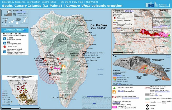
Update, September 20, 2021, 4:05 p.m., Pacific: A new vent has opened up about 900 meters north of the initial eruption site, and at a lower elevation. It’s in the municipality of El Paso (see El Pais graphic below tweet), and they are evacuating the nearby town.

Cabildo de La Palma released this map of the new flow as of Sept 20th. The main flow field isn’t shown, but is a little farther to the right on this image.
This is it during daylight, I believe; still trying to confirm night shots of it.
🇮🇨 #Canarias 🌋 Registro de la nueva boca eruptiva formada en el municipio de El Paso en la isla #LaPalma, un poco más abajo del centro eruptivo primario de esta erupción del Cumbre Vieja. Autoridades evacúan.
No se descartan nuevas bocas eruptivas y/o fisuras.
Vídeo: @RTVCes pic.twitter.com/uXHEgDBtqm
— EarthQuakesTime (@EarthQuakesTime) September 20, 2021
https://platform.twitter.com/widgets.js

Original post
It went off this morning afternoon, local time, per El Pais English; two lava-filled cracks (at least seven, per INVOLCAN) reportedly opened up in the mountainside at 3:15 p.m. Here’s the spectacular Reuters live feed, while I’m getting more details:
https://youtu.be/CmQVquojJfo&rel=0
Per El Pais linked above, the vents are in a remote area and about 50 people have been evacuated. Lava ignited some small forest fires, which are controlled.
An early video, per INVOLCAN:
<hr>
<blockquote class=”twitter-tweet”><p lang=”es” dir=”ltr”>ACABA DE COMENZAR LA ERUPCIÓN EN LA PALMA. ESTAS IMÁGENES HAN SIDO GRABADAS POR PERSONAL DE INVOLCAN. <a href=”https://t.co/CjdR7ZnKzh”>pic.twitter.com/CjdR7ZnKzh</a></p>— INVOLCAN (@involcan) <a href=”https://twitter.com/involcan/status/1439596728483725316?ref_src=twsrc%5Etfw”>September 19, 2021</a></blockquote> https://platform.twitter.com/widgets.js
<hr>
For more details and updates, check the La Palma page (Spanish) at El Pais.
The INVOLCAN team taking thermal images of the eruption of the Cumbre Vieja volcano #LaPalmaeruption pic.twitter.com/pNulCxDsQe
— INVOLCAN (@involcan) September 19, 2021
https://platform.twitter.com/widgets.js
Featured image: Cumbre Vieja, erupting off the Moroccan coast, as seen from the International Space Station
