May 13, 2021, 6:33 p.m., Pacific: Here’s part of the most recent update, per Google Translate:
Updated 12.05.
The Institute of Earth Sciences, University of Iceland, has published the latest data on the sizes of lava and lava flows in the Fagradalsfjall eruption.
The results now are good news, says the summary. “There has been a significant increase in lava flow in Fagradalsfjall last week. The average flow over the period is 13 m 3 / s, which is much more than the almost 8 m 3 / s previously measured. Increased flow has gone hand in hand with rising magma jets and the powerful flow of lava in the Meradalir valleys. The eruption is now twice as powerful as it has been for a long time. There have been signs of an increase in the past two weeks, but the measurement now removes all doubt “, says an announcement on the website of the Institute of Earth Sciences.
…
An interesting summary of the development of the eruption in the more than 50 days that have elapsed since its inception can also be found on the website of the Institute of Earth Sciences…
…
The production of the lava is even and there are no signs that the eruption is coming to an end. The magma rises from a depth of 15-20 kilometers and flows up in a straight channel up, but at a depth of about 100 meters a magma collection site has now been created in some kind of chamber…
It’s the first time I recall hearing an increase in eruption intensity described as good news, but:
- The eruption is far from people and their stuff.
- Iceland is open to some foreign tourists now; this volcano is a big draw and badly needed economic boost.
¡ESPECTACULAR!
Fantásticas vistas, sorprendentes bramidos, torrentes de lava, largos y continuos ríos de lava, una maravilla natural! 🤩
Erupción del volcán #Fagradalsfjall en #Islandia 🇮🇸 #icelanderuption #Volcano pic.twitter.com/M3znEhQePI— Geól. Sergio Almazán (@chematierra) May 13, 2021
https://platform.twitter.com/widgets.js
May 9, 2021, 7:39 p.m., Pacific: The intermittent fountaining is back. Also, the Icelandic Met Office posted this, including (per Google Translate):
Updated 07.05. at 11:45
The Scientific Council for Civil Protection met at a meeting yesterday to review the progress of the eruption, the distribution of lava, the production of eruptions and the pollution that accompanies the eruption.
Seismic activity on the Reykjanes peninsula is low and the earthquakes that are detected in the area where the corridor formed in the run-up to the eruption in Geldingatölur are estimated as aftershocks. No significant land changes have been observed on GPS devices and satellite images also show little change.
Measurements of the proportion of gas flowing from eruptions show that there is little change. Volcanic pollution is greatest at the eruption sites and decreases rapidly with increasing distance from them.
The results of measurements of heavy metals that come up with the lava were presented. Their accumulation is not considered to cause harmful pollution at this time, but it is important to monitor the pollution at the eruption site if the eruption activity continues in the coming months.
…
Boiling under the surface of the crater
Measurements by the University of Iceland Institute of Earth Sciences show that lava flow is still fairly stable and lava flow continues. The periodic behavior is likely to be related to changes in the shape and volume of the upper part of the eruption channel. Current conditions indicate that pop-up welding occurs rather shallowly below the surface of the crater, which separates the magma gases and the magma itself and increases its volume, with the result that magma jets form. At the same time, magma upwelling is fairly stable from the lower part of the earth’s crust. Most of the lava flow takes place in lava channels under the crater rim and the explosions do not affect it.
Here is an infrared LANDSAT image from earlier today: that thing is really filling up the valleys!

May 8, 2021, 4:01 p.m.:
And, just like that, the eruption decided it didn't want to do its fountain dance anymore. 🌋#Fagradalsfjall #eruption #tremor plots from @Vedurstofan pic @mblfrettir webcam pic.twitter.com/Dcc1SQFsRj
— Tom Winder (@twinderseis) May 8, 2021
https://platform.twitter.com/widgets.js
Now the very first crater reportedly is the only active vent.
No reds or yellows seen on TROPOMI, which is nice.
May 6, 2021, 8:15 p.m., Pacific: Part 2 is in the thread.
1/2 There was a slight change in the seismic tremor measurements at #Fagradalsfjall shortly before 4:30 am. Rhythm had been the same until then, approx. 10 min between magma jets. But this morning about half an hour passed between powerful magma jets. #eruption #Reykjanes pic.twitter.com/WfbywclGqf
— Icelandic Meteorological Office – IMO (@Vedurstofan) May 5, 2021
https://platform.twitter.com/widgets.js
A volcanologist reportedly said that one possible explanation of the new behavior is (per Google Translate):
Possibly we have a tank under the crater, a kind of lava pond. The crater is a nozzle on the pond and smaller than it in circumference. The hot magma rises around the bottom and is full of gas. The magma at the top is a little colder and has got rid of a lot of gas. Then we get a gust of [gas] that brings the hot gas-rich magma back up…When it starts to boil, the reverse pressure wave is formed, the system degasses and releases magma jets. The jets stand while the new magma degasses. After that, the magma jet falls down and the system starts charging for the next shot.
A vortex above flowing lava was spotted, too.
For the first time, I notice yellow and red colors (higher sulfur) on TROPOMI (see yesterday’s update). Simon Carn tweeted about it on the 5th.
So, sulfur emissions are increasing and apparently so is the rate of flow, though slowly.
Icelanders are still thrilled about their volcano, per online remarks and articles, but those in Reykjavik are not going to be happy if the wind direction does a 180-degree shift. And it will, at least per this site.
May 5, 2021, 8:35 a.m., Pacific: Not much news, although I read that a scientific committee meeting was scheduled after the earthquake swarm mentioned in earlier updates. No reports on that have appeared on the Icelandic Met Office Icelandic-language site yet.
Of note, after the volcano began its pulsations, it reportedly (Icelandic) began releasing more sulfur compounds. You can see this now in the latest TROPOMI satellite views (don’t panic, it will automatically show you the view after it loads; just adjust the map until you get to Iceland, which is located in between Greenland and Ireland/the UK).
Compared to say, La Soufriere St. Vincent or Mount Etna, it’s not much sulfur — though way more than this Iceland volcano was producing earlier (I checked TROPOMI) — and it certainly hasn’t gotten to the stratosphere, but if this going to continue for hundreds of years, as other Reykjanes Peninsula volcanism episodes have, could it add up to a global or, more likely, northern hemisphere climate impact of some sort eventually?
May 3, 2021, 11:37 a.m., Pacific: These tweets show the spectacular fountain pulsations, close up:
Our little volcano at #Fagradalsfjall is getting out of breath! 5 pauses to get it back in the past couple of hours, super clear in the @Vedurstofan tremor plots. And with a big 🇮🇹-style fountain to get back going again each time!! 😮🔥🌋 (@RUVfrettir webcam on point as ever) 1/3 pic.twitter.com/TdoUF6HMLl
— Tom Winder (@twinderseis) May 2, 2021
https://platform.twitter.com/widgets.js
and at a distance (from Reykjavik, I think):
The behavior of the #volcanic #eruption in #Geldinadalur by #Fagradalsfjall on #Reykjanes peninsula in #Iceland has changed over the past 24 hours. Rather than multiple fissures, there is now predominantly one crater erupting in a "pulsating" manner. pic.twitter.com/P132Pri6WO
— Gisli Olafsson (@gislio) May 2, 2021
https://platform.twitter.com/widgets.js
Of note, there has been an overnight increase in seismicity a couple of miles away, described as “trigger tremors” (source, Icelandic), whatever those are (can’t find a reference but I suspect from something I read weeks ago at the IMO site that it means earthquakes caused by changes in the regional stress field due to the eruption).
News reports mention a lake that is probably the same one described as a significant geographic divider by a geophysicist who was talking to the public in a video last October after the M5.6 rocked the peninsula.
He described the overall situation on the peninsula very clearly, and that’s always good to know even it might not have any relationship to events at and around Fagradalsfjall lately.
After all, a couple of other magma intrusions were detected besides the one that has erupted. However, AFAIK, the last official word on those is that no eruption from them is expected any time soon.
So, just for background on the big picture, here is that video again, from October 2020, after the M5.6 quake:
May 2, 2021, 12:38 p.m., Pacific: Just before midnight, local time, the single erupting crater’s activity changed to pulsations: dropping down to almost nothing for a while and then shooting lava up to as much as 900 feet or more.
You can see the change in this seismogram from the Icelandic Met Office:

The thick ribbon-like wave pattern is, I believe, typical for an fast-flowing eruption like this. Those spikes are the weird part.
“This is clearly a change in behavior, but I do not know if there is a difference in the amount that is coming up,” says Elísabet.
However, she says this behavior is not unusual in volcanic eruptions. Asked why the behavior has changed, Elizabeth says various theories about it.
“This is a change in pressure, it is something that is preventing the material from coming up for a while. Then it gets some extra power, breaks through something or whatever. ”
— Source (via Google Translate)
There might also be a new fissure trying to form (link is in Icelandic) but the cause of this ongoing ground smoking in front of the current eruption edifice is unclear.
Edit: This is the questioned area (2:54 p.m., Pacific: At the moment, they have shifted away from that area back to the main crater):
Here is the other RUV cam again:
Obviously, it isn’t safe to go in there right now and take readings, because no one yet knows what will happen next.
Given the behavior change, I’ve re-pinned this post.
May 1, 2021: The eruption continues, and at present, action is concentrated at one site:
Geophysicists report (Icelandic) that the lava chemistry is changing over time, though it still keeps up an intense flow rate. They offer two possible explanations for the change, only one of which suggests that it might signal an end of the eruption.
April 20, 2021, 7:59 a.m., Pacific: Yesterday, IMO issued a 30-day update on the eruption. (There’s other interesting news at this link, too.)
Here’s the Google Translate version of that update:
30 days from the beginning of the eruption at Fagradalsfjall
19.4.2021
Weather forecast for gas distribution
Automatic forecast for Fagradalsfjall and meteorological observations
See also posts on the Meteorological Office ‘s Facebook and Twitter pages.
Updated 19.04. at 12:10
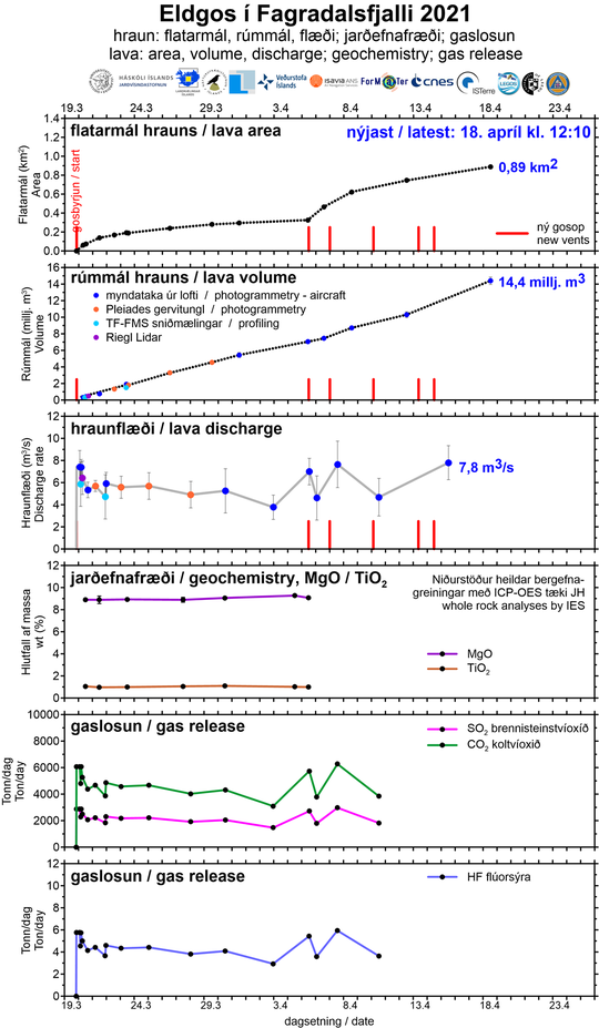
Today is about 30 days since the eruption at Fagradalsfjall. A summary from the University’s Institute of Earth Sciences states that the average lava flow for the first 30 days is 5.6 m 3 / s. Compared to most other eruptions, the flow is relatively stable. The measurements on the lava now show that there has been some increase in the last 1-2 weeks. The average flow for the first 17 days was 4.5-5 m 3 / s, but for the last 13 days it is close to 7 m 3 / s.
A comparison with other eruptions shows that despite the increase, the flow is now only about half of what occurred on average during the first 10 days at Fimmvörðuháls in the spring of 2010, which was a small eruption. A comparison with Holuhraun shows that the current flow is 6-7% of the average lava flow during the six months that the eruption lasted. The flow is similar to that of Surtsey for the longest time since the eruption began in April 1964 until the end of June 1967.
The power of the eruption has increased in parallel with the opening of more craters
Below you can see an overview published this morning by the University’s Institute of Earth Sciences on measurements of the lava flow of the eruption. The results are a total flow from all craters over a six-day period, 12-18. April had on average been almost 8 m 3 / s. This is a slight increase from the average flow in the eruption and confirmation that in parallel with the opening of more craters last week, the power of the eruption has increased somewhat, the area of the lava has reached 0.9 km 2 and the total volume is now over 14 million cubic meters.
The graphs above show, among other things, the development of the area and volume of lava and lava flow. It can be seen that the development of the area of the lava is not as “linear” as the development of the volume, but that is because to begin with the lava field grew to the thickness within Geldingadalur rather than spreading out. Work on processing geochemical and gas data is ongoing and the graphs will be updated as soon as it is completed.
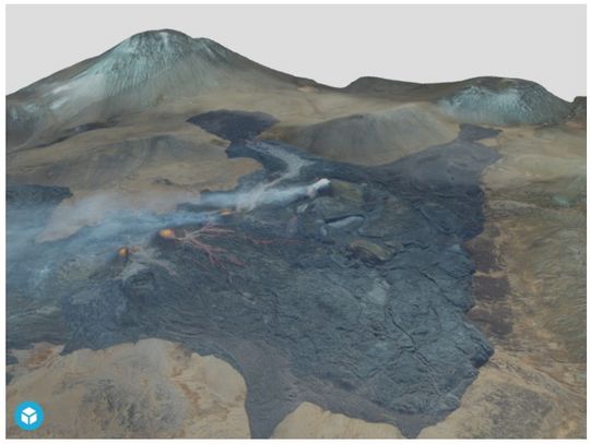
3D model of the eruption sites
The Icelandic Institute of Natural History operates an aerial photography studio where geological mapping is carried out using image measurement technology, where photographs are taken from the air and the images are used to create three-dimensional models. This method has been useful in mapping the eruption area by Fagradalsfjall, but with the 3D models it is possible to estimate the volume and thickness of the lava, lava flow and much more. You can view the 3D model by clicking on the image below.

April 14, 2021, 3:04 p.m., Pacific: Got distracted with La Soufriere St. Vincent, but things are chugging along in Iceland, too.
Per Jon Frimann, four new fissures opened up yesterday, making a total of eight so far. That isn’t yet confirmed on the Icelandic Met Office site, Icelandic or English language, but here is an overview.
This photo from around noon local time shows six active vents:

Everyone is giddy with delight about all the exciting lava views, but it’s a gas in a more literal sense, too:
The volcanic plume seen building up over #Fagradalsfjall here earlier today started heading towards Reykjavik with southerly winds having brought increased levels of gas pollution to the capital area this afternoon, as forecast by @Vedurstofan https://t.co/Nb8xz37SJB #iceland pic.twitter.com/dNAB7cLLqG
— Benjamin Hennig (@geoviews) April 14, 2021
https://platform.twitter.com/widgets.js
The Reykjanes Peninsula hasn’t seen one of these big effusive eruptions for seven thousand years. That’s in prehistoric times, so no one really knows yet what the local and possibly global environmental effects might be.
They probably won’t be too severe, if my reading is representative (it isn’t); haven’t come across mention of mysterious environmental disasters seven millennia ago, anyway.
I’ll keep reading, and in the meantime, hope for the best for those living on the peninsula and/or downwind of this eruption site.
April 10, 2021, 12:54 p.m., Pacific: A fourth fissure has opened up, and that probably won’t be the last, per the Icelandic Met Office.
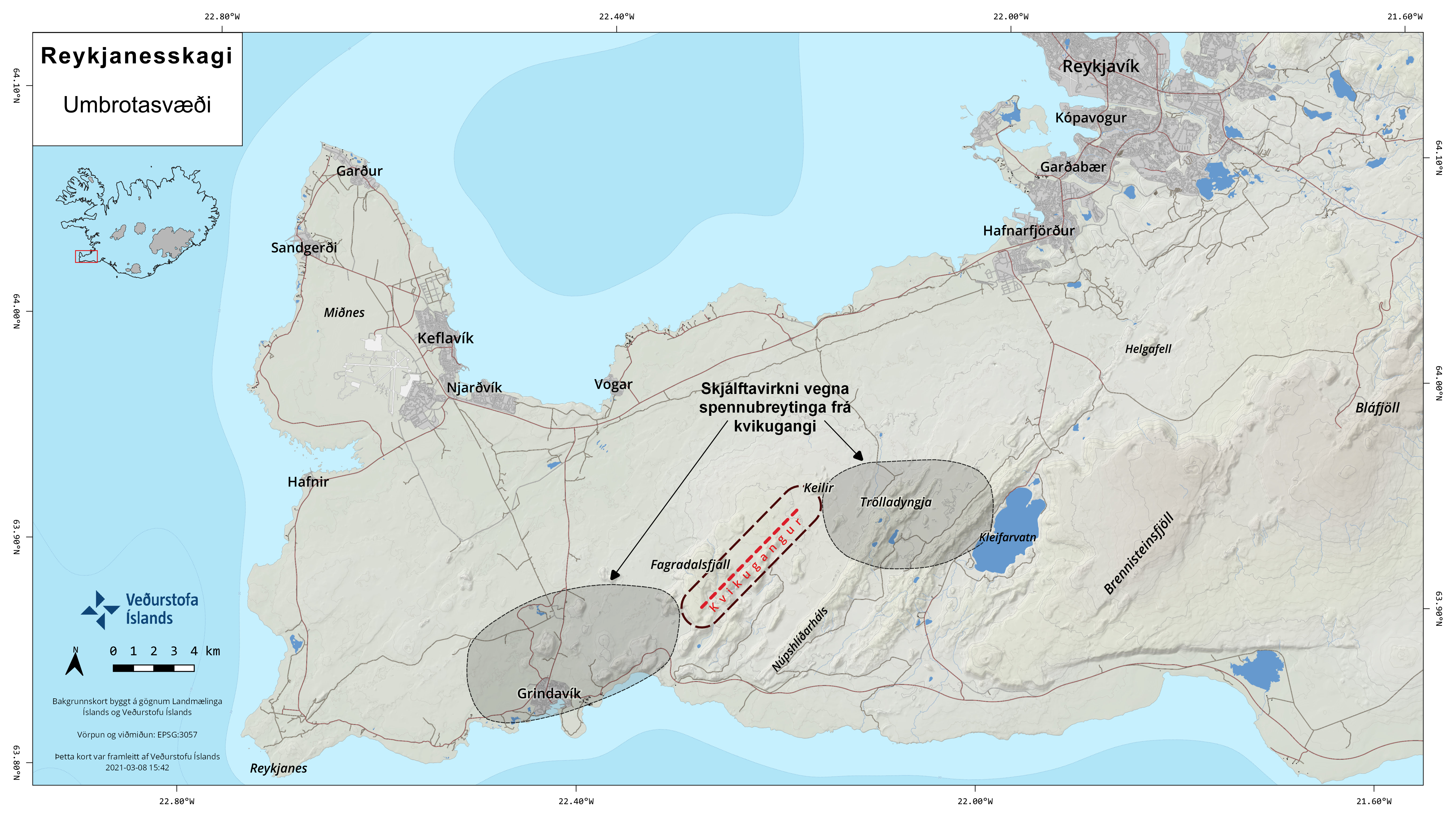
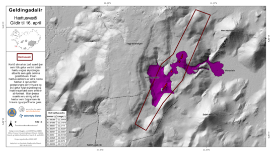
The Scientific Council for Civil Protection…meeting reviewed GPS measurements and satellite images to assess changes that have occurred in the area since new cracks opened. Signs of change appeared in new eruptions that opened on Easter Sunday and the eve of Tuesday. However, the changes are very small and foreshadowing before the cracks open are not detectable. There are indications that magma is shallow in the area south of Geldingadalur and northeast of the eruptions and it cannot be ruled out that more eruptions may open in the next few days or weeks. Opening a new eruption fissure without visible notice could pose an acute danger to people. The area covered by this danger is believed to be where the magma reached the surface or from the southwestern part of Geldingadalur and northeast to Litla-Hrúti.
The map defines the area where people can be in acute danger due to sudden events that can occur at eruption sites. Within the danger area, there is the greatest risk of opening more eruption fissures without warning, and this can be accompanied by a sudden and rapid lava flow that is difficult to avoid. Outside this area there are also other dangers associated with the passage of lava and gas accumulation. The map shows a draft of a new hiking trail east of the danger zone.
Steep and high edges on the lava fields at the eruption sites can be unstable. Large incandescent pieces of lava can collapse from them without warning, which can create great danger. Likewise, magma can shoot out from under the lava rim and that magma can travel very fast.
The greatest seismic activity in the last two weeks is north of the magma chamber and reaches Keilir. Just south of Keilir, by Litla-Hrút, shallow earthquakes are detected and this activity is closely monitored. Shallow earthquakes can be a sign that magma is looking to the surface. It can therefore not be ruled out that magma will reach the surface north of the magma chamber that reaches Keilir.
— Source, via Google Translate
It's truly spectacular at the moment Dan – the light is amazing 🔥
Hope you manage to visit it soon 😎 https://t.co/7jDWX7WOOy
— Dave McGarvie (@subglacial) April 5, 2021
https://platform.twitter.com/widgets.js
April 7, 8:46 a.m., Pacific: It’s confirmed; a third fissure opened at around midnight local time. That link will take you to the new live cam. Per the other live cam, lava from the second fissure eruption is still flowing into the next valley over.
April 6, 2021, 1:15 p.m., Pacific: Unconfirmed, from Jon Frimann:
During the night a new fissure was discovered between the new eruption and the old eruption. The fissure is about 150 meters long and there is hot air coming up from it.
There are reports of a new fissure north of the new eruption and land has been sinking down at that location. No other changes have been reported at the writing of this article.
And things are extremely difficult in nearby Grindavik indirectly because of the eruption.
Meanwhile, an earlier note today:
April 6, 2021: No changes, per a quick online look this morning. The scientists and emergency managers recognize that the game has changed. They’ve closed access to the now-famous first eruption site and reportedly are busy collecting data and meeting to discuss the situation. Today, weather conditions make gases very hazardous, especially in those valleys.
Meanwhile, the world’s volcanophiles miss their daily Iceland fix. 🙂
Here is Jon Frimann’s update today. (Just remember, he is a layperson operating his own private network of seismometers, not an official source.)
Meanwhile, Oraefajokull has had a few quakes, but as Jon notes in another post, that could just be typical behavior in this slumbering volcano. If an expert like Dave McGarvie has to think about the ramifications for other Icelandic volcanoes in what’s happening on the Reykjanes Peninsula, there is certainly no role for lay speculation just now.
We all should keep in mind, though, that, despite appearances, this isn’t your typical volcanic eruption scenario. These are spreading-ridge processes, complicated by the presence of a hotspot plume.
There are probably more possibilities here than anyone yet knows about.
At least COVID restrictions have prevented a massive influx of tourists. But still, almost 400,000 people live on this part of the Mid-Atlantic Ridge.
April 5, 2021: At least one new fissure vent has opened:
A new eruption crack opened around 12:00 p.m. today near the eruption sites in Geldingadalur. The first estimate is that the crack is probably about 200 metres long and is centered about a mile northeast of the eruption sites in Geldingadalur. The lava from the new crack runs down in Meradali.
Two Coast Guard helicopters are currently at the eruption sites to evacuate. A plane with scientists is on its way and they will assess the details of the location and size of the new eruption crack.
The flight code for Keflavík International Airport remains orange as it is a lava eruption with little to no ash distribution and is therefore not considered a risk of the eruption before air traffic.
The new eruption crack is well visible through the webcam that can be monitored on RÚV 2.
— Icelandic Met Office (Icelandic)
More info:
Nice drone footage of the new fissure(s) and their fountaining. Look how fast that lava is moving! This must be very hot. From what little I’ve read thus far, it has the same chemistry as the lava still being erupted in Geldingadalir Valley.
Here is a close-up. (Don’t panic about all that Icelandic — it’s a video.
April 4, 2021: Well, it has been chugging away, and Geldingalir Valley is almost filled up. No signs of slowing in the eruption are reported. There was a magnitude 3-plus quake near Mount Keilir in the past day, but authorities say this is not unusual near an eruption.
Here’s an incredibly relaxing and beautiful video by Jakob Vegerfors. Make sure the headphones are on or the speakers are turned up!
Note the size of bystanders and volcanologists for scale.
h/t mbl.is
Older posts and cam links:
After 20km of walking with my daughters to see the volcano, northern lights burst through the red volcanic plume and my daughter took this photo. Headlights filled the valley but the blue lights came from our SAR volunteers. Space lights, earth lights, human lights. pic.twitter.com/CjBCL4Nfs1
— Andri Snær Magnason (@AndriMagnason) March 31, 2021
https://platform.twitter.com/widgets.js
IMO updates (Icelandic) and live cam from RUV (national broadcaster):
The live-cam video on this page (words are Icelandic, but just click the video to watch) shows the eruption from a different angle. This direct link should work for viewing the new vent.
March 25, 2021, 8:55 a.m., Pacific: The IMO published a game-changing update today, so I did a separate post on it.
News reports also mention that very toxic amounts of CO2 and CO are being released, and satellites are also measuring a lot of sulfur gases. It’s not reaching the stratosphere to change global climate, obviously, but now that the lava field is so large and is enclosed in a valley, a visit there is perilous.
Speaking of valleys, Jon Frimann wrote yesterday that:
It is now estimated that the Geldingadalir valley is going to overflow in 8 to 18 days and currently a lava pond is forming at this location. Once that happens the lava is going to flow into nearby valley (I can’t find the name of it). One of the valley the lava is in the end going to flow into Nátthagi valley if the eruption lasts long enough.
I don’t know what his sources are, but that post also contains excellent links to interesting and authoritative additional information.
Here is a weird (in the original sense of that word) video from the Reykjavik Grapevine, uploaded about a week before the eruption began. It’s worth preserving, since some of those valleys may soon disappear forever.
I don’t know the terrain names here but do recognize Nátthagi Valley, where the eruption site was expected at that time. It’s featured at the end of the Brahms Lullaby segment, but there is much more incredibly beautiful but eerie video of this geopark after that.
“Published on Mar 12, 2021
The hazard zone where the Fagradalsfjall volcano could potentially go off, spewing gas and lava all around. Fagradalsfjall has been sleeping now for 6,000 years like an ancient giant waiting to wake up with a roaring yawn. Of course, we don’t want that, so here is the nice lullaby for the volcano…
Enjoy the captivating beauty and brutalism of the Reykjanes Peninsula and if you’re in Iceland—enjoy almost 40,000 earthquakes we’ve had in the last two weeks.”
— The Reykjavik Grapevine
March 23, 2021, 4:13 p.m., Pacific: A new crack has opened up on the side of the main vent and activity at both craters is picking up.
Here is a livestream from the other side of the valley (Icelandic, but just click the video).
The earlier close-up cam is still on, too.
Boffins have analyzed the lava and report that it is from the crust-mantle boundary — some really deep, primitive stuff! — and is VERY hot. You’ll notice in the cams that the lava moves quickly. That and its geochemistry are why.
They say that stuff like that hasn’t been seen on the Peninsula for some 7,000 years!
Its sulfur content is high, too.
Things seemed to be dying down at this eruption, but with the increased activity tonight, there is some speculation that this could turn into a shield volcano, if it keeps going.
Fortunately, per something I read early on, lava has to fill two big valleys before getting to people. And it’s nowhere near the first valley rim yet.
March 19, 2021, 5:36 p.m., Pacific: It’s on. The fissure eruption started about three hours ago east of Fagradalsfjall. This image above is from IMO, your best source of up-to-date information. That link is in Icelandic, but browsers handle that (I think Google Translate does a better job, though).
Here’s the first video:
A new video of the eruption at Geldingardalur valley in Reykjanes peninsula. Taken from the Coast Guard helicopter. #Reykjanes #Eruption #Fagradalsfjall pic.twitter.com/B862heMzQL
— Icelandic Meteorological Office – IMO (@Vedurstofan) March 19, 2021
https://platform.twitter.com/widgets.js
I’ll just add whatever supplemental information I come across.
Here is a webcam, but not close (fortunately, the eruption site is far from people).
Update: IMO now has a live close-up cam.
Per the March 20th update (and obviously, through the cam), this is not a big eruption. It also has quieted down a lot just now.
The historic thing is that it’s the first on the peninsula in roughly eight hundred years and, if history is any guide, this is only the first of many eruptions here. The activity could go on for centuries!
Edit: Here (Icelandic), emeritus professor Páll Einarsson shares his thoughts on how events might unfold over the long term. The quote below is from this article.
Update:
“While this eruption is going on, there’s no chance of it breaking out an eruption at another location. But we have to take it into account that this is the party of a much bigger scenario. There is no evidence that the [activity] is in itself coming to an end. It may therefore, soon or after some time, break out a new eruption or a new dynamic corridor.”
— Source, via browser translator
Update, March 21, 2021, 10:44 a.m., Pacific: Per browser translator: “The Sheriff’s Department has decided to close an area closest to the eruption crack in Geldingadalur, but the decision is based on a scientific council resolution that the large crater can [collapse] and the lava [flow] rapidly change direction…”
— Full article (Icelandic)
Something smaller happened yesterday — after all, that’s only a spatter cone, not a solid structure yet:
Amazing video of the main crater collapsing earlier today https://t.co/1cmxqYqdPE
— Gisli Olafsson (@gislio) March 20, 2021
https://platform.twitter.com/widgets.js
PRE-ERUPTION:
Here’s a quick yes (ja) or no (nei) on if there’s an eruption. Live cam of most likely site.Per IMO (Icelandic) on March 16th, the magma is moving in another direction.
March 18, 2021, 12:49 p.m., Pacific: Per the online IMO update about three hours ago, activity seems to have quieted down — there were “only” 1,400 quakes today!
Still, they note that this is the longest lowered-energy spell since this burst of activity began on February 24th.
However, this Reykjanes Peninsula process, which began last year as I recall, has proceeded in a stop-and-go pattern, as volcanism sometimes does; they’re taking a wait-and-see attitude and plan to hold the next scientific meeting next week.
March 16, 2021, 3:05 p.m., Pacific: No eruption yet, though the boffins did meet today. It’s complex. Their report and other information are at the IMO link above and worth reading in detail (Google Translate works better than my browser translator, but it’s not good with technical terms. For instance, it mentions “magma chamber” but there is no real magma chamber down there: it’s a dyke of molten rock, like these old ones elsewhere in Iceland that erosion has exposed:
This largest of these small #dykes is c.30% of the estimated width of the dyke intrusion at #Reykjanes
Like many dykes, they contain internal contacts indicating that they formed from multiple injections of magma.
All these smaller dykes might be connected at depth😎#Iceland pic.twitter.com/1u3xbM5nfx
— Dave McGarvie (@subglacial) March 15, 2021
https://platform.twitter.com/widgets.js
Here’s the basic information:
The greatest seismic activity associated with the magma tunnel, has shifted about 4-5 km northeast of the area by Nátthaga and is now located northeast of Fagradalsfjall, in the middle of the area where the magma tunnel has remained since the beginning of the eruption…The latest satellite images and GPS measurements indicate that magma continues to flow into the magma chamber. On the other hand, data indicate that the movement of the magma chamber to the south has stopped. There is a possibility that the magma met an obstacle at the southern end of the tunnel under Náttahagi and is now looking for an easier channel to the surface north of the magma tunnel.
March 14, 2021, 2:42 p.m., Pacific: No eruption yet but there were a couple of strong quakes (links and emphasis added to this IMO update, google-translated into English):
At 14:15 a magnitude 5.4 earthquake shook 2.5 km W of Nátthaga. Reports have been received from Sauðakrókur and the Westman Islands that he has been found. As a result, earthquakes measuring 3.0-4.0 in the magnitude of the Blue Lagoon have been detected.
At noon at 12:34 there was an earthquake of magnitude 4.6 in the south of Fagradalsfjall, the magnitude has been recalculated. He liked the SW corner of the country. Today, March 14, more than 2,000 earthquakes have been detected automatically.
Kristín Jónsdóttir, group leader of nature monitoring at the Meteorological Office, says the earthquake has been very strong. It was not at the site where magma is accumulating, but is probably a direct result of a sequence of events that began at noon with a magnitude 4.6 earthquake. There are no signs of eruptions and the quake has probably been a so-called trigger earthquake as a result of voltage fluctuations.
March 12, 2021, 11:12 a.m., Pacific: Some good news, per the IMO update page: there isn’t likely to be an explosive ash eruption, at least as things look now:
The Scientific Council for Civil Protection met today and reviewed the latest measurements and data received in the last 24 hours.
Main results of the meeting:
- Seismic activity now extends from the Nátthaga valley south of Fagradalsfjall, which indicates that the southernmost end of the magma tunnel lies there.
- The magma flow continues to expand, but there is some uncertainty about how fast the magma flow is. In recent days, data have indicated that the magma tunnel has been moving towards the south coast, but the latest measurements do not indicate that the tunnel has moved in the last 24 hours.
- Possible gas pollution in the event of an eruption was reviewed. The Environment Agency reviewed the measuring devices that have been installed to monitor possible gas pollution. (Note: This makes me wonder, too, about pollution from degassing where the shallow dyke sits in enclosed spaces like a valley.)
- If you look at the history of the eruption and geological research in the area, it is unlikely that the eruption fissure that opens south of Fagradalsfjall will reach the sea. As things stand now, it is unlikely that it will erupt underwater with the accompanying ash eruption.
- As previously stated in the announcements of the Scientific Council, that while the magma channel continues to expand, it must be assumed that the eruption can occur in the area. As the current situation lasts longer, the probability of an eruption increases.
March 11, 2021, 6:45 p.m., Pacific: There is no eruption yet, but the magma dyke keeps moving south, towards the sea (water would make any eruption explosive):
At its meeting tomorrow, the Scientific Council for Civil Protection will discuss the possibility that a possible eruption on the Reykjanes peninsula could reach down to the sea in the south.
Víkurfréttir first announced these ideas, but Kristín Jónsdóttir, a nature conservation expert at the Meteorological Office, confirms in a conversation with mbl.is that this possibility will be discussed at the meeting tomorrow.
“If we are interpreting the end of the corridor correctly, it is just a few kilometers out to sea,” says Kristín.
— Source (Icelandic, translation via Google Translate)
Someone tweeted a picture tonight, from ten days ago, of the valley that the dyke is moving into. Note the sea in the distance.
Photo taken (by me) 10 days ago, overlooking the Nátthagi valley which according to scientists at @Vedurstofan is where the dike on #Reykjanes is now heading.
You can explore the area yourself from a bird's view on @iceland360vr's page https://t.co/hNAc1E8KVI pic.twitter.com/uExUPRrwPY
— sigridurkristjans (@sissakristjans) March 11, 2021
https://platform.twitter.com/widgets.js
March 10, 2021, 3:53 p.m. Pacific Still waiting, but here is an article posted two hours ago with a few more details from a local professor.
March 10, 2021, 11:08 a.m., Pacific: Not yet.
From about six hours ago:
Woken up by an M5,2 at 3:15 like many in the Reykjavík area. Activity continues. Pressure is building up in the dike.. #Reykjanes #volcanomonitoring
— Kristín Jónsdóttir (@krjonsdottir) March 10, 2021
https://platform.twitter.com/widgets.js
Here is the latest from IMO, posted about half an hour ago, after another special meeting. As well, there is part of an earlier update from today (emphasis and links added by me):
Main results of the meeting:
- The magma channel continues to expand and most of the magma flow is confined to its southern end. As magma continues to flow into the corridor, it must be expected that it may erupt in the area. As the current situation lasts longer, the probability of an eruption increases. It is very unlikely that such an eruption will reach settlements.
- It is important to closely monitor the activity on the southern slopes of Fagradalsfjall to see if this activity is an indication that the magma channel is expanding to the south.
- Processing of satellite images received this morning and the latest GPS measurements confirm that magma collection is still restricted at the southern end of the magma tunnel that extends from Keilir to Fagradalsfjall. This place is still considered to be the most likely place in the event of an eruption.
- If the magma flow continues to expand and cause tension in the area, earthquakes can be expected to be found in settlements, similar to those that have occurred in the last 24 hours.
Sharp earthquakes were measured on the southern slopes of Fagradalsfjall last night and so far this day and are related to metabolism in the south of the magma tunnel. Several seismic earthquakes were also measured just north of Grindavík, but the formation of the magma tunnel causes [ground stress field] changes in a large area, including west of Fagradalsfjall. The seismic activity this morning has consisted of smaller earthquakes of about 2 magnitude. As it gradually fills the magma chamber, intermittent and abdominal seismic activity can still be expected.
Processing of satellite images received this morning and the latest GPS measurements, confirm that magma collection is still restricted at the southern end of the magma tunnel that extends from Keilir to Fagradalsfjall. This place is still considered to be the most likely place in the event of an eruption.
GPS measurements indicate that there is a slight slowdown in magma flow, but the uncertainty in those measurements is considerable as the magma lies very shallow in the earth’s crust (at a depth of about 1 km). However, it is the opinion of the Scientific Council that it is important to closely monitor the activity on the southern slopes of Fagradalsfjall to see if it is an indication that the magma tunnel is expanding to the south.
…
As the situation is assessed now, the magma is very shallow, at a depth of 1-1.5 km. It is important to realize that if magma breaks its way all the way to the surface, it can be expected that it could happen without much conflict or seismic activity. An example of this can be seen in the eruption that began at Fimmvörðurháls in 2010. There were no clear signs of the onset of an eruption on the Meteorological Office’s measuring equipment and it was news from eyewitnesses that confirmed that magma had formed. In this light, the Meteorological Office has set up webcams that can be used to monitor if magma occurs.
Updated 10.03. at 8.00
During the night, a magnitude 5.1 earthquake shook the region. 03:14 in the southwest corner of Fagradalsfjall and was found on the Reykjanes peninsula, the capital area, east of Hella and north of Búðardalur. A total of 700 earthquakes have been recorded since midnight, of which 20 have a magnitude of 3.0.
The activity, as yesterday, is mostly confined to the southern part of Fagradalsfjall, but several earthquakes were measured just northeast of Grindavík last night, the larger M3.9 at 04:35 and with very few at Trölladyngja.
No eruptions have been detected, nor have there been any significant changes in GPS data.
Yesterday, about 2900 earthquakes were measured on the Reykjanes peninsula, the largest 4.0 in magnitude at 23:01 last night. Yesterday morning at 5 the activity increased after a quiet day when a disturbance was detected in the southern part of the corridor. As a result, the activity was mainly confined to the southern part of Fagradalsfjall.
March 9, 2021, 2:09 p.m., Pacific: Magma is apparently on the move underground again, per an IMO update from about an hour ago (via browser translator):
At about 5:20 this morning, the activity at Mount Fagradals increased, south of the dynamic corridor. Nauru measured around the time the activity increased and lasted until about 7:00 p.m. The activity was very localised in the ailing corridor and is likely to be a sign of the expansion of the corridor. Since 7 p.m., there has been sustained mini-seismic activity in the area.
As noted by the Scientific Advisory Council yesterday, we can expect activity to be sectioned by seismic activity and unrest comparable to those measured this morning along the expansion of the dynamic corridor.
The activity this morning is at the point considered to be the most likely emerging site of the dynamic, which is south of the dynamic corridor as revealed in yesterday’s Scientific Advisory Council announcement.
This is what some of it looked like twelve hours ago to the seismologists:
3rd Tremor pulse -Intense overlapping microearthquakes- observed for 2 hours this morning, at the southern tip of the dike. These pulses are without dramatic deformation, so I would like to interpret those as a fast but minor propagation of the tip of the dike. pic.twitter.com/X7oQWS6RIQ
— Kristín Jónsdóttir (@krjonsdottir) March 9, 2021
https://platform.twitter.com/widgets.js
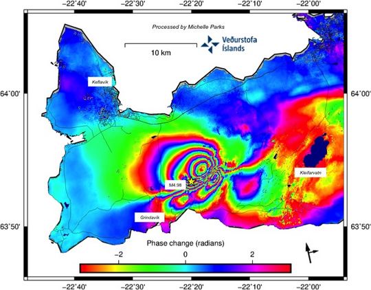
And here’s a visualization of what that dyke might look like if you saw it underground: compare the scale of ground features like Fagradsalfjall and Keilir with the IMO graphic below (from March 8th) to get an idea of the scale.
Cartoon by @RUVohf of what the magma intrusion under Reykjanes might look like (not meant to be an accurate illustration). The intrusion is several km long and deep but only a few metres wide. Taken from https://t.co/sSQSlaJELD pic.twitter.com/n49rDTFpB3
— Evgenia Ilyinskaya (@EIlyinskaya) March 9, 2021
https://platform.twitter.com/widgets.js
That’s a lotta lava!
By the way, that RUV link is a live information source, too (in Icelandic): latest report is of at least 8 quakes above M3 tonight!
March 8, 2021, 9:01 p.m., Pacific: Experts met this afternoon and there is a report on the Icelandic Met Office Icelandic-language page. At the moment, the magma seems to have stalled a little over half a mile below the surface.
Excerpt per Google Translate:
The Scientific Council for Civil Protection met at a teleconference today to discuss the earthquake on the Reykjanes peninsula. The meeting was attended by experts from the Icelandic Meteorological Office, the University of Iceland, ÍSOR, the Environment Agency, the Icelandic Institute of Natural History and Orkuveita Reykjavíkur as well as representatives from the Office of the Medical Director of Health, Isavia-ANS and HS-Orka.
The meeting reviewed the weekend’s activity, as well as reviewing measurements and data received in the last 24 hours.
Main results of the meeting
- It is still believed that if an eruption occurs, it would be on a fissure somewhere in the area bounded by Fagradalsfjall and Keilir where the magma tunnel is forming. There is no evidence of magmatic activity outside this area.
- The most probable source of magma, based on activity in recent days, is south of the magma chamber.
- The latest satellite images, GPS measurements and model calculations indicate that magma flow has decreased since the beginning of last week. The magma is shallow and eruptions must continue to be expected to erupt.
- If the magma flow continues to expand in the coming days and weeks, we can expect similar earthquake gusts [swarms] as occurred over the weekend.
…This picture shows a demarcated area where the magma chamber is forming under the earth’s crust. When magma flows into the strata and forms magma tunnels, as is currently the case in the metabolic zone between Keilir and Fagradalsfjall, pressure is formed in the earth’s crust. This creates tension on the east and west sides of the metamorphic area and is likely to be explained by the earthquakes that occur there, so-called “trigger earthquakes” which are signs of [ground energy] release but do not indicate that magma is moving in the areas where they are measured. Examples of such earthquakes could be seen on the eve of Sunday, March 7, when many powerful earthquakes were measured in a short time.