
As the air chills and days grow shorter, this might be a good time to revisit my live-blog of the trial by fire that Hawaiians endured during the summer of 2018.
That live-blog is as incoherent and piece-meal as you might expect of a nonprofessional observer, but you might get something out of it. I certainly learned a lot from following the East Rift eruption online, for example, how an eruption pauses from time to time, as well as what’s actually going on with the Hilina Slump.
It’s one thing to read about such things and quite another to watch it unfold — an experience that, until the time of the Internet, only a few lucky volcanologists have had.
Perhaps the most gob-smacking moment for me was when the volcanologists reported that the red-hot lava inundating the Puna District was not the stuff that had drained out of Kilauea’s summit lava lake just before rifts began opening up along the volcano’s flanks.
Correlation does not equal causation. And fire mountains are incredibly complex structures.
There was a human element, too.
Not having been to Hawaii, I hadn’t really understood until then that this US state is more than beaches, tourist resorts, luaus, and Honolulu. It was horrible and yet fascinating to watch Kilauea Volcano pour lava across what was basically small-town America.
I blogged it as best I could, only taking a break when the lava flow first reached the sea, followed by more spectacular flows that made international news. I’ll add a video in at the appropriate point to cover that part of the eruption, as well as an epilogue after the live-blog section. (Of note, technical problems just now prevent me from double-checking that the videos are embedded properly; I believe they are, but you might have to click the links to watch them in another tab.)
And since some of the links refer to current views as of the date of the post, and those views may have changed, you might want to do a search here for “East Rift” between 2018-04-01 and 2018-12-31 and start at the last page (the earliest photos/videos in the eruption)
It all started quietly enough in late April . . .
Repost:
This Hawaiian volcano is keeping USGS tweeters busy this week!
What’s going on at #Kilauea? This video sums it up. https://t.co/YfYoXp4AIq
— USGS Volcanoes🌋 (@USGSVolcanoes) April 23, 2018
https://platform.twitter.com/widgets.js
Here is a Sunday Morning Volcano post I did on Kilauea back in 2015.
April 27 update: HVO volcanologists did an in-depth report on Kilauea today for this week’s Volcano Watch. A few different things might happen next.
May 1, 2018: The floor of Kilauea’s active flank crater, Pu’U O’o, partially collapsed yesterday–
The volcanologists issued an Activity Notice and suggested some nearby communities pay close attention to the situation:
HVO/USGS Volcanic Activity Notice
Volcano: Kilauea (VNUM #332010)
Current Volcano Alert Level: WATCH
Current Aviation Color Code: ORANGE
Issued: Tuesday, May 1, 2018, 4:54 AM HST
Source: Hawaiian Volcano Observatory
Notice Number:
Location: N 19 deg 25 min W 155 deg 17 min
Elevation: 4091 ft (1247 m)
Area: Hawaii
Volcanic Activity Summary: Summary:
A collapse of the Pu’u Ō’ō crater floor Monday afternoon on Kīlauea Volcano’s East Rift Zone has prompted increases in seismicity and deformation along a large section of the rift zone, with seismicity currently occurring as far east as Hwy 130. A outbreak of lava in a new location is one possible outcome. At this time it is not possible to say with certainty if or where such an outbreak may occur, but the area downrift (east) of Pu’u Ō’ō is the most likely location, as this is where seismicity and deformation have been concentrated overnight.
Residents of lower Puna should remain alert and watch for further information about the status of the volcano; watch for Hawaii County Civil Defense messages at http://www.hawaiicounty.gov/active-alerts
Recent Observations:
Between about 2:00 and 4:30 pm on Monday, April 30, following weeks of uplift and increasing lava levels within the cone, the crater floor at Pu’u ‘Ō’ō on Kīlauea Volcano’s East Rift Zone collapsed.
Poor weather prevented HVO from flying over the activity or seeing details of the activity in our web cameras on site.
Following the collapse, HVO seismometers and tiltmeters recorded an increase in seismic activity and deformation from Kīlauea Volcano’s summit to an area about 6-10 miles downrift (east) of Puʻu ʻŌʻō. Overnight, this activity localized downrift of Puʻu ʻŌʻō and continued to propagate eastward along the rift zone.
The largest earthquake of this sequence so far was a magnitude 4.0 earthquake just offshore south of Pu’u ‘Ō’ō at 02:39 this morning,
Kīlauea’s summit eruption has thus far not been affected by the change at Pu’u ‘Ō’ō.
Hazard Analysis:
The migration of seismicity and deformation downrift (east) of Puʻu ʻŌʻō cone following Monday’s collapse indicates that a large area along the East Rift Zone is potentially at risk for a new outbreak.
The location of any future outbreak will determine what areas are in the path of new lava flows.
The situation is rapidly evolving and USGS Hawaiian Volcano Observatory scientists continue to closely monitor Kīlauea’s East Rift Zone and summit. More updates will follow as information becomes available.
Contacts: askHVO@usgs.gov
Next Notice: Daily updates on all volcanic activity at Kīlauea are issued each morning and posted on out website: https://volcanoes.usgs.gov/volcanoes/kilauea/status.html
You can sign up to receive these messages automatically by visiting https://volcanoes.usgs.gov/vns2/
The Hawaiian Volcano Observatory is one of five volcano observatories within the U.S. Geological Survey and is responsible for monitoring volcanoes and earthquakes in Hawai`i.
The last time Pu’u O’o collapsed completely, in 2011–
–it signified the start of a new eruption.
May 3, 2018, 2:40 p.m. Pacific: Here’s what I just got as an email; follow HVO at links given for more up-to-date information.
HAWAIIAN VOLCANO OBSERVATORY STATUS REPORT
U.S. Geological Survey
Thursday, May 3, 2018, 11:15 AM HST (Thursday, May 3, 2018, 21:15 UTC)
KILAUEA VOLCANO (VNUM #332010)
19°25’16” N 155°17’13” W, Summit Elevation 4091 ft (1247 m)
Current Volcano Alert Level: WATCH
Current Aviation Color Code: ORANGE
At 10:30 HST, ground shaking from a preliminary magnitude-5.0 earthquake south of Pu‘u ‘Ō‘ō caused rockfalls and possibly additional collapse into the Pu‘u ‘Ō‘ō crater on Kīlauea Volcano’s East Rift Zone.
A short-lived plume of ash produced by this event lofted skyward and is continuing to dissipate as it drifts southwest from Pu‘u ‘Ō‘ō. Anyone downwind may experience a dusting of ash.
At this time, the 10:30 earthquake has caused no other changes at Kīlauea Volcano. HVO will continue to closely watch monitoring data for any changes.
HVO has field crews working along the rift zone at this time. HVO will post additional information and photographs later today.
HVO Contact Information: askHVO@usgs.gov
MORE INFORMATION
Activity Summary also available by phone: (808) 967-8862
Lava viewing information:
Hawai’i Volcanoes National Park: https://www.nps.gov/havo/planyourvisit/lava2.htm
County of Hawaii: http://www.hawaiicounty.gov/lava-viewing/
Kalapana lava-viewing area: 808-430-1966
Subscribe to these messages: https://volcanoes.usgs.gov/vns2/
Webcam images:
https://volcanoes.usgs.gov/volcanoes/kilauea/multimedia_webcams.html
Photos/Video:
https://volcanoes.usgs.gov/volcanoes/kilauea/multimedia_chronology.html
Lava Flow Maps:
https://volcanoes.usgs.gov/volcanoes/kilauea/multimedia_maps.html
Definitions of terms used in update:
https://volcanoes.usgs.gov/volcanoes/kilauea/extra/definitions.pdf
Overview of Kīlauea summit (Halemaʻumaʻu) and East Rift Zone (Puʻu ʻŌʻō ) eruptions:
https://volcanoes.usgs.gov/volcanoes/kilauea/extra/background.pdf
Summary of volcanic hazards from Kīlauea eruptions:
https://volcanoes.usgs.gov/volcanoes/kilauea/extra/hazards.pdf
Recent Earthquakes in Hawai’i (map and list):
https://volcanoes.usgs.gov/hvo/earthquakes/
Explanation of Volcano Alert Levels and Aviation Color Codes:
https://volcanoes.usgs.gov/activity/alertsystem/index.php
https://pubs.usgs.gov/fs/2006/3139/
HVO Contact: askHVO@usgs.gov
CONTACT INFORMATION:
askHVO@usgs.gov
The Hawaiian Volcano Observatory is one of five volcano observatories within the U.S. Geological Survey and is responsible for monitoring volcanoes and earthquakes in Hawai`i.
You have received this email because you have subscribed to the USGS VNS.
To change your parameters, or unsubscribe from the service, go to https://volcanoes.usgs.gov/vns/
May 3, 2018: Here’s a map volcanologists put out yesterday afternoon. It shows the current situation at Kilauea, which has been described in more detail in earlier notes. It’s just a heads up; no evacuations called for yet.
Earthquakes migrate east of Pu‘u ‘Ō‘ō, signaling an intrusion of magma along the middle and lower East Rift Zone. Orange dashed line marks the approximate area within which most of the earthquakes are located. https://t.co/vJRUw2HRvh pic.twitter.com/nhMbMH20yW
— USGS Volcanoes🌋 (@USGSVolcanoes) May 3, 2018
https://platform.twitter.com/widgets.js
In case you’re wondering why they built so close to the volcano, the scale is different here. The Hawaiian Islands are volcanoes; you can’t avoid a fire mountain here. The Big Island, where activity on land is focused now, is made up of, I think, five volcanoes, including Mauna Loa (slowly inflating but not erupting), Mauna Kea, and Kilauea (currently erupting).
May 3, 2018, 10:42 p.m. Pacific: The eruption began about two two to three hours ago:
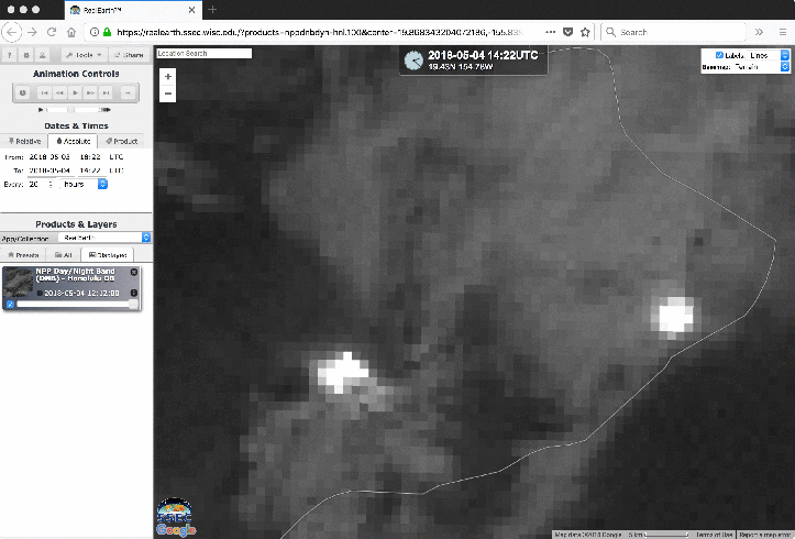
May 4, 2018: The HVO Kilauea update page appears to be offline just now, but the multimedia chronology of the eruption is working. Five fissures now, and two estates are under evacuation orders, per Hawaii County alerts page.
As for the quakes, no word yet on damage but there probably was some. No tsunami, but it changed water levels locally a bit, per Hawaii County (linked above).
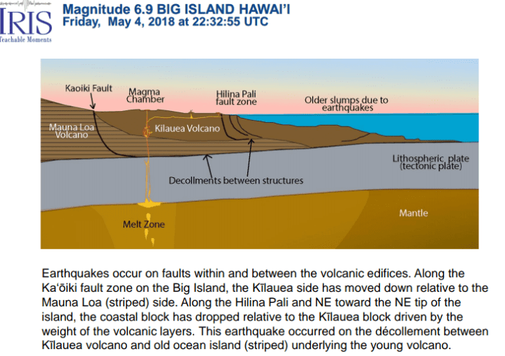
M 6.9 – 16km SW of Leilani Estates, Hawaii, 2018-05-04 22:32:55 UTC, 5.0 km depth. https://t.co/g2hWHdnPex This is in almost exactly the same location at the deadly 1975 M 7.1 earthquake. pic.twitter.com/ImkbbL1ruq
— USGS_Seismic (@usgs_seismic) May 4, 2018
https://platform.twitter.com/widgets.js
Pu’u O’o vent as the strong earthquake was rattling Hilo. pic.twitter.com/vnEpFwprww
— Lynn Kawano (@LynnKawano) May 4, 2018
https://platform.twitter.com/widgets.js
Here’s a live stream I found. (Sorry about the ad.)
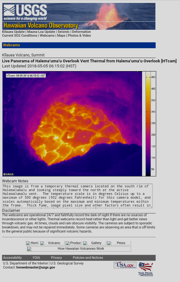
May 5, 2018, 9:20 a.m.: No new status updates yet. That may be a good thing; another possibly hopeful sign is that the summit lava lake is draining. It was overflowing recently and now it has retreated deep down into its vent (here’s the HVO thermal webcam view).
What does that lava lake drainage mean? I have no idea, but volcanologists are, of course, on it like white on rice.
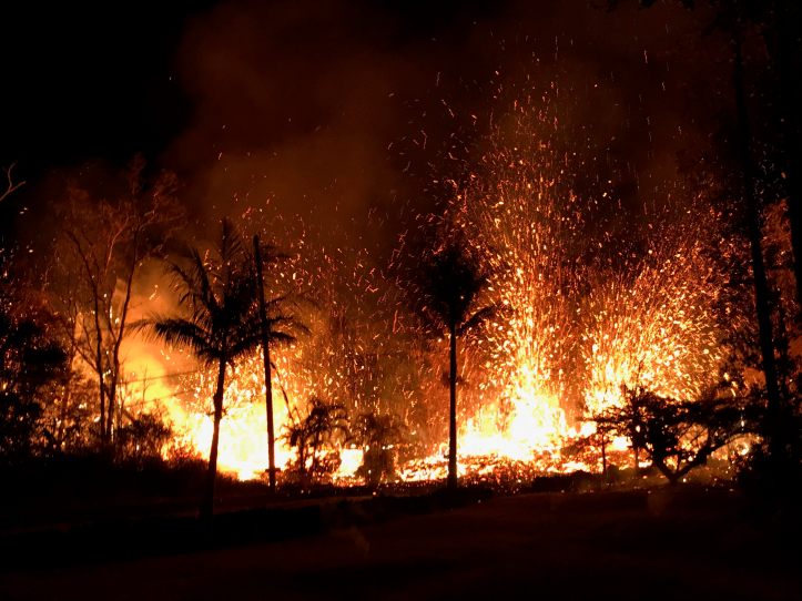
Yesterday five more fissures opened up in the neighborhood, including these:
2-hours before & after photos at Kaupili Street fissure site (via @USGSVolcanoes FB page) https://t.co/LTfNSQexllhttps://t.co/DtwNknOaj0 pic.twitter.com/XZ61gzW4nT
— ⚒Fumihiko Ikegami🚢 (@fikgm) May 5, 2018
They also closed Hawaii Volcanoes National Park:
Hawai’i Volcanoes NP closed: “M6.9 quake caused violent shaking … triggered rock slides … coastal cliff collapsed into ocean … fissures appeared in ground near Jaggar Museum … throughout day, rocks fell into lava lake, creating dark ash clouds” https://t.co/afadiO26AH
— Jascha Polet (@CPPGeophysics) May 5, 2018
This “Leilani Estates Eruption,” as Twitter seems to have christened it, is going to be a scientific landmark. That 6.9 quake yesterday now has its very own scientific discussion page, which is not something they do for every big tremor.
And here’s a look at the seimisicity pattern during this eruption.
The last week of earthquakes around Kīlauea. Can see swarm migrating east to location of Thursday’s fissure eruption in Leilani Estates (yellow), then activity seems to shift west after big M6.9 yesterday evening (orange/red)? pic.twitter.com/9je9vlljPt
— Chris Rowan (@Allochthonous) May 5, 2018
I’ve been looking at the international media coverage. There is a paradigm shift going on there, too. At first it was “oh, another Hawaiian volcano eruption”; then the dramatic story of vents opening up in a neighborhood drew a closer look; when the big quake happened, all media stories outside Hawaii that I read online used a Mount-St.Helens approach–the quake triggered the eruption–which perhaps it did, but it’s a lot more complicated than that. This morning, Weather Nation, at least, has picked up on the amazing fact that there are now multiple fissures (though at last USGS count it was six, not five [see yesterday’s update, below]:
NEW VIDEO: Four new #lava fissues opened up just before the 6.9 magnitude #earthquake on May 4th. Three of the new fissures have happened on residential streets. Some residential areas are also under mandatory #evacuations. We will continue to follow the situation in #Hawaii pic.twitter.com/N7cTKYBrTw
— WeatherNation (@WeatherNation) May 5, 2018
This is definitely one for the books. I hope it stops, soon, without more human consequences, but we’ll see. At least the summit lake is draining.
May 6, 2018, 8:58 a.m. Pacific:
Looks like Pele plans to stay in her new home for a while:
HAWAIIAN VOLCANO OBSERVATORY STATUS REPORT
U.S. Geological Survey
Saturday, May 5, 2018, 11:42 PM HST (Sunday, May 6, 2018, 09:42 UTC)
KILAUEA VOLCANO (VNUM #332010)
19°25’16” N 155°17’13” W, Summit Elevation 4091 ft (1247 m)
Current Volcano Alert Level: WARNING
Current Aviation Color Code: ORANGE
Lower East Rift Zone Eruption
The intermittent eruption of lava in the Leilani Estates subdivision in the lower East Rift Zone of Kīlauea Volcano continues. Fissure 7 stopped erupting in mid-afternoon. A new fissure erupted this evening near fissures 2 and 7, and lava fountains reached as high as about 70 m (230 ft). Early this morning, new ground cracks were reported on Highway 130, but no heat or escaping steam was subsequently observed.
Seismicity and deformation are consistent with continued accumulation of magma within the rift zone.
Residents should remain informed and heed Hawaii County Civil Defense closures, warnings, and messages (http://www.hawaiicounty.gov/active-alerts).
For maps showing the locations of eruption features, please see https://volcanoes.usgs.gov/volcanoes/kilauea/multimedia_maps.html
For information on volcanic air pollution, please see: http://www.ivhhn.org/vog/
May 5, 2018, 4:27 p.m. Pacific: USGS on the fissures:
[That original video doesn’t work; try the following one instead, which covers the same time period — Barb]
By the way, there are eight fissures now (see recent tweets in right sidebar).
May 6, 2018, 11:50 a.m., Pacific: 9 fissures, 9 homes gone:
This is a Civil Defense update for Sunday May 6, 2018 at 8:15 AM.
Hawaiian Volcano Observatory confirms 2 more fissures emerged between Leilani and Malama Street near Luana and Kupono Street last night, bringing the total number of fissures to 9 at this time. Active venting of lava and hazardous fumes continues between Mohala and Pomaika’i Street. Go to this link for more information: (link)
It is confirmed that at this time, at least 9 homes have been destroyed.
Due to the eruption, the following are issued:
Conditions permitting, Leilani Estates residents with property between Highway 130 and Maile Street will be allowed to enter the subdivision to complete evacuation of pets, medicine, and vital documents left behind between the hours of 8 AM to 6 PM.
Residents should retrieve their items expeditiously so others may go in after them.
Be aware of the very unstable conditions of air quality and of the roads. You will be required to leave the area if conditions become hazardous.
Residents will be required to provide identification and proof of residency in Leilani Subdivision. Primary Police checkpoint is established at Highway 130 and 132. A secondary checkpoint is at Highway 130 and Leilani Street.
Leilani residents entering must be on the alert for elevated levels of Sulfur Dioxide, wildfire, and volcanic eruption. People with respiratory problems are especially vulnerable.
No access is allowed at this time for residents of Lanipuna Gardens due to dangerous volcanic gases.
Please, the residents of Leilani need your help by staying out of the area. This is not the time for sightseeing.
County, State, and Federal partners continue to monitor the situation. You will be informed of any conditions that affect your safety.Thank you. This is your Hawaii County Civil Defense Agency.
May 7, 2018, 9:37 a.m.: Thirty-five homes gone, per this morning’s report. USGS map shows ten fissures spanning the East Rift Zone.
#hawaiianvolcanoobservatory update for #LeilaniEstatesEruption from 9PM HST May 6: Fissure eruptions continue, w/fissure 8 producing lava fountains and an ‘a’ā flow across Ho’okopu Road. Seismicity down in the ERZ but elevated at the summit. https://t.co/7sDZqcOJ5s #KilaueaErupts pic.twitter.com/x0CHgDD9Bv
— USGS Volcanoes🌋 (@USGSVolcanoes) May 7, 2018
https://platform.twitter.com/widgets.js
Per the latest update, “The intermittent eruption of lava in the Leilani Estates subdivision in the lower East Rift Zone of Kīlauea Volcano continues. Fissure 8 erupted lava fountains until about 4 p.m. HST, and the ‘a’ā flow advanced slowly northward through the afternoon, even after the lava fountains shut down. Geologists reported this early evening that the flow crossed Ho’okopu Road, a distance from fissure 8 of about about 1.1 km (0.6 miles). They also reported new ground cracks in the vicinity of fissures 8 and 9 that were emitting thick steam and gases, but no lava spattering was observed by the time of this status report.
Rates of seismicity and deformation decreased in the past day. The absence of additional deformation in the past day suggests a pause in magma acculumation in the distal part of the intrusion….”
Here is a time-lapse of the summit lava lake from April 26th on, showing it overflowing and then draining. Where it looks like there are a lot of sparks is when the M6.9 tremor hit and knocked some rocks into the lava. (h/t Dr. Janine Krippner via Twitter)
May 7, 2018, 5:24 p.m. Pacific: KHNL has an online headline that the USGS is investigating two more fissures that have opened up, but there is nothing in the attached story to indicate this and I haven’t found anything online from USGS or Hawaii County sources for confirmation. Something to keep an eye on, though, as this source has been reliable thus far.
And here’s something else to keep an eye on–the story linked in this tweet:
Seismo Blog entry on the #hawaiivolcano and #earthquake: A Slow Emergency and a Sudden Slump https://t.co/3F3sga1lSS pic.twitter.com/P5SoiKCLIJ
— Berkeley Seismo Lab (@BerkeleySeismo) May 7, 2018
https://platform.twitter.com/widgets.js
First and foremost, if you have ever wondered what the seismologists do in covering this eruption, here’s your answer. It’s fascinating.
The last part of the story illustrates another potential risk at Kilauea that is hard for us laypeople to understand. If the earthquakes are the slow emergency, then this is the sudden slump.
The article explains it well. I kind of worried when that M6.9 quake hit because I’d heard about it, though I didn’t know it was called the Hilina Slump. However, when I asked about it on a geology Usenet group many moons ago, they said it was buttressed. And this is also what Dr. Wikipedia describes (so it must be all right! BG)
I didn’t want to mention it until someone authoritative did, and that’s what they do in the above article. It doesn’t change anything about the ongoing situation–it’s just a reminder that Earth moves in large ways, and what you see isn’t always all that’s going on.
Obviously, the south flank didn’t collapse with last week’s quake; it didn’t even move as much as it has in the past. Things, good and bad, happen when they happen, and there’s little that any of us can do about it.
I’m mentioning it now because it’s always good to be informed about risks. The more knowledge, the better, even if this particular landslide doesn’t happen for tens of thousands of more years yet (which is quite likely, given its long silence already).
Just a heads-up for all of us that even more than the Puna District has a serious investment in this event.
In a way, the risk makes all of the Hawaiian Islands that much more beautiful and precious.
May 8, 2018, 1 p.m. Pacific: It’s official, the eruption is paused (but that doesn’t mean the lava has stopped degassing):
As of 7:00 am on May 8, the #LeilaniEstatesEruption in #Kīlauea‘s lower East Rift Zone has paused. Gas emissions continue & the fissure system is ~2.5 mi long. The pause is likely temporary & more flows/fissures are possible. #KilaueaErupts #usgs #hvo https://t.co/7sDZqcOJ5s pic.twitter.com/AigQoFr5xL
— USGS Volcanoes🌋 (@USGSVolcanoes) May 8, 2018
https://platform.twitter.com/widgets.js
May 8, 2018, 6:04 p.m.: Two more fissures began to erupt around noon, and now this:
EVACUATION – HVO confirms 2 new vents. All Lanipuna residents must evacuate now. Evacuate towards the ocean Isaac Hale Beach Park. Vent number 13 has opened near the intersection of Leilani Aveand Kahukai Rd and Vent number 14 near Kaupili St. and Leilani Ave.
— Hawaii EMA (@Hawaii_EMA) May 9, 2018
https://platform.twitter.com/widgets.js
The road system there is not extensive, from the looks of things on maps. When they use landmarks (the ocean) instead of road names or numbers, it’s not good. At least it’s still daylight in Hawaii. Thoughts and prayers go out to the people evacuating now!
May 9, 2018, 9:46 a.m.: At the moment, things seem quiet, per the online sources I check, though there is heavy degassing. Keep up to date with USGS/HVO and Hawaii County CD.
Found this IRIS teachable moment about the big quake last week; it contains a nice diagram about what Kilauea and the island of Hawaii look like in cross-section;
May 9, 2018, 11:17 a.m., Pacific:
HVO Kilauea ORANGE/WARNING – Increased potential for explosive activity at Kilauea summit https://t.co/ucQffPDuU9
— USGS Volcanoes🌋 (@USGSVolcanoes) May 9, 2018
https://platform.twitter.com/widgets.js
Per that link, the concern is that if the summit lava lake (which is dropping dramatically) gets below the groundwater level in Kilauea, there will be steam-driven explosions as water falls onto the lava lake.
May 9, 2018, 11:30 a.m. Pacific: Okay, this is actually what’s going on – I was wrong. The lava doesn’t fall “on” the lava. Well, see for yourself in this excellent diagram.
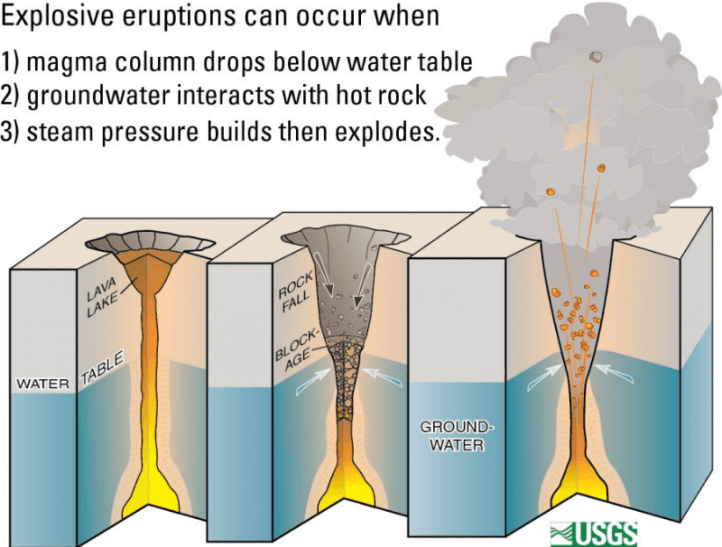
Too bad, when this happens, that we’ll lose our wonderful volcano cams. The nearby buildings and staff will be endangered, too.
Hawaiian volcanoes are not merely scenic.
Primary hazards of concern should this activity occur are ballistic projectiles (up to 2 m flying rocks) and ashfall (volcanic ash, which is like sand). https://t.co/uBWtkHIExD
— Dr Janine Krippner (@janinekrippner) May 9, 2018
https://platform.twitter.com/widgets.js
May 9, 2018, noon: From Washington VAAC:
FVXX21 KNES 091846
VA ADVISORY
DTG: 20180509/1846ZVAAC: WASHINGTON
VOLCANO: KILAUEA 332010
PSN: N1925 W15516AREA: HAWAIIAN.IS
SUMMIT ELEV: 4009 FT (1222 M)
ADVISORY NR: 2018/013
INFO SOURCE: HVO.
ERUPTION DETAILS: NEW VA EM
RMK: WE HAVE RECEIVED INFORMATION SUGGESTING A
POSSIBLE VA EMISSION. WE WILL GATHER FURTHER
INFORMATION AND ISSUE A FULL ADVISORY AS SOON AS
POSSIBLE.NXT ADVISORY: AS SOON AS POSSIBLE
Hope the scientists are okay.
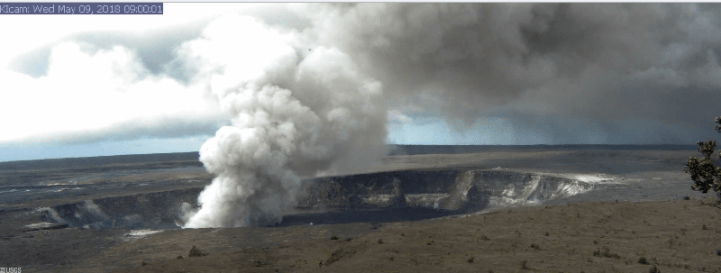
Here’s the current webcam image, a little after 9 a.m. Hawaiian time:
— Acker, J.G. (@ackerjg) May 9, 2018
https://platform.twitter.com/widgets.js
May 9, 2018, 1:24 p.m.: It was “only” a rockfall.
Rockfall generates a short-lived explosion at Halema‘uma‘u crater, Hawaii, at 8:27 a.m. HST, May 9. Explosion not caused by the interaction of the lava lake with the water table. https://t.co/hd8FPsBVgf pic.twitter.com/pNUcJYep9y
— USGS Volcanoes🌋 (@USGSVolcanoes) May 9, 2018
https://platform.twitter.com/widgets.js
Correlation (in time between USGS announcement and explosion) does NOT equal causation! A good example of how one must constantly look for more information and better interpretations during an unfolding event like this – very tough challenge for scientists, and doubly so for us laypeople.
May 9, 2018, 4:36 p.m. Pacific time:
Make sure your volume is up when you click the link; sound is a little low. They’re trying to figure out if and (if so) how much water was involved in this morning’s explosion at the summit.
Wondering what caused that big ash plume on #Kilauea‘s summit today? #USGS #HawaiianVolcanoObservatory Scientist-In-Charge Tina Neal explains why the explosion happened and why #HVO issued a special warning about possible explosive activity from the lava lake.#KilaueaErupts pic.twitter.com/D5LaZGh0y2
— USGS Volcanoes🌋 (@USGSVolcanoes) May 9, 2018
https://platform.twitter.com/widgets.js
Otherwise things at the fissures were quiet all day but now Fissure #15 has opened up.
May 9, 2018, 8:28 p.m. Pacific: The lava from Fissure 15 is heading east toward a geothermal plant. The last information I found on Twitter said that it was about a quarter mile away. Hawaii’s governor addressed that and the overall situation in a press conference this afternoon:
Here is a shot of the fissure and the plant, which is just under the red logo in the upper left in this shot.
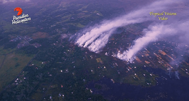
That image is from the overflight video below. It was taken before Fissure #15 erupted; the lava then reportedly was about half a mile from the plant.
Back in forestry college, a field professor told me when I’d lost a glove to just look for straight lines–only humans make straight lines.
Well, so does Pele.
May 9, 2018, 9:03 p.m.:
HAWAIIAN VOLCANO OBSERVATORY STATUS REPORT
U.S. Geological Survey
Wednesday, May 9, 2018, 4:55 PM HST (Thursday, May 10, 2018, 02:55 UTC)
KILAUEA VOLCANO (VNUM #332010)
19°25’16” N 155°17’13” W, Summit Elevation 4091 ft (1247 m)
Current Volcano Alert Level: WARNING
Current Aviation Color Code: ORANGE
Lower East Rift Zone Eruption
The intermittent eruption of lava in Leilani Estates in the lower East Rift Zone of Kīlauea Volcano continues. Visible activity this early afternoon was again focused on the northeast portion of the fissure area. Fissure 15 broke ground across Poihiki Road, generating a pahoehoe flow about 20 m (66 ft) long. During an overflight of the area about 3 p.m. HST, geologists observed a new steaming area uprift (west) of Highway 130. During a second overflight at 4:30 p.m., the area was still steaming.
Rates of motion increased late this morning on a GPS station 1.5 km (1 mile) southeast of Nanawale Estates. The direction of motion is consistent with renewed movement of magma in the downrift direction (to the northeast).
Rates of seismicity changed little throughout the day; located earthquakes were mostly uprift (west) of Highway 130. Gas emissions remain elevated in the vicinity of fissures.
Residents should remain informed and heed Hawaii County Civil Defense closures, warnings, and messages (http://www.hawaiicounty.gov/active-alerts).
The full update, including links and information about this morning’s explosion at the summit is here.
May 9, 2018, 10:03 p.m.:
Eruption update for May 9, 2018 at 1800. Fissure 15 in Lanipuna Gardens has paused; hazardous emissions continue. 10 homes evacuated on Alaili road.#mayorharrykim https://t.co/MBQ48hqY9l
— Mayor Harry Kim (@MayorHarryKim) May 10, 2018
https://platform.twitter.com/widgets.js
May 9, 2018, 11:10 p.m.: Just watched a live community meeting with HVO volcanologists on NaLeo.TV’s Channel 55, which is also an emergency broadcast channel. That’s a good information source.
The park is going to be closed Friday, as the scientists are expecting a steam event around that time–they can’t pin-point it exactly. Today’s explosion was just a rockfall (see updates below).
I also understood the experts to say that the groundwater-related steam explosions would start around the middle of next month, if things keep up at the summit as they are going now. Similar explosions happened in the 1924 eruption. In 1924, they went on, usually but not always several hours apart, for some four weeks or so.
The major impact on people not near the summit, i.e., most of the neighboring communities, would be ash fall. It wouldn’t be heavy, like in an eruption, but it would be irritating and a neuisance. They referred everybody to the USGS volcanic ash page.
There aren’t any clear indicators of such an eruption because it’s steam driven (just like you don’t know that a pressure cooker is going to blow until it does). It could cause a sudden burst of volcanic gases as well as a plume that could get up to 20,000 feet or more, up into the jet stream, which means it would get all over the southern island, not just carried on the prevailing winds. They pointed out ashfall isn’t life threatening but it is hazardous and recommended that people check out their website.
They also said that things like acid rain and water contamination would probably not be much worse than what Volcano and other nearby communities have had to deal with over the past 10 years with the lava lake.
Will post a link or embed the video if it becomes available.
In other news, the Fissure #15 eruption has paused. And some more good news —
#LeilaniEstatesEruption PENTANE/PGV LATEST: @CivilDefenseHI Administrator said crews have already relocated 30,000 gallons of pentane from Puna Geothermal Venture after threat from 15th fissure opens up heading toward plant https://t.co/cbfwS2HaXK @HawaiiNewsNow #HINews pic.twitter.com/rad44BgwdB
— Mileka Lincoln (@MilekaLincoln) May 10, 2018
https://platform.twitter.com/widgets.js
May 10, 2018, 12:32 a.m. Pacific: They’re going to rebroadcast the meeting summarized below on Channel 55 online at the times given below (times are in Hawaiian time, three hours earlier than Pacific, so the first rebroadcast is on now):
NOTICE OF REBROADCAST: You can find a rebroadcast of tonight’s May 9th, USGS HVO public meeting, on the status of Kilauea Volcano, at 9pm tonight, and tomorrow at 12am, 3am, 6am & 9am. #KilaueaEruption #NLTV pic.twitter.com/40SqYW93PY
— Nā Leo TV (@NaLeoTv) May 10, 2018
https://platform.twitter.com/widgets.js
Check it out – my summary just hit the high points. There’s a lot of good information.
May 10, 2018, 8:44 a.m. Pacific: Apparently no new fissures have opened up. It’s wonderful to see my favorite online local news source going back to other local stories!
The meeting last night got to YouTube (h/t to Dr. Janine Krippner):
As everyone catches their breath, awaiting Pele’s next move, here are a few things I didn’t get to post here yesterday. First and foremost is this incredible 3D model of the summit crater conduit USGS made by, basically, going up to the big hole in the crater floor and looking in.
1000 foot deep crater view! As many of you know, the summit lava lake in Halemaumau crater, #Kilauea has dropped 300m (nearly 1000 ft) since 1 May. These framegrabs are from a 3d model video HVO posted today made from thermal images collected by helicopter https://t.co/fNXLGcXzxx pic.twitter.com/1XiCFv0PK6
— Ken H Rubin (@kenhrubin) May 10, 2018
https://platform.twitter.com/widgets.js
Remember, just two weeks ago, that big hole was filled to overflowing!
May 10, 2018, 9:10 a.m. Pacific time: Just some more interesting things from today (which is quiet thus far, except for degassing, at the fissures in Puna District).
This diagram shows what the fissures might look like in cross-section:
Dyke model of #Kilauaea constructed from ALOS-2 InSAR and MAI data by T. Kobayashi, available on GSI web https://t.co/HD5kzcgJb2 pic.twitter.com/Ap54HijrmV
— Yu Morishita (@Yu__Morishita) May 10, 2018
https://platform.twitter.com/widgets.js
Aaand, here’s what fissure #14 looked like yesterday at the surface:
If you zoom in you can see incandescence (glowing) deeper in the cracks. Gas emission remains elevated near fissures. https://t.co/ggYWRgpysD
— Dr Janine Krippner (@janinekrippner) May 10, 2018
https://platform.twitter.com/widgets.js
May 10, 2018, 10:07 p.m. Pacific: It’s really wonderful not to have to do updates over and over again (though I am not complaining; I am very fortunate and my heart goes out to the people displaced and otherwise affected by this eruption).
Most recent Hawaii County CD tweet, about six hours ago, says that eruption is still paused. No USGS updates other than the routine daily one. This morning, the HVO scientist-in-charge also did a video update:
May 11, 2018, 3:27 p.m. Pacific: Looks like something is up. From roughly 25 minutes ago:
Lower Puna residents between Kapoho & Kalapana be alert for possible gas emissions/volcanic activity. For more: https://t.co/qJtOVlYTyI
— COH Civil Defense (@CivilDefenseHI) May 11, 2018
https://platform.twitter.com/widgets.js
This is not surprising, considering this morning’s update from HVO:
Summary: A pause in active eruption of spatter and lava along Kīlauea Volcano’s lower East Rift Zone continued through the night. However, earthquake activity and ground deformation continue and additional outbreaks in the general area of Leilani Estates are likely. Overnight, earthquake activity was concentrated on the downrift (east) side of the existing Leilani fissures. High levels of sulfur dioxide continue to be released from the fissure system.
May 11, 2018, 6:08 p.m.: Still holding. Here is a graphic showing, at the end of the playback, the area (on the right, i.e., east, that is being watched carefully today):
Seismicity rates on Kilauea have dropped, but clear pattern of earthquake activity moving east along the East rift remains, as USGS epicenters show. (I’m not the best movie maker with Google Earth, but here you go…) pic.twitter.com/yMxWvkqoDp
— Jascha Polet (@CPPGeophysics) May 11, 2018
https://platform.twitter.com/widgets.js
Also, just saw this on Twitter from this morning. It has more details:
May 11, 2018, 6:24 p.m.: This tweet is worth its own space. The lava that is coming out in the Puna District is not the lava that’s draining from the summit, apparently. The underground magma chamber has two entirely different vent systems, one to the summit and the other to the East Rift. (See diagrams lower down on the page)
Tina Neal from HVO: Material in current lava flows had probably been stored in rift zone since 1955, based on chemistry. Concern is “if fresher, hotter magma makes it to surface behind that”, which may be lower viscosity & cause more expansive lava flows. https://t.co/kGh9BRiyCV
— Jascha Polet (@CPPGeophysics) May 12, 2018
https://platform.twitter.com/widgets.js
Yeah. It’s bad news for perhaps tens of thousands of people if this scenario plays out. And as far as I know there is no way to predict exactly what is going to happen next.
May 12, 2018, 10:22 a.m. Pacific: Still in a holding pattern. This happened last night close to sunset, local time, but it was probably just rockfall.
More eruptions at Halemaumau Crater around 6:15pm HST #Kilauea #Hawaii #Volcano 📸: @AnthonyQuintano pic.twitter.com/hDRCltxzb4
— Honolulu Civil Beat (@CivilBeat) May 12, 2018
https://platform.twitter.com/widgets.js
I think when the steam explosions start at Kilauea’s summit, they will be much bigger, perhaps like Merapi’s phreatic eruption yesterday in Indonesia:
This explosion at an Indonesian explosion yesterday shows what happens when lava and groundwater meet. It’s why they’ve closed Hawaii Volcanoes park.
May 12, 2018, 10:54 a.m.:
#LeilaniEstatesEruption LATEST: @CivilDefenseHI officials monitoring new cracks that have developed along Hwy132 makai of Noni Farm Rd. & are widening; no smoke, sulfur or thermal activity detected at this time https://t.co/K3T19fSkWe @HawaiiNewsNow pic.twitter.com/XLNA7IVo1p
— Mileka Lincoln (@MilekaLincoln) May 12, 2018
https://platform.twitter.com/widgets.js
May 12, 2018, 12:55 p.m. Pacific:
#HVO #Kilauea update 9:10AM HST, May 12: New fissure (16) confirmed ~1 mile NE of fissure 15 @ NE end of #LeilaniEstates vents. No significant lava flow yet but elevated earthquake activity & deformation continue, additional outbreaks like. https://t.co/7sDZqcx8dU #KilaueaErupts
— USGS Volcanoes🌋 (@USGSVolcanoes) May 12, 2018
https://platform.twitter.com/widgets.js
#BREAKING #LeilaniEstatesEruption: @CivilDefenseHI confirms a 16th fissure has broken out east of the Puna Geothermal Venture plant property and northeast of the Lanipuna Gardens subdivision in a forested area; other 15 fissures “quiet” @HawaiiNewsNow (Video: Mick Kalber) #HINews pic.twitter.com/z7reXblpsX
— Mileka Lincoln (@MilekaLincoln) May 12, 2018
https://platform.twitter.com/widgets.js
May 12, 2018, 2:35 p.m. Pacific: Not specific to Fissure 16, but just issued, per Mayor Kim via Twitter, and a good idea:
May 12, 2018, 5:16 p.m., Pacific:
Fissure 16 is still spattering lava, per Civil Defense, but Highway 132 is open.
May 12, 2018, 8:21 p.m. Pacific: Some images of the Fissure 16 eruption:
After a pause in activity, the East Rift Zone eruption of #KilaueaVolcano resumed this morning (May 12) with a new fissure (16) at 7AM HST, along the alignment of earlier fissures and ~0.8 miles northeast of fissure 15 and Pohoiki Road. #KilaueaErupts #usgs #hvo #LeilaniEstates pic.twitter.com/zF507ffeOT
— USGS Volcanoes🌋 (@USGSVolcanoes) May 13, 2018
https://platform.twitter.com/widgets.js
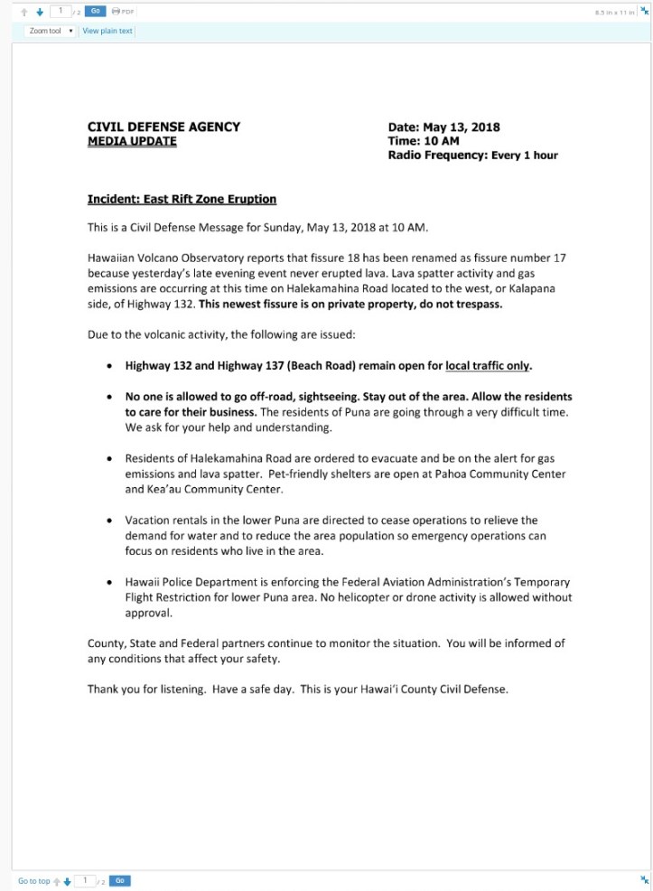
May 13, 2018, 10:01 a.m.: Two new fissures and some evacuations. More information at the USGS Kilauea update page. Also:
#HVO #KilaueaVolcano May 12 evening update (7:07PM HST): New outbreak reported at 6:00 pm ~0.5 mile northeast from end of Hinalo Road, very close to fissure 16 Lava is actively spattering and degassing but no flow has yet formed. https://t.co/7sDZqcx8dU #KilaueaErupts pic.twitter.com/Lea1b41NSo
— USGS Volcanoes🌋 (@USGSVolcanoes) May 13, 2018
https://platform.twitter.com/widgets.js
And from Hawaii County:
Emergency Message For Sunday May 13 At 5:45 AM
This is a Civil Defense Emergency Message for Sunday, May 13, 2018 at 5:45 AM.
Department of Public Works and Police have verified reports of a new fissure, number 18, to the west, or Kalapana side of Highway 132 on Halekamahina Loop Road. At this time, steam and lava spatter activity has started from this new fissure.
Due to the volcanic activity, the following are issued:
Residents of Hale Kamahina Loop Road are ordered to evacuate.
The Pahoa Community Center and Kea’au Community Center are open. Food will be provided and the shelters are pet-friendly.Thank you for listening. Have a safe morning. This is your Hawai‘i County Civil Defense
This video is from last night–it’s nice that they left their car for the neighbor: she is probably using it this morning to evacuate.
May 13, 2018, 10:45 a.m. Pacific: I’m not sure of the source, but Dr. Poulet is reliable:
Tina Neal, USGS scientist-in-charge at Hawaiian Volcano Observatory: growing fears that “hotter, fresher” magma could be making its way downslope. Eruptions of fresher lava would increase the risk of fountains and more significant flows, she said. https://t.co/cslGtXfvbX
— Jascha Polet (@CPPGeophysics) May 13, 2018
https://platform.twitter.com/widgets.js
As noted below, the fissure lava is coming from an older eruption, not the draining lava lake or Pu’u O’o crater’s contents. It’s unclear where that current lava went, the volcanologists said in their community meeting on the 9th.
May 13, 2018, 12:13 p.m. Pacific:
From latest HVO update, 8:25 a.m. HST:
LOWER EAST RIFT ZONE
Eruption of lava continues along Kilauea Volcano’s lower East Rift Zone. A new outbreak early this morning just over a half mile northeast of the end of Hinalo St. and about one half mile south of highway 132 has been confirmed. Hawaii County Civil Defense reports the outbreak is on Halekamahina Loop Road. Aerial observations of this new fissure indicate it is at least several hundreds yards long and producing spatter rising many tens of feet into the air. A slow-moving lava flow is moving away from the vent.Elevated earthquake activity and ground deformation continue and additional outbreaks in the area remain likely.
Conditions around the erupting fissures can change very quickly. Residents in lower Puna should remain informed and heed Hawaii County Civil Defense closures, warnings, and messages (http://www.hawaiicounty.gov/active-alerts).
They also included a link to a good centralized information source: https://vog.ivhhn.org/
Per local news report: “Cracks along Highway 132 near Noni Farms Road have reportedly worsened considerably and are steaming, and authorities are concerned it could soon develop into the site of a 19th fissure. This roadway is important because the route is meant to serve as the detour route to the Kapoho and Kalapana areas. Residents there will now need to use Old Government Road or Beach Road to get out of their communities.”
Ah, here’s the news report about the new, hotter magma that may be on the way.
May 13, 2018, 1:06 p.m.: About 40 minutes ago, saw this little rockfall explosion ash through the webcam:
Apparently it was more than just a “puff,” because Washington VAAC issued a notice, with this graphic:

Of course, all eyes are on Kilauea now to get word out to pilots in those very heavily traveled airway lanes ASAP if and when the expected big phreatic summit explosions start.
May 13, 2018, 1:40 p.m.: From Hawaii County (unfolding events also include scientists changing their minds!):
PS: Thanks to The Watchers for publishing my article updating the Kilauea eruption! This is a data-rich news site that anyone who follows Flight To Wonder is going to love!
May 13, 2018, 2:30 p.m.: No sign yet of explosive interactions between water and lava at the summit, and the situation remains dynamic in the East Rift Zone, with no big lava flows there at present.
It’s always so sad to see a natural disaster picture with a house in it. With, say, a tornado, the house will survive anything other than pretty much a direct hit and then it’s back to normal. With lava, there is never that ability to return to the way things were–everything is new again.
The good news is, we have been living with this process forever. Goodbyes are hard, but there are always new hellos to look forward to.
#LeilaniEstatesEruption UPDATE: 18th fissure off Halekamahina Loop Road west, or Kalapana side, of Hwy132. Eyewitnesses say it’s approaching Kapoho. @CivilDefenseHI says no houses/structures have been lost with eruption of last 3 fissures in past 24 hours https://t.co/6a53L9HwUI pic.twitter.com/SGluil282Q
— Mileka Lincoln (@MilekaLincoln) May 13, 2018
https://platform.twitter.com/widgets.js
May 13, 2018, 4:05 p.m.: Still holding, as far as I can see online. Just as background–
This graph of the distance between two GPS stations located on opposite sides of Kīlauea's caldera could be interpreted as indicating deflation of the magma chamber over the past few weeks that exceeds the sum of the steady inflation over previous 5 years https://t.co/C5PrMHBNwc pic.twitter.com/iKx5HbHGFX
— Jascha Polet (@CPPGeophysics) May 13, 2018
https://platform.twitter.com/widgets.js
If this is the case, then one of two big questions that the scientists are probably pondering is where all that magma went.
It’s hot and therefore less dense than surrounding rocks, so it’s unlikely to sink back down into the mantle. Chemical testing apparently showed that the stuff coming out of the East Rift fissures is from the 1955 eruption, not what was in Pu’u O’o and up at the summit until very recently. So it hasn’t erupted yet.
Most likely the summit and Pu’u O’o stuff is still inside the volcano, where the earthquakes are, since lava breaks rocks and changes stress fields as it moves around.
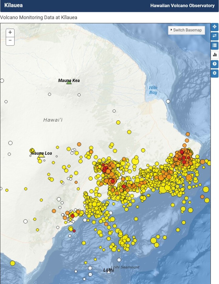
Current map of earthquakes, per HVO/USGS:
Which brings up the second big question: if and when it will erupt.
And I don’t think there is a reliable way for anyone to answer that question right now. It could happen in the next moment; it might not happen until tomorrow, or next week, or next year; heck, it could be another 63 years before Pele decides to unleash some of it.
And all this time, given the potential for an outbreak of major lava flooding, the authorities, as well as the scientists, must stand by and watch and wait.
I don’t envy them their jobs, but I think they’re all doing very well.
May 13, 2018, 5:07 p.m.: Still holding; just more video, plus the current Hawaii County CD message.
I mention earthquakes and lava movement in the 4:05 p.m. post below above. The Pacific Tsunami Warning Center just released a YouTube video showing how that seismicity used to be and how it picked up, especially after P’u O’o drained:
May 13, 2018: 5:33 p.m.: One structure reportedly gone.
May 13, 2018, 10:29 p.m. Pacific: Another fissure. It’s actually the 19th, but one of yesterday’s fissures didn’t erupt lava, so the geologists didn’t include it in their numbers. This is officially fissure #18:
#BREAKING #LeilaniEstatesEruption: @CivilDefenseHI confirms fissure 18 has opened up near Halekamahina Lp Rd between fissure 16 & 17; Active fumes & lava spatter are occurring; continued earthquake activity & additional outbreaks are likely https://t.co/eQaji3lHBC @HawaiiNewsNow pic.twitter.com/OQQReUnXOg
— Mileka Lincoln (@MilekaLincoln) May 14, 2018
https://platform.twitter.com/widgets.js
I think that interview was done before fissure #18 opened tonight.
Here is a link to one of the Civil Beat’s Facebook feeds:
The feed from @CivilBeat and @AnthonyQuintano atm is amazing. Fissure 17 venting gasses on one side and lava fountains (and projectiles) on the other!! #Kilauea https://t.co/WjRSH66pdw
— Dorian H (@The_Wolf71) May 14, 2018
https://platform.twitter.com/widgets.js
Fissure #18 going off right now #Kilauea #Hawaii pic.twitter.com/pXfuPOb4Ji
— Anthony Quintano (@AnthonyQuintano) May 14, 2018
https://platform.twitter.com/widgets.js
May 13, 2018, 11:44 p.m. Pacific: USGS doesn’t mention a new fissure #18 in the update they just released. I wonder if it is really new, since other reports said it was between #16 and #17, and there was that mixup in fissure numbering today. Anyway, the update has good information about flows:
HAWAIIAN VOLCANO OBSERVATORY STATUS REPORT
U.S. Geological Survey
Sunday, May 13, 2018, 8:28 PM HST (Monday, May 14, 2018, 06:28 UTC)KILAUEA VOLCANO (VNUM #332010)
19°25’16” N 155°17’13” W, Summit Elevation 4091 ft (1247 m)
Current Volcano Alert Level: WARNING
Current Aviation Color Code: ORANGELower East Rift Zone Eruption
Eruption of lava continues from the northeast end of the active fissure system. Residents in lower Puna should remain informed and heed Hawaii County Civil Defense closures, warnings, and messages (http://www.hawaiicounty.gov/active-alerts).
As of late today, activity was dominated by lava fountaining, explosion of spatter bombs hundreds of feet into the air, and several advancing lava flow lobes moving generally northeast from fissure 17 at the downrift (northeast) end of the new fissure system. As of about 7 pm, one lobe was 2 yards thick and advancing roughly parallel to Highway 132. The flow front was just over a half mile southeast of the intersection of Highway 132 and Noni Farms Road.
Based on overflight images late this afternoon, additional lava from fissure 17 was also moving slowly southeast. Volcanic gas emissions remain elevated.
For the most recent map showing the locations of activity, please see https://volcanoes.usgs.gov/volcanoes/kilauea/multimedia_maps.html
HVO field crews are on site overnight tracking the lava flow as conditions allow and reporting information to Hawaii County Civil Defense.
This eruption is still evolving and additional outbreaks of lava are possible. The location of future outbreaks could include areas both uprift (southwest) and downrift (northeast) of the existing fissures, or, existing fissures can be reactivated. Communities downslope of these fissures could be at risk from lava inundation. Activity can change rapidly.
For information on volcanic air pollution, please see: http://www.ivhhn.org/vog/
, , ,
May 14, 2018, 8:23 a.m. Pacific: Checking online sources first thing this morning shows that last night’s discrepancy in information persists. There is no mention of the Fissure #18 that opened up last night, per tweets from Hawaii County CD and Mayor Kim, in USGS websites or tweets that I’m following. No new activity notice came in overnight on the USGS volcano email feed (which you should subscribe to because it’s free and up to date. without spam).
And yet, seven hours ago, there was still news:
#BREAKING #LeilaniEstatesEruption #HappeningNow: Incredible new video of fissure 18, which opened up near Halekamahina Loop Road between fissure 16 and 17 to the west, or Kalapana side, of Highway 132 just before 7 PM; https://t.co/KDczzqWX5a @HawaiiNewsNow #HINews #HawaiiNews pic.twitter.com/2qMENMDs5C
— Mileka Lincoln (@MilekaLincoln) May 14, 2018
https://platform.twitter.com/widgets.js
Also, this morning KHNL reports:
They just keep coming — eruptions, one after another, spewing out lava and toxic gas in parts of lower Puna where life has all but come to a standstill amid the fiery shows.
Over the weekend, three new fissures opened up. The latest — no. 18 — was confirmed on Sunday evening and heightened fears about the possibility of a mass evacuation if the volcanic activity continues.
Officials said the outbreak was between fissures no. 16 and 17, and was actively spitting out lava and fumes.
About 8 p.m. Sunday, Pomai Kajiyama posted a video on Facebook showing a huge cloud of smoke emanating from what appears to be the newest fissure.
“I’m out here in Kapoho, and there was just a huge explosion,” Kajiyama said.
None of that sounds like rumor, so it’s probably safe to assume that there is a fissure #18 erupting since last night. The USGS is probably monitoring it even more closely than ever and keeping local authorities up to date on the situation. If the discrepancy in news reports isn’t just something to do with that renaming of a fissure yesterday (see notes below), then it may be something new about this Fissure 18 that is absorbing all the scientists’ attention right now. Time will tell.
May 14, 2018, 9:08 a.m.: Ah, here we go!
#Kilauea,18 fissures now, but 17 is the most voluminous…and #LavaFountain still #erupting. Video of May 13 4:30PM heli flight – steam jets throwing #SpatterBombs up to 500 ft. East #aa #lavaflow cascading into steaming pit. #Hawaii https://t.co/4xgDUM0aeZ pic.twitter.com/JJU1Y9kI5V
— USGS Volcanoes🌋 (@USGSVolcanoes) May 14, 2018
https://platform.twitter.com/widgets.js
May 14, 2018, 12:14 p.m.: New fissure in Lanipuna Gardens, per Hawaii County CD, #19 (and the twentieth fissure, if you count all from the beginning as reported).
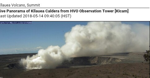
Also, the summit webcam currently shows this:

Probably just a rock fall, as a phreatic explosion plume would be going straight up. A pretty big rockfall, though–it might increase the chances of the conduit become plugged, though obviously the lava lake is still open, as it exploded to produce this ash.
Here’s a video update from earlier this morning, before the new Lanipuna Gardens fissure opened:
There seems to be some more explosive activity at the summit.
Here are a few webcam screen captures:
Washington VAAC notice here, plus this graphic:
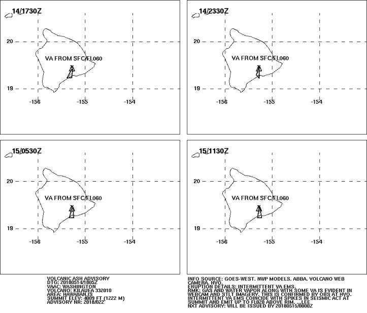
COINCIDE WITH SPIKES IN SEISMIC ACT AT SUMMIT AND
EMIT UP TO FL020 ABOVE RIM,” per VAAC. Translation: Some more earthquakes at summit have resulted in these rockfall-caused ash clouds that can go up to 20,000 feet.
12:44 p.m., Pacific: This just tweeted by the USGS:
#HVO #KilaueaVolcano May 14 update (8:36AM HST) | #LERZ: 19 fissures, #LavaFountain activity from fissure 17 feeds ~1-mi-long #lavaflow, 1/2 mi south of HY 132. #Summit: #deflation continues, many #earthquakes last night, steady steam #plume & some #ash. https://t.co/7sDZqcOJ5s pic.twitter.com/NZ2P7XGuew
— USGS Volcanoes🌋 (@USGSVolcanoes) May 14, 2018
https://platform.twitter.com/widgets.js
May 14, 2018, 2:10 p.m. Pacific:
From KHNL:
Four new eruptions in three days — which sent lava soaring hundreds of feet into the area and created a steady but narrow flow that’s now headed toward the ocean — have spurred dozens of lower Puna residents to flee their homes voluntarily and heightened fears that a mass evacuation may be necessary.
Overnight, more than 500 people were staying at American Red Cross emergency shelters in Pahoa and Keeau.
That’s up from about 300 to 400 in previous days. Hundreds more residents are staying with friends and family.
The latest eruptions come amid rising fears that lava could compromise Highway 132, which would cut off one of only two exits out of the Kapoho and Kalapana areas. The other exit out of the area — Old Government Road or Beach Road — is gravel in some places…
A presidential disaster declaration has been issued for the ongoing Kilauea eruptions, which have changed the landscape of a Big Island community, destroying dozens of homes.
So far:
- Some 37 structures have been destroyed, including 27 homes.
- Lava has covered more than 117 acres of land.
- At least nine roads are now impassable.
- As many as 50 utility poles have been damaged by the lava, and hundreds have been without power since the eruptions started.
May 14, 2018, 4:23 p.m. Pacific:
There will be another community meeting on the East Rift eruption broadcast online at Channel 55 tonight at 5:30 p.m., HST.
Honolulu Civil Beat is live at Fissure 17. Live stream going on now at https://t.co/BfQd1K0Hn8
— USGS Volcanoes🌋 (@USGSVolcanoes) May 14, 2018
https://platform.twitter.com/widgets.js
From the HVO//USGS (not surprisingly, given the activity described below, there are currently lots of tweets from Hawaii County CD and Mayor Kim discussing SO2 precautions area residents should take):
Eruption of lava continues from multiple points along the northeast end of the active fissure system. Residents in lower Puna should remain informed and heed Hawaii County Civil Defense closures, warnings, and messages (http://www.hawaiicounty.gov/active-alerts)
This morning, activity is dominated by lava fountaining, explosion of spatter more than 100 feet into the air, and an advancing lava flow from fissure 17 at the northeast end of the fissure system. As of 630am HST, the fissure 17 flow had traveled just under a mile roughly east-southeast parallel to the rift zone. It is turning slightly south and at this time is about one half mile south of Highway 132.
Fissure 18 that became active late yesterday (5/13/18) is weakly active.
A fissure 19 has been spotted very near fissure 15 as of about 8 am just northeast of Pohoiki Road and north of Hinalo Street at the east end of Lanipuna Gardens. It is producing a sluggish lava flow.
Volcanic gas emissions remain elevated throughout the area downwind of the vents. Yesterday with the onset of activity at fissure 17, powerful steam jets have occurred intermittently near the west end of the fissure. These jets may be responsible for some of the loud sounds reported by residents and emergency workers.
For the most recent map showing the locations of activity, please see https://volcanoes.usgs.gov/volcanoes/kilauea/multimedia_maps.html
HVO field crews are on site tracking the lava flow as conditions allow and reporting information to Hawaii County Civil Defense.
This eruption is still evolving and additional outbreaks of lava are possible. Ground deformation continues and seismicity remains elevated in the area.
The location of future outbreaks could include areas both uprift (southwest) and downrift (northeast) of the existing fissures, or, existing fissures can be reactivated. Communities downslope of these fissures could be at risk from lava inundation. Activity can change rapidly.
Conditions around the erupting fissures can change very quickly. Residents in lower Puna should remain informed and heed Hawaii County Civil Defense closures, warnings, and messages (http://www.hawaiicounty.gov/active-alerts).
KILAUEA SUMMIT
Deflationary tilt at the summit of the volcano continues and seismicity remains elevated. Last night several strong earthquakes shook HVO and the surrounding area.This morning, a steady, vigorous plume of steam and occasionally minor amounts of ash is rising from the Overlook vent and drifting downwind to the southwest. As has been observed over the past several days, occasional rockfalls into the deep vent are expected produce intermittent pulses of slightly more vigorous ash emissions. Depending on wind conditions, dustings of ash may occur in the Kilauea summit area and downwind. More energetic ash emissions are possible if explosive activity commences.
Current webcam views are here: https://volcanoes.usgs.gov/volcanoes/kilauea/multimedia_webcams.html
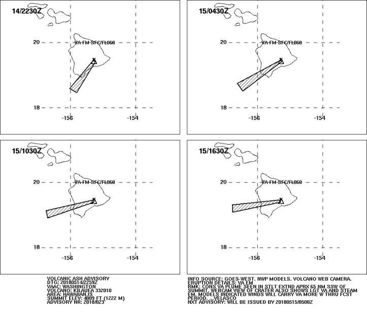
May 14, 2018, 4:43 p.m.: Apparently there is enough ash mixed in with the gas/steam plume from the summit to warrant another VAAC notice. Here’s the current graphic:
Current webcam image:
Meanwhile, NASA is studying the East Rift eruption plume from space. (h/t Dr. Janine Krippner)
May 14, 2018, 5:20 p.m.: Update:
May 18, 2018, 7:55 p.m.: Hawaii County CD just issued a Condition Red for SO2 in southeast Lanipuna Gardens.
May 14, 2018, 8:19 p.m.: I wonder if the “hotter, fresher” stuff from the summit and Pu’u O’o is reaching the surface now.
#LeilaniEstatesEruption LATEST: @CivilDefenseHI says lava now about 1.3 miles from Hwy137 (Old Government Beach Rd./WaaWaa Rd.) as officials confirm three wells on Puna Geothermal Venture plant are still active & need to be capped https://t.co/VKjPIs19gA @HawaiiNewsNow #HINews pic.twitter.com/t0sOcRjFKD
— Mileka Lincoln (@MilekaLincoln) May 15, 2018
https://platform.twitter.com/widgets.js
May 14, 2018, 10:11 Pacific: About a half-hour ago, Washington VAAC put out a brief advisory that Kilauea is still venting light ash at the summit. No graphics, just confirmation of continuing activity of the sort that Dr. O’Neal described in her update earlier (see video lower down in today’s posts).
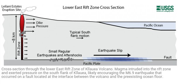
May 14, 2018, 11:31 p.m. Pacific: HVO addressed the issue of stability of Kilauea’s southern flank in terms of the M6.9 quake last week. It’s worth including the whole article:
Facts on the stability of Kilauea’s south flank, past and present.
May 14, 2018
There have been several recent highly speculative stories, rumors and blogs about the stability of the south flank of Kīlauea and the potential for a catastrophic collapse that could generate a Pacific-wide tsunami. We wish to put these speculations in their proper context by presenting observations of the current situation and an assessment of past evidence of landslides from Kīlauea.
There is no geologic evidence for past catastrophic collapses of Kīlauea Volcano that would lead to a major Pacific tsunami, and such an event is extremely unlikely in the future based on monitoring of surface deformation. Kīlauea tends to “slump”, which is a slower type of movement that is not associated with tsunamis, although localized tsunamis only affecting the island have been generated by strong earthquakes in the past.
The May 4 M6.9 earthquake resulted in seaward motion of approximately 0.5 m (1.5 ft) along portions of Kīlauea’s south flank as measured by GPS stations across the volcano. A preliminary model suggests that the motion was caused by up to 2.5 meters (8 feet) of slip along the fault that underlies the volcano’s south flank, at the interface between the volcano and the ocean floor, about 7-9 km (4-6 mi) beneath the surface. This motion is within the expected range for a large earthquake on this fault. The earthquake was probably caused by pressure exerted by the magmatic intrusion on the south flank fault, following the pattern of past earthquake activity that has been observed during Kīlauea East Rift Zone intrusions. A small, very localized tsunami did occur as a result of the fault slip. Similar local tsunamis were generated by past large earthquakes, including the 1975 M7.7 and 1868 ~M8 events, both of which resulted in multiple deaths along the south coast of the Island of Hawaii.
Adjustments on the south flank caused another ~9 cm (3.5 inches) of motion at the surface in the day after the earthquake, followed by another 2-3 cm (~1 inch) since May 5. This is higher than the normal rate of south flank motion (~8 cm (3 inches) per year) but is expected as the volcano adjusts after a combination of a magmatic intrusion along the East Rift Zone and a large south flank earthquake. We did observe minor ground ruptures on the south flank, but this is expected given the strength of the May 4 earthquake, and deformation data show that the south flank continues to move as an intact slump block.
Geologic history combined with models of south flank motion suggest that the likelihood of a catastrophic failure event is incredibly remote. There are certainly signs on the ocean floor for landslides from other volcanoes on the Island of Hawaii and from other islands, but none are associated with Kīlauea. In addition, Kīlauea has experienced much larger earthquakes and magmatic intrusions in the recent past. The large earthquakes of 1975 and 1868 were not associated with significant south flank landsliding, nor were major East Rift Zone intrusions in 1840 and 1924.
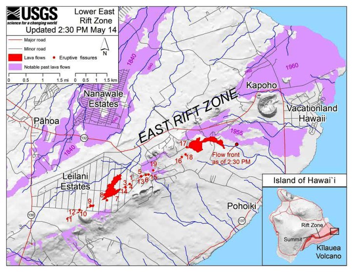
May 14, 2018, 11:49 p.m. Pacific: The USGS has eruption site maps online. (h/t to NWS Honolulu)
Here is today’s as of 2:30 p.m. HST:
Those flows from #17 will have extended a ways by tomorrow, judging by this video:
#LeilaniEstatesEruption UPDATE: Residents say fissure 17 is firing tonight. USGS HVO scientists say of all 19 fissures — the 17th, located off of Halekamahina Loop Road west of Highway 132 on the Kalapana side, is the most active and largest https://t.co/HN7Ea6kSjw @HawaiiNewsNow pic.twitter.com/g67tYLHtLy
— Mileka Lincoln (@MilekaLincoln) May 15, 2018
https://platform.twitter.com/widgets.js
No wonder there is an SO2 inundation in southeast Lanipuna Gardens and the nearby feed lots. Haven’t been able to find any news online about evacuations or casualties in that area, so hopefully people are handling this air-quality Code Red all right tonight. Best wishes, and stay safe!
May 15, 201, 9:50 a.m. Pacific: Video from about this time yesterday:
All the news is a bit overwhelming. It took a while for this to sink in, even though they mention it in the Hawaii County alert (below):
New fissure has opened in Lanipuna Gardens N.E. from fissure 19. No homes or roads threatened at this time.
— COH Civil Defense (@CivilDefenseHI) May 15, 2018
https://platform.twitter.com/widgets.js
Per Hawaii County:
This is a Civil Defense Message for Tuesday, May 15 at 6:00 AM in the morning.
Hawaiian Volcano Observatory reports a new fissure has opened in the Lanipuna Gardens Subdivision northeast from fissure 19. The narrow lava flow from fissure 17 is still moving slowly toward the ocean at approximately 20 yards per hour. There are no homes or roads threatened at this time. For up to date information go to http://www.hawaiicounty.gov/2018-lava-map.
Due to the volcanic activity, the following are issued:
The Hawaii Department of Transportation (HDOT) is working to reopen the Keaau-Pahoa Road (Highway 130) from Malama Street to Kamaili Road this morning for local traffic only. [10:24 a.m. Pacific: Plan reportedly canceled because new cracks have appeared there–BJD] Motorists are advised to drive with caution as metal plates will be placed over the cracks on the roadway. HDOT and County personnel will be stationed along the route to ensure the roadway is safe for local traffic.
Dept. of Health reports hazardous emissions of sulfur dioxide (SO2) gas from fissures are especially dangerous for elderly, children/babies and people with respiratory problems. SO2 can be carried with wind, or, cover an area with no wind.
Residents of Lower Puna are advised to be on the alert to gas emissions.
Highway 132 is closed at Pohoiki Road intersection and a checkpoint is located on Highway 130 by Pahoa High School. Only local traffic allowed beyond all roadblocks.
The residents of Puna are going through a very difficult time. We ask for your help and understanding.County, State and Federal partners continue to monitor the situation. You will be informed of any conditions that affect your safety.
Per KHNL, residents near Fissure 17 say it sounded like a war zone overnight.
From the same source, the flow has moved at least two miles so far and could compromise Highway 132, cutting off one of the only two exits out of the Kapoho and Kalapana areas. The other route is unpaved in some areas. At least three fissures are active and over 500 people spent the night in Red Cross shelters.
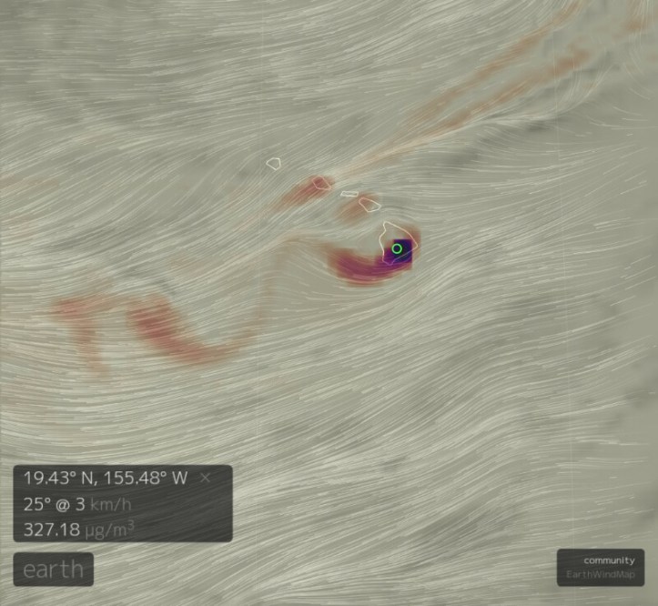
That’s what the winds and SO2 look like around Hawaii, per a forecast-model site I found this morning.
If the models are correct, it looks like tomorrow, particularly in the afternoon, may be very unpleasant on the Big Island — check out the National Weather Service for more accurate information.
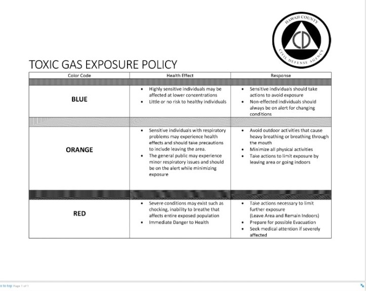
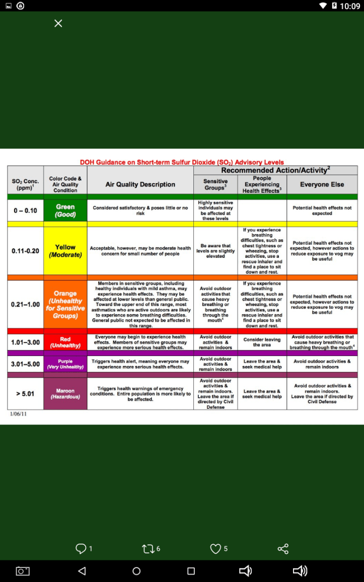
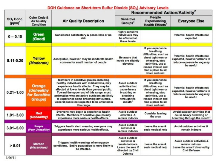
Again, here is the air quality code system–note that there can be levels worse than the Code Red that the Hawaii Fire Department alerted residents to last night in southeast Lanipuna Gardens and nearby feedlots.
Today they’re planning to kill three geothermal wells at the Puna Geothermal Venture site. Apparently that’s something you can do. Last week during his press conference, Governor Ige mentioned a concern that lava could cause a blowout, though it wasn’t clear what would happen if there was contact between the active flow and the well. They are not taking any chances, apparently.
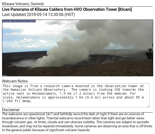
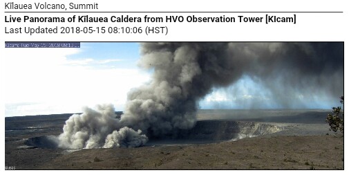
At Kilauea’s summit, things look ashy through the webcam at present:
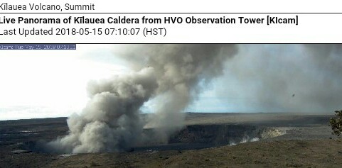
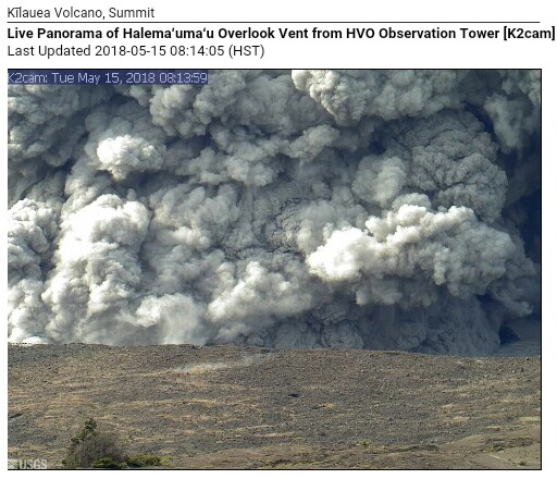
May 15, 2018, 10:53 a.m.: Summit crater webcam views:
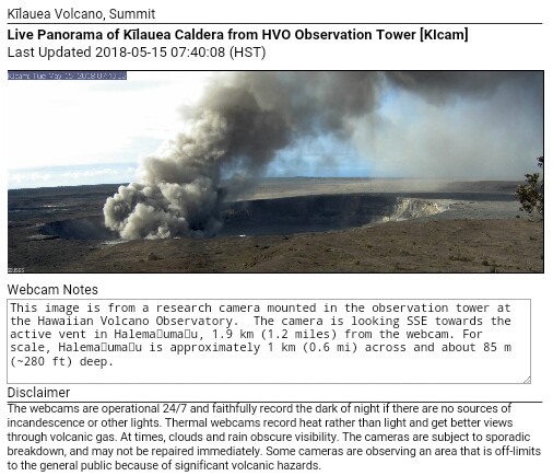
Closer view:
Special weather statement from National Weather Service, Honolulu:
Special Weather Statement
National Weather Service Honolulu HI
754 AM HST Tue May 15 2018HIZ024-160000-
South Big Island-
754 AM HST Tue May 15 2018…VERY LIGHT ASHFALL AND HAZARDOUS AIR QUALITY THROUGH EARLY
AFTERNOON…The web camera at Kilauea Volcano Summit at showed a burst in
volcanic ash emissions from Halemaumau Crater (19.4N 155.3W)
beginning around 7 am HST this morning. Northeast winds will
carry ash downstream across the Big Island Kau District affecting
the Punaluu, Wood Valley, Naalehu communities this morning and
into early afternoon.Avoid excessive exposure to ash which is an eye and respiratory
irritant. Those with respiratory sensitivities should take extra
precaution to minimize exposure.$$
Foster
“Just” a burst – crater activity looks like it’s calming down now.
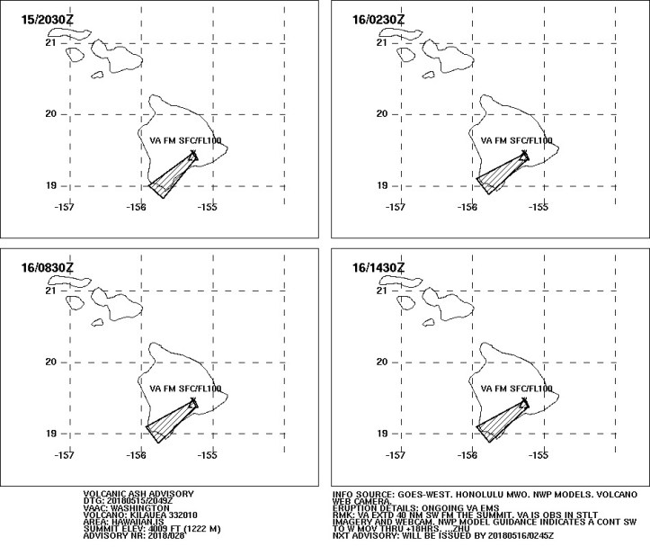
May 15, 2018, 11:48 a.m. Pacific: Latest VAAC advisory here. And the graphic:

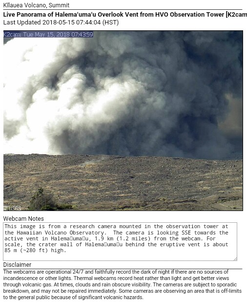
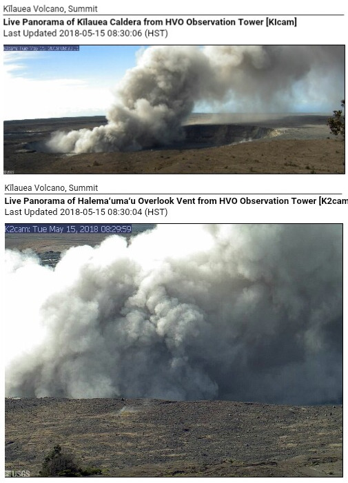
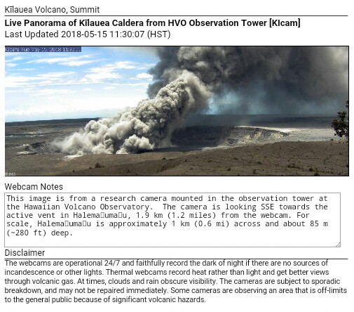
May 18, 2018, 12:21 p.m. Pacific: Still awaiting word from HVO on this morning’s summit activity (and the new vent that opened in Lanipuna Gardens). In the meantime, Halema’uma’u looks more like a volcanic vent this morning than a fumarole:
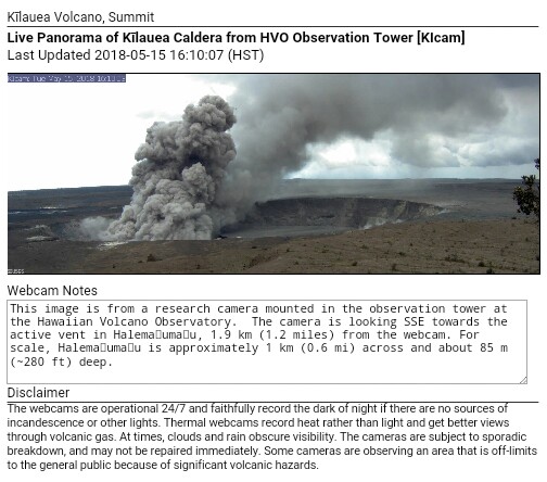
May 18 15, 2018, 2:38 p.m.: Two updates online from HVO, and ongoing activity in the crater via the webcam:
Parts of the Ka’u District are getting ashed.
Eruption Update for May 15 at 1000. HVO reports rock falls and gas explosions within Halemaumau Crater have caused an ash plume, which is carrying ash downstream across Ka'u District. Ash is being reported along Highway 11 in Pahala. #mayorharrykim https://t.co/ieBgjTtIqY
— Mayor Harry Kim (@MayorHarryKim) May 15, 2018
https://platform.twitter.com/widgets.js
Graphic from the latest VAAC advisory (2049 UTC):
Na Leo is broadcasting on Channel 55 the daily media teleconferences hosted by HVO. Also online at https://t.co/n7NgLT0C5e, rebroadcast times for today, May 15th: 12:30PM, 3:00PM, 5:30PM, & 8:00PM. Mahalo plenty to Na Leo TV
— Mayor Harry Kim (@MayorHarryKim) May 15, 2018
https://platform.twitter.com/widgets.js
May 15, 2018, 3:10 p.m.: Words of wisdom if you’re getting ash fall and need to travel:
Volcanic ash can make roads slick and reduce visibility. Ash is also harmful to vehicles. Be careful.
Learn more: https://t.co/SHI2IWdptg #Kilauea https://t.co/z8mVSqECNk— Dr Janine Krippner (@janinekrippner) May 15, 2018
https://platform.twitter.com/widgets.js
If you find yourself under ashfall around #Kilauea, the recommended face mask is N-95 to protect your airways & also protect your eyes (goggles). Contacts lenses are not good. We all know what an eyelash in the eye feels like.
More info here: https://t.co/JtHh2GRPW6 pic.twitter.com/LikpjFGIr6— Dr Janine Krippner (@janinekrippner) May 15, 2018
https://platform.twitter.com/widgets.js
May 15, 2018, 3:54 Pacific: Listened to a rebroadcast on Na Leo TV of the 11 a.m. press conference with USGS and NOAA personnel. Some good news. Dr. Steve Brantley said that activity is diminished a bit in the fissure zone, including fissure #17 (which he called 18 – there is still that naming confusion, I guess; it’s the big fountaining one, anyway). It only moved about 1200 feet in the last day. He also says that it appers on instruments that the intrusion is continuing underground but quakes have not continued to move downrift yet.
Per the NOAA expert (whose name I didn’t quite catch), the trade winds will weaken some today and more tomorrow, so there will probably be some ash and gas traveling more inland. Later in the week, the trade winds are expected to pick up again.
And starting Sunday, parts of Hawaii Volcanoes National Park will be open from Wednesday through Sunday.
Per a new USGS update, only a little lava has come out of the new fissure that opened this morning. Also they say the #17 lava flow has traveled just about 2.5 miles, a little less than was reported earlier. As per the media report above, activity has slowed down in the fissure eruption.
May 15, 2018, 4:47 p.m. Pacific: Because of today’s ash emission at Halema’uma’u, they have upgraded Kilauea’s status to a red warning:
HVO/USGS Volcanic Activity Notice
Volcano: Kilauea (VNUM #332010)
Current Volcano Alert Level: WARNING
Current Aviation Color Code: RED
Previous Aviation Color Code: ORANGEIssued: Tuesday, May 15, 2018, 1:23 PM HST
Source: Hawaiian Volcano Observatory
Notice Number:
Location: N 19 deg 25 min W 155 deg 17 min
Elevation: 4091 ft (1247 m)
Area: HawaiiVolcanic Activity Summary: As of early this morning, eruption of ash from the Overlook vent within Halemaumau crater at Kilauea Volcano’s summit has generally increased in intensity. Ash has been rising nearly continuously from the vent and drifting downwind to the southwest. Ashfall and vog (volcanic air pollution) has been reported in Pahala, about 18 miles downwind. NWS radar and pilot reports indicate the top of the ash cloud is as high as 10,000 to 12,000 feet above sea level, but this may be expected to vary depending on the vigor of activity and wind conditions.
Ash emission from the Kilauea summit vent will likely be variable with periods of increased and decreased intensity depending on the occurrence of rockfalls into the vent and other changes within the vent.
At any time, activity may become more explosive, increasing the intensity of ash production and producing ballistic projectiles near the vent.
Resource on volcanic ash hazards: https://volcanoes.usgs.gov/volcanic_ash/
Resource on vog: https://vog.ivhhn.org/
Recent Observations:
[Volcanic cloud height] 10,000 – 12,000 feet
[Other volcanic cloud information] Drifting generally southwest with tradewinds.Hazard Analysis:
[Ash cloud] The ashcloud is drifting downwind primarily to the southwest with the Trade Winds. Wind conditions are expected to change in the next 24 hours and other areas around Kilauea’s summit are likely to receive ashfall.
[Ashfall] Ashfall has been reported in the community of Pahala, at locations along Highway 11 from Pahala to Volcano, and in the Ka’u Desert section of Hawaii Volcanoes National Park.
[Other hazards] Ballistic projectiles may be produced should steam-driven explosions occur. Impacts will be limited to an area around Halemaumau.
[Volcanic gas] Vog or volcanic air pollution produced by volcanic gas has been reported in Pahala.Remarks: Photos of this activity may be found here:
https://volcanoes.usgs.gov/volcanoes/kilauea/kilauea_multimedia_15.html
Contacts: askHVO@usgs.gov
Next Notice: Additional notices will be issued should activity change significantly.
Consult the National Weather Service for specific Ashfall notifications:http://www.prh.noaa.gov/hnl/
What does the new #HVO #Kilauea VAN/VONA mean? Here are the #USGS criteria for alert levels: https://t.co/f7KUtO78bP #KilaueaErupts pic.twitter.com/ZXndsbaLW6
— USGS Volcanoes🌋 (@USGSVolcanoes) May 15, 2018
https://platform.twitter.com/widgets.js
Earlier today it was announced that the Puna Geothermal Plant’s three remaining active wells are being “killed” – that is, filled with cold water – and then they will be plugged. This is to prevent blowouts and leakage of hydrogen sulfide.
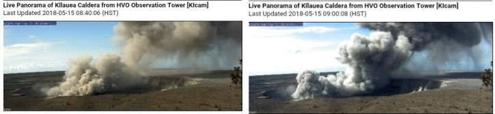
May 15, 2018, 5:11 p.m.: Activity on the webcam is actually somewhat less than earlier today, at least for the moment. NWS has issued an ashfall advisory:
URGENT – WEATHER MESSAGE
National Weather Service Honolulu HI
109 PM HST Tue May 15 2018…ASHFALL ADVISORY POSTED FOR KAU DISTRICT OF BIG ISLAND…
.Halemaumau Crater at the Kilauea Volcano continues to produce
significant amounts of ash in the emissions resulting in ashfall
occurring over the Kau District on the Big Island.HIZ024-160400-
/O.NEW.PHFO.AF.Y.0001.180515T2309Z-180516T0400Z/
South Big Island-
109 PM HST Tue May 15 2018…ASHFALL ADVISORY IN EFFECT UNTIL 6 PM HST THIS EVENING…
The National Weather Service in Honolulu has issued an Ashfall
Advisory, which is in effect until 6 PM HST this evening.* ERUPTION…Kilauea Volcano Summit (19.4N 155.3W) at 100 PM HST.
* LOCATION…Volcanic ash is expected to reach the surface to the
southwest of the Kilauea Volcano Summit (Halemaumau Crater),
including cities of Wood Valley, Pahala, Punaluu, Naalehu, and
Hawaiian Oceanview Estates.* IMPACTS…Possible harm to crops and animals. Minor equipment
and infrastructure damage. Widespread cleanup may be necessary.PRECAUTIONARY/PREPAREDNESS ACTIONS…
An Ashfall Advisory means that large amounts of ash will be
deposited in the advisory area. Persons with respiratory illnesses
should remain indoors to avoid inhaling the ash particles and all
persons outside should cover their mouth and nose with a mask or
cloth. For health and safety recommendations, please visit the
Hawaii Interagency Vog Information Dashboard at https://vog.ivhhn.org&&
$$
Foster
May 15, 2018, 5:17 p.m.: Meanwhile, in the East Rift Zone, there actually may be two new fissures today, 20 and 21, per this update from very early today before things ramped up in the summit–they’re still working out the fissure count.
CD 5/15, 1pm: Ash fall Hwy 11 to Pahala. Fissure 17 only active flow. HDOT:Hwy 130 expected to open in afternoon. Air quality condition RED.
— COH Civil Defense (@CivilDefenseHI) May 15, 2018
https://platform.twitter.com/widgets.js
May 15, 2018, 6:27 p.m. Pacific: The spectacle is fascinating, but sightseeing brings problems of its own:
Most of Hawai‘i Volcanoes remains closed due to ongoing seismic activity, summit deflation, and a possible steam explosion at Kīlauea's summit. Do not stop on Hwy 11 in the park unless it's an emergency. Vehicles & pedestrians are creating a hazard. https://t.co/x6H7IXwxJJ
— Hawaii Volcanoes NPS (@Volcanoes_NPS) May 16, 2018
https://platform.twitter.com/widgets.js
May 15, 2018, 7:32 p.m. Pacific: Latest VAAC notice said that less volcanic ash was seen in the webcam. Exactly 15 minutes later (i.e., around right now):
This could go on now for days, weeks, or months. The lava lake was there for years. Volcanology is a tough science, and living with this is also hard on the people of Hawaii and those who travel nearby.
I hope it wraps up soon. But it is what it is, and humankind will just have to deal with that.
The official count down in the East Rift is now 21 fissures. I have read that 24 opened up in 1955. Will see how this goes. The good news is that they announced during the mid-day media conference that the fissure eruptions have slowed down a bit. Even voluminous fissure 17, which “only” advanced some 1200 feet over 24 hours.
May 15, 2018, 9:47 p.m. Pacific: Fissure #6 reactivated, Hawaii County CD tweeted about 45 minutes ago.
Comparison Photos: 1924 #Halemaumau Crater/Vent Eruption vs. Current Tuesday, May 15, 2018 #Rockfall/#AshPlume Event! #DownWind #AshFall IS THE PROBLEM!!! #KilaueaErupts #KilaueaEruption #Kilauea #Volcano #BigIsland #Hawaii pic.twitter.com/cuIIoqQTL6
— The View Master! (@AlohaEvery1) May 16, 2018
https://platform.twitter.com/widgets.js
May 16, 2018, 1331 UTC: The editors of a website that has accepted some of my articles on Kilauea prefer to use UTC, and it is easier to use when covering an event in other time zones, so I’ll use it from now on.
Excellent image from a Civil Air Patrol flight yesterday:
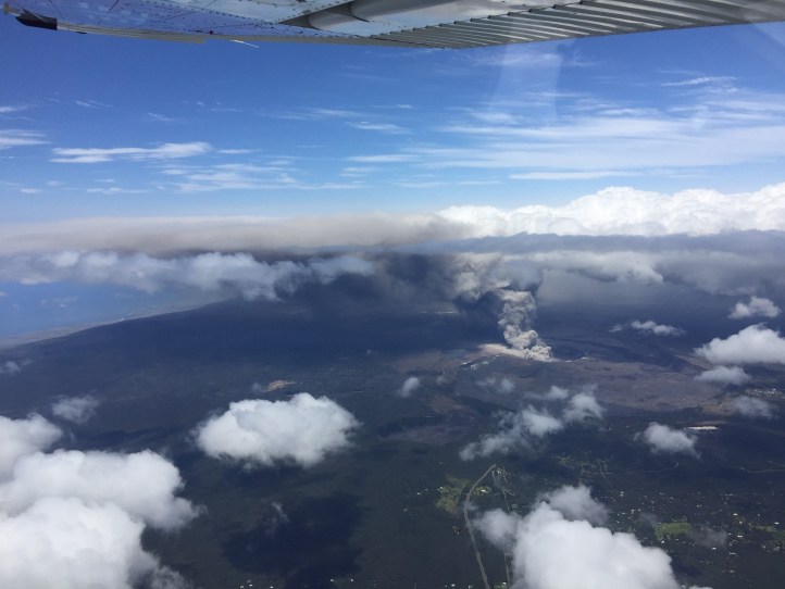
NWS Honololu still has the area under an ashfall alert until 1800 UTC today. The last Washington VAAC advisory, from 0803 UTC, says hotspots were visble by satellite but not ash, although there may be ongoing emission. Webcams, of course, are dark right now.
Per KHNL, two small fissures opened up in Lanipuna Gardens yesterday, bringing the total up to 21.
Here is some video that was tweeted about five hours. It’s no longer live, but if you check it out it’s cool to hear the night tree frogs and the lava. Not sure, but think it’s fissure #17, whose activity has diminished despite what the tweet says.
Live now at the Kilauea Volcano where activity has increased over the last 24 hours.
Stream: https://t.co/JE0gHQ8iN1 pic.twitter.com/EFb7OpIHWU
— WeatherNation (@WeatherNation) May 16, 2018
https://platform.twitter.com/widgets.js
May 16 17, 2018, 0048 UTC: Good update from KHNL here. Good USGS overview portal here.
And this just in from HVO (note: I think they mean overall three feet, not that it dropped three feet today):
HAWAIIAN VOLCANO OBSERVATORY INFORMATION STATEMENT
U.S. Geological Survey
Wednesday, May 16, 2018, 2:35 PM HST (Thursday, May 17, 2018, 00:35 UTC)KILAUEA VOLCANO (VNUM #332010)
19°25’16” N 155°17’13” W, Summit Elevation 4091 ft (1247 m)
Current Volcano Alert Level: WARNING
Current Aviation Color Code: REDKĪLAUEA INFORMATION STATEMENT
Strong earthquakes within the summit of Kīlauea Volcano continue in response to ongoing deflation and lava column drop. As of the afternoon of May 16, the floor of Kīlauea caldera has dropped approximately 3 feet (90 cm). This movement is stressing faults around the caldera of Kilauea, causing them to move and resulting in strong earthquakes of up to magnitude 4.4 thus far.
Employees at the Hawaiian Volcano Observatory, Hawai`i Volcanoes National Park and nearby residents are reporting frequent ground shaking and damage to roads and buildings. Hawaii County Police reports cracks across Highway 11 between mile markers 28 and 29. Although these are passable, motorists are urged to use caution.
As deflation continues, strong earthquakes in the area around Kilauea Volcano’s summit are expected to continue and may become more frequent. Areas further from these earthquakes may feel some ground motion as well, but much less severe.
The shallow depths of these earthquakes make them more damaging in the immediate vicinity of the epicenter, and individuals need to take precautions to minimize damage from the shaking, including the removal of unstable items from walls and shelves. Steep slopes should be avoided as they may become destabilized during strong earthquakes.
Video updates from earlier today:
HVO/USGS daily update on the eruption:
May 17, 2018, 0328 UTC:
Employees at the Hawaiian Volcano Observatory, Hawai`i Volcanoes National Park & nearby residents are reporting frequent ground shaking and damage to roads and buildings. Hawaii County Police reports cracks across Highway 11 between mile markers 28 & 29, reports @USGSVolcanoes
— David Begnaud (@DavidBegnaud) May 17, 2018
https://platform.twitter.com/widgets.js
NWS has also issued another special weather statement about light ashfall and hazardous air quality.
May 17, 2018, 0527 UTC: Apparently everything is still holding.
This video is of a USGS overflight of the fissure zone. Not surprising that it’s a no-go area now!
A portion of Leilani Estates and all of Lanipuna Gardens has been designated as a no-entry zone for its crews. These areas are hazardous to enter due to continued ground swelling and cracking, sudden fissure activity, and unsafe levels of sulfur dioxide. https://t.co/NOWosyK2wn pic.twitter.com/v89WvmoQJ0
— HawaiiElectricLight (@HIElectricLight) May 17, 2018
https://platform.twitter.com/widgets.js
Webcam shot now:
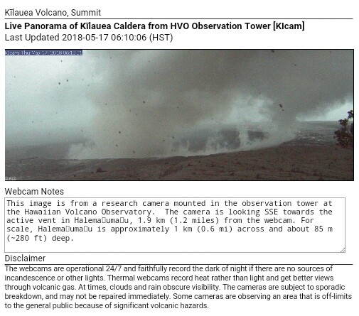
May 17, 2018, 1610 UTC: Looks like the first of the big ones has happened. Washington VAAC reported at 1548 an ash plume up to 300,000 30,000 feet. It was easier to see on radar than satellite imagery, per the notice, and activity has dropped since then.
And apparently the Big Island is in for at least some of it, per the advisory graphic:
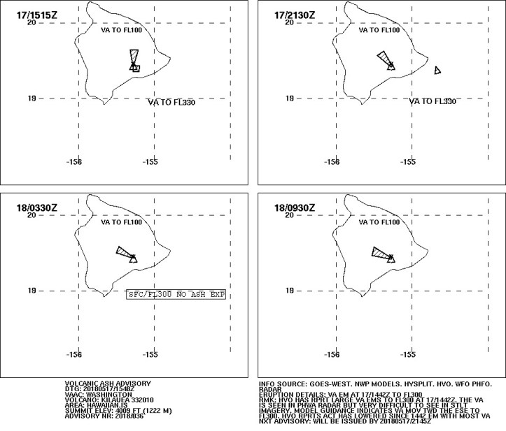
An ashfall advisory is in effect:
URGENT – WEATHER MESSAGE…CORRECTED
National Weather Service Honolulu HI
605 AM HST Thu May 17 2018…ASHFALL ADVISORY IN EFFECT FOR KAU DISTRICT OF BIG ISLAND…
HIZ024-172200-
/O.COR.PHFO.AF.Y.0002.000000T0000Z-180517T2200Z/
South Big Island-
605 AM HST Thu May 17 2018…ASHFALL ADVISORY IN EFFECT UNTIL 12 PM HST TODAY…
The National Weather Service in Honolulu has issued an Ashfall
Advisory, which is in effect until 12 PM HST today.* ERUPTION…Kilauea Volcano Summit (19.4N 155.3W) approximately
400 AM HST. Radar estimates the height of the plume around
30,000 feet.* LOCATION…Volcanic ash is expected to reach immediate vicinity
of the Kilauea Volcano Summit (Halemaumau Crater), including
Volcano and Glenwood.* TIMING…This advisory may need to be extended if volcanic
ashfall emissions persist.* IMPACTS…Due to the sustained but low-level nature of ash
production from Halemaumau Crater, ash accumulation less than
one quarter of an inch is possible over the advisory area. Eye
and respiratory irritants with low level impacts for most
people.PRECAUTIONARY/PREPAREDNESS ACTIONS…
For more information on the status of Kilauea Volcano, please see
https://volcanoes.usgs.gov/volcanoes/kilauea/status.htmlPersons with respiratory illnesses should remain indoors to avoid
inhaling the ash particles and all persons outside should cover
their mouth and nose with a mask or cloth. For health and safety
recommendations, please visit the Hawaii Interagency Vog
Information Dashboard at https://vog.ivhhn.org
&&$$
RCB
5 AM eye-opener at the the Kīlauea Volcano summit. HVO and Park Staffs previously evacuated. Lone webcam in the HVO Tower shows the plume. https://t.co/GVg72Rc51N pic.twitter.com/RBUbYa39rP
— USGS Volcanoes🌋 (@USGSVolcanoes) May 17, 2018
https://platform.twitter.com/widgets.js
Warning from @CivilDefenseHI that an explosive eruption has occurred at #Kilauea. Ash plume expected to spread to SE. Driving conditions may be dangerous. Shelter in place if you can.
— Hawaii EMA (@Hawaii_EMA) May 17, 2018
https://platform.twitter.com/widgets.js
Here is the latest marine ashfall advisor. You can check them out here.

Another good information portal.
May 18, 2018, 0129 UTC: Here is the USGS video update from this morning:
And here are excerpts from the 2100 UTC media conference call on May 17 (the whole thing is available here); there’s some cool video of the eruption from other USGS monitoring cameras in this:
Fortunately it was a very brief event and the effects, other than very light ashfall and vog, weren’t widespread. That’s good because the trade winds are so weak just now.
The National Weather Service just has a special weather statement up now.
There hasn’t been another summit explosion, just low-level gas and ash emissions. Washington VAAC issued one more advisory at 2115 on the 17th just so everybody knows what’s going on, and here is the graphic for that:
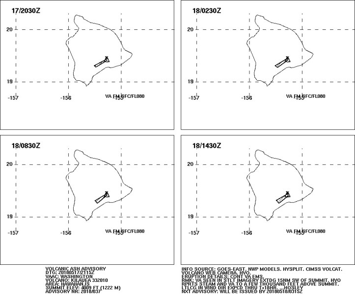
From USGS tweets, apparently the HVO website went offline from so much traffic right after the explosion. It’s back up, and the USGS and National Weather Service have an information website available, too.
Regarding the fissures, an HVO update at 2040 UTC reported that there was low-level activity at multiple points along the northeast end, with spattering from Fissure #17 but no significant lava flow advance. Deformation of the ground and elevated seismicity continue.
They said they are doing overlights, looking for structural changes in the vent, and keeping an eye out for signs of new or resumed activity.
There are some excellent images from USGS here, as well as this overflight video from yesterday that Mick Kalber shared:
Finally, someone has put together a list of the latest updates from his sources. Check it out!
May 18, 2018, 0206 UTC: Volcano emergencies just go on and on and on — it’s very different from a severe weather event!
#LeilaniEstatesEruption UPDATE: @CivilDefenseHI says lava flow from fissure 17 appears to have stalled, but all 20 fissures are de-gassing leading to extremely high sulfur dioxide levels across Puna; LOCATIONS👉🏽 https://t.co/Wa0rmlJvtD @HawaiiNewsNow (Video: @ShaneVictorino) pic.twitter.com/Tdt7BHKR82
— Mileka Lincoln (@MilekaLincoln) May 18, 2018
https://platform.twitter.com/widgets.js
May 18, 2018, 0246 UTC: Uh-oh:
Thurs 5/17 4:30PM Several fissures reactivated with pahoehoe lava flows, residents be aware of new activity near Makamae St (Leilani Est)
— COH Civil Defense (@CivilDefenseHI) May 18, 2018
https://platform.twitter.com/widgets.js
Per KHNL, a 21st fissure has opened and several old vents have reactivated. Vog is really bad in Puna, still.
May 18, 2018, 0323 UTC: Just in:
HAWAIIAN VOLCANO OBSERVATORY STATUS REPORT
U.S. Geological Survey
Thursday, May 17, 2018, 4:54 PM HST (Friday, May 18, 2018, 02:54 UTC)KILAUEA VOLCANO (VNUM #332010)
19°25’16” N 155°17’13” W, Summit Elevation 4091 ft (1247 m)
Current Volcano Alert Level: WARNING
Current Aviation Color Code: RED,Kīlauea Volcano Summit [sic]
After the explosive eruption early this morning seismic levels have been gradually increasing, but as of this report no additional explosions have occurred.
No earthquakes greater than magnitude 3.5 have occurred in the past day.
Volcanic gas emissions at the summit remain high.
Kīlauea Lower East Rift Zone
This afternoon, fissure 17 is still actively spattering but the flow is nearly stalled. In addition, fissures 18, 19, and 20 have reactivated and a new fissure (21) has opened between fissures 7 and 3. An area 50-100 yards wide, parallel to and north of the line of fissures between Highway 130 and Lanipuna Gardens, has dropped slightly. This long depression is currently being filled by pahoehoe lava flows from fissures 20 and 21.
Volcanic gas emissions remain elevated throughout the area downwind of the fissures.
Magma continues to be supplied to the lower East Rift Zone as indicated by the continued northwest displacement of a GPS monitoring station. Elevated earthquake activity continues, but earthquake locations have not moved farther downrift in the past couple of days.
USGS/HVO continues to monitor the lower East Rift Zone activity 24/7 in coordination with Hawaii County Civil Defense, with geologists onsite to track ongoing and new fissure activity and the advance of lava flows.
MORE INFORMATION
Activity Summary also available by phone: (808) 967-8862
Subscribe to these messages: https://volcanoes.usgs.gov/vns2/
Webcam images: https://volcanoes.usgs.gov/volcanoes/kilauea/multimedia_webcams.html
Photos/Video: https://volcanoes.usgs.gov/volcanoes/kilauea/multimedia_chronology.html
Lava Flow Maps: https://volcanoes.usgs.gov/volcanoes/kilauea/multimedia_maps.html
Definitions of terms used in update: https://volcanoes.usgs.gov/volcanoes/kilauea/extra/definitions.pdf
Overview of Kīlauea summit (Halemaʻumaʻu) and East Rift Zone (Puʻu ʻŌʻō ) eruptions:
https://volcanoes.usgs.gov/volcanoes/kilauea/extra/background.pdfSummary of volcanic hazards from Kīlauea eruptions:
https://volcanoes.usgs.gov/volcanoes/kilauea/extra/hazards.pdfRecent Earthquakes in Hawai’i (map and list):
https://volcanoes.usgs.gov/hvo/earthquakes/Explanation of Volcano Alert Levels and Aviation Color Codes:
https://volcanoes.usgs.gov/activity/alertsystem/index.php
https://pubs.usgs.gov/fs/2006/3139/CONTACT INFORMATION:
askHVO@usgs.gov
The Hawaiian Volcano Observatory is one of five volcano observatories within the U.S. Geological Survey and is responsible for monitoring volcanoes and earthquakes in Hawai`i.
You have received this email because you have subscribed to the USGS VNS.
To change your parameters, or unsubscribe from the service, go to https://volcanoes.usgs.gov/vns/
Vog, bad stuff. Current view from one of the HVO webcams:
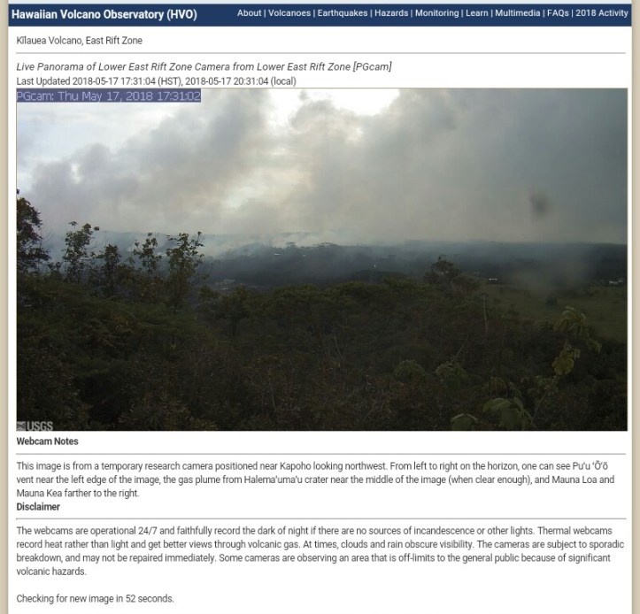
May 17, 2018, 0456 UTC: [I think this was the 18th, but I’m keeping it as in the live-blog — Barb]
#LeilaniEstatesEruption UPDATE: This is the crack on Nohea Street that officials have been monitoring; I’m told 40 yds of the street has sunk about 10 ft; @CivilDefenseHI confirms a 21st fissure broke out down rift of Makamae St. https://t.co/AXRgqkgi78 @HawaiiNewsNow #HINews pic.twitter.com/iXaVeQHIUE
— Mileka Lincoln (@MilekaLincoln) May 18, 2018
https://platform.twitter.com/widgets.js
May 18, 2018, 0525 UTC: At night this cam is usually black except for a few street lights in the distance. This is sad – the new activity must be intense; I think that’s the reactivated fissures, and the new 21st one is more to the left, off screen?
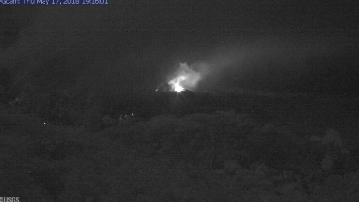
May 18, 2018, 1533 UTC: You can finally see a lava flow on the USGS webcams here.
Unfortunately, it’s headed for those lights in the foreground, which I think are from the Puna geothermal plant.
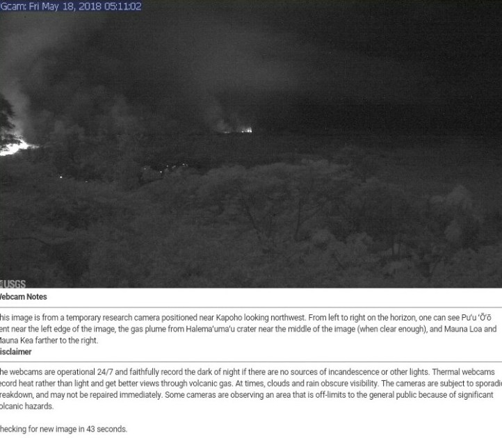
The text below the camera image might not match up with this cam; it is from the earlier cam setup before the fissures opened and they installed this mobile cam (it’s mentioned down below, I forget which date).
At first I thought the lack of online references to the new lava flow meant I was wrong, but it occurs to me now that perhaps I’m right and people just don’t want to make a big fuss about it. There’s still an ongoing attempt at capping the three wells there that are still active, per KHNL last night. Concerns are of a blast with resulting gases and hazardous material; however, the plant has been controversial since its beginning back in the 90s, and I don’t know how much of that concern today has a basis. It has had some problems down through the years, and the governor expressed concern last week, so there is some basis, but apparently there is no need for panic.
From what I understand from the recent interview on May 14th with Tom Travis, they need to first cool the well down (“kill” it) and then plug it, before the lava rolls in.
Probably the big thing isn’t so much the possibility of a pending blowout, though that is certainly serious–rather, it’s that nobody knows what’s going to happen. As I understand from documents at the University of Hawaii’s online collection from the 90s, when the plant was getting started, Puna Geothermal Ventures was the first such plant in a hot spot zone like Hawaii (which is a different geologic sitting from Iceland, where such ventures have operated right through eruptions sometimes, though with damage). Ever. I haven’t looked to see if other operations might be around today.
If Civil Defense is doing anything extra over Puna, it hasn’t appeared online yet. I think if there was a serious hazard from the plant right now, it would appear there. This emergency response is amazing. Let’s assume that there is no more hazard now than there has been throughout this horrible disaster for the Puna Distrct from the East Rift fissure eruptions.
These are ongoing by the way. I think the glow last night (see last night’s post) was from fissure #17 because of this —
#LeilaniEstatesEruption LATEST: Fissure 17 near Halekamahina Lp Rd is extremely active tonight even though the 2 mile lava flow produced by it has appeared to stall for now, according to USGS; #FBLIVE 👉🏽https://t.co/CLWVHwpJ1F @HawaiiNewsNow #HINews #HawaiiNews #KilaueaVolcano pic.twitter.com/dgzMr6Yd7V
— Mileka Lincoln (@MilekaLincoln) May 18, 2018
https://platform.twitter.com/widgets.js
From the webcam last night, it looked like this:
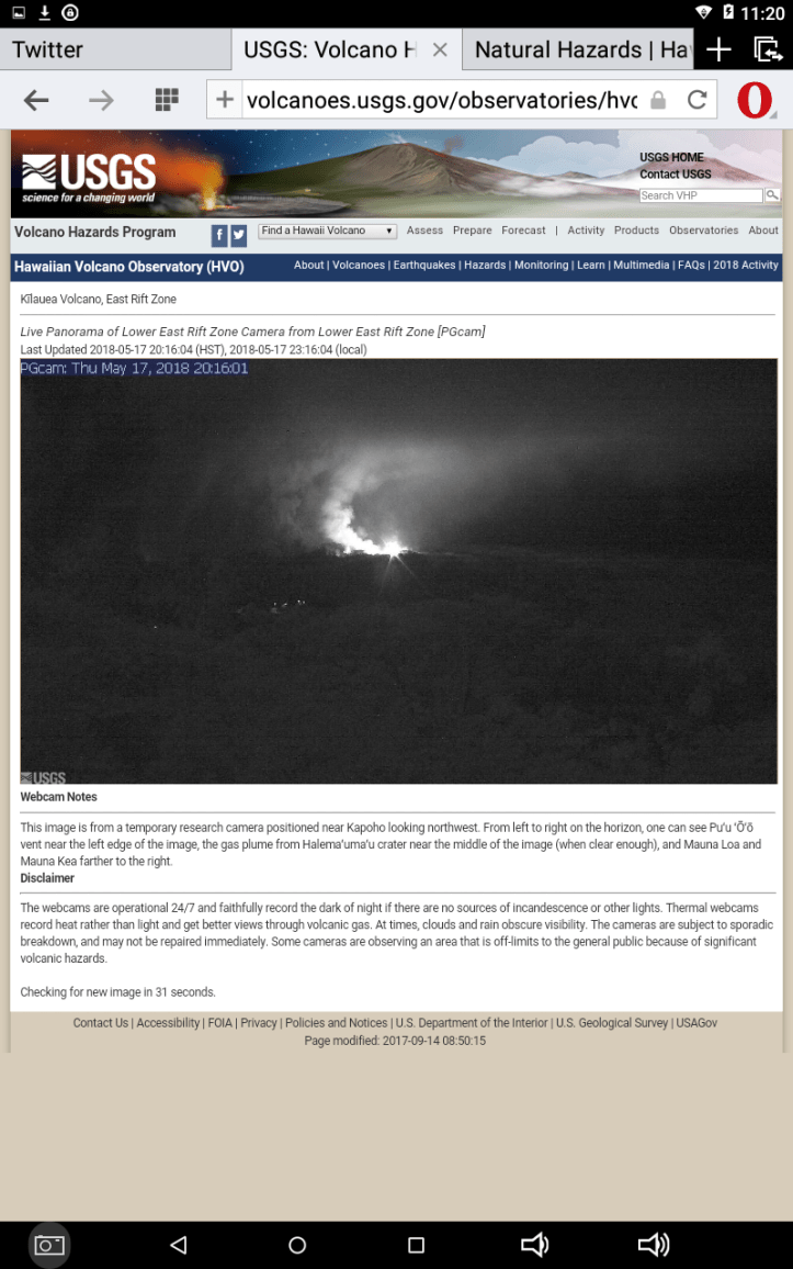
This morning that has died down.
I just wanted to get this concern up, and will check for other news. No HVO updates over the last eight hours or so. Will look around some more and add them below if I find any. Otherwise, will just keep watching and waiting.
1639 UTC: I don’t know where this camera is, but the lava is pahoepahoe, not the clinky a’a kind any more, and it moves quicker. This used to be fun to watch, but now it’s going through neighborhoods. 😦 (h/t Jascha Polet)
“https://youtu.be/cAZKIDok3 [Can’t get this to work — Barb]
If this is “new normal” for the fissure eruption — meaning the hotter, fresher lava has arrived in the zone — then it’s good to know that they streamlined the Local military command earlier in the week (May 16). Brigadier General Kenneth Hara can now command active-duty forces as well as the state Guard (which has been conducting mass-evacuation exercises since the fissure eruption began, just in case).
May 18, 2018, 1744 UTC: No update from HVO yet:
CD Fri 5/18 6AM. HVO reports new fissure 22. Several fissures active. Ash mask distribution 1 to 7pm@ Cooper Center & Ocean View CC.
— COH Civil Defense (@CivilDefenseHI) May 18, 2018
https://platform.twitter.com/widgets.js
Jim Kauahikaua, USGS geophysicist, said the amount of gas spewing from outbreaks in Leilani Estates and nearby Lanipuna Gardens is about the same as the amount that comes out of Halemaumau Crater. The difference? The crater isn’t in the middle of residential communities.
“The thing to remember is this is putting out as much sulfur dioxide as Halemaumau does normally,” he said.
— from KHNL news story
May 18, 2018, 2037 UTC: Today’s HVO update. Per the VNS that came out two hours after this was done, summit seismicity levels are increasing again. Things change quickly on an active volcano:
May 18, 2018, 2217 UTC: Posted about half an hour ago:
He writes at the video link:
WOW!!! Huge eruptions are happening at fissures below Leilani Estates! Two gigantic pahoehoe outbreaks are emanating from Fissures 16 and 17, and a towering high fountain eruption is blasting skyward at Fissure 17. The lava is spreading in various directions, but hasn’t gone too far yet. Highway 132 is still safe, at least for the time being. Much of the lava generated is pooling on top of the previous flows or moving to the south-southeast, but not from the distal tip of the flow front. Another sizable outbreak and small fountain is effusing hot rock from Fissure 18 in Lani Puna Gardens. The outbreak on Hookupu at the bottom of Leilani Estates is still active, spitting a bit, but has largely subsided. Nothing appears active above Hookupu. This is most likely lava from the collapsed Pu’u ‘O’o vent… it is much hotter and more fluid… scientists now expect to see more fountaining and longer flows from this eruption. The trade winds are back, so the SO2 is once again being blown to the south, and most of the subdivision has breathable air. Mahalo to pilot Colin Burkardt the kind folks at Paradise Helicopters… they offer the finest charters in the islands! Bruce Omori, Leilani and I had a fabulous lava overflight!
Per KHNL, 40 structures lost to this fissure eruption already (not all of them homes), 325 acres of land covered, and lots of damage to crops and vegetation in the Puna District. And:
Talmadge Magno, Hawaii County Civil Defense administrator, said Thursday that about 20 homes remain occupied in Leilani Estates…
,,,
Meanwhile, authorities continue to urge thousands living elsewhere in Kilauea’s east rift zone to be prepared to evacuate quickly.
Also there is this:
Department of Water Supply says emergency restriction in effect between Kapoho and Pohoiki. Please cease all irrigation in that area. Water spigots near entrance of Lava Tree State Park and a water tanker in Vacationland for public drinking water. #WaterRestriction #WaterSupply
— Mayor Harry Kim (@MayorHarryKim) May 18, 2018
https://platform.twitter.com/widgets.js
As beautiful as it was, I couldn’t watch Civil Beat’s video (below) of lava flowing from fissure #17 this morning. While live-blogging this eruption, I have discovered that Hawaiians are small-town Americans just like me–more than I realized–and I really feel for what they are going through here.
Stay safe, everybody.
Also, as noted below somewhere, I know that this is a walk-through for something my community here in the Pacific Northwest may experience someday. I think about that today again, as Mount St. Helens erupted on this date back in 1980.
May 19, 2018, 0019 UTC: Increasing SO2, per Hawaii County CD.
Eruption Update for May 18 at 1230. Several fissures producing lava spatter, lava flow located in Leilani and Lanipuna area. 40 structures destroyed; SO2 emissions elevated downwind of the vents. #mayorharrykimhttps://t.co/RucNP4pIdt
— Mayor Harry Kim (@MayorHarryKim) May 18, 2018
https://platform.twitter.com/widgets.js
There is a price to be paid for a glimpse of Nature’s awful beauty:
Spattering at Fissure 17, in Kīlauea Volcano’s Lower East Rift Zone, around 12:30 AM HST, May 18, 2018. The audio is the sound generated by the jetting of magma and gases from the fissure. https://t.co/WQjOjAgAYo pic.twitter.com/4VqiT6a56O
— USGS Volcanoes🌋 (@USGSVolcanoes) May 19, 2018
https://platform.twitter.com/widgets.js
KHNL: Fountaining up to 200 feet in the air, bombs, and explosions this afternoon. Volcanologists have confirmed that this lava was once in the summit lava lake.
The Civil Beat video is live again and USGS is sharing it, hoping to keep people safer. This is not something you want to get very close to because of the gas as well as the lava.
May 19, 2018, 0055 UTC: Around here, they just work on potholes! 🙂
#Kilauea #hitraffic update: On Highway 11 (Hawaii Belt Road), we have milled down the small height difference caused by the cracking after the seismic activity on May 16 and have a camera to monitor the highway near the entrance to Volcanoes National Park.
— Hawaii DOT (@DOTHawaii) May 19, 2018
https://platform.twitter.com/widgets.js
May 19, 2018, 0419 UTC:
#BREAKING #LeilaniEstatesEruption: Fast moving lava has crossed Pohoʻiki Rd near Malama Ki Pl. Residents in area being told to shelter in place as @CivilDefenseHI & Natl Guard prepare for helicopter evacuations https://t.co/Qy1pMbhLK0 @HawaiiNewsNow #HINews pic.twitter.com/AUN0er8eEs
— Mileka Lincoln (@MilekaLincoln) May 19, 2018
https://platform.twitter.com/widgets.js
And this–fissure 17’s lava (the big fountaining eruption) is something different from what they have ever seen at Kinauea, per KHNL.
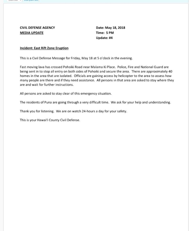
From earlier in the afternoon:
HAWAIIAN VOLCANO OBSERVATORY STATUS REPORT
U.S. Geological Survey
Friday, May 18, 2018, 3:59 PM HST (Saturday, May 19, 2018, 01:59 UTC)KILAUEA VOLCANO (VNUM #332010)
19°25’16” N 155°17’13” W, Summit Elevation 4091 ft (1247 m)
Current Volcano Alert Level: WARNING
Current Aviation Color Code: RED,Kīlauea Volcano Summit
No explosions and no earthquakes greater than magnitude 3.5 have occurred in the summit area in the past day. Background seismic levels have been increasing slowly over the course of the day.
Volcanic gas emissions at the summit remain high.
Kīlauea Lower East Rift Zone
The lower (eastern) end of the fissure system is the most active area today. This afternoon, fissure17 is actively spattering and the flow is active but is not covering new ground. In addition, fissures 18, and 20 are active, and the flow from fissure 18 has traveled approximately 0.6 miles in a southeast direction. An area 50-100 yards wide, parallel to and north of the line of fissures between Highway 130 and Lanipuna Gardens, is disrupted with many cracks. This long cracked area is currently being filled by pahoehoe lava flows from fissures 20 and 21. Fissure 15 was active and produced a lava flow that crossed Pohoiki Road between Leilani and Hinalo Streets.
Volcanic gas emissions remain elevated throughout the area downwind of the fissures.
Magma continues to be supplied to the lower East Rift Zone as indicated by the continued northwest displacement of a GPS monitoring station. Elevated earthquake activity continues, but earthquake locations have not moved farther downrift in the past couple of days.
USGS/HVO continues to monitor the lower East Rift Zone activity 24/7 in coordination with Hawaii County Civil Defense, with geologists onsite to track ongoing and new fissure activity and the advance of lava flows.
MORE INFORMATION
Activity Summary also available by phone: (808) 967-8862
Subscribe to these messages: https://volcanoes.usgs.gov/vns2/
Webcam images: https://volcanoes.usgs.gov/volcanoes/kilauea/multimedia_webcams.html
Photos/Video: https://volcanoes.usgs.gov/volcanoes/kilauea/multimedia_chronology.html
Lava Flow Maps: https://volcanoes.usgs.gov/volcanoes/kilauea/multimedia_maps.html
Definitions of terms used in update: https://volcanoes.usgs.gov/volcanoes/kilauea/extra/definitions.pdf
Overview of Kīlauea summit (Halemaʻumaʻu) and East Rift Zone (Puʻu ʻŌʻō ) eruptions:
https://volcanoes.usgs.gov/volcanoes/kilauea/extra/background.pdfSummary of volcanic hazards from Kīlauea eruptions:
https://volcanoes.usgs.gov/volcanoes/kilauea/extra/hazards.pdfRecent Earthquakes in Hawai’i (map and list):
https://volcanoes.usgs.gov/hvo/earthquakes/Explanation of Volcano Alert Levels and Aviation Color Codes:
https://volcanoes.usgs.gov/activity/alertsystem/index.php
https://pubs.usgs.gov/fs/2006/3139/CONTACT INFORMATION:
askHVO@usgs.gov
The Hawaiian Volcano Observatory is one of five volcano observatories within the U.S. Geological Survey and is responsible for monitoring volcanoes and earthquakes in Hawai`i.
You have received this email because you have subscribed to the USGS VNS.
To change your parameters, or unsubscribe from the service, go to https://volcanoes.usgs.gov/vns/
Two May 18 maps from the USGS map page.
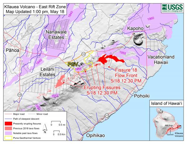
May 19, 2018, 0528 UTC: Per the May 18 press conference call, available here, HVO will be holding a press conference some time on the afternoon of the 19th. They do expect more explosions at the summit, and the NWS representative says trade winds will be breezy through this weekend, though they may weaken a bit next week.
The identification of the lava as coming from the summit and Pu’u O’o is from one sample only, from fissure 21.
At least on the webcam right now, there is no sign of that lava flow from the left side of the picture that appeared to be heading in the direction of what I assume is the geothermal plant.
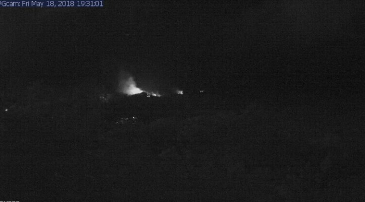
May 19, 2018, 0603 UTC: At least four people airlifted out of harm’s way after lava cut off 40 houses, per KHNL.
Per Hawaii County, there are still people there:
East Rift Zone Eruption – Update 5, 5/18/18 7:30PM – Pohoiki Road Closed.
This is a Civil Defense Message for Friday, May 18 at 7:30 in the evening.
Fast moving lava from Fissure 20 has crossed Pohoiki Road near Malama Ki Place, isolating approximately 40 homes in the area. All persons are asked to avoid the area.
Due to the volcanic activity, the following policies are in effect:
- Pohoiki Road is closed.
- Four (4) people were safely evacuated by County and National Guard helicopters.
- People still in that area are asked to stay in a safe place and wait for further instructions.
- Residents from Isaac Hale Beach Park to Kalapana are advised to prepare for voluntary evacuation should Highway 137 become threatened.
- For those evacuating, the Pahoa Community Center, Keaau Community Center, and Sure Foundation Church are open. Food will be provided and the shelters are pet friendly.
- Highway 137 and 130 are open.
The residents of Puna are going through a very difficult time. We ask for your help and understanding.
We are on watch 24-hours a day for your safety.
This is your Hawai‘i County Civil Defense
USGS just tweeted:
HVO status update 7:53 PM HST May 18, 2018: fast-moving lava flow from fissure 20 advancing at 300-400 yards per hour; poor air quality from elevated gas emissions and smoke from burning vegetation contributing to poor air quality in lower Puna.https://t.co/7sDZqcOJ5s
— USGS Volcanoes🌋 (@USGSVolcanoes) May 19, 2018
https://platform.twitter.com/widgets.js
May 19, 2018, 1541: A small steam explosion from Halema’uma’u Crater up at the summit around 1025 UTC, with some ash emission up to 10,000 feet, per Washington VAAC. Per HVO, the fast-moving flow from fissure 20 that began yesterday has three lobes:
The easternmost is east of Pohoiki Road and is moving about 230 yards per hour. The westernmost of the lobes is near Malamaki Road and is moving at about 40 yards per hour. These rates may change with time and USGS crews are in the area to monitor flow advance. Other fissures remain weakly active and volcanic gas emissions remain elevated throughout the area downwind. Smoke from burning vegetation as lava flows advance is also contributing to poor air quality.
For recent maps of activity, see: https://volcanoes.usgs.gov/volcanoes/kilauea/multimedia_maps.html
Additional ground cracking and outbreaks of lava are possible in the area. Residents downslope of the region of fissures should heed all Count of Hawaii Civil Defense messages and warnings.
Magma continues to be supplied to the lower East Rift Zone as indicated by the continued northwest displacement of a GPS monitoring station. Elevated earthquake activity continues, but earthquake locations have not moved farther downrift in the past couple of days
Apparently it was just those four people who needed rescuing last night, per KHNL. Highways 130 and 137 remain open just now, but they may close.
May 19, 2018, 1631 UTC: Nice post discussing eruptive history of Kilauea and the Puna District here :
Puna is not just a distant appendix of Kilauea. Pele loves it out here, and many of Kilauea’s eruptions push into this region. The volume may be limited, but Puna is one of the most volcanically active areas in the world and possibly the most active in Hawaii. The past 200 years were exceptional. The current eruption is business as usual. These lush gardens are built on a regular supply of molten rock. There is always a cost to paradise.
(h/t to Jascha Polet)
May 19, 2018, 1741: Per Hawaii County CD, four more homes destroyed, bringing the total up to 44 structures. No highways threatened at present.
May 19, 2018, 2154 UTC: It’s ramping up. Per the 1916 VNS,
Kīlauea Volcano Lower East Rift Zone
Eruption of lava and ground cracking in the area of Leilani Estates subdivision continues.
Beginning yesterday and continuing overnight, the rate of lava eruption has increased. Fountaining is occurring at Fissure 17, and Fissures 16-20 have merged into a continuous line of spatter and fountaining. Flows from the consolidated Fissure 20 crossed upper Pohoiki road late yesterday afternoon and continued flowing southward. This morning, the wide flow is very active and is advancing at rates up to 300 yds per hour. A second flow from the same fissure complex is also flowing southward between Pohoiki and Opihikao Rds. The lava flow from Fissure 18 continues to advance more slowly. Fissure 17 and its flow are still active but the flow is advancing even more slowly. It is unknown whether the flows will continue to advance, or stop, and new lava flows are likely given the rate of activity seen at the rift zone.
For recent maps of activity, see: https://volcanoes.usgs.gov/volcanoes/kilauea/multimedia_maps.html
Additional ground cracking and outbreaks of lava are possible in the area. Residents downslope of the region of fissures should heed all Count of Hawaii Civil Defense messages and warnings.
Magma continues to be supplied to the lower East Rift Zone; however, the GPS instrument near Pu`u Honua`ula is no longer moving suggesting that the rift zone is no longer inflating in this area. Elevated earthquake activity continues, but earthquake locations have not moved farther downrift in the past couple of days.
No word about seismicity at summit yet; haven’t heard their 11 a.m. call that was scheduled for this morning. There is supposed to be a press conference some time this afternoon, too.
Forgot to mention that there was a small explosion or two overnight at the summit. This was the seismic effect:
Updated event pages for Kilauea's summit explosions which registered as equivalent to a M 5.0 earthquake. 2018-05-19 09:58:33 UTC: https://t.co/OWl5XENA7d
2018-05-17 14:04:10 UTC: https://t.co/qxbtXoDYOh
2018-05-17 04:15:30 UTC: https://t.co/7kNChacWtn pic.twitter.com/YRY7sJMC0b— USGS_Seismic (@usgs_seismic) May 19, 2018
https://platform.twitter.com/widgets.js
Helicopter overflight of a fast-moving lava flow emerging from fissure 20, Kīlauea Volcano’s Lower East Rift Zone, May 19, 2018, at 7:52 AM HST. https://t.co/UcyANZarC6 pic.twitter.com/k5AMD7z2jX
— USGS Volcanoes🌋 (@USGSVolcanoes) May 19, 2018
https://platform.twitter.com/widgets.js
Also,
#LeilaniEstatesEruption #KilaueaVolcano LATEST: We’re #LIVE from the lower East Rift Zone at 12p, but here’s a USGS update: Fountaining is occurring at Fissure 17, and Fissures 16-20 have merged into a continuous line https://t.co/9RTtuHGhsG (Video: Ikaika Marzo) @HawaiiNewsNow pic.twitter.com/vRXhizVFEO
— Mileka Lincoln (@MilekaLincoln) May 19, 2018
https://platform.twitter.com/widgets.js
But the human spirit is there, too!
Our plans to provide electricity to Lower Puna may include traditional generators, portable solar-battery-generator packages and even temporary steel poles that can span lava fields and connect to undamaged distribution lines. #PlanningAhead
— HawaiiElectricLight (@HIElectricLight) May 19, 2018
https://platform.twitter.com/widgets.js
Apparently there was an ash emission from the summit at 1830 UTC per <a href="http://
Our plans to provide electricity to Lower Puna may include traditional generators, portable solar-battery-generator packages and even temporary steel poles that can span lava fields and connect to undamaged distribution lines. #PlanningAhead
— HawaiiElectricLight (@HIElectricLight) May 19, 2018
https://platform.twitter.com/widgets.js” rel=”noopener” target=”_blank”>VAAC. Light ashfall advisory in effect until 0300 UTC.
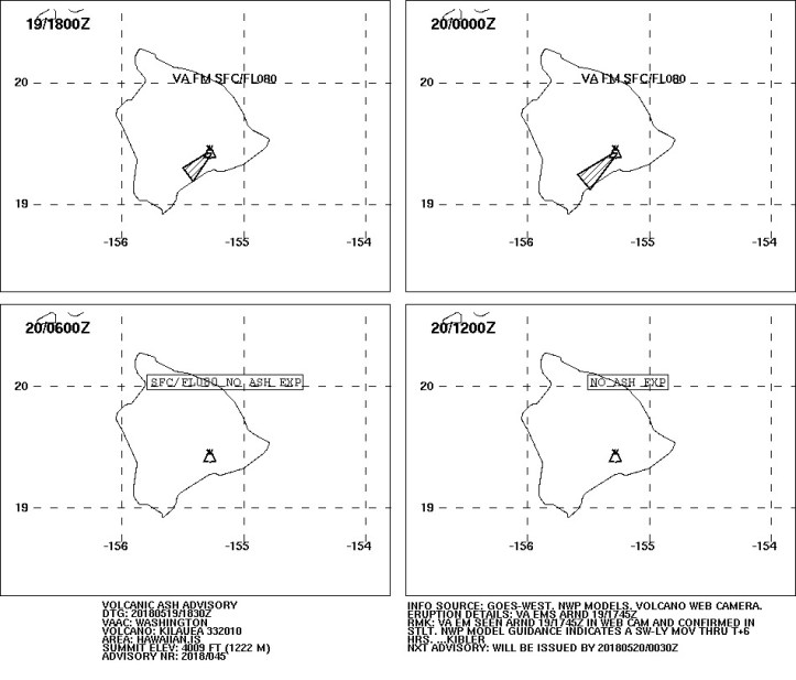
It’s a good thing the trades are strong today; there’s a lot of vog with all this activity currently at the webcam even with a stiff breeze!
Yesterday the NWS rep said that trade winds will be strong through the weekend but might weaken some next week.
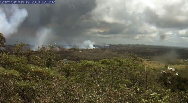
According to experts at USGS and UH Manoa, they are telling us we are seeing about 5.25 times as much SO2 being released now than before the recent active eruptions and new fissures started. Thus why there's a lot more vog now. #vog #hiwx #hivolcano
— Robert Ballard (@firebomb56) May 19, 2018
https://platform.twitter.com/widgets.js
I really hope those winds keep blowing, if this level of activity stays high or intensifies.
May 19, 2018, 2239 UTC:
#Kilauea #spatialreasoning #gis The Hawaii Civil Defense page with updated lava flow maps is excellent example of how rapid spatial analysis can keep people informed during a crisis (you can measure distances between vents etc) (https://t.co/LzCIHb9byo) pic.twitter.com/o9HNG8Yo1n
— Ben Edwards (@lava_ice) May 19, 2018
https://platform.twitter.com/widgets.js
May 19, 2018, 2301 UTC: I wish they didn’t use Facebook. I don’t like that platform. But here it is, if you want to watch. Will see if Naleo TV has it. (Update: They don’t, yet. Not livestreamed on YouTube, either.)
Join us on Facebook in a few minutes at 1pm HST for a live video media briefing by the park, USGS, NASA, and partners about the Kilauea Volcano.
— Hawaii Volcanoes NPS (@Volcanoes_NPS) May 19, 2018
https://platform.twitter.com/widgets.js
Meanwhile, it’s important to remember that the Big Island is, well, BIG. And the state includes many other islands, too.
REVISED: Pahoa is open for business. We ask that visitors and residents to stay out of the affected areas in Lower Puna, where the eruption is ongoing. Pahoa and Hilo are open for business, as is the entire rest of the Big Island #HIGov #HINews #kilaueaeruption pic.twitter.com/yliH5xw2lJ
— Governor David Ige (@GovHawaii) May 19, 2018
https://platform.twitter.com/widgets.js
May 20, 2018, 0006 UTC: Overflight from the 19th:
At least it’s flowing away from the geothermal plant. An awe-inspiring sight, but not through people’s yards and homes and lives . . .
May 20, 2018, 0158 UTC: Here is the USGS announcement regarding fissures. It doesn’t seem to be embedding well.
Now, in the last 30 minutes or so, there are tweets from Hawaii DOT saying that the lava flow may cut off Highway 137 in 4-7 hours (if and when it does, it will be right close to the sea). Also see the 2 p.m. HST CD alert.
Highway 130 runs right over the fissure line, and it was closed, but they struggled a few days ago to open it for very necessary local traffic, using steel plates to cover the cracks. H-DOT says they are checking the temperature of those steel plates now and working with the NPS and other agencies on an emergency access route via Chain of Craters Road.
Just to get oriented, I made a map based on the USGS current lava flow map and a Google Map for directions between Chain of Craters Road and Highway 137. It is not to scale, obviously. Look for the town of Pahoa on both maps. Highway 130 is to the left of Leilani Estates on the USGS map (left image). Highway 137 is down by the shore.
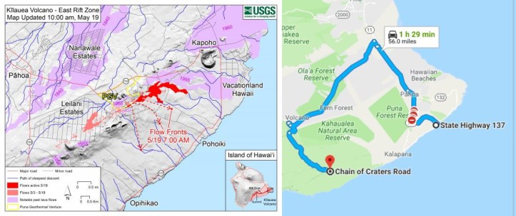
Of course there is much more on the ground than these main routes. All we need to know is that they are working on ways to keep local people safe.
And if you are an American (it probably works in similar ways elsewhere), you might not pay attention to the local decision makers who see to it that the roads are paved and other seemingly minor but very necessary details of our daily lives continue to function smoothly. We elect them every few years and most of us don’t even know who they are, fascinated as we are with the major media and electronic culture.
But such people are on the line now in lower Puna (and at higher levels in Hawaii’s government and emergency services hierarchy). And they’re doing a great job, even though it’s nowhere near as fascinating to watch as 200-meter-high lava fountains.
Exhibit A, wherever this fits into the emergency transport system–somebody made a decision and they paved the road beautifully in three days…finishing up exactly when it might be needed.
I am really proud of how all of my fellow Americans out there are handling themselves and hope to help them any way I possibly can.
PS: A little later, more background. Per KHNL:
Highway 137 is one of only two ways out of the area for residents in Lower Puna, the other route — Highway 130 — is currently only open to residents.
The Highway closure would impact thousands of residents trying to get in or out of the lava-affected areas. Residents between Kamaili and Pohoiki are being advised to decide if they want to voluntarily leave the area, although they are not in immediate danger at this time
And Hawai’i Electric Light has plans to maintain power to anyone cut off by the lava flows.
May 20, 2018, 0238 UTC: I don’t see VAAC or NWS advisories yet (later: here’s the VAAC advisory and a NWS special weather statement), but the current webcam view shows some residual.
New summit eruption from #Kilauea.#KilaueaVolcano #KilaueaErupts #KilaueaEruption pic.twitter.com/vdBZ9gL646
— x-CJ Moose #GoAvsGo ⚒🏒 (@cjmoose) May 20, 2018
https://platform.twitter.com/widgets.js
Meanwhile, closer to the sea:
Eruption Update for May 19 at 1400. Active lava flows in State Forest Reserve lands, heading in the general direction of MacKenzie State Park. Should the lava enter the ocean, be aware of the laze hazard and stay away from any ocean plume.https://t.co/6eRUmAGkPA
— Mayor Harry Kim (@MayorHarryKim) May 20, 2018
https://platform.twitter.com/widgets.js
“Laze” is a portmanteau word for “lava haze” and it includes nasty things like hydrochloric acid and tiny splinters of glass.
May 20, 2018, 0450 UTC: The lava is about a half-mile from Highway 137 and the sea. There may be some spectacular night-time lava entry video by morning HST.
The first injury has been reported, someone who got hit with a little bit of flying lava. Per KHNL, he went to the hospital but refused treatment. Per a later report, he was seriously injured.
Per the Honolulu Star-Advertiser, it has traveled a mile at least today. They also summarized the press conference and gave more information about Chain of Craters Road. At the time of writing this, there is also a lava-started brush fire in the area forcing some evacuations.
May 20, 2018, 0515 UTC: Peace amid all this volcanic turmoil: Halema’uma’u and the Belt of Venus on the webcam just now.
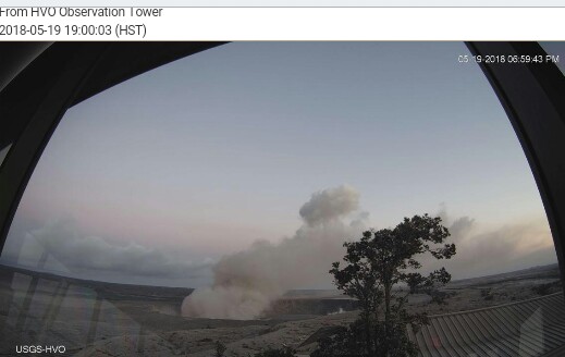
May 20, 2018, 1628 UTC:
Updated thermal map shows just how much area is being covered by these new flows: white, hot, flows are basically from yesterday, compared to older, grey, flows. Since this image was taken, less than 24 hrs ago, lava has reached ocean. https://t.co/FgFhli9aD7 pic.twitter.com/HY6bMUgwVd
— Jascha Polet (@CPPGeophysics) May 20, 2018
https://platform.twitter.com/widgets.js
The first lobe crossed Highway 137 and entered the ocean around 10:30 p.m. local time, per KHNL.
Per Hawaii County CD:
East Rift Zone Eruption – Update 8, 5/19/18 11PM
This is a Civil Defense Message for Saturday, May 19 at 11:00 in the evening.
Hawaiian Volcano Observatory continues to monitor active flows. Flow front #1 has crossed Highway 137 at the 13-mile marker and has entered the ocean. Flow front #2 is approximately 400 M from Highway 137. Highway 137 is closed between Kamaili Road and Pohoiki Road. Kamaili Road is closed between Highway 130 and Highway 137. All persons are asked to stay out of the area.
The lava has entered the ocean. Be aware of the laze hazard and stay away from any ocean plume.
- Laze is formed when hot lava hits the ocean sending hydrochloric acid and steam with fine glass particles into the air.
- Health hazards of laze include lung, eye and skin irritation.
- Be aware that the laze plume travels with the wind and can change direction without warning.
The residents of Puna are going through a very difficult time. We ask for your help and understanding.
We are on watch 24-hours a day for your safety.
This is your Hawai‘i County Civil Defense
Some video from yesterday’s press conference is online – this describes the Chain of Craters Road-Kalapana Road emergency road they are working on and includes a much better map than what I tried to do yesterday. They have to remove a lot of hardened igneous rock first.
There are no new online updates from the geologists yet. However, here are two of them, doing their thing. Without humans for scale, it’s difficult to realize just how much lava is flowing through Lower Puna right now!
Just for a little bit of scale and a reality check… The two circled white specks are @USGSVolcanoes workers going down to collect lava samples earlier today. #hawaiivolcanohttps://t.co/EAYpbsA30w pic.twitter.com/i1b9Yr3wSk
— Kimberly (@kimberlyaliceMT) May 20, 2018
https://platform.twitter.com/widgets.js
Meanwhile, research on this eruption is helping volcanologists tremendously, including giving them lots of data that may eventually allow better predictions of steam explosions–what’s going on at Kilauea’s summit currently–like the lethal one on Ontake back in 2014.
Webcam views show a lot of what appears to be fog in the fissure area; I wonder if it’s steam from the coastal entry point. Time will tell – fog would burn off during the day.
The National Weather Service still has a special weather statement up about trace ashfall from Kilauea’s summit, but the plume there appears typical right now.
May 20, 2018, 1648 UTC: Washington VAAC reports ash emission from Kilauea. Here’s the graphic.
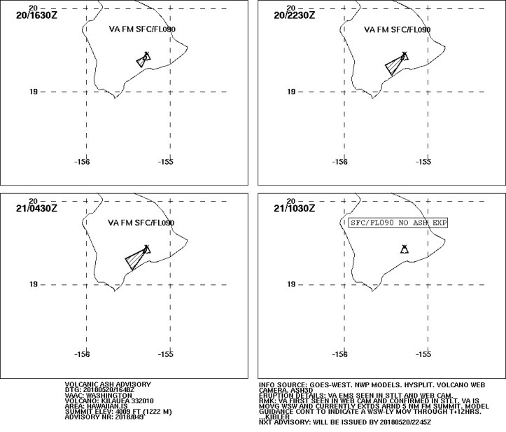
Summit is back to normal on webcam. (See note below re: information scientists are gathering about steam explosions like this.)
Additional note: NWS has a new special weather statement.
Meanwhile, Hawaii County CD says that two flows are entering the ocean now and SO2 levels are elevated. From modeling, I wonder if ash and gas are affecting efforts to clear and use Chain of Craters Road.
East Rift Zone Eruption – Update 1, 5/20/18 6AM – Flow 3 Split Into 2 Flows, Entering Ocean
This is a Civil Defense Message for Sunday, May 20 at 6:00 in the morning.
Hawaiian Volcano Observatory continues to monitor active flows. Flow front 3 has split into 2 flows and both are entering the ocean. Hawaiian Volcano Observatory also reports that Sulfur Dioxide emissions have greatly increased.
Due to hazardous conditions, the following roads are closed and all are asked to stay out of the area
- Highway 137 is closed between Kamaili Road and Pohoiki Road.
- Kamaili Road is closed to all through traffic.
Due to the lava entering the ocean off Highway 137 in the vicinity of McKenzie Park, the following policies are in effect:
Be aware of the laze hazard and stay away from any ocean plume. Laze is formed when hot lava hits the ocean sending hydrochloric acid and steam with fine glass particles into the air.
- Health hazards of laze include lung damage, and eye and skin irritation.
- Be aware that the laze plume travels with the wind and can change direction without warning.
The residents of lower Puna are going through a very difficult time. We ask for your help by avoiding the affected areas if possible. Thank you for your understanding.
We are on watch 24-hours a day for your safety.
By the way, I’m keeping an eye out for news of the well-killing efforts at Puna Geothermal, but have seen nothing lately. No news is good news, hopefully.
And from space, earlier in this new eruptive phase yesterday (h/t Jeannie Curtis tweet))
#volcan #volcano #Kilauea Les 20 évents de la fissure éruptive ouverte dans Leilani Estates et Lanipuna Gardens vue hier depuis l'espace/The 20 fissure vents opened in #LeilaniEstates and #LanipunaGardens seen yesterday from space; Image/pict @CopernicusEU @esa pic.twitter.com/iWywwScRHc
— CultureVolcan (@CultureVolcan) May 19, 2018
https://platform.twitter.com/widgets.js
May 20, 2018, 1805 UTC: Good morning, new land!
#LeilaniEstatesEruption #KilaueaVolcano #HAPPENINGNOW: An incredible new image of the sun rising over Puna as pāhoehoe lava enters the ocean off of Mālama Flats after crossing Hwy137 Saturday night https://t.co/5VbbwlSLxd @HawaiiNewsNow #HINews #HawaiiNews (Photo: Dave Okita) pic.twitter.com/6PrlnbEaou
— Mileka Lincoln (@MilekaLincoln) May 20, 2018
https://platform.twitter.com/widgets.js
Per a 1700 UTC update at the Star-Advertiser:
A separate flow moving in a more southerly direction created the brush fires threatening Kamaili.
No word on the current status of those fires yet in the sources I check frequently, so presumably they’re still going on.
I am ending this live-blog of the Kilauea eruption now, though of course it goes on for those involved, and the volcano itself has been active since the 1980s. A phase in this ongoing story of how the planet evolves, and how we respond to it, is now complete.
For more information, here are some sources that have been useful to me:
- Hawaii County Civil Defense alerts
- USGS Kilauea status page
- USGS summit panorama webcams
- USGS East Rift webcam
- Other USGS/HVO webcams
- USGS/HVO Volcano Watch
- USGS/HVO resources page for this eruption
- Na Leo TV Channel 55 and VOD
- NWS Honolulu Watches and Warnings page
- Washington VAAC
- Big Island Videos
- The Paradise Copters overflights guy, Mick Kalber
- All of the various tweeters represented below
- KHNL
- Honolulu Star-Advertiser ongoing coverage
And here is more information about the summit activity (from June 6th), as well as a livestream of Halemaumau Crater.
This collection of USGS videos and other media was posted on July 2, 2019. That’s within the time frame that I didn’t live-blog about this eruption, partly because it was getting plenty of media coverage at this point and partly because it was so sad to watch people struggling to deal with it and losing all they had.
And, as you probably recall, this happened:
August 3, 2018: So much has changed at Kilauea since that last post–for one thing, there is much more new land, located on a different part of the coast. This is just to point you to HVO’s latest published thoughts on when the eruption might end: not soon. Read the whole thing, but basically the monitoring right now shows magma being replaced just as quickly as it flows out of the ground. This is not really surprising, considering that both Pu’u O’o and the summit lava lake drained just before the LERZ activity began.
Sigh.
August 5, 2018: The last summit collapse was on August 2nd. Yesterday, around noon HST, the Halemaumau area was rocking, judging by the number of rockfalls you could see on the livestream. Later, HVO said it was having around 30 quakes an hour at that point. Now, apparently, the seismicity has quieted down (there were few to no rockfalls visible on the webcam livestream later in the day). And maybe the eruption may really be slowing down; time will tell. . .
#Kilauea #Volcano Update from last night. #LERZ #fissure8 output is down. Last #TypeA collapse 2 days ago & number of earthquakes decreased. #Eruptions wax and wane, but both these changes indicate magma leaving summit has decreased.
More info after this morning's overflight.
— USGS Volcanoes🌋 (@USGSVolcanoes) August 5, 2018
https://platform.twitter.com/widgets.js
August 6, 2018, 8:46 a.m.:
#KilaueaVolcano Summit. #ThenAndNow
Left: April 18, 2018 #Halemaumau Crater #lavalake.
Right: July28, 2018 deeper crater & summit coated in ash. #KilaueaEruption #KilaueaErupts
Seismicity & deformation at the summit remain low.
No #fissure8 lava visible flowing out of vent. pic.twitter.com/L9Sy3w7VnZ— USGS Volcanoes🌋 (@USGSVolcanoes) August 6, 2018
https://platform.twitter.com/widgets.js
August 6, 2018, 4 p.m. (Pacific): Since everybody is basically waiting for Kilauea’s next move, instead of trying to keep up with rapidly changing conditions at the volcano, there’s no need to post every one of these daily HVO updates. However, this one is of special interest as they go into some depth in discussion of the changes at the LERZ and the summit.
I haven’t been following the daily updates (got caught up in the human drama of May and June in the Puna District; also, while the lava flows are terribly beautiful, all the dead vegetation is depressing). I didn’t realize there have been some changes at Pu’u O’o, roughly midway between the summit and LERZ, too.
Most up-to-date links for more information are at the bottom of today’s update, copied and pasted below. Further HVO Kilauea updates are here.
HAWAIIAN VOLCANO OBSERVATORY STATUS REPORT
U.S. Geological Survey
Monday, August 6, 2018, 12:49 PM HST (Monday, August 6, 2018, 22:49 UTC)
KILAUEA VOLCANO (VNUM #332010)
19°25’16” N 155°17’13” W, Summit Elevation 4091 ft (1247 m)
Current Volcano Alert Level: WARNING
Current Aviation Color Code: ORANGE
Kīlauea Volcano Lower East Rift Zone
Activity and lava output from fissure 8 remains low. This morning’s overflight crew saw a weak to moderately active bubbling lava lake within the fissure 8 cone, a weak gas plume, and a completely crusted lava channel. Later in the morning, ground crews found the upper channel largely devoid of lava confirming that the channel is empty to at least the vicinity of Kapoho Crater where a short section of spiny active lava in a channel was present. There were small active ooze outs near the coast on the Kapoho Bay and Ahalanui lobes but the laze plume was greatly diminished. Active lava is close to the Pohoiki boat ramp but has not advanced significantly toward it.
The significance of this change is not yet clear and hazardous conditions remain in the area. HVO field crews and the UAS team will monitor activity throughout the day and overnight.
It is common for eruptions to wax and wane or pause completely. A return to high levels of lava discharge or new outbreaks in the area of active fissures could occur at any time.
Residents should remain informed and heed Hawaii County Civil Defense messages and warnings.
Kīlauea Volcano Middle East Rift Zone
On Friday, gas measurements of the Puʻu ʻŌʻō plume indicated an emission rate of over 1,000 tons/day of SO2, the highest rate from this vent in several years. Readers may recall that a white plume has been observed issuing from Puʻu ʻŌʻō over the past several weeks. From this morning’s overflight, observers confirmed that increased gas and steam are coming from the crater but that temperatures do not seem significantly higher than on previous visits. No active lava was observed.
Kīlauea Volcano Summit
The volcano’s summit remains quiet following the most recent collapse event four days ago (11:55 a.m. HST August 4). This continues a significant departure from the pattern of seismicity and deformation over the past several months, with very low rates of seismicity continuing today. The deformation at the summit as measured by tiltmeter and GPS instruments has virtually stopped.
Summit and LERZ changes considered together imply that the rate of magma leaving the summit to feed the Lower East Rift Zone eruption has decreased. How long this condition will persist is unknown. It is possible that outflow will pick up again, resulting in renewed summit area deflation leading to another collapse event and renewed eruption vigor on the LERZ.
HVO will continue to monitor Kīlauea closely for any signs of change in activity.
The next status report will be issued tomorrow morning unless significant changes occur.
MORE INFORMATION
Subscribe to these messages: https://volcanoes.usgs.gov/vns2/
Webcam images: https://volcanoes.usgs.gov/volcanoes/kilauea/multimedia_webcams.html
Photos/Video: https://volcanoes.usgs.gov/volcanoes/kilauea/multimedia_chronology.html
Lava Flow Maps: https://volcanoes.usgs.gov/volcanoes/kilauea/multimedia_maps.html
Definitions of terms used in update: https://volcanoes.usgs.gov/volcanoes/kilauea/extra/definitions.pdf
Overview of Kīlauea summit (Halemaʻumaʻu) and East Rift Zone (Puʻu ʻŌʻō ) eruptions:
https://volcanoes.usgs.gov/volcanoes/kilauea/extra/background.pdf
Summary of volcanic hazards from Kīlauea eruptions:
https://volcanoes.usgs.gov/volcanoes/kilauea/extra/hazards.pdf
Recent Earthquakes in Hawai’i (map and list):
https://volcanoes.usgs.gov/hvo/earthquakes/
Explanation of Volcano Alert Levels and Aviation Color Codes:
https://volcanoes.usgs.gov/activity/alertsystem/index.php
https://pubs.usgs.gov/fs/2006/3139/
CONTACT INFORMATION:
askHVO@usgs.gov
The Hawaiian Volcano Observatory is one of five volcano observatories within the U.S. Geological Survey and is responsible for monitoring volcanoes and earthquakes in Hawai`i.
August 6, 2018, 6:23 p.m. (Pacific):
Today's #HVO #Kīlauea Volcano update (12:49 PM HST) paints a picture of a pause – but we're not yet ready to say if it's a full stop. https://t.co/7sDZqcOJ5s #KilaueaErupts #LERZ #Halemaumau #LeilaniEstates #Kapoho pic.twitter.com/BeV89gPi3u
— USGS Volcanoes🌋 (@USGSVolcanoes) August 6, 2018
https://platform.twitter.com/widgets.js
August 17, 2018: From the USGS volcano alerts page:
HVO/USGS Volcanic Activity Notice
Volcano: Kilauea (VNUM #332010)
Current Volcano Alert Level: WATCH
Previous Volcano Alert Level: WARNING
Current Aviation Color Code: ORANGE
Issued: Friday, August 17, 2018, 8:39 AM HST
Source: Hawaiian Volcano Observatory
Notice Number:
Location: N 19 deg 25 min W 155 deg 17 min
Elevation: 4091 ft (1247 m)
Area: Hawaii
Volcanic Activity Summary: Lowering Alert Level from WARNING to WATCH
In light of the reduced eruptive activity at Kīlauea Volcano over the last several days, HVO is lowering the Alert Level for ground based hazards from WARNING to WATCH. This change indicates that the hazards posed by crater collapse events (at the Kīlauea summit) and lava flows (Lower East Rift Zone; LERZ) are diminished. However, the change does not mean with absolute certainty that the LERZ eruption or summit collapses are over. It remains possible that eruption and collapse activity could resume.
Although no signs of imminent hazardous activity are present at this time, residents of the region near recently active fissures should stay informed, heed Civil Defense warnings, and be prepared, if necessary, to self-evacuate.
The aviation color code remains at ORANGE.
For definitions of Alert Levels and Aviation Color Codes, see: https://volcanoes.usgs.gov/vhp/about_alerts.html
The Hawaiian Volcano Observatory (HVO) will continue to closely monitor Kīlauea’s seismicity, deformation, and gas emissions for any sign of reactivation, and maintain visual surveillance of the summit and LERZ. HVO will continue to issue daily updates and additional messages as needed.
Remarks: Background and Prognosis
Kīlauea Volcano has remained quiet for well over a week now, with no collapse events at the summit since August 2. Except for a small, crusted-over pond of lava deep inside the fissure 8 cone and a few scattered ocean entries, lava ceased flowing in the LERZ channel on August 6. Sulfur dioxide (SO2) emissions rates at the summit and LERZ are also drastically reduced (the combined rate is lower than at any time since late 2007).
It remains too soon to tell if this diminished activity represents a temporary lull or the end of the LERZ lava flows and/or summit collapses. In 1955, similar pauses of 5 and 16 days occurred during an 88-day-long LERZ eruption. During the Mauna Ulu eruption (1969-1974), a 3.5 month pause occurred in late 1971.
HVO will continue to record detailed visual observations and scrutinize incoming seismic, deformation, and gas data, looking for evidence of significant movement of magma or pressurization as would be expected if the system was building toward renewed activity.
Ongoing Hazards
Whether this is a pause or truly the end of the current eruption, certain hazardous conditions remain in the LERZ and at the summit as described below:
The new lava flow field in the LERZ includes large areas of still-hot, rugged, and unstable lava surfaces that are subject to collapse.
SO2 gas emissions have greatly decreased from LERZ vents, but high levels of SO2 may persist in downwind areas.
Around fissure 8, thick accumulations of tephra hide underground hazards such as holes and cracks; winds can pick up glassy fragments including Pele’s hair and carry them downwind.
At the LERZ ocean entry, laze and lava delta collapses remain a concern. Hydrovolcanic explosions may still occur during collapses of lava deltas in areas where the coastline has extended.
At the summit, rockfalls and ground cracking can still occur with no warning. Steep crater walls destabilized by months of earthquakes could be prone to collapse for weeks or months to come, even without further ground shaking.
Resuspended ash in the summit region and Pele’s hair in the LERZ remain a local hazard during strong winds.
As the summit continues to adjust to recent changes, additional, and potentially damaging, earthquakes are possible. Hawai’i is known for frequent earthquakes, so all residents should always be prepared for damaging earthquakes.
If the Kīlauea eruption in the LERZ does resume in the coming days, we expect, but cannot guarantee, that increases in seismicity, deformation, and/or gas emissions will provide advance warning. Activity could resume quickly and residents in the LERZ should be prepared to self-evacuate. Resupply of magma to the LERZ could lead to new areas being inundated by lava.
At Kīlauea’s summit, further draining of the magma reservoir could produce more collapse events. Alternatively, resupply of magma to the summit reservoir could lead to hydrovolcanic explosions, or, to the reappearance of lava in the caldera.
Contacts: askHVO@usgs.gov
Next Notice: Daily updates on all volcanic activity at Kīlauea are issued each morning and posted on out website: https://volcanoes.usgs.gov/volcanoes/kilauea/status.html
You can sign up to receive these messages automatically by visiting https://volcanoes.usgs.gov/vns2/
The Hawaiian Volcano Observatory is one of five volcano observatories within the U.S. Geological Survey and is responsible for monitoring volcanoes and earthquakes in Hawai`i.
August 21, 2018, 11:27 a.m Pacific: Uh-oh. This is the first decisive statement I’ve seen from USGS since things quieted down, even if it does contain the word “may”:
Yesterday's #Kilauea #Volcano #LERZ overflight revealed incandescent gas jets in #Fissure8 throwing spatter (light gray deposits). Activity indicates #eruption may be paused vs. pau. #KilaueaErupts #KilaueaEruption pic.twitter.com/NU36ly5hb9
— USGS Volcanoes🌋 (@USGSVolcanoes) August 21, 2018
https://platform.twitter.com/widgets.js
The Puna District and other stakeholders can’t relax just yet.
Of note, while retweeting this just now, I noticed that #LERZ is now a Twitter hashtag. Cool! One nice thing about volcanoes–and it’s good to point these out in the midst of the damage, destruction, and desolution of an eruption–is that they bring laypeople and scientists together in the common interest.
Another good thing about this particular eruption is that laypeople are getting to watch the unpredictability that’s part of the picture with any active or awakening volcano (not personal experience, as I’m not a geologist–just observations over a decade or more of Internet volcano geekery and the good fortune to have found reliable online sources as soon as I got interested).
Hawaiian volcanoes are good teachers because they’re pretty, everybody knows about them, and they aren’t as scary as the more explosive kind. I don’t want to see more lava in this eruption, but if it does resume, a lot of people will likely have an “ah-ha!” moment that will make them less likely to expect the impossible of volcanologists at a restless volcano (less of the “why can’t you tell me when this thing will go off”).
If you want to know more about science-laypeople communication and planning issues, check out this free ebook: Observing the Volcano World: Volcano Crisis Communication, written by experts but not highly technical. The ebook is open access from Springer.
August 25, 2018: In their daily update today, HVO reports a small lava pond at Fissure 8. Also, Hurricane Lane took out some of their equipment on the east side, but they can still monitor the volcano.
August 28, 2018: So much for the lava pond, at least at this moment.
No incandescent #lava in #Kilauea's #fissure8 cone. Only one small #oceanentry. Summit & #LERZ #seismicity & #deformation remain low; #SO2 levels lower than at any time since late 2007. #HVO lost communication with few instruments b/c of #HurricaneLane. https://t.co/7sDZqcOJ5s pic.twitter.com/elzXsD7Dq7
— USGS Volcanoes🌋 (@USGSVolcanoes) August 28, 2018
https://platform.twitter.com/widgets.js
Back to waiting…waiting…
August 30, 2018:
UAS overflight of fissure 8 shows no incandescence within the cinder cone. Minor amounts of gases, primarily steam, rise from the cone and areas along #Kilauea’s #LERZ. https://t.co/BXT8NXQk3T pic.twitter.com/UDaLgZbHit
— USGS Volcanoes🌋 (@USGSVolcanoes) August 29, 2018
https://platform.twitter.com/widgets.js
August 31, 2018: Per today’s HVO update:
The most recent deformation results in the LERZ do not show patterns that would be consistent with rift opening or closing. If the subsurface magma intrusion is cooling, those effects are not yet strong enough to be detectable.
At least it’s not opening, i.e., more magma pushing in.
Meanwhile, up at the summit earlier this week . . .
Fly the crater rim with the UAS team at #Kilauea Volcano's summit; crater floor has dropped 1600 ft since May; seismicity remains low and ground deformation negligible; pau or paused? https://t.co/QmWjtviFhc pic.twitter.com/4St9izAUfX
— USGS Volcanoes🌋 (@USGSVolcanoes) August 30, 2018
https://platform.twitter.com/widgets.js
September 2, 2018: From today’s update:
On the volcano’s lower East Rift Zone (LERZ), incandescence was observed in the fissure 8 cone yesterday afternoon (09/01) with reports of activity extending into early evening. In addition to a persistent spot of spattering, lava slowly covered the 65-by-15 m (210-by-45 ft) crater floor by evening. Webcam views showed weak incandescence occasionally reflected on the eastern spillway wall from the crater overnight suggesting that the lava in the crater remained active. This morning, ground crews have no view of the crater inside the fissure 8 cone, but report the fissure 8 cone is quiet when viewed from a safe distance with no visible fume. Sulfur dioxide emission rates at the summit, Puʻu ʻŌʻō, and LERZ are drastically reduced; the combined rate (< 1,000 t/d) is lower than at any time since late 2007. Friday (08/31), LERZ emission rates were still too low to measure
No relevant images up yet.
Update, a few hours later:
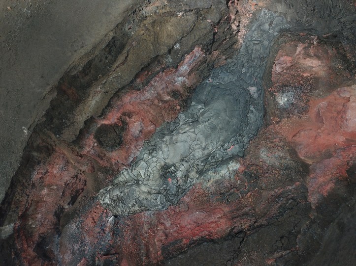
Per Hawaii County CD:
This is a Civil Defense Eruption Update for Sunday, September 2 at 9:30 in the morning.
The Hawaiian Volcano Observatory (HVO) reports that yesterday afternoon and early evening, spattering was observed in the fissure 8 cone. It is common for eruptions to go through periods of diminished output, or to pause completely, only to reactivate days, weeks, or even months later.
At this time, the following access policies and restrictions are in effect:
-Access to the entire lava flow field (i.e., the fissures, etc.) and a 50-yard perimeter are restricted. The flow field is extremely dangerous and remains off limits. Please be aware that the community needs to respect the private property rights of the residents in the lava zone, and trespassers will be prosecuted.
-Highway 132 checkpoint between Nanawale and Lava Tree State Park remains closed to the public, with access only to residents, officials, and authorized personnel with placards.
-Properties not destroyed, but isolated by lava on E. Pohoiki Road, Malama Ki Place, Halekamahina Road, and E. Pahoa-Kapoho Road are accessible to residents with Civil Defense authorization only.
-Leilani Estates access is limited to residents, officials, and authorized personnel with placards. Property on, and east of Pomaikai Street is in the mandatory evacuation area. For access to this area, residents must make an appointment with Civil Defense for an escort.
-Placards are available Monday through Friday at the Civil Defense office in Hilo, located at 920 Ululani Street from 8 AM to 4 PM.
We will continue to monitor this eruption activity and inform you of any changes that could affect your safety.
Thank you for your cooperation and patience. This is your Hawaii County Civil Defense Agency.
September 3, 2018: Per HVO photos page:
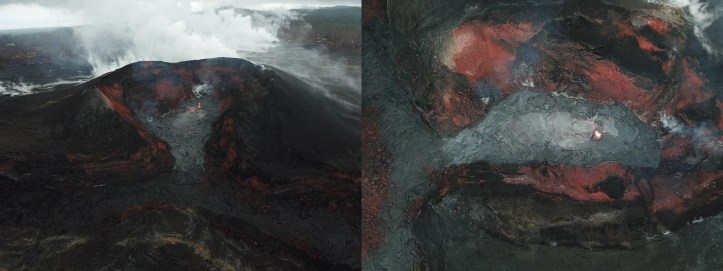
September 4, 2018: HVO says lava has filled the floor but is not moving into the spillway. Image from today’s overflight, with HVO text:
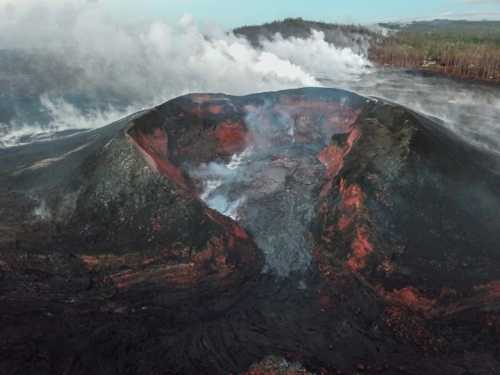
September 5, 2018: From today’s HVO update (emphasis added):
KILAUEA VOLCANO (VNUM #332010)
19°25’16” N 155°17’13” W, Summit Elevation 4091 ft (1247 m)
Current Volcano Alert Level: WATCH
Current Aviation Color Code: ORANGEKīlauea summit and lower East Rift Zone
Seismicity remains low and ground deformation is negligible at the summit of Kīlauea Volcano. A magnitude-3.1 earthquake that occurred at 5:31AM HST this morning was located below Kīlauea’s South Flank and is likely an aftershock of the magnitude-6.9 earthquake from early May.
On the volcano’s lower East Rift Zone (LERZ), no incandescence was visible on the fissure 8 spillway overnight. Images from the UAS (drone) crew showed that weak lava activity continues in the fissure 8 cone as of yesterday afternoon, with no lava extending outside the walls of the cone and no flows heading down the spillway.
Sulfur dioxide emission rates at the summit, Puʻu ʻŌʻō, and LERZ are drastically reduced; the combined rate (< 1,000 t/d) is lower than at any time since late 2007. SO2 emission rate measurements from LERZ vents were slightly higher than those measured in the past week but still low.
The Hawaiian Volcano Observatory (HVO) continues to closely monitor Kīlauea’s seismicity, deformation, and gas emissions for any sign of reactivation, and maintains visual surveillance of the summit and LERZ. HVO will continue to issue daily updates and additional messages as needed. The next update will be issued tomorrow morning unless significant changes occur.
Current webcam views are here: https://volcanoes.usgs.gov/volcanoes/kilauea/multimedia_webcams.html
So we’re still waiting…waiting…
September 6, 2018: From the HVO update today, with emphasis added. It’s a mixed bag, with a few more signs of possible refilling but with extremely low SO2 levels, which suggests to this rank amateur either very little lava or molten stuff with less gas in it than the batch that has already erupted. Volcanoes are fascinating–but this is all very hard on the people of the Puna District and the state, who have already been through so much with Kilauea this year and are still waiting…waiting…:
KILAUEA VOLCANO (VNUM #332010)
19°25’16” N 155°17’13” W, Summit Elevation 4091 ft (1247 m)
Current Volcano Alert Level: WATCH
Current Aviation Color Code: ORANGEKīlauea summit and lower East Rift Zone
On Kīlauea Volcano’s lower East Rift Zone (LERZ), a small amount of incandescence was visible from the fissure 8 cone for a brief period overnight. Small lava flows have been observed within the fissure 8 cone, however none extend outside the walls of the cone. There is no change in overall activity from observations over the past several days.
Seismicity and ground deformation remain low at the summit of Kīlauea Volcano. Earthquakes activity continues on faults located on Kīlauea’s South Flank; these are aftershocks of the magnitude-6.9 earthquake in early May.
Tiltmeters in Kīlauea’s middle East Rift Zone have recorded small amounts of inflationary tilt, which may be a sign of refilling of the rift zone. The current rates are much smaller than those measured during the period of major eruptive activity and are not changing rapidly.
Sulfur dioxide emission rates at the summit, Puʻu ʻŌʻō, and LERZ are drastically reduced; the combined rate (< 1,000 tonnes/day) is lower than at any time since late 2007. SO2 emission rate measurements from LERZ vents measured on September 5 were below 20 tonnes/day, close to the detection threshold of the measurement technique.
The Hawaiian Volcano Observatory (HVO) continues to closely monitor Kīlauea’s seismicity, deformation, and gas emissions for any sign of reactivation, and maintains visual surveillance of the summit and LERZ. HVO will continue to issue daily updates and additional messages as needed.
MORE INFORMATION
Subscribe to these messages: https://volcanoes.usgs.gov/vns2/
Webcam images: https://volcanoes.usgs.gov/volcanoes/kilauea/multimedia_webcams.html
September 7, 2018: Still waiting on today’s HVO update, but here are some images from yesterday.
First, there’s a little cone (volcanologists call these hornitos) from lava spattering inside Fissure 8:
Watch the little cone grow, in this short video from inside fissure 8, on #Kilauea Volcano's #LERZ. It's 10-13 ft high! https://t.co/qy2rtfKc5m pic.twitter.com/fJZ9ljgJwA
— USGS Volcanoes🌋 (@USGSVolcanoes) September 6, 2018
https://platform.twitter.com/widgets.js
Next, Paradise Copters took advantage of break in the weather yesterday to check out the LERZ, then P’u O’o (still an awesome hole in the ground!), and finally, the collapsed caldera at Kilauea’s summit:
September 10, 2018, 1:45 p.m. Pacific: At time of writing, no photos are up yet–Hawaii has been dealing with tropical cyclones a lot lately, and at present is in Olivia’s cross-hairs, so this is not surprising.
Note that the inflation is continuing, just not as quickly. Emissions are still very low, which is great!
HAWAIIAN VOLCANO OBSERVATORY DAILY UPDATE
U.S. Geological Survey
Monday, September 10, 2018, 9:27 AM HST (Monday, September 10, 2018, 19:27 UTC)KILAUEA VOLCANO (VNUM #332010)
19°25’16” N 155°17’13” W, Summit Elevation 4091 ft (1247 m)
Current Volcano Alert Level: WATCH
Current Aviation Color Code: ORANGEKīlauea summit and lower East Rift Zone
On Kīlauea Volcano’s lower East Rift Zone (LERZ), a small collapse pit formed within the fissure 8 cone over the past day, exposing hot material underneath and producing an increase in incandescence. No surface flow was associated with this event. Small lava flows have been observed within the fissure 8 cone, however none have extended outside the walls of the cone.
Seismicity and ground deformation remain low at the summit of Kīlauea. Aftershocks from the magnitude-6.9 earthquake in early May are still being generated on faults located on Kīlauea’s South Flank.
Small collapses continue to occur at Puʻu ʻŌʻō crater, producing visible brown plumes. The rate of inflationary tilt recorded by a nearby tiltmeter has slowly decreased over the past day and another tiltmeter in the East Rift Zone is also showing a slight decrease in inflationary tilt. However, there is no change in seismicity rate at this time. We will continue to watch these data for changes.
Sulfur dioxide (SO2) emission rates at the summit, Puʻu ʻŌʻō, and LERZ are drastically reduced; the combined rate is less than 1,000 tonnes/day, which is lower than at any time since late 2007. SO2 emission rates from LERZ vents were below 20 tonnes/day when measured on September 5th, close to the detection threshold of the measurement technique.
The Hawaiian Volcano Observatory (HVO) continues to closely monitor Kīlauea’s seismicity, deformation, and gas emissions for any sign of reactivation, and maintains visual surveillance of the summit and LERZ. HVO will continue to issue daily updates and additional messages as needed.
There wasn’t any change yesterday; not much today, either, except where I added emphasis below (also note useful links at the end of this update):
HAWAIIAN VOLCANO OBSERVATORY DAILY UPDATE
U.S. Geological Survey
Sunday, September 9, 2018, 9:40 AM HST (Sunday, September 9, 2018, 19:40 UTC)KILAUEA VOLCANO (VNUM #332010)
19°25’16” N 155°17’13” W, Summit Elevation 4091 ft (1247 m)
Current Volcano Alert Level: WATCH
Current Aviation Color Code: ORANGEOn Kīlauea Volcano’s lower East Rift Zone (LERZ), minor amounts of incandescence and fume continue to be visible within the fissure 8 cone. Small lava flows have been observed within the fissure 8 cone, however none have extended outside the walls of the cone. There is no change in overall activity from observations over the past several days.
Seismicity and ground deformation remain low at the summit of Kīlauea. Small aftershocks from the magnitude-6.9 earthquake in early May continue to occur on faults located on Kīlauea’s South Flank.
Yesterday, Puʻu ʻŌʻō crater experienced a series of small collapses. These produced episodes of visible brown plume throughout the day (the most prominent at about 10:30AM HST) and generated small tilt offsets and seismic energy recorded by nearby geophysical instruments. The collapses had no discernable effect on other parts of the rift, though we will continue to monitor for longer-term changes.
Tiltmeters in Kīlauea’s middle East Rift Zone continue to record small amounts of inflationary tilt, which may be a sign of refilling of the rift zone. The rates have been steady over the past week and did not show a short-term change following yesterday’s collapses at Puʻu ʻŌʻō.
Sulfur dioxide (SO2) emission rates at the summit, Puʻu ʻŌʻō, and LERZ are drastically reduced; the combined rate is less than 1,000 tonnes/day, which is lower than at any time since late 2007. SO2 emission rates from LERZ vents were below 20 tonnes/day when measured on September 5th, close to the detection threshold of the measurement technique.
MORE INFORMATION
Subscribe to these messages: https://volcanoes.usgs.gov/vns2/
Webcam images: https://volcanoes.usgs.gov/volcanoes/kilauea/multimedia_webcams.html
Photos/Video: https://volcanoes.usgs.gov/volcanoes/kilauea/multimedia_chronology.html
Lava Flow Maps: https://volcanoes.usgs.gov/volcanoes/kilauea/multimedia_maps.html
Definitions of terms used in update: https://volcanoes.usgs.gov/volcanoes/kilauea/extra/definitions.pdf
Overview of Kīlauea summit (Halemaʻumaʻu) and East Rift Zone (Puʻu ʻŌʻō ) eruptions:
https://volcanoes.usgs.gov/volcanoes/kilauea/extra/background.pdfSummary of volcanic hazards from Kīlauea eruptions:
https://volcanoes.usgs.gov/volcanoes/kilauea/extra/hazards.pdfRecent Earthquakes in Hawai’i (map and list):
https://volcanoes.usgs.gov/hvo/earthquakes/Explanation of Volcano Alert Levels and Aviation Color Codes:
https://volcanoes.usgs.gov/activity/alertsystem/index.php
https://pubs.usgs.gov/fs/2006/3139/CONTACT INFORMATION:
askHVO@usgs.gov
September 11, 2018: HVO has put up a webcam looking right into the Fissure 8 cone!
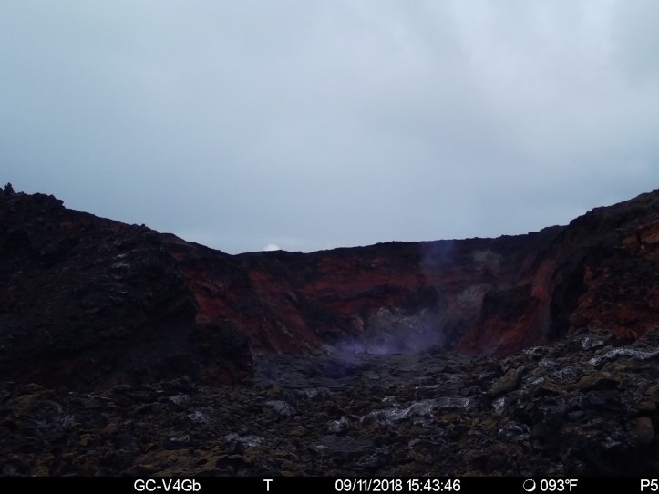
A good idea with the cyclone Olivia bearing down on them–visibility is going to be nil via other means. Also, there’s fresh lava in there…wonder what the rain/lava interactions will look like.
September 12, 2018, 8:30 a.m. Pacific: Ah, a night shot gives more perspective. The camera isn’t right in front of the crater opening but overlooking the crater–note the temperature, 97 degrees F, at 4 a.m. Kudos to the hardy earth scientists who placed this camera!
September 14, 2018: Well, this is a good sign, IMO (emphasis added):
HAWAIIAN VOLCANO OBSERVATORY DAILY UPDATE
U.S. Geological Survey
Friday, September 14, 2018, 10:06 AM HST (Friday, September 14, 2018, 20:06 UTC)KILAUEA VOLCANO (VNUM #332010)
19°25’16” N 155°17’13” W, Summit Elevation 4091 ft (1247 m)
Current Volcano Alert Level: WATCH
Current Aviation Color Code: ORANGEKīlauea summit and lower East Rift Zone
On Kīlauea Volcano’s lower East Rift Zone (LERZ), the collapse pit is the central part of a slowly subsiding lava surface that previously filled the fissure 8 cone. Minor incandescence is still visible overnight while minor fuming is visible during the day. What appeared to be a small slow lava flow yesterday was probably a layer of incandescence that was gradually exposed yesterday morning in the collapse pit. Since the beginning of September, small lava flows have been observed within the fissure 8 cone, however none have extended outside the walls of the cone.
Seismicity and ground deformation remain low at the summit of Kīlauea. Aftershocks from the magnitude-6.9 earthquake in early May are still being generated on faults located on Kīlauea’s South Flank. For the last few days, summit tilt seemed to be turning to weak inflation but weak deflation resumed two days ago (09/12).
Small collapses continue to occur within Puʻu ʻŌʻō crater generating dust plumes. Rates of tilting throughout the East Rift Zone are much lower than were observed during the period of major eruptive activity. There has been no change in seismicity during the past week.
Sulfur dioxide (SO2) emission rates at the summit, Puʻu ʻŌʻō, and LERZ are drastically reduced; the combined rate is less than 1,000 tonnes/day, which is lower than at any time since late 2007. SO2 emission rates from LERZ vents Tuesday (09/11) were below the detection threshold of the measurement technique
Maybe, just maybe, the residents of the Puna District and their authorities will be able to turn their attention to recovery soon.
In the meantime, volconologists are getting good information that may help many others in the future. I’ve read that one of their big unsolved mysteries is how a volcanic eruption ends.
September 17, 2018, 6:41 p.m., Pacific: A rainbow over the summit at one of the HVO webcams at the time of this writing:
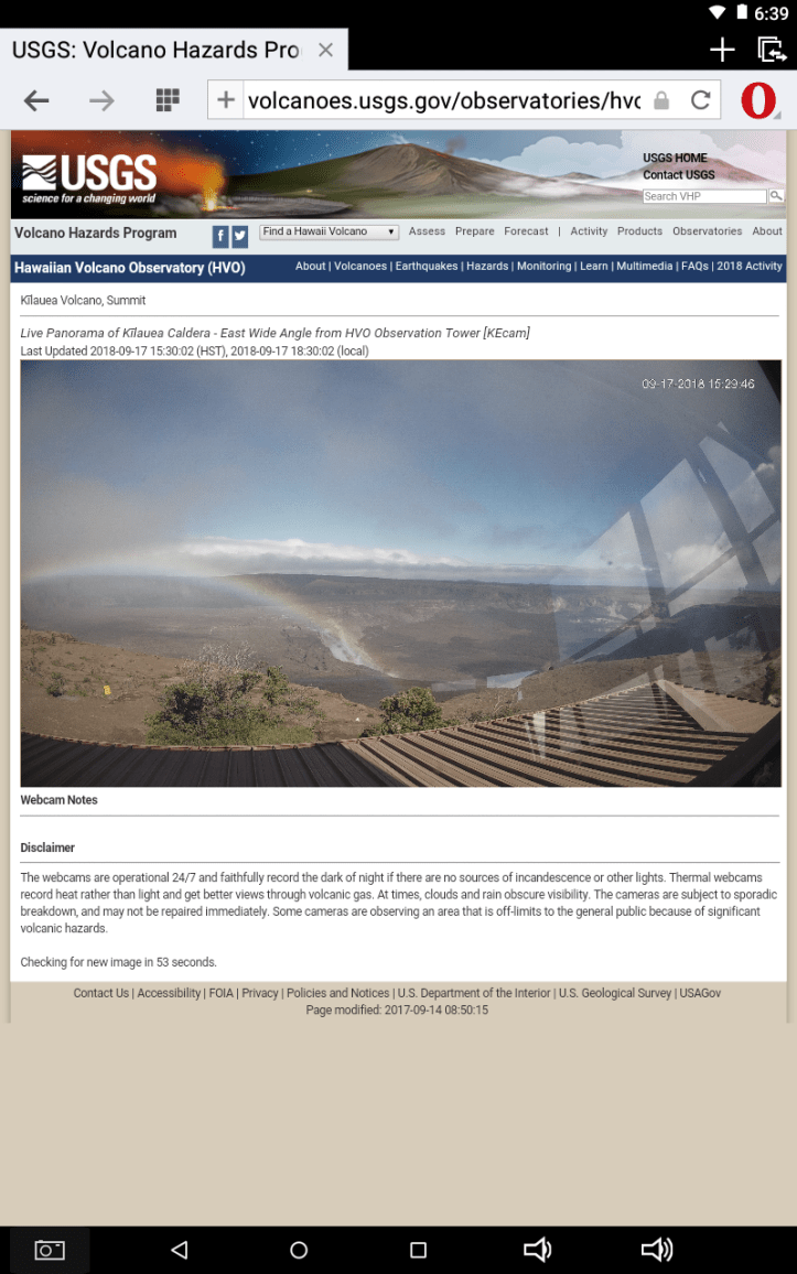
September 21, 2018: HVO published this yesterday in its “Volcano Watch” series:
Will this summer’s limited collapse of Kīlauea caldera eventually widen?
The limited collapse of the inner part of Kīlauea Volcano’s caldera this summer fell well short of the larger summit-wide collapses that occurred in the past. How many such limited collapses can we recognize at Kīlauea before written records were kept? The answer is none.
Yes, none. Without written descriptions, we could not identify past small-scale caldera collapses. The reason is that such collapses are confined to the inner part of the caldera itself, exactly where later eruptions and the next collapse take place.
The eruptions partly or completely fill the small collapse depression, and the next small collapse overprints the preceding one, like walking on someone else’s footsteps. We might get a geologic hint of repeated small collapses under favorable circumstances, but usually we are out of luck.
The much larger summit-wide collapses, however, can be identified with careful research. Such collapses are probably less frequent than the limited collapses. Between the summit-wide collapses there is time for, and good reason to expect, intervening explosive eruptions. These eruptions—powered by magmatic gas, steam, or both—deposit ash and coarser debris outside the caldera, creating deposits that form markers helping to distinguish one summit-wide collapse from another.
Putting together the evidence for such events is complicated, time-consuming, field-oriented research, but it paid dividends at Kīlauea by recognizing large-scale cyclic behavior of the volcano during the past 2,500 years.
Among other things, we learned that each summit-wide caldera collapse was followed by centuries during which the supply rate of magma to the ground surface was apparently low—only several percent of that for the past 200 years. As a result, only a few lava flows erupted from one of the rift zones outside the caldera.
Within the caldera, however, many explosive eruptions took place. Lava could have erupted in the caldera, but never with sufficient volume to fill the caldera and spill out to form surface flows. Eventually the supply rate increased, the caldera filled, and lava flows erupted along the rift zones. The volcano has been doing this for the past 200 years.
The previous two summit-wide caldera collapses occurred about 2,200 and 500 years ago, respectively. Each of these collapses was immediately preceded by the development of a very large flow field on the flank of Kīlauea.
These two flow fields, the Kīpukanēnē (2,200 years ago) and the ‘Ailā‘au (mid-15th century), are the largest that we know on Kīlauea in the past 2,500 years—the period of time for which we have good evidence. The eruption that formed the ‘Ailā‘au flow field lasted about 60 years; the eruption that formed the Kīpukanēnē flow field probably lasted several decades.
What could be the reason that eruption of a vast flow field preceded a large caldera collapse?
There are two end-member possibilities. One is that rapid melting of rock in the mantle came to an end, so that there was little magma coming up the pipe to replenish magma erupted in a large flow field. The other is that magma continued to ascend but was hijacked before reaching the ground surface, going somewhere else in or below Kīlauea.
What about the large Pu‘u ‘Ō‘ō flow field? That eruption lasted just over 35 years and accumulated a volume equivalent to that of the Kīpukanēnē flow field. That makes Pu‘u ‘Ō‘ō either the second or third largest flow field known in the past 2,500 years on Kīlauea.
Since each of the other two large flow fields immediately preceded a summit-wide caldera collapse, is the Pu‘u ‘Ō‘ō flow field sending a message? Will this summer’s small summit collapse eventually resume and ultimately engulf the entire summit?
The geologic evidence is insufficient to tell us how long it took for past large collapses to fully develop. Such collapses could have happened in only a few weeks or could have been spread over years to several decades.
In this light, this summer’s collapse could be all that will happen—or it could be the start of a longer period of repeated collapses that finally involve the entire summit. We simply can’t tell at this stage. It will probably take decades before we know if the size of the Pu‘u ‘Ō‘ō flow field was a harbinger of major collapse or only a red herring.
September 23, 2018: Hawaii Volcanoes National Park has reopened!
And the daily updates for the summit, Pu’u O’o, and the LERZ remain unchanged.
September 25, 2018:
We can't help but love this comparison of the #KilaueaCaldera using #KilaueaIki as a scale. 😍 https://t.co/Owjn4B3Tr4
— USGS Volcanoes🌋 (@USGSVolcanoes) September 24, 2018
https://platform.twitter.com/widgets.js
End of repost.
Here are some before-and-after pix the USGS posted:
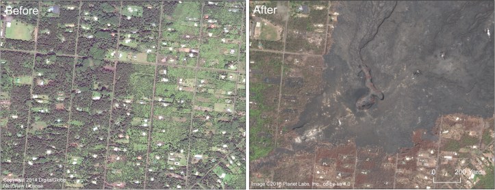
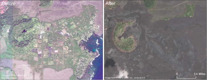
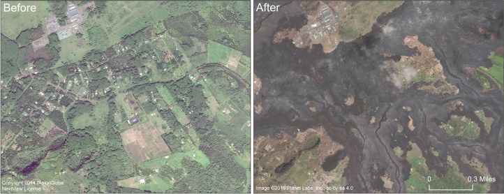
And here is a local landowner’s testimony during a recovery bill hearing:
It’s amazing that Earth produces these events, messing up everybody’s lives in the neighborhood, and then just settles down again as if it’s no big thing.
And it isn’t. Kilauea has had many eruptions in historic times. This was one of the larger ones, but it wasn’t a record-breaker, as far as I know.
Such is life on the third rock from the Sun. Catastrophes like this teach us how to enjoy the long spells of calm in between various kinds of storms that are part of this planet’s operating system.
So, today the Hawaiian Volcano Observatory reports that Kilauea is slowly inflating again, though no lava has appeared at the surface anywhere yet. In fact, Kilauea now sports a lake at the bottom of the summit crater that collapsed after the lava there drained away in May 2018!

It’s not the sort of lake you’d want to swim in. (Image: K. Milliken/USGS)
And nearby Mauna Loa is slowly heading towards an eruption, too, per HVO. These two volcanoes often erupt at around the same point in geologic time.
While the volcanologists watch and wait, Hawaii County is recovering.
A local citizen’s group recently celebrated the first anniversary of the eruption’s end by honoring local heroes.
No doubt small-town America, Puna District version, continues to respond in a variety of ways that range from leaving Hawaii forever to rebuilding on their former property as soon as the lava cools down.
What’s the “right” thing to do?
If there were only one correct way to handle these things, we’d all be doing that now or else have perished along the way.
The 2018 eruption in Kilauea’s Lower East Rift Zone shows, once again, that a major reason we have survived so long as a species is because of our flexible responses to such disasters.
So, a year after the eruption ended, Hawaiians affected by the eruption are working out their own solutions. And, in the background, Madame Pelee holds her breath for a moment in between violent exhalations.
Let’s all enjoy the peaceful interlude while we can.

I cant even begin to imagine watching something like that. Thanks for an amazing share.