
[sound of crickets chirping]
It’s surprisingly difficult to answer that question.
- In the above screencap of Indonesia’s online volcano monitoring graphic, Borneo (circled in white) is clear of any monitoring symbols. So, no?
- Officials in northeast Borneo are looking into a volcano tourism promotion for Tawau Hills National Park in Sabah. So, yes?
And here’s a related puzzle: Is this 13,000-foot-high mass of igneous rock, rising so dramatically above low-lying Borneo, a volcano?
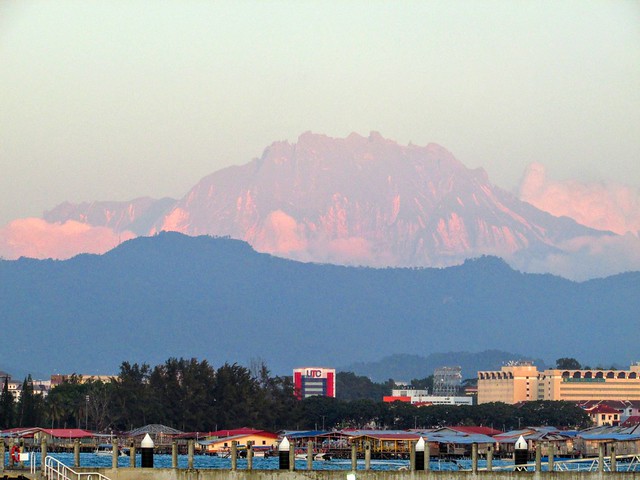
That we can answer: Mount Kinabalu — highest mountain in Southeast Asia and iconic Bornean tourist attraction — is a granitic pluton. It froze in place a long time ago, sort of like New Hampshire’s more extensive and much older White Mountains in the US. (Image: Jason Thien, CC BY 2.0)
This volcano/no volcano situation in Borneo would make a little more sense to us laypeople if all of Sundaland – the southeast promontory of continental Eurasia — was above the waves, as it has been for most of the last million years.
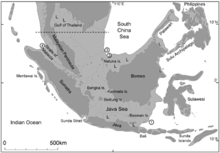
Seeing it as a single chunk of real estate, it’s obvious that the brightly colored circles and triangles in the monitoring graphic (quakes and volcanoes, respectively) cluster along Sundaland’s edges where tectonic plates interact today.
Sundaland’s interior, including the southern two-thirds of Borneo, is actually pretty quiet. (Hall, 2009)
Northern Borneo has an edgier history.
Pause the following video just before 10 Ma (million years ago), and Sundaland shows up very nicely.
As you can see, Borneo sticks out of the northern edge of Sundaland and has experienced some major changes over the last 45 million years thanks to the collision of India and Asia.
Lots of changes around Borneo, especially in the last 20 million years or so. Of note, see how there’s nothing but water around the Equator at the 100-Ma mark? That’s Tethys — its tropical waters encircled the planet back then. At times, shallow seaways on the continents also connected the Arctic Ocean to that warm-water flow. No wonder the world was a greenhouse!
The Sulu Archipelago
One of those major events left behind the ridge of igneous rock that we would see, stretching between northeastern Borneo and the Philippines, if sea level were a few hundred feet lower than it is today.

That’s the Sulu Arc.
Today it is a geologically quiet but lawless archipelago. Tens of millions of years ago, during the first half of the Miocene epoch, the Sulu Arc was an active subduction zone.
All that rock-and-rolling only lasted a few million years — just long enough to build a line of now-extinct volcanoes.
But what if those ancient subterranean fires are only MOSTLY extinguished?
Then, if it’s your job to improve the economy of Sabah, you start thinking about geotourism.
You see, northeastern Borneo is the southernmost part of the Sulu Arc. There are hot springs here, as well as a volcanic field that last erupted some 30,000 years ago at Bombalai Hill.
Not to mention these “conical sprouts” and other thermal features at Andrassy in Tawau Hills National Park.
In addition to this, there are lava beds at Mostyn, several miles from Tawau Hills Park.
These were laid down in fissure eruptions. Geologists aren’t sure when this happened; some experts put it as far back as 3 million years, while others can’t rule out the possibility that the fissures might still be active. (Macpherson et al.)
Whatever the exact date, no eruption has occurred on Borneo since the last ice age ended. Since this is the cut-off time used to define “active volcano,” it is true that Borneo has no known active volcanoes.
But northeastern Borneo does have hot springs and other signs of relatively recent activity that would interest volcano tourists, especially those who might not feel comfortable setting foot on an active volcano like Marapi.
At present, though, there’s no obvious reason why there might not be an eruption here some day, unlikely though that may be.
Monitoring northern Borneo
Earth scientists do keep an unofficial eye on northern Borneo. So far, they’ve found nothing worrisome.
Seismicity in the Sulu Arc is low, and seismic tomography shows no evidence of ongoing subduction here today. (Macpherson et al.)
The boffins are also very curious about what’s going on underneath northern Borneo.
North Borneo provides a unique natural laboratory for investigating post-subduction processes. It was the site of two subduction systems during the last 65Ma [the Sulu Arc and another one in the sea that existed before the current South China Sea formed. . . BJD]. During the post-subduction phase the western side of North Borneo has experienced mountain building, which formed the Crocker Range (~20Ma) and the 4100m high Mt. Kinabalu, a large granite pluton emplaced relatively rapidly between 7.9 and 7.2Ma.
While significant research has taken place to characterize the surface geology of North Borneo, the extent to which this has been shaped by post subduction tectonic processes remains unknown. Indeed, the processes that are occurring are contested . . .
This certainly sounds esoteric, but it has many practical applications.
For instance, what is now the San Andreas Fault, believe it or not, used to be a subduction zone.
Better understanding of subduction zone structure and how they “turn off” would certainly help geologists improve their assessment of the risks posed by such places today.
In 2018, seismologists deployed a network of seismographs across north Borneo.
The study will last two years and give geoscientists a much clearer idea of just what’s going on beneath this fascinating tropical island.
Sources:
Global Volcanism Program. 2013. Tawau Hills. https://volcano.si.edu/volcano.cfm?vn=269010 Last accessed July 19, 2019.
___. 2013. Mostyn. https://volcano.si.edu/volcano.cfm?vn=269814 Last accessed July 19, 2019.
Hall, R. 2009. The Eurasian SE Asian margin as a modern example of an accretionary orogen. Geological Society, London, Special Publications, 318(1): 351-372.
Hall, R.; van Hattum, M. W.; and Spakman, W. 2008. Impact of India–Asia collision on SE Asia: the record in Borneo. Tectonophysics, 451(1-4): 366-389.
Macpherson, C. G.; Chiang, K. K.; Hall, R.; Nowell, G. M.; and others. 2010. Plio-Pleistocene intra-plate magmatism from the southern Sulu Arc, Semporna peninsula, Sabah, Borneo: Implications for high-Nb basalt in subduction zones. Journal of Volcanology and Geothermal Research, 190(1-2): 25-38.
