
Those of us outside Hawaii may be a little off in our perception of the ongoing eruption at Kilauea Volcano:
Love this graphic from @HawaiiNuiBrew pic.twitter.com/ubyroplFYr
— Dr. Samantha Montano (@SamLMontano) May 23, 2018
The image on the left makes sense to anyone who has heard that the Big Island sits on a geological hot spot where molten rock leaks out of Earth’s mantle, forming a series of shield volcanoes.
What we’re missing is the fact that two different local macrofeatures–this mantle hot spot and the Pacific Ocean crust underlying Hawaii–are in constant motion relative to each other. With magma constantly upwelling from below, the end result is less like a conveyor belt of “Hershey’s Kiss” volcanoes and more like what happens when you try to spoonfeed an infant for the first time.
This is how, over the last million years or so, a total of five volcanoes have piled up above the waves together (with some help from submarine volcanoes Mahukona and Loihi) to form the Big Island.
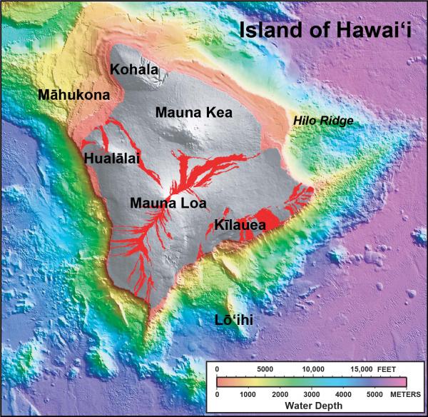
Three of these volcanoes are superstars:
- Kilauea, the current headline hog, is by no means the biggest Hawaiian volcano, although it is the most active one. In fact, Kilauea is one of the most productive volcanoes on Earth in terms of how much lava it erupts.
HVO (Hawaiian Volcano Observatory) Threat Potential: Very high.
Last eruption: Began in 1983, ongoing both at summit and in lower East Rift Zone. - Mauna Loa not only takes up over half of the Big Island’s area, it also is the largest active volcano on our planet.
HVO Threat Potential: Very high.
Last eruption: 1984. Currently building toward an eruption but nothing is imminent. Despite the coincidence of activity in the 1980s, Kilauea and Mauna Loa seldom erupt at the same time. - Mauna Kea–the one with all the observatories on top–is the second most massive volcano on the island. At almost 14,000 feet above sea level (over 4 km) it is also the tallest mountain in the state and the only part of Hawaii that sported glaciers during the last ice age. If you add in the other 20,000 feet (6 km) hidden underwater, then Mauna Kea is the highest mountain on Earth, towering some 4,000 feet (over 1 km) above Everest.
HVO Threat Potential: Moderate. (Those ultrasensitive observatories will detect magma moving into the volcano long before Mauna Kea actually erupts.)
Last eruption: 4,500 to 6,000 years ago.
Hualalai may not be a record-breaker, but it’s still the third most active Hawaiian volcano, and today its most recent lava flow underlies Kona International Airport and a lot of residential and resort property.
- HVO Threat Potential: High.
- Last eruption: 1801.
The fifth Big Island volcano, Kohala, may be extinct, but it has a claim none of the others can top–first!
How Hawaii’s Big Island formed
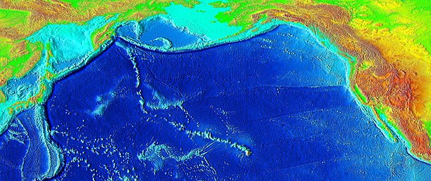
As I understand it, submarine operations at this Pacific hot spot began while there were still dinosaurs around, more than 70 million years ago. Down through geologic time, extensive lava flows built up one island after another, each of which slowly moved away from the hot spot, cooled down, eroded, and eventually sank beneath the waves again. The seamounts that remain today stretch far up into the northwest Pacific, though not all of them are considered to be part of Hawaii.
A word on terminology might be helpful here. “Hawaii” is confusing because it has two meanings:
- The Big Island’s actual name is Hawaii.
- With Wikipedian conciseness, the US state of Hawaii “encompasses nearly the entire volcanic Hawaiian archipelago, which comprises hundreds of islands spread over 1,500 miles (2,400 km). At the southeastern end of the archipelago, the eight main islands are—in order from northwest to southeast: Niʻihau, Kauaʻi, Oʻahu, Molokaʻi, Lānaʻi, Kahoʻolawe, Maui, and the Island of Hawaiʻi.”
Haleakala on Maui–technically, another Hawaiian volcano–is still active, but we’re just talking about the Big Island today.
It first appeared when lava flows on one-million-year-old Kohala Volcano broke the ocean surface 500,000 or more years ago.
A couple hundred thousand years after that, the eruption rate began to slow as Kohala moved away from the hot spot, thanks to plate tectonics, traveling a few more inches to the northwest every year. Eventually its erosion rate outdid that of lava resurfacing and the volcano died–probably. Its last eruption was many tens of thousands of years ago.
Today Kohala is very scenic, although so much has collapsed, washed away, or blown off in the wind that geologists aren’t sure exactly what this Big Island volcano used to look like in its prime.
Not long after Kohala erupted from the sea floor a million years ago and began inching away from the hot spot, construction on Mauna Kea began. These lava flows were voluminous, even covering part of Kohala! Then came Hualalai and, starting perhaps 700,000 years ago, Mauna Loa.
You can stand in one place today and look at all four fire mountains:
Remember, Kohala is extinct, Mauna Kea is sleeping, but Mauna Loa (the name means “Long Mountain”) and Hualalai both continue to be potential eruption threats.
Finally, Kilauea started up between 300,000 and 600,000 years ago, emerging explosively from the sea some 50,000 to 100,000 years ago.

The lava flows that have constructed the Big Island have also buried much of the land’s geologic history, but volcanologists have worked out some of the relationships between these volcanoes.
For a long time, given its location and relatively small size, everybody thought that Kilauea was just a vent on Mauna Loa, but now it has been established that they have different magma plumbing systems.
While I was live-blogging part of the May eruption, I saw a tweet from a reliable source that said Kilauea is actually more closely linked to Mauna Kea, just as up-and-coming Loihi volcanic seamount off the coast is linked to Kilauea. If I ever find that source again, I’ll document it here.
Anyway, Loihi isn’t expected to rise above sea level for at least the next 10,000 years and perhaps much longer. It’s too early to tell if it will become the sixth land volcano on the Big Island or if Loihi will become a new Hawaiian island.
Lava Hazard Zones
Kilauea’s 2018 activity, especially in the lower East Rift Zone, maps large in our minds because of the human catastrophe it has caused. Perhaps some good may come out of that by making people pay more attention to the state’s lava hazard zones.
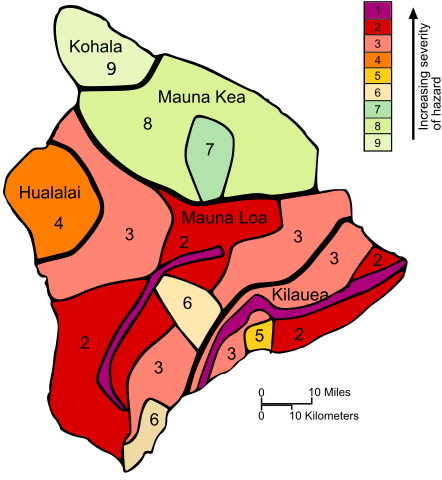
Many factors go into purchasing a home, and it’s easy during quiet times to overlook something that may not happen for tens to hundreds of years.
As one Leilani Estates (Zone 1) resident told reporters:
We kind of figured it would be like taking a walk when there’s a storm out. You could get hit by lightning, but you probably won’t.
According to this realtor, the value of properties situated in higher-numbered zones on the Big Island shouldn’t be affected by the Lower East Rift Zone eruption.
Still, that’s a map of very real hazards. There is some volcanic risk throughout the island. No doubt people in zones 1 and 2 everywhere are now thinking seriously about what to do if trouble happens. But those in other zones should also give it some thought.
Mauna Loa is slowly gearing up to another eruption. Hualalai probably still has fire in it, too. Emergency planners in Hilo are prepared–the city only narrowly escaped Long Mountain’s wrath the last couple times it erupted. Officials at Kona International Airport, which sits on land that Hualalai visited two centuries ago, probably have volcano emergency plans in place, too.
But what about everybody else?
Volcanologists are fond of saying that the most dangerous volcano is the one you don’t know is there. However, a close second must be the one that has been quiet for so long that everyone takes it for granted.
Things can change so fast! Foreknowledge, perspective, and some planning ahead can make any emergency easier to bear. This might also mean the difference between solvency and bankruptcy, or even life and death when one of the Big Island’s volcanoes next erupts.
Featured image: Earth Sciences and Image Analysis, NASA-Johnson Space Center via Wikimedia.
Sources:
Hawaiian Volcano Observatory. 2018. https://volcanoes.usgs.gov/observatories/hvo/ Last accessed May 25, 2018.
— . 2018. Actove volcanoes of Hawaii. https://volcanoes.usgs.gov/observatories/hvo/hvo_volcanoes.html Last accessed May 26, 2018.
—. 2016. Volcano Watch: A geological tour of the Hawaiian Islands (Hawai’i). https://volcanoes.usgs.gov/observatories/hvo/hvo_volcano_watch.html?vwid=317 Last accessed May 26, 2018.
Rubin, K. 2018. The formation of the Hawaiian Islands. Hawaii Center for Volcanology. https://www.soest.hawaii.edu/GG/HCV/haw_formation.html Last accessed May 25, 2018.
Wikipedia. 2018. Kohala (mountain). https://en.wikipedia.org/wiki/Kohala_(mountain) Last accessed May 25, 2018.
—. 2018. Mauna Kea. https://en.wikipedia.org/wiki/Mauna_Kea Last accessed May 25, 2018.
—. 2018. Hualalai. https://en.wikipedia.org/wiki/Hualālai Last accessed May 25, 2018.
—. 2018. Mauna Loa. https://en.wikipedia.org/wiki/Mauna_Loa Last accessed May 25, 2018.
—. 2018. Kilauea. https://en.wikipedia.org/wiki/Kīlauea Last accessed May 26, 2018.
