
We’ve seen that the two chief methods of flood control involve building barriers and keeping river channels open so they can hold as much water as possible.
How does that work out in real life? Let’s see how real-life flood control has been handled for:
- Dhaka, Bangladesh
- The Hull and Thames Rivers, United Kingdom
- Jackson, Mississippi
Dhaka, Bangladesh – riverine flooding
Disaster is the only image many of us headline-dependent outsiders have of Bangladesh.
So let’s take a little side trip first and learn why millions of people are proud of Dhaka, the capital city of this four-decade-old country.
How beautiful!
Now, here’s the bad news – three geographic reasons why Bangladesh floods every year:
- A huge river basin (map below is by Pfly). Some areas here average up to 188 inches of rain per year. The rivers must also handle Himalayan melt runoff during the monsoon season.
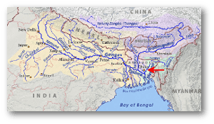
Note how most of that water passes near Dhaka to the east and west - Silty rivers (the Padma [Ganges], the Jamuna [Brahmaputra], and the Meghna) with clogged channels.

NASA - Lots of land-falling tropical cyclones.

Cyclone tracks from 1970 to 2005. The 1970 Bhola cyclone was the most notable of these for political, national, and meteorological reasons.

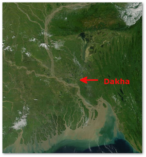

Dhaka sits on the eastern bank of the Buriganga River, about 200 miles from the sea, in the central region of the largest river delta in the world. Its climate is fairly dry from November to April. Droughts in Bangladesh don’t get the same news coverage as floods, but they do happen.
The water comes during monsoon season, from May through October, when Dhaka gets almost ninety percent of its almost 80 inches of yearly rainfall.
Here’s a short clip of monsoon rains in Dhaka – imagine it happening almost daily for months at a time:
About 18% of the country gets submerged each year. People die and property is lost, but there are benefits, too. Annual flooding brings fertile sediment to overworked fields, reduces soil salinity, and recharges ground water.
So what happens in Dhaka, where the land is elevated on average about 13 feet above sea level and the population density is well over 100,000 people per square mile?
Flood control experts see the city as Dhaka West (where most of the city’s people live) and Dhaka East:
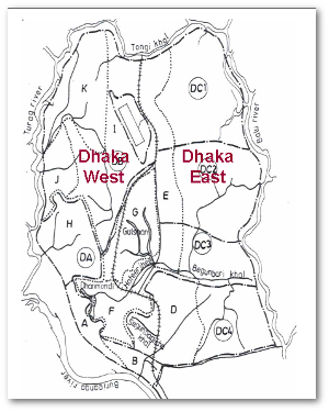
Dredging silted river channels is too expensive for Bangladesh to do very often, so Dhaka West is protected by barriers (embankments, raised roads, flood walls), regulators and sluice gates, and pump stations. Sparsely populated Dhaka East is a designated flood flow zone. It has retention ponds and 40-50 canals to store water than channel it back into the river as the flood subsides.
The city’s flood control measures were tested during the extreme flooding of 1998 (PDF). Seventy-five percent of Bangladesh was flooded, and Dakha East was submerged under some seven feet of water for many weeks. About eighty percent of Dakha West remained dry. Where it did flood, the water was at lower level than the flood outside.
Dhaka West’s defenses withstood other extreme flooding in 2004 and 2007, too. However, there are problems. The main one is that when you build barriers strong enough to keep water out, they will also keep water in, especially if your storm sewers and other drainage systems haven’t been upgraded in a long time as is the case in Dhaka.
Flood control experts say (PDF) that this internal flooding is now a worse hazard for the city than riverine flooding.
Another problem is that Dhaka, one of the world’s biggest cities, continues to grow. Land is at a premium and slums are being built on and wearing down embankments. People and industries are also moving into Dhaka East, reducing the area available for flood water retention ponds and canals as well as increasing the at-risk population.
Dhaka East is currently unprotected from floods, but storm sewer/drainage system improvements have been proposed, as well as raised roads, embankments, flood walls, and improvement and protection of the canals and water retention areas.
top
Coastal flooding: The UK tidal barriers on the Hull and Thames rivers top
On December 5, 2013, a powerful extratropical cyclone blew a North Sea storm surge up the Humber Estuary in northeastern England during high tide. Coastal flood waters poured into the river, but much of the surge was stopped by a tidal barrier system built in 1980 to protect the city of Hull.
As you can see, it was close: the surge got up to 5.8 meters, beating a 1905 record of 4.7 meters. The barrier system tops out at 6 meters.
Almost all of Hull sits below high tide levels. Parts of the city still flooded that night, but 19,000 homes were reportedly saved.

The December 2013 coastal flooding was the worst seen since the 1953 North Sea floods in which over 2,100 people died, mostly in the Netherlands.
Southend, on the Thames Estuary, saw a record-high tide of 4.1 meters then. Further up the estuary and river, at London, the famous Thames Barrier was repeatedly closed and open with the cycling tide and successfully protected central London from the highest tides seen there since the barrier was built in 1983.
We saw at Dhaka that internal flooding happens when water inside a barrier can’t get out. This doesn’t happen along the Hull and Thames rivers.
During especially bad riverine flooding there, the sea barriers are closed at low tide. This turns the river channel into a catchment that stores upstream flood water for later release.
This video shows it in operation. Enough flood waters have been stored behind the Thames Barrier to equalize water levels on either side, so now they’re opening the barriers (each one has to be opened separately):
top
Jackson, Mississippi – riverine flooding and social conflict top
In Dhaka and the UK, the public has rallied around the measures mentioned above. Not so in the parts of the US states of Mississippi and Louisiana through which the Pearl River flows.
There, flood control proposals ignited ongoing controversies that only settled after the US Army Corps of Engineers decided to maintain the status quo, that is, pretty much the same flood control that was in place on Friday, April 13, 1979:
First, the Corps decided that a dry dam would be the best flood control project to prevent a repeat of the 1979 disaster. President Reagan authorized the Shoccoe Dry Dam project in 1986. Residents upstream from the proposed construction site complained that it would disrupt agricultural and timber lands and that many of them would lose their homes and property. The Mississippi state legislature turned down the project in 1987.
In 1989, ten years after the Easter Flood in Jackson, the Corps undertook another flood control study. The study was completed in 1996 and recommended 21 miles of new levees to supplement existing ones that had been overtopped in 1979. The state legislature turned it down, saying “the plan does not offer additional economic development opportunities and could cause increased flooding south of the Jackson area.”
The Corps made the same recommendation in 2007. It was rejected for the same reason.
Between 1996 and 2010, three dam/retention/development projects were proposed by developers. The Two Lakes, LeFleur Lakes, and Lower Lake plans ignited a firestorm of protest from Louisianans (the Pearl River forms part of the border between Mississippi and Louisiana).
The out-of-state people were already upset about the effects of an existing dam on the Pearl at Jackson and now complained to the Corps of Engineers that more dams and other changes proposed in the flood control projects would cause disruptive cycles of water rationing and pulses. As well, they argued, it would harm wetlands and threaten marine life, especially commercial oyster beds, by changing water levels and salinity.
Meanwhile, back in Jackson, other construction projects conflicted with the proposed flood control lakes. Local environmentalists also claimed that these lakes would endanger rare species like the ringed sawback turtle and the Gulf sturgeon.
In 2010, the US Army Corps of Engineers simply recertified existing levees along the Pearl for ten more years. The Corps noted that this did not mean that the levees would completely reduce flood risks.
Humanity is capable of very impressive engineering feats, but that’s not all flood control requires. Measures have to include public opinion. At the same time, everybody has to make some compromises for flood control to work.
In the case of the Pearl River, nothing much has has changed since 1979.
Nobody has won anything after all that expensive studying and debate. Instead, everybody stands to lose something all over again, the next time the river floods.

Did you like this post? Feel free to tip me via PayPal. Any amount is welcome, and thank you in advance!

More information:
Dhaka
- Performance of Flood Control Works Around Dhaka City During Major Floods in Bangladesh (PDF). Sujit Kumar Bala et al., Second International Conference on Water & Flood Management, 2009. Bangladesh University of Engineering and Technology
- Flood Forecasting and Warning Centre. Bangladesh Water Development Board
- Assessment of adaptation measures against flooding in the city of Dhaka, Bangladesh (PDF). Anika Nasra Haque et al.
- Dhaka. Wikipedia
- Floods in Bangladesh. Wikipedia
- Geography of Bangladesh. Wikipedia
Flood Management in the Flood Plain of BangladeshMizanur Rahman et al.
United Kingdom
- The east coast Big Flood, 31 January–1 February 1953: a summary of the human disaster. Peter Baxter
- Thames Barrier. Environment Agency
- Thames Barrier. Wikipedia
- Risk Nexus. After the storm: how the UK’s flood defences performed during the surge following Xaver. Zurich
Jackson, Mississippi
- Corps certifies Pearl River levees. Associated Press.
- Lessons of the 1979 Easter Flood. Jackson Free Press
- A Review of Flood Control Options for the Jackson Metropolitan Area, 1979-2010. Mississippi Legislature
- 1979 Pearl River Flood Event Summary. National Weather Service Jackson
- Pearl River Flood Control Measures Ignite Controversy. Niki L. Pace
- Projects, Studies & Reports. Pearl River Basin Development District
- Swamp Fight: LA & MS forces battle over flood protection. WVUE.
