
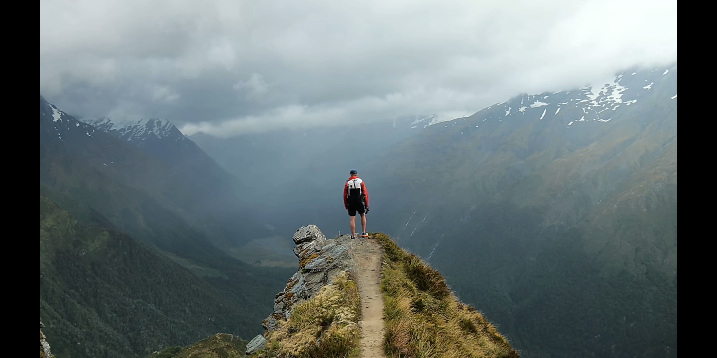
South Island (ice but no fire) — A screenshot of the hiking video from last time.
Until reading up for this “VEI 8’s” post, I didn’t fully realize how hazardous Taupo supervolcano is (although there’s no need to obssess over the closely monitored research magnet) OR how amazing both Taupo and New Zealand are.
How to address both?
The post naturally divided itself in two, with the first part focusing on general background information and details about New Zealand’s South Island, along with the inevitable LOTR references.
Those were natural, even though some locales shown in the Lord of the Rings movie — Mount Doom and the Mordor landscape — were actually filmed on North Island, where the volcanoes are.
🌋🌋🌋
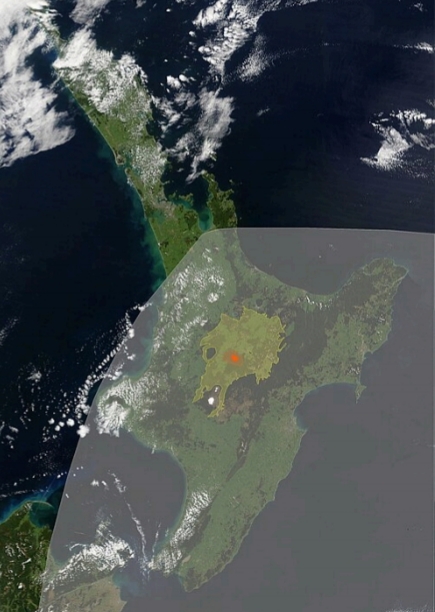
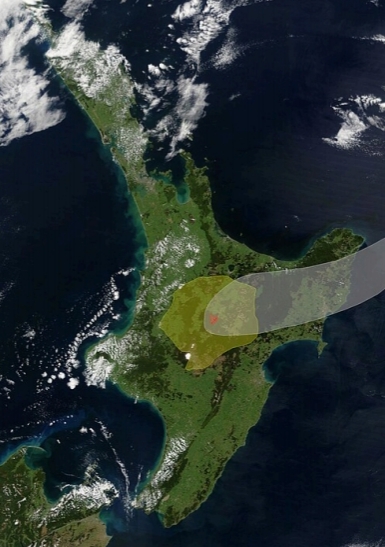
Just south of big Lake Taupo, in the southernmost part of the Taupo Volcanic Zone, stand Tongariro and Ruapehu.
Here they are in relation to Taupo, as seen from the north in a low-orbit satellite image:

NASA via Wikimedia, public domain
Notice how flat the land is around Lake Taupo?
That flatness was caused by an enormous pyroclastic surge in or around 230 AD during Taupo’s second most powerful eruption in the past 26,000 years. It was also Earth’s most powerful eruption during the last five millennia. (Barker et al., 2021; Lowe and Pittari; Mestel et al., 2025, is the source of the 230 AD date throughout this post)
Sauron, by the way, does not lurk in the lake.
Horomatangi does.
🌋🌋🌋
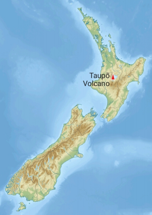
Welcome to North Island — and Taupo supervolcano!
Why are all of New Zealand’s volcanoes on North Island?
That and more are coming up in this post — along with Horomatangi and the indigenous people who are the lake’s legal custodians and who know that this spirit monster lives in it.
Horomatangi lurks in a submarine lair that is located near where, according to Western science, Taupo’s present magmatic system sits…
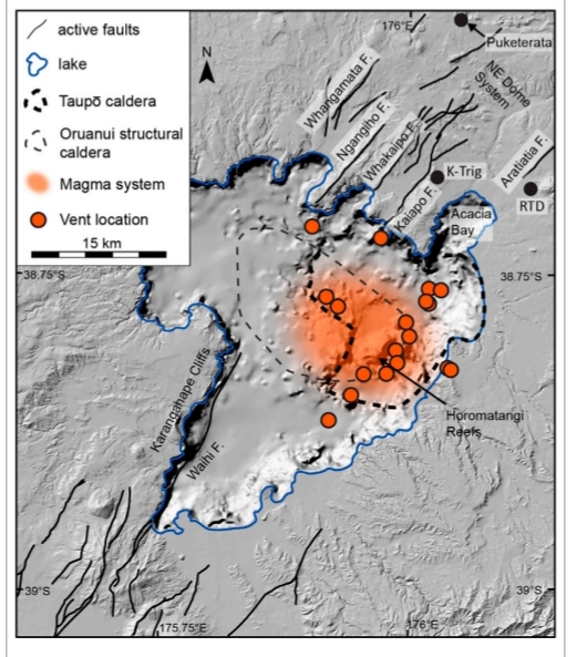
Figure 2 by Muirhead et al. (CC BY-NC-ND 4.0).
…that big red area in the above figure.
This looks alarming; however, it’s just a 2D illustration.
Reality here has three dimensions.
The top of Taupo’s extensive magma system — much of which is likely crystalline right now (Barker et al., 2021; Ellis et al.; Muirhead et al.) — is thought to be several miles underground, below the general area on the lake floor that is highlighted red in Figure 2. (Muirhead et al.)
Taupo is a restless caldera…
…but a dormant one at present.
Nevertheless:
- A series of lava domes (some of the red circles illustrated in Figure 2 up there) erupted here, in a more or less straight line, shortly after the ~230 AD catastrophe. (Barker et al., 2021; Lowe and Pittari; Wilson et al., 1985) These submerged rhyolite domes now are popularly known as the “Horomatangi Reefs.”
That was Taupo’s most recent eruption, almost two thousand years ago (a very short time in geological terms), and the area still shows some geothermal activity and occasional ground deformation.
🌋🌋🌋
- “Oruanui,” on that Figure 2, refers to Taupo’s last supereruption, ~25.5 thousand years ago. On the graphic, light dashes outline a gravity anomaly that presumably is the 1½-mile-deep Oruanui caldera. (Barker et al., 2021; Muirhead et al.; Wilson et al., 2005)
Taupo has had at least four of those babies over the last 330,000 years, according to Mestel et al. (2025), in addition to many, many lesser eruptions from various vents. Some of these were no bigger than Ruapehu’s blasts in the 1990s. Others were larger than that (although nowhere near supersized), spanning several orders of magnitude. (Barker et al., 2019, 2021)
Most supervolcanoes, including Yellowstone, do mostly have “normal”-sized eruptions, as well as a Big One now and then, but Taupo is very productive. And its broad range of eruption sizes doesn’t follow any recognizable pattern, which makes forecasting Taupo’s activity quite challenging. (Scott et al.; Wilson et al., 2021)
🌋🌋🌋
- The heavy dashed line on Figure 2 marks a smaller caldera that formed in or around 230 AD during the previously mentioned catastrophe that flattened much of central North Island.
“Taupo” is one name for that eruption. Another is “Hatepe.” Since we will be going into it in detail in the next to last section, and just to keep things easy to follow, let’s call it the Y eruption, which is used by Lowe and Pittari, based on the name of its stratigraphic layers in Taupo’s geologic record.
🌋🌋🌋
- Also note “Acacia Bay” on the graphic up above. Taupo Town, which we will visit by video in the Risk section, is at the head of Acacia Bay.
🌋🌋🌋
But wait. There’s more!
Taupo had twenty-seven smaller explosive eruptions in between those two biggies, Oruanui and Y — twenty-five of them (counting Y) in the last twelve thousand years. (Barker et al., 2021)
I told you it was productive!
If that seems like fast work — well, it is, especially during the first few millennia after a supereruption.
This layperson’s general impression is that there is a recovery period when more sedate supervolcanoes reestablish their plumbing system after the big blast and its accompanying physical changes (like caldera formation). (See Wilson et al., 2021, for example, on the gap between Yellowstone’s Huckleberry Ridge and Lava Creek supereruptions; they do, however, note differences in recovery period length at various supervolcanoes.)
Not so at Taupo.
It started erupting again just a few years after the supereruption — explosively, too, though on a MUCH smaller scale — and its magma chemistry shifted. Taupo was already resetting its magmatic system! (Barker et al., 2021)
Taupo is a fast worker. (Wilson et al., 2005)
That’s just one of the reasons why Taupo is considered a Very High Threat volcano. (Lamb et al.)
Why does it do that?
Scientists from a variety of earth science fields are trying to find out.
Modeling Taupo
The good news is that eruption products from its many blasts give geoscientists very useful “snapshot” clues as to how Taupo’s plumbing has evolved over time. (Bachmann and Huber; Wilson et al., 2005)
They have a much larger dataset to work with than, as far as I know, what is available for the other supervolcanoes in this blog series.
Among other benefits, all those “snapshots” of Taupo’s magma reservoirs just prior to eruption improve the reliability of computer modeling studies like the one that we are going to look at near this post’s end.
In that model, Barker et al. (2019) describe five hypothetical future Taupo eruption scenarios.
However, Taupo is surprisingly complex, and we will need to know a little more about it and its two major eruptions, Oruanui and Y, before we get to those scenarios, which actually are just one small step on the road to full understanding of Taupo and its hazards. (Barker et al., 2019)
Volcanologists all agree that a lot more research is needed to better understand Taupo and, ideally, to develop reliable forecasting of its next move.
The rest of us just need an introduction since Taupo supervolcano isn’t yet as internationally famous as Yellowstone.
🌋🌋🌋
The inferred eruption cloud and pyroclastic flow deposits from Taupo’s Oruanui supereruption. (Image: ChaseKiwi via Wikimedia, public domain)
“International recognition? I can get that.” — the volcano.
Thanks, Taupo, but it’s not necessary. Go on back to sleep.
“K. For now.”
🌋🌋🌋
The Y eruption
There is a fact-based animation of the Oruanui supereruption coming up later, but for comparison right now, here is an image showing the inferred eruption cloud and pyroclastic flow deposits for Taupo’s Y eruption about 1,800 years ago:
ChaseKiwi via Wikimedia, public domain)
Of course, this cloud was much smaller — the Y eruption involved about 35 km3 of magma versus Oruanui’s 530 km3 or more (Allan et al., 2017; Barker et al., 2021; Lowe and Pittari; Muirhead et al.; Wilson et al., 2005, 2009) — but note that the Y eruption’s pyroclastic flow was more extensive than Oruanui’s.
We’ll explore that incredible Y eruption in more detail at the end of this post, saving it for last because, well, it was even more awesome than the supereruption was.
Right now, it’s time for that introduction to Taupo supervolcano.
🌋🌋🌋
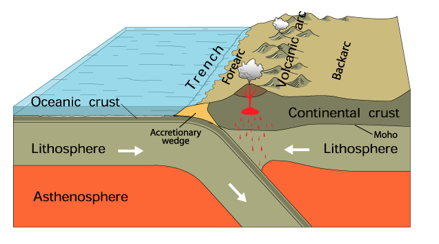
Where the volcanoes are
On New Zealand’s South Island, powerful tectonic forces cause a continental collision that is pushing up the Southern Alps, which we can all agree, after watching Harmen Hoek’s hiking video last time, are GORGEOUS!
A different but equally powerful tectonic event is shaping North Island: subduction. (Barker et al., 2021)
The Taupo Volcanic Zone (TVZ)
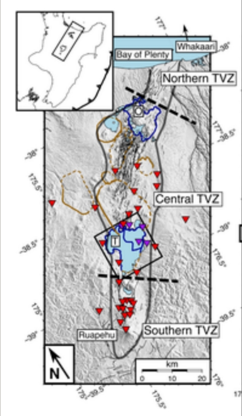
Fire and ice: North Island’s Taupo Volcanic Zone, by Illsley-Kemp et al., Figure 1 (CC BY-NC-ND-SA 4.0). Red triangles are seismic stations; brown and purple outlines mark the many caldera volcanoes here, past and present.
Going into a little detail, on this Figure 1 by Illsley Kemp et al. an inset shows the subduction trench as a dark line with triangles pointing in the direction of the downgoing slab — towards North Island and the Taupo Volcanic Zone (TVZ).
Other geological events have had a hand in constructing North Island, but it’s no coincidence that the TVZ formed where it did, a little way in from those triangles (graphic) and the trench (real life).
That’s about the right distance for a bunch of subduction-zone volcanoes a volcanic front, which is what the Taupo Volcanic Zone is. (Corella Santa Cruz)
The front shows where rising magma from the subducting slab, many miles below the island, has reached the surface.
This is how all subduction zones work, actually, but there are some peculiarities here.
Questions about the TVZ
In New Zealand’s case, the basic subduction model does not explain:
- Taupo’s hyperactivity (Barker et al., 2021) there in the center of North Island.
- Why the Central TVZ is so explosive, as shown by its many calderas, with some of the older ones being bigger even than Taupo. Technically, the Central TVZ can be described as one big caldera complex (Barker et al., 2021; Potter et al., 2012; Wilson et al., 2005), which is not a typical subduction zone feature.
- Why the Oruanui supereruption started and then stopped for several months before restarting: strange behavior, when hundreds of cubic kilometers of magma, loaded with gas (Allan et al., 2012), are beginning to come out! Did something turn off the burgeoning supereruption and then turn it back on?
Can Earth do that?
(Spoiler: Yes, Allan et al., 2012, suggest. It needs some explaining but is worth it — what awe-inspiring force could put a supereruption on hold?)
- This, particularly the lower two images:
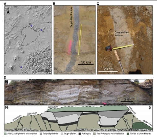
Muirhead et al., Figure 8, CC BY-NC-ND-SA 4.0.
Per Muirhead et al., the top three images of that Figure 8 show Taupo and two places where ground cracked apart and was filled with ash during the Oruanui supereruption.
The bottom two images show amazing ground displacement associated with the ~230 AD Y eruption, which was accompanied and followed by what must have been horrendous earthquakes. (Lowe and Pittari; Wilson et al., 1985)
Takeaway point: The ground didn’t necessarily crack open because of these eruptions (although that often does occur in any major eruption). The Oruanui and Y eruptions might have happened because the ground cracked open! (Allan et al. 2012, 2017)
“Might.”
Nobody yet knows for sure how tectonics (i.e., the cracks/earthquakes) and volcanism interact in the TVZ, but it’s not for lack of trying.
Since there is risk on North Island to three-quarters of New Zealand’s population and much of its GDP, geoscientists are thoroughly investigating possible tectonics-magmatism links here, producing many papers, etc., that I could only sample a little bit for this post.
🌋🌋🌋
The human point of view
Are you starting to feel concerned about Taupo?
Well, it certainly is no place for sensationalism.
Western science
Rather, the Taupo region is a wonderful, livable place that also happens to require — and gets, from New Zealanders with a science-oriented point of view — a no-nonsense, solutions-oriented approach to volcanic hazard identification and risk mitigation.
Think of how Harmen Hoek tackled the Southern Alps in that hiking video — it reminded me of the way New Zealand’s scientists, government officials, emergency management specialists and others tackle Taupo’s hazards in the papers, articles, and sourcebook that I have read, which is a very small fraction of all the Taupo literature that is out there.
This, together with the tectonic power that raised those Southern Alps, is why I included the video in these posts.
However, there are other New Zealanders living around Taupo, and there is another point of view.
The Maori
Those indigenous custodians of Lake Taupo — the Maori, whose permission is needed to install monitoring instruments in and around the lake — do not think in terms of hazard. (Gabrielsen et al.)
Video is from last month (read the whole thing).
🛶🛶🛶
To the Maori, according to Gabrielsen et al., volcanoes are a part of nature and therefore count as ancestors.
The Maori believe that volcanoes should be free to express themselves, just like humans.
I don’t know where Horomatangi fits into that world view, but the monster does appear to be recognized as a danger specific to a part of the spiritual ancestor Taupōmoana (Lake Taupo) that secular scientists are especially interested in.
In general, though, the Maori believe that we humans should simply keep away from areas where the volcano throws things when it is angry. (Gabrielsen et al.)
Taupo has not erupted since the Maori arrived in Aotearoa New Zealand, back in the 1300s to 1400s.
As you might expect, there is some culture clash between the Maori and the scientific viewpoints on Taupo. (Ellis et al.)
Fortunately, in New Zealand nowadays there also is respect for the Maori and their way of life.
This hasn’t always been the case, and scars from the colonization era are still tender.
Nevertheless, I think (layperson speculation only) that both viewpoints are starting to work together in the face of such sizable hazard lurking under that beautiful lake, however one’s cultural background may influence its description. (See, for example, Gabrielsen et al. and Mestel et al., 2025a)
For this post, I will follow Western science, but we will hear from the Maori again, later on.
🌋🌋🌋
Why is Taupo so unusual?
It all has to do with subduction, somehow.
Here’s the big picture as this layperson understands what is going on (mostly underground).
Magmatism
USGS, public domain
Off the eastern coast of North Island, as that subducting slab of basalt seafloor (the Pacific oceanic plate) starts down into the planet’s interior, it gets squeezed and heated up. It then begins to sweat out magma and other fluids (water-based ones as well as gases that are under such high pressure down there that they have become fluid).
Then, as this fiery “sweat” rises off of the slab and percolates through cracks and along fault lines in the overlying crust, it experiences less and less pressure (because there is less and less rock holding it down as it moves up toward the surface).
When the overburden pressure drops enough, water content turns into steam, while the formerly dissolved gases become volatile (“gassy”) again.
MONUSCO, at Nyamulagira, DR Congo, CC BY-SA 2.0
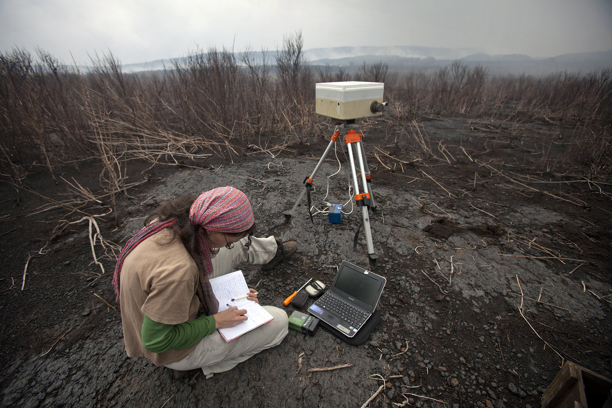
Meanwhile, up at the surface, if monitoring instruments are present, volcanologists may start seeing more earthquakes and some ground deformation, both caused by the rising “sweat.” Heat flow might increase, too, and there likely will also be detectable changes in gas emissions and groundwater chemistry.
The scientists then will notify everybody that an episode of unrest is underway. (They did this most recently at Taupo in 2022.)
Miles underground, where the action is, this rising slab “sweat” often stalls out. In that case, the episode of volcanic unrest has ended. (During the last episode, this was announced at Taupo in May 2023.)
Volcanic unrest doesn’t always result in an eruption — but every eruption is preceded by unrest. (Acocella et al.; Wilson et al., 2021)
Sometimes that slab “sweat” keeps rising, its chemistry continuing to change as the hot melt reacts with whatever rocks it meets along the way.
Buoyancy continues to increase. Everything rises faster and faster. This turns into a runaway process, and then: BOOM!
Per YouTube translation, he’s out there enjoying nature and the waterfalls; things get real, and he cusses, when Calbuco volcano up there erupts. Then — pro tip — he doesn’t stand there recording it; he very sensibly gathers up his things and heads off, perhaps to higher ground since some pyroclastic flows follow stream drainages (really bad ones, however, ignore topography and can cross drainages).
It typically is a boom, too, rather than pretty flows of runny red lava.
Hawaii and Iceland are famous for such “tourist eruptions,” but their mafic volcanism is associated with something different: hotspots.
In subduction zones, magma tends to be silicic and erupts more explosively.
The TVZ’s most common magma type is very explosive, indeed.
Rhyolite
In subduction zones, geology has lots of water to play around with.
Good old H2O does several things here, including (but not limited to):
- Making rock melt faster
- Providing volatiles
- Making molten rock sticky enough to hold in those volatiles, just as a sturdy bottle, when sealed, holds in both soda and dissolved
bubblyCO2. - Separately from the back-arc basin business, subduction of this thick ocean-plateau segment stretches and strains the center of North Island. This also is a major contribution to the formation of Taupo Rift, described above.
- An enormous amount of water comes out of the equally enormous downgoing seafloor Hikurangi basalt slab. This water acts as a flux, lowering melting temperatures and producing a lot of “sweat” underground and, ultimately, a lot of rhyolite volcanism as well as geothermal areas up at the surface.
- Ash fall that, among other things, can irritate human tissues; clog and contaminate water bodies ranging from the Waikato River to pet and livestock water bins and home rain-collection rooftop systems; fry power grids and home electronics; destroy machinery like automotive engines, hydropower turbines, and jet engines; pollute vegetation and livestock feed with nasty chemicals like fluorine; reduce visibility; and make roads and other lifelines too slippery to use.
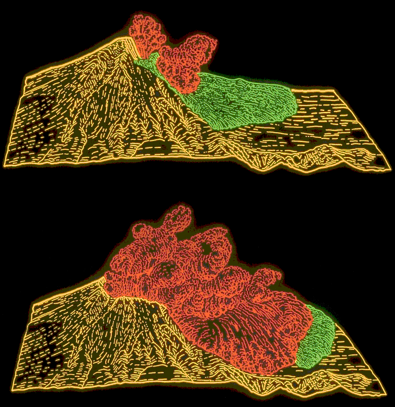
- Falling rocks. With rhyolite for muscle, an angry volcano can throw big rocks a long way, as shown in the earlier Chaiten video.
Here is another example:
- Gases. This is a hazard even when there’s no eruption underway, particularly around geothermal areas.
Odorless CO2 is heavier than air and collects in low points that are either natural or manmade. Other common and potentially deadly volcanic gases are hydrogen sulfide (burnt-matches smell) and sulfur dioxide (rotten-egg smell).
- Water effects. Steam explosions do occur in the geothermal fields and are unpredictable. (Potter et al., 2012)
Also, because of the lake, any eruption at, say, the Horomatangi Reefs will be phreatomagmatic (a result of magma and water coming into contact).
Because of its crater lake, Ruapehu’s eruptions in the 1990s were phreatomagmatic but comparatively small:
A phreatomagmatic eruption is not only spectacular but also extends the ashfall hazard by making particles small enough to carry over long distances. (Allan et al., 2017)
It can also rain mud when steam in such an eruption plume condenses back into water.
In addition, tsunamis and large waves have occurred on Lake Taupo during periods of unrest.
Most recently, there was an 8-inch tsunami during the 2022-23 unrest episode. (Lamb et al.)
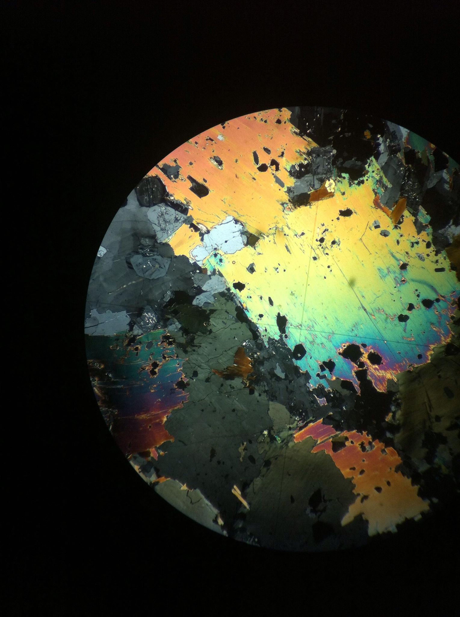
Shattered magma shards — this is from a very old mafic magma called tonalite — are very pretty under the microscope, and the crystals tell petrologists much about their otherwise inaccessible parent magma body. (Image: Alice Staro (distributed via imaggeo.egu.eu), CC BY-SA 3.0)
Gas and steam, however, are continuing to form as pressure on the rising magmatic “sweat” lessens. Eventually the sticky magma can’t take it any more and shatters. (Cashman and Sparks; Oppenheimer)
What happens next, if there are sufficient amounts of magma and gas, is exactly what happens when you uncap a shaken soda bottle, and for the same reason (Oppenheimer): the dissolved gas suddenly comes out of solution, the fluid magma foams up — pumice is hardened rock foam (New Mexico BGMR) — and BOOM!
At Mount St. Helens in May 1980, an earthquake caused a landslide, which really did uncap the “bottle”! (Image: T. R. Alpha/USGS via Wikimedia
Central TVZ magma, however, is capable of epic restraint. That’s because most of it is rhyolite, which doesn’t shatter easily.
As a result, pressure builds and builds. (Potter et al., 2012)
When the breaking point is finally reached, the resulting eruption is tremendous.
Chaiten, 2008, Chile
Rhyolite eruptions are rare on the human time scale, fortunately.
However, the Central Taupo Volcanic Zone is the most productive center of rhyolite volcanism on Earth. (Barker et al., 2021; Lowe and Pittari; Muirhead et al.; Potter et al., 2012; Wilson et al., 2005, 2009)
That explains all the holes in the ground calderas there.
But there are also a lot of active geologic faults in the TVZ, all aligned in the same direction.
Figure 2 by Muirhead et al. (CC BY-NC-ND 4.0).
Muirhead et al. even labeled some of them in Figure 2.
Do they have anything to do with Taupo and the TVZ?
They do indeed.
These faults are clues pointing toward what Allan et al. (2012) call the “invisible hand” that they believe can both trigger and pause TVZ eruptions, including the Oruanui supereruption.
✋🚦✋
It’s very invisible and, at first and even second glance, seems unrelated to volcanoes —
Rifting
Basin and Range: Classic continental rifting in western North America. (Image: IRIS Consortium)
This happens when land gets stretched beyond its breaking point.
The stressed-out ground eventually fractures into roughly parallel faults. Land in between those faults then subsides and forms a valley (a/k/a a basin).
Of course, it won’t subside very much if there is lots of molten rock underneath it, as is the case in any subduction zone.
The result: a back-arc basin, with the “arc” being that volcanic front we mentioned earlier, in between the basin and the trench.
Or so it goes in the textbooks. Earth itself, of course, comes up with some beautiful variations on this theme.
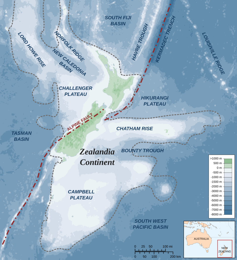
However, the TVZ is a special case — in part, because of Zealandia.

Remember the continent of Zealandia, outlined in pink? (Image: Wikimedia, public domain)
The big dark-blue “tail of the comma” in the upper right part of that image is the magnificently named Tonga-Kermadec-Hikurangi Trench. (Corella Santa Cruz)
See the line of bumps along its left edge? That is the volcanic front, and those bumps include the Tonga and Kermadec island arcs. (Ballance et al.)
What looks like a big flat valley to the left of those? That’s a back-arc basin. (Ballance et al.)
Now follow that narrowing basin all the way down to Zealandia, where it seems to end by pointing at central North Island.
It doesn’t really end; tectonic plate collisions are too powerful to stop just because a continent is in the way.
Instead, things get complicated.
Among other features, the continental Taupo Rift forms, with major help from an unusual situation at the trench, as we will soon see.
Now we’re talking cracks in the ground, active faults, earthquakes…with the power of a tectonic plate collision behind it all.
If anything could stop a supereruption that was just getting underway, it would be something like that! (Allan et al., 2012)
Alright, rifting. We’ll see that “invisible hand” at work in the Oruanui Supereruption section, which is next.
But the huge volume of rhyolite magma needed to fuel Taupo’s hyperactivity, and caldera-forming eruptions elsewhere in the Central TVZ — it comes from where?
The Hikurangi ocean plateau
There is a lot going on here, but check out the Hikurangi Plateau and its position relative to North Island. (Image: Alexrk via Wikimedia, CC BY-SA 3.0)
This big pile of basalt is riding the Pacific oceanic plate down into that subduction trench located just off North Island’s eastern coast.
The ocean plateau makes this part of the subduction slab very thick, compared to the Tonga and Kermadec subduction slabs. (Corella Santa Cruz)
Experts describe — in excruciating detail! — how this unusual slab thickness, plus the Pacific plate subducting at an angle (Mestel et al., 2025; Muirhead et al.), affect the TVZ in many ways.
Most of it is way over my head. But I understand Muirhead et al. to report that:
🌋🌋🌋
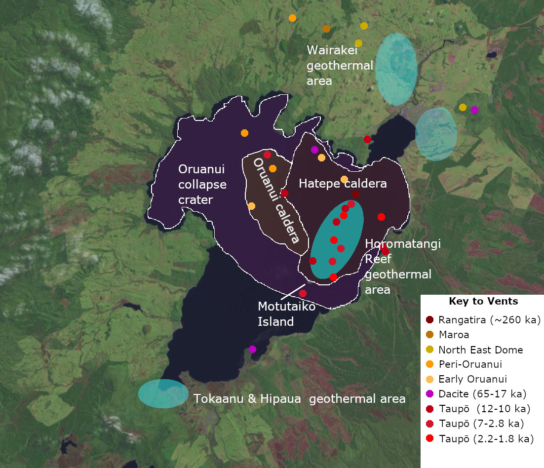
Blue ovals show the active geothermal areas around Taupo. The two areas north of Lake Taupo are commercially exploited for energy and it’s important to note for the next section that they are associated not with Taupo but with the North East Dome Complex a few miles away. (Barker et al., 2021; Image by ChaseKiwi via Wikimedia, public domain.
🌋🌋🌋
That’s why there is so much heat and magma available in the Central Taupo Volcanic Zone, along with plenty of cracks for the melt to come up through and explode (violently, more often than not, because of the rhyolite).
Now let’s tie this all together with an eruption.
A big one.
🌋🌋🌋
Taupo’s Oruanui supereruption
The following animation is a fact-based recreation of the supereruption, produced by the Museum of New Zealand Te Papa Tongarewa.
There is a lot of information packed into it, too.
And, from reading, I’ve learned a few additional and equally fascinating facts about the Oruanui supereruption that can’t be shown because they are occurring underground.
For orientation, we are watching from the north, similar to that low-orbit view of Tongariro and Ruapehu earlier in this post.
Indeed, the first eruption plume in the distance (as well as the last one in this animation) is from the area of those two South TVZ stratovolcanoes, although I don’t know which one erupts. They are, of course, still active today.
Lake Huka
That’s old Lake Huka at the start.
It was much larger than Lake Taupo (which is not small) and had been present for almost a quarter-million years before the supereruption destroyed it.
Huka’s shape, like that of the present southern Lake Taupo, follows the fault lines of the Taupo Rift.
TVZ volcanism before Oruanui
In the animation we see that the ground around Lake Huka, some fifty-four thousand years ago (when the video starts), is quite Mordor-like, with pyroclastic deposits and lava domes from Central TVZ volcanism that has been ongoing for roughly two million years. (Barker et al., 2021)
It’s a reminder that today’s Taupo and an active caldera complex fifty miles north of Taupo are not unique; they are only the most recent TVZ volcanic centers.
This is a very complex region, but I believe the Oruanui animation shows us the general south rim area of gigantic but ancient Whakamaru caldera.
The North East Domes
That second eruption in the animation is not Oruanui, either.
It’s the North East Dome Complex, sounding off a couple of millennia before the Oruanui supereruption begins (Barker et al., 2021) — and in which the North East Dome magma will play a hidden role, per Allan et al., 2012, thanks to rifting.
A spasmodic supereruption
From the third eruption on, it’s Oruanui.
Tying things together: See the pause between the first and second Oruanui phases that we mentioned above? (The museum puts a lengthy pause between the second and third phases, too, although I can’t find that one mentioned in the papers I’ve read — an admittedly limited, though well cited sampling.)
✋🚦✋
Allan et al. (2012) suggest that a rifting episode set off Phase 1, and therefore the supereruption.
This initial episode, according to them, released tension and the ground then relaxed, sealing off the magma reservoir. The eruption stopped.
That’s amazing!
The ground may have relaxed, but there also must have been great force available to hold back this supereruption — especially after it had started.
Whatever kept the Oruanui magma in the ground after the Phase 1 eruption — [layperson speculation] probably force or forces related to plate tectonics (as described earlier) [/layperson speculation] — had to hold down huge upward forces powered by steam and degassing, buoyancy of an enormous mass of molten rock, heating and softening of the crustal containment, etc.
Anyway, it held. For months, Allan et al. (2012) report.
Tension gradually built up again, since plate tectonics never takes a break, and another rifting episode then reopened that vent, leading to the Phase 2 eruption.
According to this museum animation, that second phase was followed by a pause, too.
A more or less runaway process then began soon after the third Oruanui eruption, which came from a different vent.
It all sounds arcane and academic until we realize what actually happened: Plate tectonics put a supereruption on hold. For months!
🌋🌋🌋
For future reference, something similar happened during Yellowstone’s Huckleberry Ridge supereruption 2 million years ago, with Basin and Range continental rifting, rather than subduction, probably supplying the plate-tectonics muscle there.
🌋🌋🌋
Precursors (and a note on uncertainty)
More tying things together: Supereruption precursors are the ground swelling and fumaroles shown in this animation (there likely also were earthquakes and geochemical/geophysical changes that modern monitoring equipment would pick up long before the lake turned green).
Since precursors are not preserved in the geological record (Potter et al., 2012; Pyle), and no supereruption has ever been scientifically observed, what the museum shows happening before eruptions is hypothetical, but it is credible.
Based on real-time observations of “normal”-sized restless and erupting volcanoes today, the arrival of magma near the surface (watch the animation’s fiery lines below) could deform ground and make it steam just before that North East Dome eruption, and even more so before the first Oruanui blast.
What that does to vast Lake Huka (also hypothetical) shows the scale of the involved earth processes.
Today’s monitoring would detect changes before events reached the lake-closing stage — if supereruption precursors are like those seen with “normal” eruptions.
That’s a big “if,” but there is no obvious reason yet, according to all my reading, to suppose that precursors wouldn’t be the same, only bigger.
There should be some warning (Self, 2006), and the earlier the better.
This gigantic magma reservoir probably formed in just centuries to a few millennia (Cashman and Sparks) — a blink of geologic time and even measurable on our time scale.
Generally speaking, most magma bodies just sit there and soon harden in place, but when a pathway opens while the chamber contains eruptible melt, that magma — even if it’s sticky rhyolite — can come up very quickly. (Ellis et al.; Muirhead et al.)
Humanity needs as much time as possible to prepare for this.
But how would you like to be the people doing the monitoring, who have to announce that a supereruption appears to be on the way?
The docudrama Supervolcano accurately conveys the pressure and uncertainty of such a situation. (Klemetti; Miller and Wark)
It would be rough on other decision-makers, too. In that unprecedented situation, who would find it easy to call for an evacuation of, at least, North Island — an evacuation possibly lasting for decades or longer after a major Taupo blast?
And because of the complicating factor of rifting, there would be no guarantees of how things would turn out –whether or not the whole thing would stall out, exactly how much time we had (how fast the magma would rise), precisely how big that eventual eruption would be, and so forth.
Let’s hope such a testing time never comes in our lifetime or in that of our children.
Before we move on to what isn’t shown in the museum’s video, there is one more cool thing to see in the Oruanui animation video —
Magma “chambers”
The fire below: Hikurangi and the rest of the descending slab are too deep to be seen — instead, the animation shows where that magmatic “sweat” actually reaches the surface.
Detailed discussion of supervolcano plumbing is for the experts, but here is what this layperson sees, in light of her reading.
First, also out of sight, that “sweat” has first trickled up into a lower reservoir of hot but probably crystalline mush.
Only the top of this mush reservoir is shown — at the bottom of the museum’s video.
The new and much hotter material from below has melted some reservoir crystals, and now we see that remobilized magma trickling up into separate magma bodies that gradually merge into a single upper reservoir, which then gets supersized.
This upper reservoir feeds the eruptions and eventually evacuates sufficiently for the ground above it to collapse into the Oruanui caldera.
🌋🌋🌋
Now, what isn’t shown — the museum did a terrific job, but of course they can’t show every detail.
Here is some additional information learned from my reading.
That rumbling sound
In part, that rumbling is the caldera collapsing.
But something else is collapsing, too, even though we don’t see it.
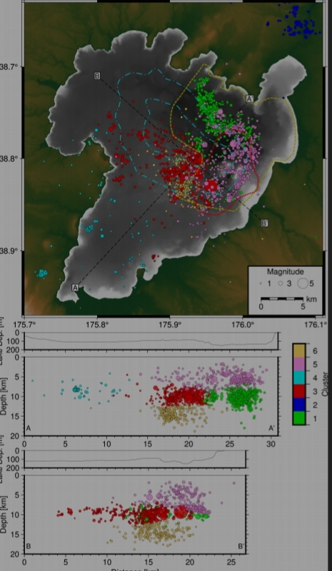
The light blue lines in this Figure 4 by Lamb et al., CC BY-NC-ND-SA 4.0, show the roughly 26,000-year-old Oruanui caldera’s outline as inferred from gravity anomalies. (The dark gray color shows Lake Taupo’s deepest part AND the Y eruption caldera (yellow dotted line) that formed about 1,800 years ago. The Horomatangi Reef geothermal field is outlined in red, and Lamb et al. also included seismicity from the 2022-23 unrest episode — the topic of their paper.)
During the supereruption, what is now the bed of southern Lake Taupo also collapsed — “sub-Saharan Africa,” according to the lake’s unusual shape.
It’s not clear to me from the reading whether this collapse was purely tectonic or was associated somehow with volcanism.
There is a geothermal area at the lake’s southern tip today, but some researchers suggest that there is no magma under south Lake Taupo. (Mestel et al., 2025)
Muirhead et al. even compare southern Lake Taupo to one of the great African rift lakes, Tanganyika!
Nevertheless, I notice that, in some papers, graphics of Taupo leave the Oruanui caldera’s southern border open.
And Barker et al (2021) call the collapse a volcanotectonic event.
Research into southern Lake Taupo is ongoing. That might be why the museum chose to do this animation from the north.
No clear boundaries
There are other signs of tectonic rifting during the supereruption besides that “invisible hand.”
For instance, as we saw earlier, ground cracked open in some places and was filled with Oruanui ash. (Muirhead et al.)
The most amazing evidence of possible rifting, though, might never have been spotted if there wasn’t a color difference between Oruanui eruption products, which are white, and those of the North East Dome Complex, which also are white but contain dark specks of biotite. (Allan et al., 2012)
To make a long story short, according to Allan et al. (2012), in the first and second Oruanui stages, North East Dome magma mixed with Taupo’s in Taupo’s conduit!
A crack must have opened up between the two volcanoes as part of a rifting episode that also controlled the Oruanui eruption’s early phases. (Allan et al., 2012)
That is, it did this if Taupo and the North East Dome Complex really are two separate volcanoes — another big “if.”
They certainly seem to be separate, being almost ten miles apart and having chemically different magma, which implies separate magmatic systems. (Allan et al., 2012)
But if cracks can connect them and they erupt simultaneously from the same vent — and with two geothermal fields on the northern shore of Lake Taupo might be getting their heat from the North East Domes — where exactly does Taupo volcano leave off and the North East Dome Complex begin? (Barker et al., 2021; Scott et al.)
Not only that; during the Oruanui supereruption, while the North East Dome Complex was crossing boundaries, Taupo itself was also stepping out.
That is, some of Taupo’s Oruanui magma left the main vent area and traveled 12 miles north before erupting far from any of the other vents. (Barker et al., 2021)
No wonder the Global Volcanism Program calls Taupo difficult to define!
Barker et al. (2021) sum up these uncertainties in their Figure 11 (no Creative Commons license). They also write that;
…The area that qualifies as Taupō volcano has…clearly evolved through time…The magmatic system beneath the present day lake has been responsible for the vast majority of recent volcanism and defines the roots of what is most widely recognised as Taupō volcano, largely because of the dominant collapse caldera structure defined from gravity data…The majority of young Holocene vents [those erupting since the last ice age ended, while Oruanui occurred just as that ice age was entering its final “big chill”] are located on the eastern side of the lake, as is the modern 200 MW geothermal system on the lake floor…We consider that these vent sites and the area of caldera collapse that occurred during the 232 CE Taupō eruption best represents the modern ‘Taupō volcano’ and the focus of current magmatism. This area also encompasses the region in which seismicity associated with unrest episodes that likely have magmatic origins [sic]…However, it is important to emphasise that future volcanism around Taupō could plausibly occur across a broader region than that which directly overlies the current focus of magmatism, given the wide area over which volcanism has demonstrably occurred in the geological record…
In other words, Taupo volcano likely will continue to evolve over time, thanks to the complex interactions here between rifting and magmatism.
What a dangerous neighbor for the 4 million or so North Islanders who live within a couple hundred miles of this supervolcano and its deceptively serene lake!
No doubt these doughty humans inhabit bunkers and go to work, school, or play with hard hats on and a survival kit in their backpacks?
Not so much, actually.
🌋🌋🌋
Risk
Volcanic risk = People + Hazard. (More detail on hazard and risk)
People
Taupo’s human neighbors collect awards:
Risk is not addressed in this video, but signs of both hazard and people are shown. Congratulations on the award, though! I’ve never been there, but Taupo Town looks like a nice place.
Each year more than a million tourists come here to enjoy the region…
🚲🚲🚲
…by land:
🛩🛩🛩
…by air:
Nice though brief view of, I think, snow-topped Tongariro volcano in this.
🎣🎣🎣
…on the water.
Lake Taupo is world famous for its trout fishing.
🛶🛶🛶
Some take the Kapu Maori Beat Challenge…
There is also singing…
They don’t allow embedding, but you really should watch this. Make sure the speakers or headset is on, too — it’s beautiful!
…and a form of dancing that seems to be working its way up into aggravated assault and battery (again, no embedding, but lots of fun to watch!):
Which is actually its original purpose. Haka was a traditional Maori way to get psyched for a war (and to psych out their opponents). I daresay it still is, but war is not now on the board. Now haka is an internationally renowned dance (and pregame warm-up in rugby, a sport that also verges on assault and battery).
I like to think that volcanologists do a haka before heading out for fieldwork on any volcano.
Brave and bold and fun-loving as they are, New Zealanders will always need to have certain stuff, which is also vulnerable to volcanic disruption.
🚗🏡💡🚰
Along with the geothermal energy plants north of Lake Taupo, there are multiple hydropower dams on the Waikato River, which drains the lake, supplying electricity to upper North Island, where most North Islanders live. (Wikipedia; Potter et al., 2015)
The river also is their main water source.
Hazards
Taupo’s hazards, up to a certain point, are the same as those from other New Zealand volcanoes.
These include, but are not limited to:
🌋🌋🌋
🌋🌋🌋
🌋🌋🌋
🌊🌊🌊
Eight inches doesn’t sound like a very big tsunami, but even this small a wave, combined with the M5.7 earthquake that spawned it, as well as the ground deformation that typically happens during unrest, can disappear a beach and otherwise do a number on the fragile young Taupo soils formed since the Y eruption.
That eruption 1,800 years ago produced deposits so thick that local rivers still wash down some of Y’s pumice whenever they flood (GeoNet); this apparently also happens when the lake is disturbed, as that “roving reporter’s” video shows.
The November 30, 2022, tsunami on Lake Taupo traveled inland as much as 131 feet in some places. (GVP; Lamb et al.; Lowe and Pittari)
🌋🌋🌋
Just a relatively small phreatomagmatic eruption from Taupo would cause major disruption for North Islanders. (Barker et al., 2019, 2021)
But will the next one be small?
The chance of any eruption at Taupo is less than 0.1% each year (Barker et al., 2019, 2021), but theoretically, anything could occur whenever Taupo does go off again. (Barker et al., 2019)
It might be another small eruption, like twenty-four of the twenty-five blasts that Taupo has had over the past twelve thousand years. (Barker et al., 2021; Lamb et al.)
In that twenty-fifth eruption, however, Taupo went far beyond “typical,” though without approaching supereruption levels.
The complexity and scale of that eruption make it difficult for volcanologists to accurately forecast the size, nature, and timing of the next inevitable eruption here. (Wilson et al., 1985)
🌋🌋🌋
The Y eruption
Two of the biggest potential hazards at any volcano are earthquakes and pyroclastic flows.
These would be local hazards during even a small Taupo eruption.
In fact, because hundreds to thousands of years can pass in between eruptions while unrest episodes occur much more often (about once every ten years or so), earthquakes are the most likely short-term hazard that people face in the TVZ. (Muirhead et al.)
I didn’t include quakes and fiery death clouds in the earlier list of hazards because the extremes that both reached during the Y eruption deserve special mention.
This was Taupo’s last eruption thus far, and it was very different from all the others that have occurred since the Oruanui supereruption some twenty-six thousand years ago.
The Y eruption produced the Horomatangi Reef lava domes, but mostly it was an explosive event.
How explosive?
There is “phreatomagmatic,” and then, very occasionally, there is “sublime and terrifying beyond belief.”
Krakatoa, 1883, reached that point. So did Hunga Tonga-Hunga Ha’apai, in January 2022.
The day before Hunga Tonga’s big blast.
Going by Lowe and Pittari’s description, Taupo also reached that point with its eruption in or around 230 AD.
Let’s see that eruption through their eyes.
In general, their version of this almost two-millennia-old catastrophe matches those given in other sources.
However, I don’t know whether the consensus that Y occurred in late summer to early fall also extends to the time of day for its climactic pyroclastic surge, which flattened most of central North Island.
Lowe and Pittari infer that this surge happened in the late afternoon, based upon insect assemblages that were preserved in a forest blown down by the surge and then buried in a peat bog because all the pre-existing stream drainages in central North Island were changed (including that of the Waikato River, which used to follow a different course).
Except where noted, the following description of the Y eruption, including the names of phases, is from Lowe and Pittari, who believe that the whole thing took anywhere from several days to several weeks.
It’s in abbreviated form from my notes because anything I could say would just dilute the impact of the events that Lowe and Pittari describe.
Of note, humans were present in Australia and New Caledonia at this point, but they had not yet reached Aotearoa New Zealand.
Luckily for them.
Phase 1 (Y1)
Relatively minor. Cold water mixing with magma over a few hours. Column about 10 km (6.2 miles)
Wilson et al. (1985) describe this phase as minor initial phreatomagmatic activity.
Phase 2 (Y2)
Increased intensity. Hatepe plinian, mostly magma driven. Average moderate-sized plinian, column ~30 km (18.6 miles). Some pyroclastic flows.
In the words of Wilson et al. (1985), this was a dry-vent plinian outburst, i.e., magmatic rather than steam-driven.
Phase 3 (Y3)
Wet. Hatepe phreatoplinian. Vent widening. Lots of water into rising and erupting gas-charged magma. Steam. Mud rain. Y3 eruption deposits show that wet sticky mud draped over branches of shrubs and trees as it fell. Described as typical or even archetypal phreatoplinian event. Few to tens of hours. Interrupted at least once by brief dry plinian activity.
Break of hours to fewer than three weeks.
Intense rainfall at one point, from ejected water, condensed steam, and/or weather. Two breaks during and after, of uncertain duration. They [Lowe and Pittari] also mention phases 3 and 4 possibly erupting simultaneously from separate vents.
According to Wilson et al. (1985), water eventually stopped this phase of the eruption, although large amounts of water continued to be ejected from the vent area. They (Wilson et al., 1985) suggest that the eruption paused for several hours to several weeks.
Phase 4 (Y4)
Phreatoplinian Rotongaio ash. New vent opens. Abundant lake water encounters shallow dome of degassed magma. As in Y3, eruption products land wet.
Phase 5 (Y5a and Y5b)
Taupo plinian (Y5a). Abrupt switch to dry and extremely powerful eruption. Near-extreme intensity. At least 11 moderate to small pyroclastic flows (Y5b) from vent overflow or column collapse. Most pumice blown out to sea. Column height 30-40 km (19-25 miles), near top of plinian range.
Phase 6 (Y6)
Taupo ignimbrite.
Catastrophic collapse of column from vent widening/ground subsidence that generates new caldera.
Drastic change in eruption conditions.
A roughly 30 km3 pyroclastic surge: 600-900 kph (373-560 mph), faster near vent, out to about 80 km (50 miles) in all directions. Still moving at more than 100 m/s (224 mph) at outer limits. Stopped only when ran out of material. Covered about 20,000 km2 (7,720 square miles) in 7-15 minutes.
Temp up to 500° C (932° F)
Near frictionless basal region.
Momentum took it over Tongariro (1,978 m/6489 feet above sea level) and the Kaimanawa Range (up to 1,727 m/5,666 feet), but not over Ruapehu (2,797 m/9,176 feet). And it did not slow down one bit while doing this.
Jetted material thrown forward supersonically as a result of violent expansion of ingested air.
Carbonized about 1 km3 of timber. Forests up to 170 km (106 miles) away were damaged and fires burned for several decades.
As for earthquakes, this ground used to be fairly flat —
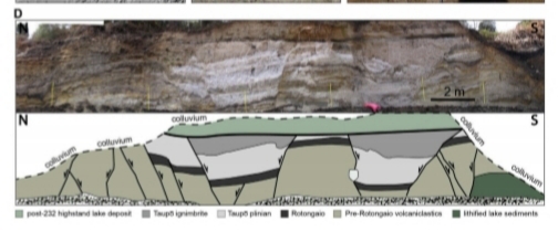
Remember this, from Muirhead et al., Figure 8, D and E? (CC BY-NC-ND-SA 4.0)
— as you can tell by matching up that black layer in Figure 8E, and the light-colored Y eruption ash that covers it.
What a rough ride that would have been!
Not that there was any life likely to be present — Muirhead et al. suggest that this ground faulting occurred during or immediately after the eruption.
According to Wilson et al. (1985), widespread and locally severe shaking occurred during but mostly after the eruption. It was associated with subsidence in the Lake Taupo basin.
[Layperson speculation] It sounds as though TVZ rifting and magmatism once again interacted, in complex ways, at the time of Taupo’s Y eruption. [/layperson speculation]
Y7, YZ: The Horomatangi lava domes
Lowe and Pittari suggest that Lake Taupo took an estimated ten to thirty years to refill after that terrible last explosive phase.
Also during the first decade or so, rhyolite lava oozed out of the new caldera from a series of vents that follow the Taupo Rift’s general alignment.
These now form the Horomatangi Reefs and the Waitahanui Bank, which isn’t labeled on this image — the youngest eruptive material at Taupo and the site of active geothermal activity.
Layperson comment
The paper by Lowe and Pittari came out in 2021, yet their description of the Y eruption reminds me of Hunga Tonga-Hunga Ha’apai in 2022, which also had typical eruptive activity — Surtseyan rather than plinian, and over a much longer period — until suddenly becoming intense and then culminating in that astounding explosion on January 15, 2022.
Lowe and Pittari, in 2021, even suggested that pressure waves from the sudden collapse of Taupo’s Y5a column caused a global meteotsunami — an academic word that we are all familiar with now because of the one that Hunga Tonga-Hunga Ha’apai generated in 2022.
Krakatoa also caused a meteotsunami in 1883, according to information collected by the Royal Society.
Krakatoa’s lethal pyroclastic flows traveled unusually far, too. Although not as terrible as Taupo’s Y6 flow, they did cross the broad Sunda Strait and traveled for some distance inland while still powerful enough to kill and injure many people. Krakatoa’s tsunami waves reminded one survivor of a row of hills on the move. (Winchester)
This is purely layperson speculation, but I wonder if the Y eruption’s unusual violence happened because some unique circumstance allowed water to play an unusually large role in it, as was probably also the case at Hunga Tonga-Hunga Ha’apai before the big blast in 2022 and, perhaps, at Krakatoa in 1883.
What exactly goes on, underneath the waves and locked into a fiery mass of magma and some physical phase or chemistry changes of H2O, that ultimately enables a seafloor volcano to “shotgun blast” the ionosphere or a caldera in central North Island to bury whole mountain ranges and cover 20,000 km2 of land in less than fifteen minutes?
🌋🌋🌋
Mitigating Taupo’s risks
Well. The lake is still there. The volcano is still there.
As with any volcano, the lengthy quiet spell since the Y eruption ended (lengthy, that is, on a human-relevant scale) might mean that the volcano is recharging but that current conditions aren’t right for an eruption. (Giordano and Caricchi)
Barker et al (2021) note that millennial-scale quiet spells at Taupo, like the one now, usually are accompanied by a change in Taupo’s magma chemistry and eruptive behavior.
They suggest that Taupo might still be in a recovery phase from Y but that 1,800 years is long enough for this hyperactive volcano to have moved into a new and unpredictable phase.
Sigh.
Obviously the only sensible way to deal with Taupo is to evacuate the whole North Island preventively, possibly South Island, too, and just let Nature take its course.
H. sapiens, though, is rarely sensible. And since we’re still here after hundreds of thousands of years, we must be doing something right.
In the human approach to Nature’s challenges, New Zealanders use their minds, as well as the wonderful spirit that Harmen Hoek embodied in his hike across the Southern Alps, to secure themselves on their beloved land as best they can.
The Maori carve Ngātoro-i-Rangi into Taupo ignimbrite to watch over the lake…and them.
Scientists monitor Taupo in every way possible, although Maori permission to install lake-bed instrumentation has not been granted. There also are technical and financial challenges for such a project. (Ellis et al.; Mestel et al., 2025)
Scientists make suggestions about ways to mitigate volcanic risk at Taupo, for instance, Section 2.3 of Potter et al. (2012).
As far as I can tell, from this very limited perspective thousands of miles away and with only the World Wide Web to consult, those suggestions have yet to be acted upon.
There is no overall hazard map for Taupo, as there is for some other New Zealand volcanoes.
Given Taupo’s variability, how could there be?
However, Barker et al. (2019) have modeled ashfall scenarios for Taupo eruptions of various sizes.
They say that it is only a simplified model and does not yet include all important features of a Taupo eruption, such as pyroclastic flows and lake water/magma interactions.
But it’s a start.
See their paper for details. In general, the model shows that smaller eruptions — in the range of many of Taupo’s post-Oruanui blasts — would likely cover central North Island with more than 1 cm (0.4 inch) of ash.
Moderately large eruptions — something the size of Mount St. Helens, 1980, or a little bigger — are modeled as bringing more than 1 cm (0.4 inch) to major population centers throughout North Island.
No reliable data are available on the rate at which Taupo’s really big eruptions might spew out tephra — a key factor in plume height and, therefore, ashfall coverage. (Cashman and Sparks)
For the hypothetical big events, Barker et al. (2019) estimated mass eruption rates for Tambora, 1815, (total volume about 30-50 km3 of magma, per Gertisser and Self) and the Bishop Tuff supereruption (coming up two posts from now) to model hypothetical Taupo blasts from around 50 km3 up to a 500 km3 supereruption.
According to their model, that sort of Taupo activity would lay down a damaging layer of more than 10 cm (4 inches) of ash across most of North Island and the top of South Island.
The experts compared their supereruption model results to the real-world Oruanui pattern and found a general match, although Oruanui’s deposits were shifted to the southeast.
A little good news: Per the model, Auckland and Wellington are the least likely major urban centers to experience significant ashfall in the first three lower-level scenarios.
Scenarios 4 and 5, of course, would be major national and international crises.
🥼🤝🛶
In terms of other studies, some Maori are scientists, too.
These individuals have facilitated discussions between geoscientists and their own people, who have lived around Lake Taupo for 34 generations and who forbid placement of any monitoring equipment on the lake bed, part of which is a lid on the current active magmatic system. (Ellis et al.; Mestel et al., 2025a)
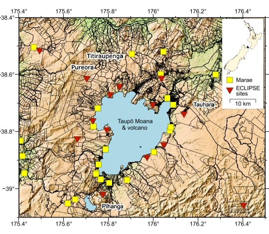
The yellow squares are Maori meeting houses (Marae). (Image: Figure 1, Mestel et al., 2025a, CC BY-ND-NC-SA 4.0)
With mutual communication lines open, and with goodwill on both sides, these Maori communities allowed the scientists to set up a temporary dense array of seismometers around the lake as part of the impressively named Eruption or Catastrophe: Learning to Implement Preparedness for future Supervolcano Eruptions (ECLIPSE) study from October 2019 to September 2022. (Mestel et al., 2025, 2025a)
Those seismic stations are the red triangles shown on the above map.
Mestel et al. (2025) report that the ECLIPSE study showed that only the seismicity under northern Lake Taupo is directly related to volcanism.
Other seismicity north of the lake and around and under southern Lake Taupo is controlled by Taupo Rift processes, i.e., tectonic.
This discovery can make it easier for volcanologists to identify magmatic signals that otherwise might be hidden by the background seismic noise of an active continental rift zone. (Mestel et al., 2025; Potter et al., 2015)
The team also identified a structure about four miles down that they suggest is related to Taupo’s unrest episodes. This is normal geology — the area where the Oruanui and Y caldera faults meet — not anything scary.
It’s actually a step forward in understanding Taupo’s internal structure and its processes!
🌋🌋🌋
Closing
How does one close such a long post about this very active and hazardous supervolcano that is also a leading-edge research topic?
With a song (here is translation of the Maori part):
🖋️🖋️🖋️
Mini writing update
There are three supervolcanoes to go, and these are all in the United States.
One (not Yellowstone) might be moribund.
One (not Yellowstone) really does host a secret lab that makes weapons of mass destruction and, among other things, indirectly was responsible for Gojira.
Next time: the “supervillain lair.”
Featured image: Alice Stone/Shutterstock
Sources:
- Acocella, V.; Di Lorenzo, R.; Newhall, C.; and Scandone, R. 2015. An overview of recent (1988 to 2014) caldera unrest: Knowledge and perspectives. Reviews of Geophysics, 53(3): 896-955.
- Allan, A. S.; Wilson, C. J.; Millet, M. A.; and Wysoczanski, R. J. 2012. The invisible hand: Tectonic triggering and modulation of a rhyolitic supereruption. Geology, 40(6): 563-566.
- Allan, A. S.; Morgan, D. J.; Wilson, C. J.; and Millet, M. A. 2013. From mush to eruption in centuries: assembly of the super-sized Oruanui magma body. Contributions to Mineralogy and Petrology, 166(1): 143-164.
- Allan, A. S.; Barker, S. J.; Millet, M. A.; Morgan, D. J.; and others. 2017). A cascade of magmatic events during the assembly and eruption of a super-sized magma body. Contributions to Mineralogy and Petrology, 172(7): 49.
- Bachmann, O., and Huber, C. 2016. Silicic magma reservoirs in the Earth’s crust. American Mineralogist, 101(11): 2377-2404.
- Ballance, P. F.; Ablaev, A. G.; Pushchin, I. K.; Pletnev, S. P.; and others. 1999. Morphology and history of the Kermadec trench–arc–backarc basin–remnant arc system at 30 to 32 S: Geophysical profile, microfossil and K–Ar data. Marine Geology, 159(1-4): 35-62. Abstract only.
- Barker, S. J.; Van Eaton, A. R.; Mastin, L. G.; Wilson, C. J.; and others. 2019). Modeling ash dispersal from future eruptions of Taupo supervolcano. Geochemistry, Geophysics, Geosystems, 20(7): 3375-3401.
- Barker, S. J.; Wilson, C. J.; Illsley-Kemp, F.: Leonard, G. S.; and others. 2021. Taupō: an overview of New Zealand’s youngest supervolcano. New Zealand Journal of Geology and Geophysics, 64(2-3): 320-346.
- Cashman, K. V., and Sparks, R. S. J. 2013. How volcanoes work: A 25-year perspective. Bulletin, 125(5-6): 664-690.
- Corella Santa Cruz, C. R. 2023). Subduction cycling and its controls on hyperactive volcanism in the Taupo Volcanic Zone, New Zealand: a thesis presented in partial fulfilment of the requirements for the degree of Doctor of Philosophy in Earth Science at Massey University, Palmerston North, New Zealand (Doctoral dissertation, Massey University).
- Crosweller, H. S.; Arora, B.; Brown, S. K.; Cottrell, E.; and others. 2012. Global database on large magnitude explosive volcanic eruptions (LaMEVE). Journal of Applied Volcanology, 1: 1-13.
s - Ellis, S.; Barker, S. J.; Wilson, C. J.; Hamling, I.; and others. (2023). Taupōinflate: illustrating detection limits of magmatic inflation below Lake Taupō. New Zealand Journal of Geology and Geophysics, 66(4): 571-588.
- GNS Science. 2025. Kermadec Arc and the Taupo Volcanic Zone. https://www.gns.cri.nz/our-science/land-and-marine-geoscience/earth-dynamics/kermadec-arc-and-taupo-volcanic-zone/ Last accessed December 17, 2025.
- GeoNet. 2025. About Taupo. https://www.geonet.org.nz/about/volcano/taupo Last accessed December 17, 2025.
- Gertisser, R., and Self, S. 2015. The great 1815 eruption of Tambora and future risks from large‐scale volcanism. Geology Today, 31(4): 132-136.
- Harmon, L. J.; Gualda, G. A.; Gravley, D. M.; Smithies, S. L.; and Deering, C. D. 2024. The Whakamaru magmatic system (Taupō Volcanic Zone, New Zealand), part 1: Evidence from tephra deposits for the eruption of multiple magma types through time. Journal of Volcanology and Geothermal Research, 445, 107966.
- Harmon, L. J.; Smithies, S. L.; Gualda, G. A.; and Gravley, D. M. 2024. The Whakamaru magmatic system (Taupō Volcanic Zone, New Zealand), part 2: Evidence from ignimbrite deposits for the pre-eruptive distribution of melt-dominated magma and magma mush. Journal of Volcanology and Geothermal Research, 447, 108013.
- Illsley‐Kemp, F.; Barker, S. J.; Wilson, C. J.; Chamberlain, C. J.; and others. 2021. Volcanic unrest at Taupō volcano in 2019: Causes, mechanisms and implications. Geochemistry, Geophysics, Geosystems, 22(6): e2021GC009803.
- Jellinek, A. M., and DePaolo, D. J. 2003. A model for the origin of large silicic magma chambers: precursors of caldera-forming eruptions. Bulletin of Volcanology, 65: 363-381.
- Klemetti E. 2011. Certainty vs Uncertainty: What “Supervolcano” Teaches Us About Science and Society. https://web.archive.org/web/20120305012105/https://www.wired.com/wiredscience/2011/04/certainty-vs-uncertainty-what-supervolcano-teaches-us-about-science-and-society/
- Lamb, O.; Bannister, S.; Ristau, J.; Miller, C.; and others. 2024. Seismic characteristics of the 2022-2023 unrest episode at Taupō volcano, Aotearoa New Zealand. Seismica, 3(2).
- Lowe, D. J., and Pittari, A. 2021. The Taupō eruption sequence of AD 232+-10 in Aotearoa New Zealand: a retrospection
- Mestel, E. R.; Illsley‐Kemp, F.; Savage, M. K.; Wilson, C. J.; and others. 2025. Seismicity from modern magmatic activity beneath Taupō volcano, Aotearoa New Zealand. Journal of Geophysical Research: Solid Earth, 130(9): e2025JB031644
- Mestel, E. R.; Smith, B.; Tapuke, K.; Illsley‐Kemp, F.; and others. 2025a. Mahi Tahi‐Rū Whenua: Tangata Whenua & Kairangahau Pūtaiao. Reflective learnings on partnering with Indigenous Māori communities in field‐based scientific research. Community Science, 4(2): e2023CSJ000066.
- Miller, C. F. and Wark, D. A. 2008. Supervolcanoes and their explosive supereruptions. Elements, 4(1): 11-15.
- Muirhead, J. D.; Illsley-Kemp, F.; Barker, S. J.; Villamor, P.; and others. 2022. Stretching, shaking, inflating: volcanic-tectonic interactions at a rifting silicic caldera. Frontiers in Earth Science, 10: 835841.
- New Mexico Bureau of Geology and Mineral Resources. Valles Caldera: New Mexico’s Supervolcano (PDF)
- Oppenheimer, C. 2011. Eruptions That Shook the World. Cambridge: Cambridge University Press. Retrieved from https://play.google.com/store/books/details?id=qW1UNwhuhnUC
- Poland, M. 2020. Caldera Chronicles: Caldera Systems — A World-Wide Family That Is More Than Just Yellowstone.
- Potter, S. H.,; Scott, B. J.; and Jolly, G. 2012. Caldera unrest management sourcebook. GNS Science, Wairakei Research Centre.
- Potter, S. H.; Scott, B. J.; Jolly, G. E.; Neall, V. E.; and Johnston, D. M. 2015. Introducing the Volcanic Unrest Index (VUI): a tool to quantify and communicate the intensity of volcanic unrest. Bulletin of Volcanology, 77(9): 77.
- Potter, S. H.; Scott, B. J.; Jolly, G. E.; Johnston, D. M.; and Neall, V. E. 2015. A catalogue of caldera unrest at Taupo Volcanic Centre, New Zealand, using the volcanic unrest index (VUI). Bulletin of Volcanology, 77(9); 78. (Abstract only)
- Pyle, D. M. 2018. What can we learn from records of past eruptions to better prepare for the future?. Observing the Volcano World: Volcano Crisis Communication, 445-462.
- Scott, E.; Bebbington, M.; Wilson, T.; Kennedy, B.; and Leonard, G. 2022. Development of a Bayesian event tree for short-term eruption onset forecasting at Taupō volcano. Journal of Volcanology and Geothermal Research, 432: 107687.
- Self, S. 2006. The effects and consequences of very large explosive volcanic eruptions. Philosophical Transactions of the Royal Society A: Mathematical, Physical and Engineering Sciences, 364(1845): 2073-2097.
- Trewick, S. A., and Bland, K. J. 2012. Fire and slice: palaeogeography for biogeography at New Zealand’s North Island/South Island juncture. Journal of the Royal Society of New Zealand, 42(3): 153-183.
- Wikipedia. 2026 Lake Taupo. https://en.wikipedia.org/wiki/Lake_Taup%C5%8D Last accessed January 14, 2026
- ___. 2025. New Zealand. https://en.wikipedia.org/wiki/New_Zealand . Last accessed December 18, 2025.
- ___. 2026. North Island. https://en.wikipedia.org/wiki/North_Island Last accessed January 14, 2026.
- ___. 2025. Taupo Volcano. https://en.wikipedia.org/wiki/Taup%C5%8D_Volcano Last accessed December 18, 2025.
- Wilson, C. J. N., and Walker, G. P. L. 1985. The Taupo eruption, New Zealand I. General aspects. Philosophical Transactions of the Royal Society of London. Series A, Mathematical and Physical Sciences, 314(1529): 199-228.
- Wilson, C. J.,; Blake, S.; Charlier, B. L. A.; and Sutton, A. N. 2006. The 26·5 ka Oruanui eruption, Taupo volcano, New Zealand: development, characteristics and evacuation of a large rhyolitic magma body. Journal of Petrology, 47(1): 35-69.
- Wilson, C. J.; Gravley, D. M.; Leonard, G. S.: and Rowland, J. V. 2009. Volcanism in the central Taupo Volcanic Zone, New Zealand: tempo, styles and controls. Studies in volcanology: the legacy of George Walker. Special Publications of IAVCEI, 2, 225-247.
- Wilson, C. J.; Cooper, G. F.; Chamberlain, K. J.; Barker, S. J.; and others. 2021. No single model for supersized eruptions and their magma bodies. Nature Reviews Earth & Environment, 2(9): 610-627.
