
Links to specific volcano updates:
___
Erta Ale
Hayli Gubbi
Fentale-Dofen
___
These are four African fire mountains that volcanologists closely watch right now, although there are other volcanoes in this particular section of northern Afar, Ethiopia, besides Erta Ale, Hayli Gubbi, Fentale, and Dofen.
Those are just the ones whose names you might have seen in the news this year — and Erta Ale also is famous in its own right for the lava lake(s):
The south pit lake has been around for at least ninety years. The north pit lake heats up into melt intermittently. (Moore et al.; Oppenheimer and Francis)
It’s a little difficult to describe just why these four volcanoes are in the news because the wonderful fact underlying this whole region complicates things a bit (for the scientists, not us): a mid-ocean ridge is forming here — on land, where experts can study it — as Africa breaks apart at the Afar triple junction.
Well, maybe we should call it a mid-sea ridge, since its northern end is already submerged under the Red Sea. (Acocella; Oppenheimer and Francis)
We aren’t going to need submersible subs to see our four troublemakers any time soon, though.
The tectonic processes behind their existence are happening over geologic time, and the ridge itself spreads slowly, compared to some others. (Moore et al.)
However, land around this subaerial proto-oceanic spreading ridge is already almost 700 feet below sea level! (Acocella)
The water just hasn’t gotten there yet. (Geomorphology is tricky: closer to home, the Willamette Valley, where I live, is a valley for the same tectonic reason — a subduction zone — that Puget Sound is a “valley,” but the sea hasn’t reached us.)
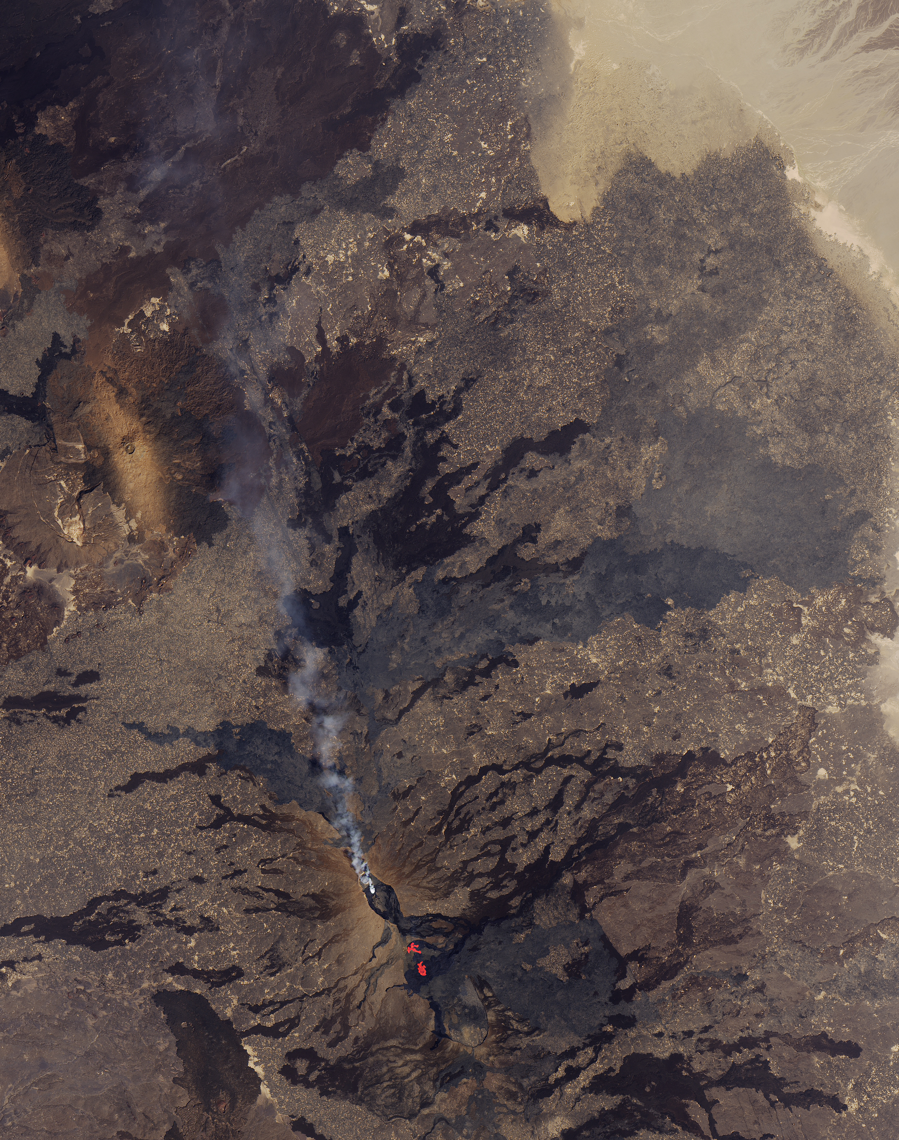
NASA Earth Observatory, public domain
While looking at the Erta Ale (red, smoking) and Fentale-Dofen region northeast of Erta Ale, note that a trip there is not as easy as a visit to, say, Iceland’s volcanoes (which are on the Reykjanes segment of the Mid-Atlantic Ocean Ridge); the arid terrain is rugged; and armed partisan groups are present and have attacked tourists at Erta Ale before, which is why you should have a military escort when you go.
All in all, the submersible sub will be safer, a million or so years from now, but then the working details of a spreading ridge will be much harder to experience directly.
Scientists do go there now and then, but it is easier for them to use data from satellites and/or GNSS (a GPS-like network) to study the area today, although this can mean a wait of days to weeks to see how things have changed in between each satellite pass. (La Rosa et al.; Lenhardt and Oppenheimer; Lewi et al.; Oppenheimer and Francis; Xu et al.)
Interest recently became acute among the boffins because activity has picked up in the area occupied by our four volcanoes.
Twice, that activity was intense enough for the news to reach us laypeople:
- At Fentale, in 2024, when a seismic swarm began:
- At Hayli Gubbi, on November 23, 2025, when this happened:
Although it didn’t make international headlines, something unusual also happened at Erta Ale this summer —
Unless we were there visiting at the time, we laypeople probably missed it.
And have any of us even heard of Dofen?
Confusing as all this is, it all ties together because of the “incipient mid-ocean ridge” thing but — precisely because of that fact — the details go WAY beyond the scope of a simple blog post meant to keep us updated on some interesting active volcanoes.
According to my very limited understanding, much of it may be due to what Icelandic scientists called a “rifting episode” — periods of magmatism that occur on mid-ocean ridges every few hundred years or so. (The ongoing cycle of eruptions on the Reykjanes Peninsula that began in Fagradalsfjall in 2021 are such a rifting episode, per Keir et al.; the last one there occurred about eight centuries ago.)
I think that the simplest thing to do is to put the references out there, per usual, at the post’s end for folks who are curious about the details and set up two sections below for basic links and updates on our four fire mountains.
This proto-ridge, as I understand the reading, is already in segments.
- Erta Ale and Hayli Gubbi are on the Erta Ale segment along with some other centers that apparently aren’t doing anything troublesome right now.
- Fentale and Dofen are in another segment. (Keir et al.; Lewi et al.; Way et al.)
The updates and general info are arranged by segment below, along with links to each volcano’s Wikipedia and Global Volcanism Program (GVP) pages for general and scientific background information, respectively.
Erta Ale Segment
Erta Ale
- GVP page
- Wikipedia page
- Toulouse VAAC
🌋🌋🌋
There isn’t anything unusual going on here at the time of writing.
🌋🌋🌋
Hayli Gubbi
- GVP page
- Wikipedia page
- Toulouse VAAC
🌋🌋🌋
At the time of Hayli Gubbi”s eruption, very little information about it was available as a summary. GVP quickly and thoroughly researched and wrote one:
An ash plume from the first recorded explosive eruption at Hayli Gubbi was detected in satellite data at around 1130 on 23 November. According to a news report, residents described hearing a loud sound and feeling a shock wave; an explosion was heard 50 km from Semera (190 km S of Hayli Gubbi). Ash plumes quickly rose to 13.7 km (45,000 ft) a.s.l., later reaching as high as 15.2 km (50,000 ft) a.s.l. At around 1400 satellite data showed that the plume was spreading into the upper troposphere and contained approximately 220,000 tons of sulfur dioxide. A sequence of satellite images showed the higher ash plume drifting ENE. The images also showed a lower altitude cloud of pyroclastic material moving to the N about 130 km and spreading about 60 km laterally. That plume appeared to be on or low to the ground, and followed terrain, suggesting that it was the dilute part of a pyroclastic density current. Photos included in news reports showed ash plumes rising from the flat ground at some distance from the crater, consistent with material rising from a PDC, although the exact location of the photos was unknown. News reports noted that many surrounding villages, including Afdera (28 km W), were covered in ashfall; no deaths were reported. Several flights were cancelled or diverted across various countries in the region. Although the Toulouse VAAC reported that eruptive activity ceased by 2300, a large ash plume with a significant sulfur dioxide component persisted over Yemen, with lower-level ash continuing to drift over Ethiopia.
The Toulouse VAAC stated that by 0057 on 24 November a substantial ash and sulfur dioxide cloud was present over Yemen and Oman, and by 1058 the plume was situated between Oman and Pakistan, moving ENE at altitudes of 7.6-13.7 km (25,000-45,000 ft) a.s.l. By 1700 a broad ash cloud was spreading E across southern Pakistan and northeastern India, with a possible plume of resuspended ash rising to 4.6 km (15,000 ft) a.s.l. detected near the Gulf of Aden. By 2300 the ash cloud was detected over northern Indian (over Delhi, 4,130 km NE) and was moving quickly towards China. News media reported flight disruptions in India on 25 November.
According to the UK Centre for Observation and Modelling of Earthquakes Volcanoes and Tectonics (COMET) response reports, explosive activity at Erta Ale (12 km NW) on 15 July was accompanied by an intrusion of magma along a dike that propagated SE towards Hayli Gubbi. Sentinel satellite imagery on 16 July showed a line of fissure vents that produced lava flows outside the S caldera of Erta Ale (6 km S of the northern pit craters). Another group of four fissure vents opened further along the rift to the SE, with the most distant only 2 km from the Hayli Gubbi crater. No lava lakes were seen in the pit craters after 18 July, but satellite data indicated uplift in the region during 21 July-3 August, and an anomalous white cloud within Hayli Gubbi’s crater was observed on 25 July. Satellite data showed that the white plume covered the crater floor in most of the images (several per month) at least through 18 November.
A few days after the eruption, Volcano Discovery visited the crater and found that white gas cloud again present:
🌋🌋🌋
Fentale-Dofen Segment
The Fentale-Dofen region is seismically and volcanically the most active part of the northern Main Ethiopian Rift. (Lewi et al.)
It lived up to that reputation most recently from late November 2024 through early 2025 with a seismic swarm that included more than three hundred temblors greater than or equal to M4 as well as ground deformation that damaged local infrastructure and moved a GNSS station in Addis Ababa, about 75 miles away.
There was no eruption, although fumaroles and other signs of restlessness occurred in Fentale caldera. (Lewi et al.; Way et al.)
Magma intrusions underground as dikes between Fentale and Dofen were probably the cause. (Lewi et al.; Way et al.)
According to most of my reading on this and on Iceland, dike formation is the most common event in rifting episodes.
Seventy-five thousand people were evacuated from the area around Fentale and Dofen, which includes agricultural land as well as the main road connection between Ethiopia and Djibouti, and a simple hazard map was made. (Lewi et al.)
Lewi et al. write that possible future activity might include any of the following:
- More underground intrusions and maybe some surface lava flows.
- An explosive eruption at Fentale.
- New diking south of Fentale when the stress between Fentale and Dofen (located to the north) is relieved.
I haven’t seen any more news, but if and when it comes, the updates will be below.
Fentale
- GVP page
- Wikipedia page
- Toulouse VAAC
🌋🌋🌋
From the GVP page:
Most Recent Weekly Report: 15 January-21 January 2025
Satellite data analysis by the MIROVA team indicated that thermal anomalies over Fentale crater were visible during 13-14 January and progressively increased in size at least through 0020 on 21 January (local time). No cause of these anomalies has been identified. A visible satellite image showed a possible gas plume over the crater. A 14 January news article stated that the Fentale crater typically hosts a small lake and that billowing plumes rise above the summit. The article also noted that 10,000 people evacuated from Seganto and possibly a total of 54,000 had been evacuated from higher-risk areas. The earthquakes damaged schools, buildings, a factory, and roads.
🌋🌋🌋
Dofen
- GVP page
- Wikipedia page
- Toulouse VAAC
🌋🌋🌋
From the GVP page:
Most Recent Weekly Report: 15 January-21 January 2025
Satellite data analysis by the MIROVA team indicated that thermal anomalies over Fentale crater were visible during 13-14 January and progressively increased in size at least through 0020 on 21 January (local time). No cause of these anomalies has been identified. A visible satellite image showed a possible gas plume over the crater. A 14 January news article stated that the Fentale crater typically hosts a small lake and that billowing plumes rise above the summit. The article also noted that 10,000 people evacuated from Seganto and possibly a total of 54,000 had been evacuated from higher-risk areas. The earthquakes damaged schools, buildings, a factory, and roads.
🌋🌋🌋
Featured image: Thomas Maluck, CC BY-ND 2.0.
Sources:
- Acocella, V. 2006 Regional and local tectonics at Erta Ale caldera, Afar (Ethiopia). Journal of Structural Geology, 28(10): 1808-1820.
- Albino, F.; Biggs, J.; Lazecký, M.; and Maghsoudi, Y. 2022. Routine processing and automatic detection of volcanic ground deformation using Sentinel-1 InSAR data: insights from African volcanoes. Remote Sensing, 14(22): 5703.
- Keir, D.; La Rosa, A.; Pagli, C.; Wang, H.; and others. 2025. The 2024 Fentale diking episode in a slow extending continental rift. Geophysical Research Letters, 52(5): e2024GL113214.
- La Rosa A.; Pagli C.; Keir D.; Ayele A.; and others. 2025 Segmented dike intrusion linked to multi-level magma storage during and before the 2025 eruption at Erta Ale (East Africa). Front. Earth Sci. 13:1719687.
- Lenhardt, N., and Oppenheimer, C. 2014. Volcanism in Africa: geological perspectives, hazards, and societal implications (Vol. 1, pp. 169-199). Cambridge, UK: Cambridge University Press.
- Lewi, E.; Biggs, J.; Ayele, A.; Wright, T.; and others. 2025. Scientific response to the 2024–2025 dyke intrusions in the Fentale-Dofen Region, Ethiopia: geophysical monitoring, surface manifestations, and hazard mapping. Bulletin of Volcanology, 87(8): 64.
- Moore, C.; Wright, T.; Hooper, A.; and Biggs, J. 2019. The 2017 Eruption of Erta’Ale Volcano, Ethiopia: Insights into the shallow axial plumbing system of an incipient Mid‐Ocean Ridge. Geochemistry, Geophysics, Geosystems, 20(12): 5727-5743.
- Oppenheimer, C., and Francis, P. 1998. Implications of longeval lava lakes for geomorphological and plutonic processes at Erta’Ale volcano, Afar. Journal of Volcanology and Geothermal Research, 80(1-2): 101-111.
- Way, L.; Biggs, J.; Zheng, W.,; Lazecky, M.; and others. 2025. Real-time satellite monitoring of the 2024–2025 dyke intrusion sequence at Fentale-Dofen volcanoes, Ethiopia. Bulletin of Volcanology, 87(11): 100.
- Xu, W.; Rivalta, E.; and Li, X. 2017. Magmatic architecture within a rift segment: Articulate axial magma storage at Erta Ale volcano, Ethiopia. Earth and Planetary Science Letters, 476, 79-86.
