

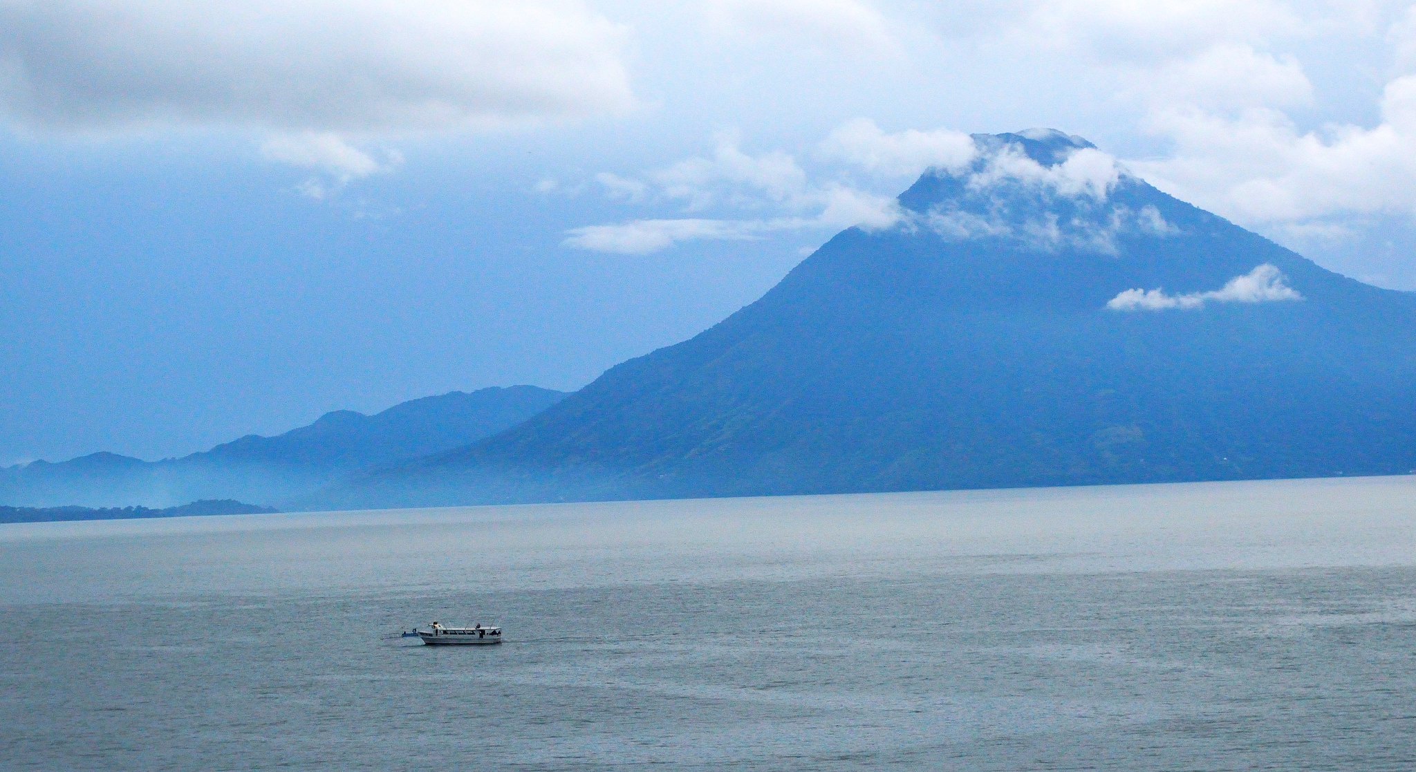
The hills are volcanic, but this one — San Pedro, the oldest volcano on Lake Atitlan — went quiet about 40,000 years ago. (Image: Christopher Lance, CC BY-NC-ND 2.0
Even when it’s a layperson blogging, some scientific rigor about volcanoes is occasionally necessary, and that is the point at which most readers run screaming for the hills.
But if you click away now, you’ll be missing a beautiful mystery.
The beauty, as we’ll soon see, is obvious — and magnificent.
The mystery is an intriguing “what if”: What if Toba’s hypothetical but potentially ruinous climate effects got an assist from a roughly simultaneous supereruption on the opposite side of the world?

Don’t sweat the graphs — just check out the locations. (Image: Figure 1, Cisneros de Leon et al. (2022), CC BY-SA-NC-ND 4.0)
Can that happen?
Let’s just get the nerd stuff out of the way up front and then literally dive into all that beauty and mystery.
Toliman might still be active but it hasn’t erupted in recorded history. (Image: Alberto Castillo, CC BY-NC-ND 2.0
YTT from Cisneros de Leon et al. (2022) and Innes et al.:
- 73.7 ± 0.3 ka
- 73.7 ± 0.6 ka
- 73.9 ± 0.3 ka
- 74.7 ± 1.8 ka
- 75.0 ± 0.9 ka
- 75.5 ± 4.7 ka
- 75.7 ± 4.1 ka
There. That wasn’t so bad, was it?
Something happened between roughly 73 and 75+ thousand years ago (ka).
Also, Innes et al. have recognized LCY bipolar tephra and they dated it to 79.5 ± 3.4 ka.
Done. No quiz. What the event was some 74,000 years ago — and it was a biggie — will become clear later in the post.
Now it’s time to go for a swim and meet LCY.
The Beauty
What is Lake Atitlan?

Volcán Atitlan is active; its last eruption was in the 1850s. (Image: Renata Avila, CC BY 2.0
Lake Atitlan is a relatively unspoiled travel destination in Guatemala’s spectacular volcanic highlands (which have risen into gorgeousness because of the complex tectonics happening here as the North American, Caribbean, and Cocos plates come together and the Cocos plate subducts under the leading edge of North America).
The 11 x 5-mile highland lake sits about thirty miles northwest of Antigua and about sixty miles north-northeastwest (NNW) of Fuego volcano.
In words, Lake Atitlan sounds like a place where tourists can spend a very pleasant week:
Besides the lake views, this video has a high calorie count!
Of note, while the narrator of that video is in the water, talking, see the light-colored rock behind her head?
Not a pop quiz, but it will be important in a few paragraphs to know that this sort of rock is called a tuff, or ignimbrite.
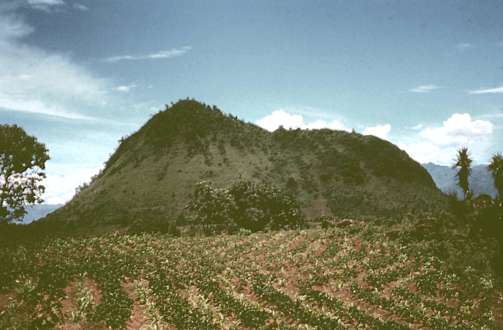
Lava flowed on Cerro de Oro within the last few thousand years. (Image: Bill Rose via GVP, CC BY-NC-ND 4.0
It’s what pyroclastic flows look like after they’ve settled, cooled, and hardened over many millennia. (Brown et al.)
Visually, Lake Atitlán is still a contender for the title bestowed upon it by 19th-century explorer Alexander Von Humboldt, who called it “the most beautiful lake in the world”:
Note the light-colored ground in that video, too, appearing at various places on the steep walls that tower over this, the deepest lake in Central America.
Atitlan’s average depth is a bit more than 500 feet, according to Dr. Wikipedia, and the lake bed goes down as much as 1,150 feet in some places.
Los Chocoyos (LCY)
All of the ground around Lake Atitlan, including what’s covered by vegetation or human buildings and infrastructure — and even the bedrock that starts some 2,000 feet below the lake’s surface — is ignimbrite.
As mentioned, this is a technical name, like “tuff,” for pyroclastic flow deposits.
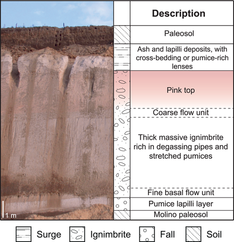
Seen here at an outcrop near Lake Atitlan. The image is Figure 2 in Cisneros de Leon et al. (2021), CC BY-SA-NC-ND 4.0.
This particular combination of ignimbrite (found up to 80 miles or more away from the vent, according to Cisneros de Leon et al., 2021) and ash (fallout from eruption plumes and the umbrella cloud), is called Los Chocoyos (LCY) and it is very famous among geoscientists.
The whitish material stands out nicely and so is a useful stratigraphic marker for geological deposits on land and in the sea.
Los Chocoyos ash has been found from Florida and the Gulf of Mexico to the eastern Pacific as far south as offshore Ecuador: an area of almost 4 million square miles. (Brenna et al.)
Yes, it came from a supereruption.
Recent estimates of volume show that at least 710 km3 of magma (Wilson et al.) blew out of the ground in what is now western Guatemala on what must have been a very bad day or days for regional wildlife and plants — as far as anyone knows, no humans had yet migrated into North, Central, and South America.
Both North and South America have supervolcanoes, but Los Chocoyos is the first recognized supereruption in Central America. It’s also the biggest known eruption in the Americas over the last 100,000 years. (Cisneros de Leon et al., 2022)
Which of those scenic volcanoes had the supereruption?
None of them did, although the stratovolcanoes along Lake Atitlan’s southern margin are very tall and powerful looking.
San Pedro, Toliman, and Atitlan (the volcano) aren’t restless right now, but they are all fairly young in geologic terms — less than 100,000 years old (for comparison, YTT, a/k/a the Youngest Toba Tuff, supererupted on northern Sumatra about 74,000 years ago).
According to Chris Newhall, one of the volcano experts who studied this area thoroughly in the 1980s, San Pedro arose first.
It was followed by Toliman, whose sticky lava flows built the lava dome Cerro de Oro (named for a legendary buried treasure) on Toliman’s north flank.
San Pedro quieted down some forty millennia ago but Toliman might still be active because a lava flow that’s just a few thousand years old extends out under the lake from Cerro de Oro. (Newhall; Wikipedia)
The youngest stratovolcano — also named Atitlan — definitely is still with us.
It erupted in the 1400s and again in 1853. Its cone currently is covered with pyroclastic material, but Volcán Atitlan can erupt either explosively or with lava flows. (GVP; Newhall)
So where’s the supervolcano?
Part of it is directly underneath Volcán Atitlan, whose summit rises over the southern rim of an 11 x 8-mile-wide caldera that formed when the Los Chocoyos supereruption emptied out its magma reservoir. (GVP)
The deepest lake in Central America, one of the most beautiful lakes in the world, now fills most of this caldera, which volcanologists call Atitlan III.
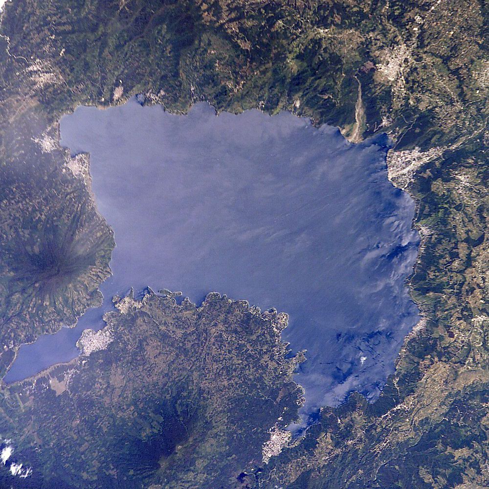
NASA, via Wikimedia, public domain.
The Supereruption
Atitlan I, II, and III
Newhall found evidence of three caldera cycles here over the last 14 million years (which he notes is an unusually long time for a group of related calderas to be active in one spot).
Each cycle seems to have started with “ordinary” volcanism that built stratovolcanoes like those we see today. Over time a vast quantity of explosive magma also brewed up, and eventually it all came out in one or more ignimbrite eruptions.
Then another cycle began.
Atitlan I caldera, which is located just north of today’s Lake Atitlan basin, had at least five ignimbrite eruptions, but with this one we’re talking about things that occurred way back in the Miocene epoch.
After more than ten million years in a tropical, tectonically active region, precise data retrieval can’t be expected from those deposits.
It probably isn’t possible to determine whether any or all of the Atitlan I ash-flow eruptions were supersized, but Newhall does mention that Atitlan I ash covers much of the highlands. It also has filled in some valleys.
And what still remains of the Atitlan I caldera measures 9 x 16 miles across, larger even than lake-filled Atitlan III.
So there’s that.
Cycle I lasted from around 14 to 11 million years ago.
Atitlan II followed it closely, but that Miocene caldera, with its possible center located a little south of Atitlan I and its more or less circular rim perhaps now overlapping calderas I and III, isn’t easy to trace.
Newhall describes at least one stratovolcano associated with Atitlan II, as well as at least one ignimbrite eruption occurring during that cycle, which ran from roughly 10 to 8 million years ago.
After it was over, seven million years went by.
The Miocene ended. The Pliocene came along, and about halfway through, saw the final land connections established between North and South America via the Isthmus of Panama.
Told you the tectonics here are complicated! 🙂 Take-away point: Dogs and cats migrated into South America from the north.
The world chilled down into ice ages, and eventually the Pliocene ended, though not the ice ages.
As Newhall points out, Atitlan has had a long and not always active history!
Then, about a million years ago, during the early Pleistocene, a set of stratovolcanoes formed in the general area of today’s lake basin, which is just south of Atitlan I caldera.
Atitlan III was underway!
This caldera is so recent that many of its details are still well preserved in the geologic record.
Nevertheless, what happened in that cycle before the supereruption is less well understood. (Cisneros de Leon et al., 2025)
Certainly there isn’t much left of those early Pleistocene fire mountains now.
Perhaps they foundered or blew up in the LCY blast, which actually wasn’t the only eruption that happened here.
It was just the biggest.
Cisneros de Leon et al. (2021, 2025) note that a whole series of large ignimbrite eruptions got going in this area, starting about half a million years ago.
Researchers are still working on it, but apparently none of those was supersized except the Los Chocoyos cataclysm.
At some supervolcanoes, including Yellowstone (but not Toba), smaller eruptions do come both before and after a supereruption.
At Atitlan, these lesser events were explosive ignimbrite blasts, not the sort of lava-flow eruptions that help to build stratovolcanoes.
However, that more mellow kind of volcanism returned in the late Pleistocene, when San Pedro, Toliman, and Volcán Aititlan appeared.
Because they follow the historical trend of new activity being juuuust a little south of the older site of operations, Newhall speculated that these three volcanic youngsters might be an indication that an Atitlan IV cycle has begun!
If so, and going by past cycles, this layperson expects that tens to hundreds of millennia will pass before another caldera eruption happens here.
Yay! But why are these cycles happening?
That question quickly gets us into PhD territory, even without considering the very relevant but complex regional tectonics.
On a simpler level the cycles remind me of something Bachmann and Huber, among others, have suggested to explain how gigantic volumes of magma can form in relatively cold shallow crust.
This is one of several unanswered questions that volcanologists have about supereruptions.
Basically, as I understand Bachmann and Huber, a period of “ordinary” volcanism occurs first, warming up that crust to the point where it doesn’t break apart any more for “ordinary” eruptions.
Instead, the warm crustal rock just sort of flows along, making room for more and more magma as the reservoir grows.
While this goes on for tens of thousands to hundreds of thousands of years, according to all of my reading, the magma is not just sitting there inert.
That hot melt constantly is absorbing some of the crustal rock; it’s forming crystals that accumulate on the walls and roof of the chamber (note: there is a popular “crystal-mush” model, too, but let’s save that for the Long Valley or Yellowstone post); parts of the long-lived magma are cooling down and degassing a bit; various other components are transitioning among gas, solid, and/or liquid phases…Bubble, bubble, toil and trouble — Earth’s “blood” is complex and lively stuff!
The ongoing processes over time change our supersizing magma’s chemistry into a stickier, more explosive mixture.
Its volume continues to increase until eventually something sets it off (what triggers supereruptions is another unanswered question).
Ignimbrite eruptions start and, occasionally, a supereruption.
The underlying cause for volcanism hasn’t changed — at supervolcanoes, including Atitlan, this is usually subduction, but hot spots and rifting also can do it — and so another cycle might start after these blasts have used up all the old magma.
That is way oversimplified, of course, and anyway, Bachmann and Huber are writing about supereruptions in general.
There is still much to learn about the specifics of Atitlan supervolcano and its history.
What was the LCY supereruption like?
As we’ll see in the “Mystery” section, assigning a date to Atitlan III’s Los Chocoyos supereruption is problematical, but there seems to be overall agreement about how it generally went down.
Presumably the highland countryside back then looked much the same as it does today, although no one can say for sure whether Atitlan II caldera contained a lake.
There definitely was a lot of water in the area somewhere, though, given how the Atitlan III eruption sequence ended!
The early Pleistocene stratovolcanoes were present. For convenience (but not accuracy), let’s assume that there were three of them, just like the newer San Pedro, Toliman, and Atitlan Volcano.
During the Atitlan III cycle there had been big (but not super) eruptions in this area before.
When a powerful blast came one day and sent a thick eruption plume more than 25 miles up into the sky (Newhall), if any humans had been around (which there weren’t, fortunately), they would have assumed that this was going to be more of the same.
But the ash kept coming. It formed an umbrella cloud broad enough to drop material across most of the Gulf of Mexico and adjacent coasts of what are now Texas and Florida.
Then came the pyroclastic flows: big ones. They surged over highland ridges and filled in valleys as far as 80 miles or more from the vents.
About those vents — Cisneros de Leon et al. (2021) suggest that the fiery death clouds came out as the Atitlan III caldera collapsed.
This is what probably happened during the Youngest Toba Tuff (YTT) eruption in Indonesia, on the other side of the world, some 74,000 years ago.
However, Newhall mentions evidence that the fiery death clouds might have come before the Atitlan III caldera formed.
He suggests that caldera collapse possibly occurred at least a few weeks after the Los Chocoyos climax.
This is one of those uncertain details that scientists will be trying to collect data on during the next supereruption, while the rest of us are running around in a panic or hiding in a bunker somewhere.
Newhall doesn’t say much more about Atitlan’s great pyroclastic flows, other than that Los Chocoyos ash found in the eastern Pacific off the coasts of Central and South America probably comes, at least in part, from the vast coignimbrite clouds that rose above those glowing density currents.
After all, even “ordinary” pyroclastic flows don’t stop at water’s edge; they keep moving as long as Gravity remains in the driver’s seat.
This brings up the possibility of tsunamis, generated as the Atitlan III pyroclastic currents hit the sea, but I haven’t come across any discussion of that in my very limited reading on Los Chocoyos.
Finally, a few weeks to years after the big paroxysm, water and magma somehow came into contact. Enormous phreatomagmatic eruptions laid down what Newhall calls “spectacular surge deposits” that now extend almost 10 miles northeast and northwest of the Atitlan III caldera.
Sort of like this; although this is a different kind of volcanism, it’s coming through a lake in phreatomagmatic blasts. Now supersize it.
Did those happen as Lake Atitlan started to form in this tropical climate? Was there some other body of water present that somehow survived the catastrophic blast but then drained into the newly formed caldera?
Who knows?
Things did quiet down after that. Thousands of years later at least one lesser ignimbrite eruption occurred, like those that had come before the supereruption (Cisneros de Leon et al., 2025), and the three modern volcanoes arose just south of Lake Atitlan, whose margins still host a few hot springs to commemorate the violent past.
Possible Los Chocoyos climate effects
The region must have been devastated, of course, but what did this supereruption do to Earth?
More practically, what would we experience if another Los Chocoyos-sized eruption happened at Lake Atitlan (which is extremely unlikely on the human time scale)?
This is where things get very theoretical, since global climate effects from ancient volcanism don’t leave any direct evidence. (Brenna et al.; Oppenheimer)
Too, according to many sources, very little is known about supereruptions because scientists have never observed one.
Nevertheless, as with Toba, computer models of Atitlan’s supereruption have been run, using data gleaned from ash analysis and the most reasonable-sounding assumptions about things like plume height, season, and the climate-system state (which is where some major uncertainties wriggle into any model, per Bachmann and Huber, among other sources).
For Atitlan III, the petrological data show that Los Chocoyos magma had a very high sulfur content PLUS large quantities of a group of chemicals called halogens (for LCY, mainly chlorine and bromine).
Why not? Earth has the whole periodic table to play around with down there — as well as probably some elements that we haven’t discovered yet — and the recipe for every batch of magma is always different, everywhere in the world.
Despite the whitish color of its deposits, Los Chocoyos magma apparently was rather nasty.
Brenna et al. did a model study based on values of 523 ± 94 megatonnes of sulfur, 1200 ± 156 megatonnes of chlorine, and 2 ± 46 megatonnes of bromine (there’s that scientific rigor again).
They assumed for part of the study that not more than 10% of the halogens made it to the stratosphere. For the other part, they ignored the halogens completely.
They did that because, most of the time — including 1991’s Pinatubo and 2022’s Hunga Tonga-Hunga Ha’apai eruptons — halogens react wth water vapor in air and quickly get “scrubbed out” of the rising plume. (Oppenheimer)
Sulfur isn’t affected this way and therefore can reach the stratosphere in a plinian-style plume, where chemical reactions will turn it into the sort of climate-changing sulfate aerosol that we saw last time.

This. (Image: NASA, public domain; description from Oppenheimer)
Even with small amounts of halogens on board, Brenna et al.’s model run was a doozy.
Halogens, you see, besides being poisonous, are bad stuff to send into the stratosphere because they deplete ozone.
In the researchers’ model, Earth’s ozone layer almost completely collapsed after the LCY supereruption.
Just 20% of it was left and the model showed that surface ultraviolet levels increased 550% over the first five years!
It took fifteen years for the ozone layer to recover, and for eight of those years, ozone levels were still lower than those in the present-day hole over Antarctica.
Why are we not talking about the inevitable effects on life that this ozone catastrophe would have caused?
(Spoiler: Have we been talking about it under another name?)
Brenna et al. also found that, because of all that sulfur, a thick aerosol layer formed after Los Chocoyos — even in the runs that included halogens.
These runs showed global cooling from the sulfate aerosol, particularly in the Northern Hemisphere, for 30 years, as well as both drought for more than 10 years and rain in unusual places, like northern Africa, where the Sahara Desert greened up in the model, just as it does now and then in real life.
With such high modeled levels of incoming UV radiation, though, would all that moisture matter to North African life?
In this halogen part of the study, too, the sky darkened to an optical depth greater than 6 after the LCY supereruption.
As we saw in the Toba post, an optical depth of just 1-2 results in very polluted or dusty-appearing daylight, with the Sun almost totally hidden and extremely poor visibility.
A value of more than 6 might get visibility down to “bright moonlight” levels.
Hmmm.
These findings sound familiar.
They resemble effects suggested for the massive (5,300 km3 of magma) Youngest Toba Tuff eruption roughly 74,000 years ago.
The Mystery
The question of a link between Toba, in Indonesia, and Atitlan, in Guatemala, seldom came up before 2021.
No clues that might have made scientists curious, like the human genetic bottleneck that was, at one time, linked to the YTT (Youngest Toba Tuff) supereruption, ever pointed toward Atitlan and the LCY.
Toba, as the supervolcano that produced the world’s biggest eruption in the past 2 million years, is also very famous.
Smaller Atitlan, whose Los Chocoyos blast was only recently reclassified as a supereruption, is much less well known.
Not that any geoscientists ignored the gigantic Guatemalan caldera, of course.
Newhall, and others before and after him, studied it.
In 1980, someone did isotope profiles on that light-colored LCY ash in two widely separated deep sea cores and estimated its age at 84 ± 5 ka (thousand years) — not even in the same ballpark, so to speak, as Toba’s estimated 74,000-year-old YTT. (Brenna et al.; innes et al.; Lin et al.; Newhall)
However, a variety of ways to date volcanic ash have developed since then, and older methods have been improved.
In 2021, using zircon dating, Cisneros de Leon et al. reported a date for Los Chocoyos of 75 ± 2 ka.
That puts it within the error bars of Toba’s time frame.
Here’s what I mean.
Regarding Toba’s last supereruption, and bringing back some scientific rigor for a moment, different researchers trying to get precise dates for the YTT have come up with slightly different ones, including those we saw at the start of this post (I use “ka” to mean “thousand years ago”) —
From Cisneros de Leon et al. (2022) and Innes et al.:
- 73.7 ± 0.3 ka
- 73.7 ± 0.6 ka
- 73.9 ± 0.3 ka
- 74.7 ± 1.8 ka
- 75.0 ± 0.9 ka
- 75.5 ± 4.7 ka
- 75.7 ± 4.1 ka
I don’t know whether it’s a valid technique, but if you do the math, that list shows an overall date range for the Youngest Toba Tuff, in all these studies combined, from as recently as 73,100 years ago to as old as 80,200 years ago.
The new date of 73,000 to 77,000 years ago (75 ± 2 ka) for Los Chocoyos, published in 2021, is in that time range, too, and this caused quite a sensation!
Scientists quite rightly mistrust sensational findings, which get people excited, are often misunderstood by us laypeople, and can even send logic and objectivity flying out the academic window.
From the little reading that I’ve done, it appears that almost everyone has since been trying to disprove those findings of Cisneros de Leon et al. (2021).
But no matter how many resounding “NO!”‘s have been made to the possibility of a time connection between the YTT and LCY supereruptions, as far as I can tell it’s still an open question today.
The ongoing debate is very technical, but it all comes down to dates, out to a couple decimal places, for both the Youngest Toba Tuff (YTT) and Los Chocoyos (LCY).
Hard data from the planet’s polar regions could solve it.
Ice-core evidence
Sometimes volcanic sulfates and/or ash get caught in upper-level winds and fall out onto Greenland or Antarctica, where the material becomes part of the ice cap.
Volcanologists study polar ice cores and sometimes can identify which volcano a layer came from.
There’s a Pinatubo layer, for example.
The best proof is a chemical match on ash fragments, but these heavier particles don’t always make it to the poles.
Fortunately, the sulfate layers themselves in ice cores are fairly well dated and often can be correlated with modern eruptions.
The distant past is much more iffy.
There are at least four sulfate layers at both poles that span the Toba time period. (Lin et al.)
Which one is Toba’s?
So many variables are involved in getting sulfur from a volcano to polar ice that it isn’t sufficient to simply assume that the biggest sulfate layer came from the biggest known eruption during that period. (Oppenheimer)
No Toba ash (which would settle the question of layer identification) has yet been found at either pole, surprisingly, but Innes et al. recently recognized a few fragments of Los Chocoyos ash in both Arctic and Antarctic ice cores.
A date for Los Chocoyos!
Innes et al. identified glass shards that appear to chemically match samples from the Los Chocoyos eruption deposits.
While the researchers call for more chemistry correlation of their findings, they date the Atitlan III supereruption to somewhere between 82,900 to 76,100 years ago (79.5 ± 3.4 ka).
To sum up all these numbers:
- Toba YTT, date range found in several studies): 73,100 years ago to 80,200 years ago
- Atitlan LCY, Cisneros de Leon et al. (2021): 73,000 to 77,000 years ago
- Atitlan LCY, Innes et al.: 76,100 to 82,900 years ago
Don’t get all caught up in those numbers, though. Science is so precise that it denies claims of precision until everything lines up and can be replicated by someone else.
This happens rarely and only after lengthy work and much trial and error.
Which is probably why Innes et al. themselves declare that, according to the date they prefer for Toba, the two supereruptions were separated by some five thousand years — too long a time, they note, for climate effects from each cataclysm to interact.
Every source I’ve read agrees that modeled climate effects of a supereruption last, at most, a few decades.
This would be awful for affected life but negligible in terms of geologic time.
On that same Earth calendar, though, five thousand years is an unusually short interval between supereruptions.
Why does it matter?
It matters because multiple sources note that there is a very small but very real possibility that humanity might need to deal with a supereruption, somewhere in the world, in the (hopefully) distant future.
And we will want to cancel the apocalypse then, or at least to mitigate it
No running around in a panic. No hiding in bunkers.
What will we do?
Well, it depends on what geoscientists can learn ahead of time from evidence left behind by past supereruptions.
This includes answering such questions as the likelihood of potential ozone catastrophes; optical depth increases; precursors, triggering, and duration of the supereruption; duration and location of potential climate effects (models by Black et al. for Toba and Brenna et al. for Los Chocoyos suggest that the worst effects occur in the Northern Hemisphere for both of these tropical eruptions); and so forth.
As well…
A new question
The possible (but not proven) time connection between the Toba and Atitlan supereruptions raises an unexpected new question because of their location relative to each other.
First, the timing.
How often do superuptions happen?
At most, only a few thousand years separate the Youngest Toba Tuff and Los Chocoyos eruptions. (Innes et al.)
That’s very unusual.
Uncertainties abound when working out how often supereruptions happen, according to multiple sources.
Reasons for that include the geologic record being hard to interpret and also the rarity of supereruptions (statistics are more reliable when there are lots of data sets; extreme value theory is also involved but not really needed for this post).
Nonetheless, commonly cited global mean frequencies of supereruptions range from 1 or 2 per million years (Mason et al.) to 1 every 100,000 to 200,000 years (Self).
Cisneros de Leon et al. (2022) crunched numbers and found that, while it’s not impossible for two supereruptions to occur in a much shorter period of time than that, it’s not very likely.
For them, location is what counts.
Antipodal supereruptions
Relax. In plain English, that just means “supereruptions at opposite points on the Earth.”
Again. (Image: Figure 1, Cisneros de Leon et al. (2022), CC BY-SA-NC-ND 4.0)
And that’s the unexpected — and thus far, unanswerable — question: can that happen?
Cisneros de Leon et al. (2022) cite astronomical examples of seismic waves having apparently traveled through a planet, causing geological effects on the opposite point.
This “antipodal effect” has indeed been suggested for sites on Mars and Mercury.
I don’t know what current astronomy research has to say about that, but I can’t follow Cisneros de Leon et al. (2022) on this because Mars and Mercury don’t have Earth-style plate tectonics, with all its mantle convection currents, descending slabs, phase transitions, and other clutter (not to mention all the complexities closer to and on the planetary surface where plates move around).
Certainly seismic waves travel through Earth — using them for tomography, like a CT scanner, lets us see some deep Earth structure:
— but can these waves be focused enough to have an antipodal effect on Earth?
And if so, what is their connection to supereruptions?
No, I prefer just the mystery, which can also be put this way: two superuptions occurring close in time could be a coincidence; two supereruptions on opposite sides of the planet could be a coincidence; but it’s difficult to believe that two superuptions could coincidentally occur close in time AND at opposite ends of the planet.
Now there’s a mystery to contemplate if you get bored while splashing around in Lake Atitlan —
— or flying a drone over Lake Toba and its Samosir Island resurgent dome (a typical feature of big calderas but one that’s absent at Atitlan) —
— and it’s one question that none of us laypeople need to answer, though it’s good to know that some of the best minds we’ve got are working on it and on other questions in preparation for the day — hopefully, many centuries from now — when the supereruption apocalypse finally comes knocking at our door.
Featured image: Ricardo Barata/Shutterstock
Sources:
- Bachmann, O., and Huber, C. 2016. Silicic magma reservoirs in the Earth’s crust. American Mineralogist, 101(11): 2377-2404.
- Baudry, A.; Singer, B. S.; Jicha, B.; Jilly-Rehak, C. E.; and others. 2024. A Bayesian age from dispersed plagioclase and zircon dates in the Los Chocoyos ash, Central America. Earth and Planetary Science Letters, 643: 118826.
- Brenna, H.; Kutterolf, S.; Mills, M. J.; and Krüger, K. 2020. The potential impacts of a sulfur-and halogen-rich supereruption such as Los Chocoyos on the atmosphere and climate. Atmospheric Chemistry and Physics, 20(11): 6521-6539.
- Brown, S. K.; Crosweller, H. S.; Sparks, R. S. J.; Cottrell, E.; and others. 2014. Characterisation of the Quaternary eruption record: analysis of the Large Magnitude Explosive Volcanic Eruptions (LaMEVE) database. Journal of Applied Volcanology, 3: 1-22.
- Caricchi, L.; Annen, C.; Blundy, J.; Simpson, G.; and Pinel, V. 2014. Frequency and magnitude of volcanic eruptions controlled by magma injection and buoyancy. Nature Geoscience, 7(2): 126-130.
- Cashman, K. V., and Sparks, R. S. J. 2013. How volcanoes work: A 25-year perspective. Bulletin, 125(5-6): 664-690.
- Cisneros de León, A.; Schindlbeck‐Belo, J. C.; Kutterolf, S.; Danišík, M.; and others. 2021. A history of violence: magma incubation, timing and tephra distribution of the Los Chocoyos supereruption (Atitlán Caldera, Guatemala). Journal of Quaternary Science, 36(2): 169-179.
- Cisneros de León, A.; Mittal, T.; de Silva, S. L.; Self, S.; and others. 2022. On synchronous supereruptions. Frontiers in Earth Science, 10: 827252.
- Cisneros de León, A.; Danišík, M.; Schmitt, A. K.; Schindlbeck‐Belo, J. C.; and othersKutterolf. 2025. Refining the eruption chronology of Atitlán caldera through zircon double‐dating. Geochemistry, Geophysics, Geosystems, 26(3): e2024GC011953.
- Garnier, B.; Tikoff, B.; Flores, O.; Jicha, B.; and others. 2022. Deformation in Western Guatemala Associated With the NAFCA (North America‐Central American Forearc‐Caribbean) Triple Junction: Neotectonic Strain Localization Into the Guatemala City Graben. Tectonics, 41(2): e2021TC006739.
- Gelman, S. E.; Gutiérrez, F. J.; and Bachmann, O. 2013. On the longevity of large upper crustal silicic magma reservoirs. Geology, 41(7): 759-762.
- Giordano, G., and Caricchi, L. 2022. Determining the state of activity of transcrustal magmatic systems and their volcanoes. Annual Review of Earth and Planetary Sciences, 50(1): 231-259.
- Global Volcanism Program. 2025. Atitlan. https://volcano.si.edu/volcano.cfm?vn=342060
- Innes, H. M.; Hutchison, W.; Sigl, M.; Crick, L.; and others. 2025. Ice core evidence for the Los Chocoyos supereruption disputes millennial-scale climate impact. Communications Earth & Environment, 6(1): 137.
- Mason, B. G.; Pyle, D. M.; and Oppenheimer, C. 2004. The size and frequency of the largest explosive eruptions on Earth. Bulletin of Volcanology, 66(8): 735-748.
- McGraw, Z.; DallaSanta, K.; Polvani, L. M.; Tsigaridis, K.; and others. 2024. Severe global cooling after volcanic super-eruptions? The answer hinges on unknown aerosol size. Journal of Climate, 37(4): 1449-1464.
- Miller, C. F. and Wark, D. A. 2008. Supervolcanoes and their explosive supereruptions. Elements, 4(1): 11-15.
- Newhall, C. G. 1987. Geology of the Lake Atitlan region, western Guatemala. Journal of Volcanology and Geothermal research, 33(1-3): 23-55.
- New Mexico Bureau of Geology and Mineral Resources (NMBGMR). Valles Caldera: New Mexico’s Supervolcano (PDF)
- Oppenheimer, C. 2011. Eruptions That Shook the World. Cambridge: Cambridge University Press. Retrieved from https://play.google.com/store/books/details?id=qW1UNwhuhnUC
- Paine, A. R., and Wadsworth, F. B. 2025. Large explosive eruptions may be dominated by pyroclastic flows instead of buoyant plumes: insights from a global data compilation. Journal of Applied Volcanology, 14(1): 3.
- Self, S. 2006. The effects and consequences of very large explosive volcanic eruptions. Philosophical Transactions of the Royal Society A: Mathematical, Physical and Engineering Sciences, 364(1845): 2073-2097.
- Sigl, M.; Winstrup, M.; McConnell, J. R.; Welten, K. C.; and others. 2015. Timing and climate forcing of volcanic eruptions for the past 2,500 years. Nature, 523(7562): 543-549.
- Sulpizio, R.; Dellino, P.; Doronzo, D. M.; and Sarocchi, D. 2014. Pyroclastic density currents: state of the art and perspectives. Journal of Volcanology and Geothermal Research, 283: 36-65.
- Wikipedia. 2025. Lake Aititlan. https://en.m.wikipedia.org/wiki/Lake_Atitl%C3%A1n# Last accessed June 5, 2025.
- Wilson, C. J.; Cooper, G. F.; Chamberlain, K. J.; Barker, S. J.; and others. 2021. No single model for supersized eruptions and their magma bodies. Nature Reviews Earth & Environment, 2(9): 610-627.
- Zhuo, Z.; Fuglestvedt, H. F.; Toohey, M.; Krüger, K. 2024. Initial atmospheric conditions control transport of volcanic volatiles, forcing and impacts. Atmospheric Chemistry and Physics, 24(10): 6233-6249.
