
This is the longest interval yet between eruptions on the Reykjanes Peninsula. The series began in December 2023, and the most recent eruption was in November-December 2024. (All related blog posts can be found in the Iceland category.)
Here is the Icelandic Met Office’s current update, as of March 4th, via Google Translate, plus assorted links:
Increased chance of magma flow and even volcanic eruption
4.3.2025Updated March 4 at 3:10 PM
Landris continues at a similar pace
Low pressure in recent days has potentially limited the sensitivity of the monitoring network in the area, but little seismic activity has been recorded in recent days.
It must be assumed that a volcanic eruption can begin at very short notice.
The magma is most likely to first erupt in the area between Sundhnúkur and Stóra-Skógfell.
The area affected by a volcanic eruption is governed by whether volcanic fissures extend north or south.
The risk assessment remains unchanged and is valid until March 11th.
Deformation measurements show that land uplift is continuing at a similar rate to the past few weeks. The amount of magma under Svartsengi is now greater than what was estimated before the eruption that began on November 20.
There is still an increased likelihood of a magma flow and eruption, and everything indicates that it could occur within the next few days or weeks.
…
Eruptions must be expected at short notice.
Based on previous events at the Sundhnúk crater series, it can therefore be assumed that there is an increasing probability that the next event will begin within a few days or weeks. It is believed that magma would most likely first emerge in the area between Sundhnúk and Stóra-Skógfell. This has been the case in six of the seven eruptions that have occurred since the volcanic activity began in late 2023. The exception is the eruption that began in January 2024 when magma first emerged just south of Hagafell.
The impact of a volcanic eruption that begins between Sundhnúkur and Stóra-Skógfell depends on whether the eruption fissure extends north or south.
Seismic activity around Sundhnúk has decreased slightly in recent days compared to the past few weeks. However, bad weather in recent days may have affected the measuring system and limited sensitivity to the smallest earthquakes. Due to repeated events in the Sundhnúk crater series where magma tunnels and volcanic fissures have formed, the tension in the earth’s crust has decreased with each event. This means that fewer and smaller earthquakes are measured in the area in the weeks and days before an eruption than they did in the run-up to the first eruptions.
Very short notice is required for an eruption, but in the last two eruptions, it took just 30–40 minutes from the first signs of the earthquake swarm to the eruption itself. The signs that have been seen as magma seeks the surface include intense small earthquake swarms in the Sundhnúk crater series, pressure changes in HS Orka’s wells in Svartsengi, deformation of fiber optic cables, and surface deformation seen in real-time GPS measurements…
- A 360° drone view of the Sundhnuks, Grindavik, and Svartsengi area on August 7, 2024, with labels.
- Icelandic Met Office (autotranslated).
- IMO geoscientist notes, (autotranslated).
- A 360° view of the power plant/Blue Lagoon area, taken at noon on November 23, 2024.
- Recent earthquakes (vafri.is)
- IMO earthquake page (Icelandic)
- London VAAC
- Catalogue of Icelandic Volcanoes
- University of Iceland Southern Volcanoes Facebook page
- New paper about what might be going on underground.
- RUV topic page and live coverage of the power plant crisis (autotranslated, but it doesn’t carry over into links).
- MBL.is topic page (autotranslated).
- Visir.is front page (autotranslated)
- RUV article (autotranslated) on volcanic hazard to Reykjavik.
- Jón Frimann’s blog.
- My archived posts on Iceland.
Links
Updates
March 16, 2:20 p.m., Pacific: Magnus Tumi on the eruption. (Icelandic)
He isn’t saying much new, except that the scope of the next eruption is likely to be similar in size to previous ones.
What he is doing, though, is keeping public attention focused on a very serious volcanic threat. Such crises are drawn out and public weariness/inattentiveness is a challenge that volcanologists mention again and again in their papers.
March 13, 2025, 7:23 p.m., Pacific: Per Benedikt at IMO:
“The seismic activity at the Sundhnúka crater range is growing rapidly and I would say it looks like it is heading towards an eruption.”
This is what Benedikt Gunnar Ófeigsson, head of deformation measurements at the Icelandic Meteorological Office, told mbl.is when asked about the situation on the Reykjanes Peninsula.
…
Benedikt says that it will be at most a few weeks before it starts erupting again, and it is possible that the eruption will be larger than the previous eruption.
…
There has been a strong earthquake swarm near Reykjanestá that began at three o’clock yesterday, and when asked if the sequence of events there is related to the Sundhnúka crater series, he says:
“There are regular earthquakes on the Reykjanes River and there may well be an interaction between the two. We have seen before that when the expansion in Svartsengi has exceeded previous limits, the seismic activity on the Reykjanes Peninsula as a whole increases.”
— Source (autotranslated)
IMO did a post (autotranslated) on the swarm, which continues but seems to be slowing down, per the Southern Volcanoes group.
Southern Volcanoes notes that, if this swarm stops, another is likely to start somewhere on the Reykjanes Peninsula. The general consensus seems to be that it’s triggering due to stress changes, though no one in what I’ve read thus far specifically says “stress from magma buildup under Svartsengi.”
There are other centers. This layperson wonders if another plate boundary movement might be possible — probably not likely at all, but I’d love to see the current InSAR image of the peninsula.
March 13, 2025, 1:08 a.m., Pacific: The swarm continues (autotranslated), with 200 quakes in the last eight hours. The Southern Volcanoes group noted on Facebook that they saw no evidence of magma movement, or I’d be speculating now that Eldey might be having one of its submarine eruptions again.
March 12, 2025, 3:27 p.m., Pacific: An intense seismic swarm, with a few 3-pointers thus far, is going on west of Grindavik. The Icelandic Met Office (IMO) issued a geoscientist statement, and I discussed it a bit in TalkWeather, starting here.
IMO suggests that it might be triggering, but with a new seismic focus northeast of the one at and around Eldey that has been active thus far, one has to wonder about migrating magma…
If there were to be an eruption in this sparsely settled region, the biggest immediate threat to people would be tephra fall from any Surtseyan plumes if eruption occurrs in water, but only if the wind was in the right direction.
Worst-case scenario, as this layperson sees it:
- Eruption in the Reykjanes region cuts the peninsula road.
- A second eruption at Svartsengi once again cuts the north-south road out of Grindavik.
- All of the peninsula southwest of Reykjavik and Keflavik is closed to land traffic for the duration. There’s no escape route for the Blue Lagoon and Grindavik has no easy way to get its products distributed.
Very unlikely, but not impossible.
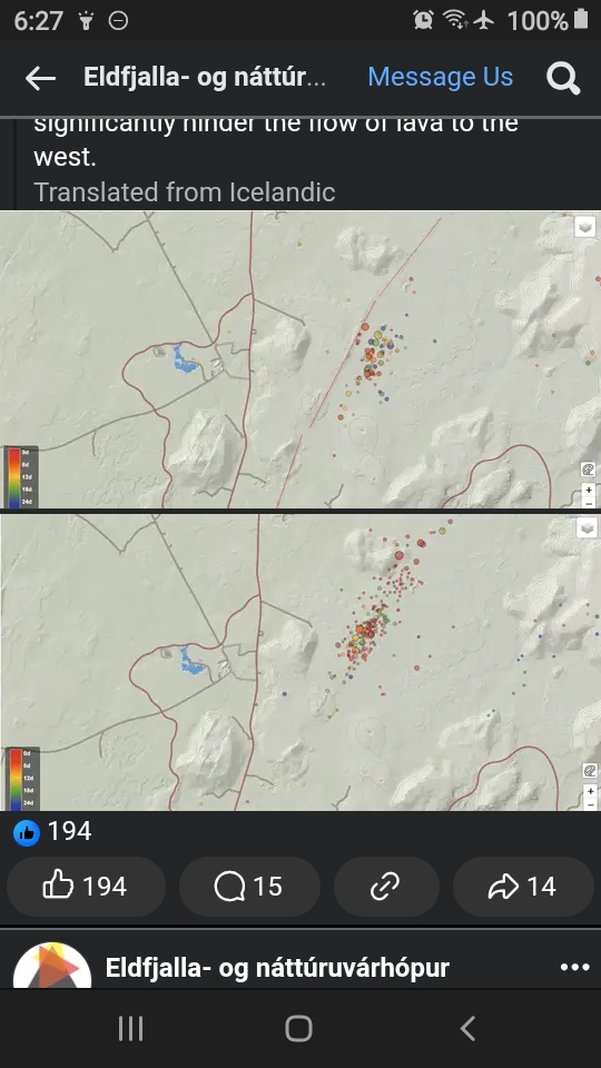
March 8, 2025, 6:20 p.m., Pacific: The Southern Volcanoes group notes on Facebook (though I used Google Translate and did a screenshot for the image):
Changed pattern in the earthquake activity?
The earthquake activity at the Sundhnúk crater series in recent weeks seems to show a slightly different pattern from what has been seen so far between eruptions in the eruption chain.
In recent weeks, the seismic activity has been occurring just east of the crater series itself. The activity is therefore somewhat parallel to the activity that was seen, for example, before the last eruption. This is clearly seen in the accompanying images, which show different periods. The first image shows the activity over the last 30 days, while the second is the activity over the last month before the last eruption, which began on November 21.
It is completely uncertain what this means and it is unlikely that much can be concluded from this changed pattern. If an eruption fissure were to open so far east, it would probably be good news for Svartsengi, as the crater series from previous eruptions would significantly restrict the flow of lava to the west.
Yesterday there was a little swarm in the Sundhnuk region northeast of Grindavik, with one quake almost up to M2, but it’s quiet now on the vafri.is graphic.
Still waiting…
