
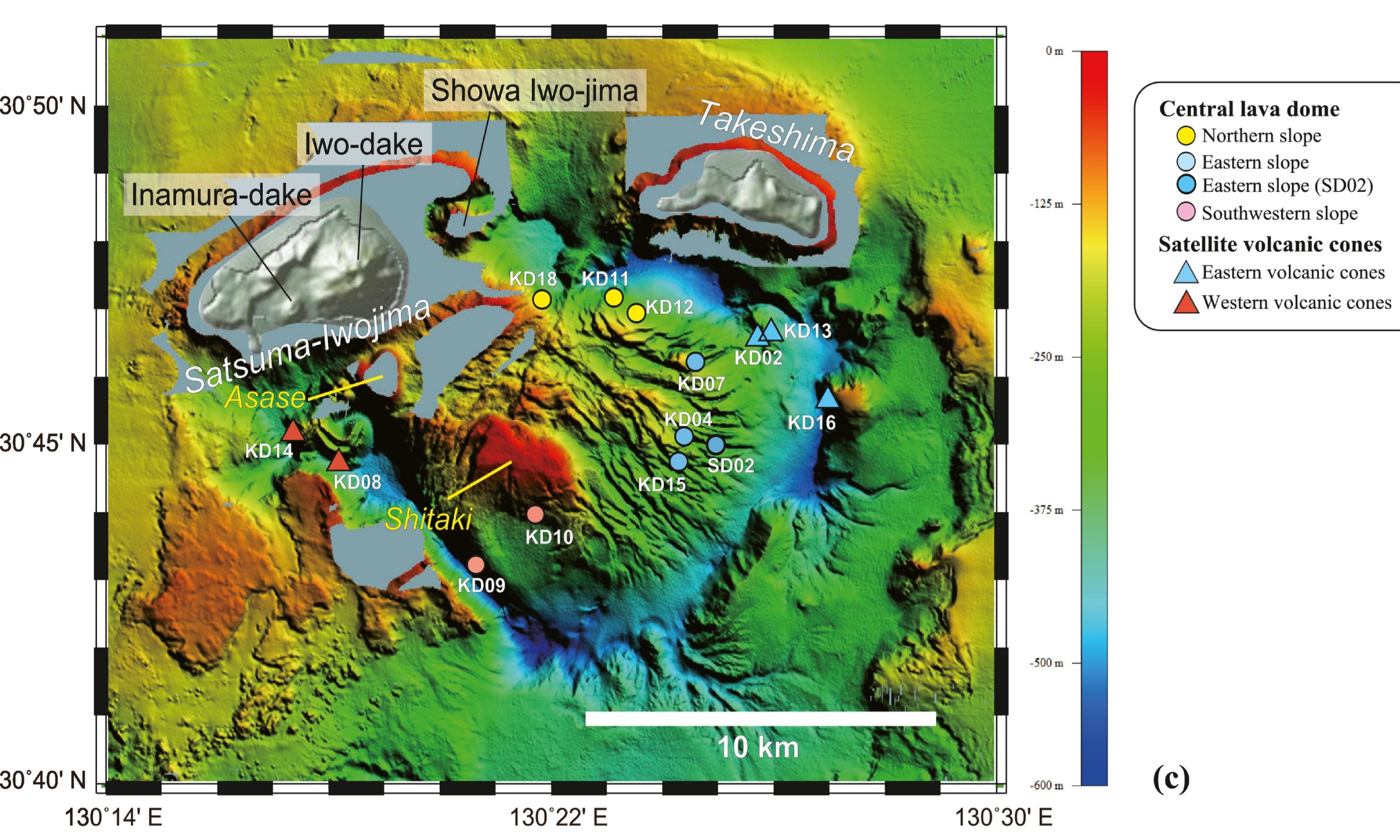
I like this bathymetry graphic of Japan’s mostly submerged Kikai Caldera (Hamada et al., Figure 1, CC BY-SA 4.0) because it looks like a happy face.

With some imagination… (Image: From Hamada et al., Figure 1, CC BY-SA 4.0)
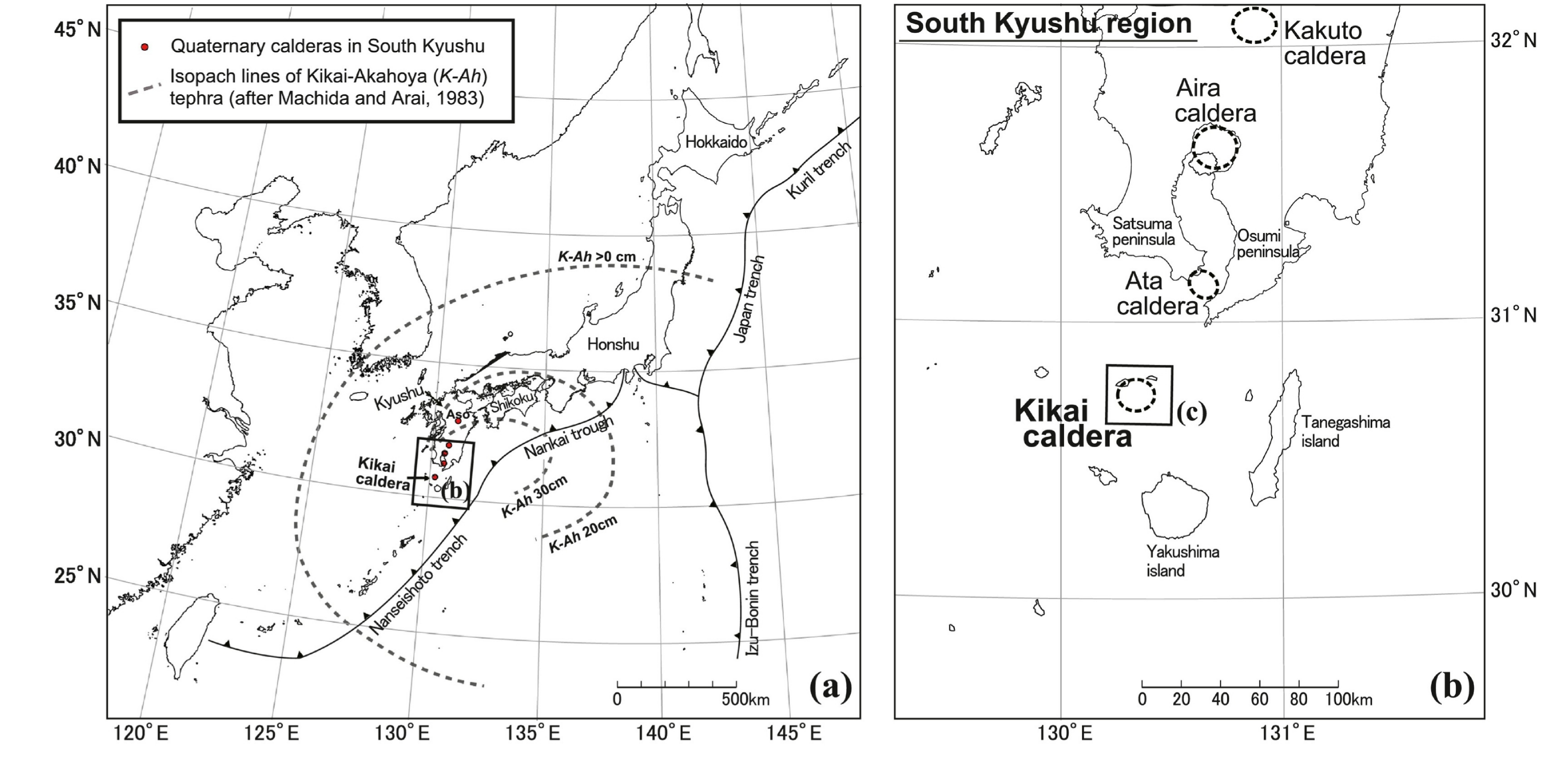
In reality, we’re looking at an underwater caldera complex located about thirty miles off the southern coast of Kyushu Island, near more than a million people. (GSJ; GVP)
Although it sits on the seafloor, Kikai does line up quite nicely with several calderas on Kyushu, including last week’s supervolcano — Aira, in Kagoshima Bay (with 2,610,000 human neighbors) — as well as the supervolcano we will meet next time, called Aso, a ways north of the bay (population within 60 miles: 6,507,000). (GVP)
(Happy thoughts, focus on happy thoughts…)
Getting creative with that colorful image, I can see a face outlined by Kikai’s roundish outer caldera, along the top and both sides, where tans and oranges indicate shallow water.

Maybe it’s a tan/orange helmet; maybe those are the hair and sideburn colors.
The “eyes” are those two islands above sea level, on the northern and western caldera rim. The white and gray shades used on the map to highlight Satsuma-Iojima and Takeshima islands enhance this appearance.
The happy face is wearing spectacles!
From Hamada et al., Figure 1, CC BY-SA 4.0)
It also has a red-tipped nose (VERY shallow water for the East China Sea, less than 450 feet deep) surrounded by wrinkled “cheeks” — it’s smiling!
The inner caldera has blue colors, denoting the deepest water, down to about two thousand feet. It makes a semi-circular grin around the “nose” and also forms a mouth saying “Oh!” (or maybe whistling), and the green “jaws” and “chin” are very pretty.
What’s the word for it when we draw imaginary images like this on some completely different real-life object?
“Pareidola,” that’s it.
It’s fun, and there’s no harm done. We should think happy thoughts when exploring a snoozing supervolcano. It keeps our courage up.
Kikai is not extinct. It has active hydrothermal activity and some occasional low-level to moderate volcanism on Satsuma-Iojima island that dusts local residents with a little ash from the Iodake stratovolcano every now and then. (GSJ; Hamada et al.; Maeno and Taniguchi, 2007; Tatsumi et al., 2018)
As well, there is evidence of minor eruptive activity down in the calderas along with some degassing on that submerged “red nose,” which is actually a giant lava dome that they discovered several years ago. (GSJ; Hamada et al.; Tatsumi et al., 2018)
Japan was able to keep its happy thoughts going after discovery of the world’s largest known lava dome by volume, lurking unexpectedly in an active supervolcano’s bubbling maw.
This pop singer —
— went down, along with volcanologists from Kobe University, to explore the dome for Japan’s public broadcaster NHK.
It’s really too bad that the resulting 1-1/2-hour NHK 2018 show (autotranslated) is not to be found on YouTube.
Kikai’s status
Kikai is only dozing.
But is it really a supervolcano?
Yes. It’s on the list of nine supervolcanoes (DeSilva and Self) that we are using as a guide.
But suppose we don’t just blindly follow what’s written down in a paper and instead check things out ourselves.
A major discrepancy immediately pops up.
Kikai’s most recent “big one” was only 7,300 years ago, according to the Geological Survey of Japan (GSJ), DeSilva and Self, and others (some put it at 6,300 years before present), while most people — including me, in the VEI 8’s post — say that Earth’s last known supereruption occurred in New Zealand some 26,000 years ago.
What gives?
Well, I’m not a scientist so I can’t say anything definitive.
Just quoting numbers from various studies (listed in the reference section), reported volumes for Kikai’s great Akahoya eruption 7,300 years ago range from 75 km3 through 183 km3 to 500 km3 or more of magma! (DeSilva and Self; LaMEVE; Shimuzu et al.; Tatsumi et al., 2018)
Only one of those numbers crosses the “super” mark.
Japan might have its own system (I’m not sure), but according to Self (2006), a supereruption involves at least 450 km3 of magma.
Most sources that I checked went with the smaller numbers, making Kikai’s Akahoya event incredibly large (VEI 7) but not “super.”
On the other hand, that “greater than 500 km3” figure (VEI 8) is supported by geoscience heavyweights.
It’s not just an academic debate, either, given the millions of people and vital infrastructure nearby.
Let’s describe that problem in terms of a VEI 5 submarine eruption (GVP) that most of us already have a feel for because it grabbed global attention on January 15, 2022 —
This was recorded by Tongan Geological Services the day before Hunga Tonga literally punched the sky.
Was Kikai’s “big one” —
- A VEI 7, “only” a hundred times bigger than the Hunga Tonga eruption?
- Or was it a true supereruption, VEI 8: 1,000 times bigger than Hunga Tonga?
Either way, the scale we’re dealing with here is mind-boggling, but VEI 8 is by far the worst-case scenario.
Since many supervolcanoes tend to repeat themselves (Wilson et al.), typically after intervals of tens to hundreds of thousands of years, it really should be established whether Kikai has ever had one.
That would also affect the work of statistics experts who are trying to figure out how often supereruptions happen — perhaps in a good way, since supereruptions are very rare events and 7,300 years ago is a lot closer to us in time than 26,000 years ago.
Good, that is, unless the scholars who suggest that supereruptions might occur in clusters are correct.
So many ifs about a hazard that operates over deep time and mostly underground (except for those apocalyptic moments when it breaks the surface); ifs that confront a species — H. sapiens — that has only walked the Earth for a few hundred thousand years and that only took to the air a century ago.
We know so much today, and yet so little.
🌋🌋🌋
What my reading on supervolcanoes shows is that, even for today’s well-equipped and very knowledgeable experts in Japan and around the world, the truly definitive story of any large caldera system and its eruptions is still very much a work in progress. (Brown et al.; Crosweller et al.)
Yet that story must be understood because of the great impact these eruptions have on humanity and our stuff.
Boffins and hazard mitigation specialists have their work cut out for them.
What does Kikai mean to the rest of us?
The catastrophic effects of such an eruption on Japan, unlikely as that is during our lifetimes (Tatsumi and Suzuki-Kamata), would also affect the world in many ways — social, economic, academic, and military, as well as through volcanically induced temporary climate change.
So maybe we should look into this a bit further, especially since Kikai is just one of three active supervolcanoes at Kyushu (the other two being Aira and Aso).
Kikai’s setting
Additional things are going on in Hamada et al.’s Figure 1, besides the colorful “happy face.”
For instance, there are those two line drawings up at the top. Here’s a close-up:
Note the peculiar linear shape of Kagoshima Bay. It’s only rounded at the northern end because of Aira’s caldera-forming supereruption there 30,000 years ago. (Image from Hamada et al., Figure 1, CC BY-SA 4.0)
On the right, see how Kikai lines up with Aira and other calderas?
That, in part, is due to a geologic depression of the Earth’s crust here that geologists call the Kagoshima Graben.
It starts near Kakuto Caldera, runs south-southwest under Kagoshima Bay, and continues across the seafloor all the way to Kikai. (Hasegawa et al.; Machida and Sugiyama; Maeno and Taniguchi, 2007)
Although there reportedly is an unusually high heat flow through the Kagoshima Graben — one nickname for it is “fire ditch” — grabens as landforms are common.
All it takes to form one is some land extension.
At Kagoshima, the stretching comes from processes involved with those two trenches shown in the left-hand image above, labeled “Nankai” and “Nanseishoto.”
Their presence means that this is a subduction zone.
Most of us have heard that Japan is part of the “Ring of Fire,” where one tectonic plate dives below another, causing powerful earthquakes and forming many active volcanoes.
Subduction around and under Kyushu apparently is rather complex, but we don’t need to get into all that (for some technical details, see Hata et al. and Mahony et al.).
This is just to bring up the fact that, generally speaking, supervolcanoes form in areas of extension, too. (Wilson et al.)
That’s why active supervolcanoes today are either in subduction zones or, as with Long Valley and Valles calderas in the US, they’re located in places where the crust is being stretched for other tectonic reasons. (Jellinek and DePaolo)
Yellowstone seems to be the only exception, but even there some volcanologists argue that it is related to Basin-and-Range extension. (Foulger et al.)
Kikai & Co. line up because of the Kagoshima Graben and also because they are part of the volcanic front — a typical feature (jargon alert) of subduction zones but one that doesn’t usually contain three supervolcanoes (and some lesser but still very explosive volcanoes).
I don’t know whether or how Kyushu’s subduction complexity might be a reason for that concatenation of calderas, and perhaps the boffins haven’t reached a consensus on it, either.
Fiery Kyushu challenges geoscientists big time!
🌋🌋🌋
The most densely populated parts of Japan, along with some key infrastructure, are downwind of eruptions on Kyushu.
This fact leads us to those odd “K-Ah __ cm” lines on the left image —
Here it is again.
They resemble the contours on a topographic map, but these lines measure volcanic ash depth, not landscape elevation.
The 20-cm line shows areas of Japan — basically southwest from the Nagoya/Osaka/Kyoto area — that gets at least 8 inches of ash; 30 cm, a foot or more, including Kyushu and islands off its southern coast as well as the southern tip of Shikoku island. The outside line marked “>0 cm” extends from the Sendai and Fukushima region all the way down to Okinawa, including as well the adjacent Pacific Ocean, Sea of Japan, and part of the Korean Peninsula — a total area of more than a million square miles (2,800,000 km2<). (Shimuzu et al.)
For the record, according to this USGS page, just 5 cm (2 inches) of volcanic ash can damage plants; 10-15 cm (4-6 inches) will completely bury soil and sterilize it by cutting off oxygen. Roofs collapse under the weight of 30 cm of ash.
In addition to all that is contamination of ground and water from toxic elements like fluorine that might leach out when ash gets wet.
Note how those K-Ah lines center around Kikai, with an eastward shift (because prevailing winds here blow from the west).
The Akahoya (K-Ah) ash
This is just layperson speculation, but I was curious about the word “Akahoya” and, by fiddling around with Google Translate, discovered that akairo and akai are Japanese adjectives used to describe a reddish color while oyu means (among other things) “bath.”
I don’t speak Japanese and so am just stumbling around in the dark, but the color and the association with water do appear relevant.
Orange is a reddish color, and Machida and Arai note that “Akahoya” is one of the names that farmers and soil scientists gave to an orange layer of very fine but glassy volcanic ash — quite a thick layer in some places.

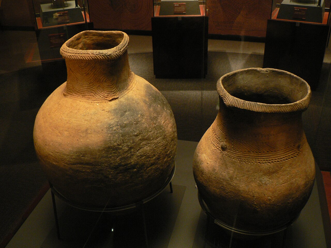
Akahoya seen at an archaeological site near Kirishima, on the north shore of Kagoshima Bay. (Image: Michael Gunther via Wikimedia, CC BY-SA 4.0)
Those who work the soil don’t care for Akahoya because it’s no good for agriculture.
Volcanic ash, in small quantities, is a fertilizer but not Akahoya — it doesn’t hold in water (this now is considered a plus, according to recent news that Akahoya has very useful water purification qualities). (Japanese Wikipedia)
Soil scientists were curious because of its peculiar qualities and also because they had no idea where this widespread volcanic deposit had come from.
Archaeologists joined the discussion, reporting that the Akahoya layer marks a major break in human history on Kyushu.
Takuma-sa via Wikimedia, CC BY-SA 3.0
For those who can read this record, artifacts in the stratigraphic layers below Akahoya show how paleolithic human culture developed here.
First came the stone tools, which newcomers to the Japanese archipelago brought with them. Eventually they figured out how to use clay. (Machida, 2002)
Then comes the Akahoya layer, with no archaeological material at all, and then a pottery culture shows up again — a different culture that apparently developed somewhere else and then moved into the Kyushu area.
Whatever eruption laid down the Akahoya ash had wiped out prehistoric people living nearby!
Centuries after Akahoya (soil forms slowly), conditions had improved to the point where the area could be reinhabited.
Millions live here now, so the search was on to find out which of Japan’s many volcanoes is such a hard-hitter.
It took some work, but geologists finally connected Akahoya to Kikai’s massive 7300-year-old eruption.
The supereruption
Let’s take a ferry from Kagoshima to Ground Zero.
It has English subtitles.
The ferry ride takes about three hours, but immense pyroclastic flows as Kikai Caldera collapsed probably covered the return distance in minutes.
This video was made for fun reasons, not as a geology lesson — the channel showcases small-town Japan and its videos probably also give viewers something interesting to watch as they exercise on a treadmill (which is probably why this fit-appearing gentleman takes so many loud breaths and has such heavy footsteps while exploring Takeshima; he’s enhancing the viewer experience).
Still, geology is always with us and the scenery shows us what those parts of Ground Zero that are above water look like today.
The Kikai-related part comes first, but you might want to watch the entire thing. After he leaves the Kikai sign and starts walking around Takeshima Island we do see outcrops and cliffs formed by pyroclastic flows that hardened as they cooled.
There is also a long-distance view of Iodake Volcano on Satsuma-Iojima Island; it looks surprisingly large to those of us who have only seen these two islands on Kikai’s northern caldera rim as “eyes” on a bathymetric “happy face.”
While the exact location of the Akahoya eruption vents is unknown, they possibly were near Satsuma-Iojima. (Maeno and Taniguchi, 2007, 2009)
Of course, no one knows for sure what was here 7,301 years sgo.
Takeshima and Satsuma-Iojima islands were present (GSJ) though not yet draped with up to a hundred feet or more of young ignimbrite and pumice.
After all, there are older igneous strata here and elsewhere showing that Kikai has exploded several times over the last 150,000 years, as well as hosting smaller eruptions in between blasts. (Hanyu et al.; Maeno and Taniguchi, 2007; Tatsumi et al., 2018)
Maeno and Taniguchi (2009) suggest that Kikai was an actual volcano towering over the sea before the caldera collapse, but Hanyu et al. have found no clear evidence of such a structure.
Let’s be arbitrary and say that the Kikai supereruption began on January 12, 5300 BC.
Let’s also assume that Shimuzu et al. are correct in saying that it probably occurred close to or just below sea level so I can illustrate it with images that will bring Hamada et al.’s “happy face” graphic to life for us, even though they are from 21st-century Hunga Tonga, in another part of the world.
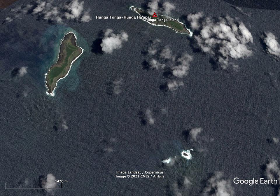
Figure 28, Global Volcanism Program/Google Earth, taken in 2013.
There’s a superficial resemblance, with both volcanoes taking up most of the picture but lurking underwater south of their islands, invisible to satellite view.
However, Kikai’s Satsuma-Iojima and Takeshima islands are somewhat larger than Hunga Tonga and Hunga Ha’apai, shown above. Too, at the time of this image (2013) Hunga was a seamount and had a flat top.
After its big one, Hunga was still a seamount; the flat top now had a big hole in it.
No one can be sure what Kikai looked like before its supereruption, because that event left a big hole (caldera) in the seafloor where, possibly, a volcano had once stood.
Similarities between Kikai and Hunga Tonga only go so far.
The Akahoya eruption started off with a plinian eruption — two of them, in fact, occurring over some twenty-eight hours. (Maeno and Taniguchi, 2007)
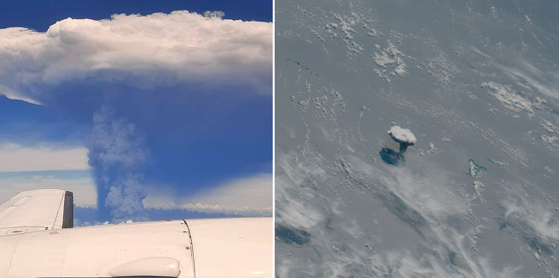
The first plinian eruption was rather small. The second one raised a column whose estimated height was about twice as high as this plume from a December 20, 2021, eruption at Hunga Tonga. (Image: Figure 31, Global Volcanism Program/Kimberly Hoyla/Pacific Newsroom/GeoKompsatSimon Proud)
Ash from these plinian eruptions rained down all over southern Kyushu as well as on the islands near Kikai.
That initial umbrella cloud must have been impressive, but the Akahoya eruption was only in Phase 1. Material that would fall on central and southern Japan as the K-Ah ash was still on its way up to the surface.
As Maeno and Taniguchi describe the sequence of events at Kikai in their 2007 paper (using words as well as a very nice but copyrighted graphical representation of the eruption in Figure 14), Phase 2 began when the eruption plume began to pulsate up and down for some reason.
Magma and seawater interacted, forming this eruption’s distinctive glassy ash fragments.
In between plinian pulses, pyroclastic flows surged outward from the widening column’s base. (Maeno and Taniguchi, 2009)

The lower two images in this screenshot from a December 30, 2021, video show base surges rushing out of Hunga Tonga’s plume. (Image: Figure 38, Global Volcanism Program/Tonga Geological Services)
The ignimbrite deposits of those base surges today are only seen on the islands. They were massive events but could not yet cross the water to Kyushu. (Maeno and Taniguchi, 2007)
One might think that the pyroclastic flows needed more energy input to do that, but as I understand it, gas content is the key factor.
Friction doesn’t have much effect on pyroclastic flows that have been diluted by hot gases. These can cross water or climb steep slopes and always travel far. (Oppenheimer)
Even when eruptions aren’ supersized.
Lots of hot, gassy magma was on the move as the chamber’s roof possibly began to sag. Around this time, too, there were some tsunami-generating earthquakes tha affected nearby coasts. (GSJ; Machida, 2002)
Then came the climactic eruption and the biggest pyroclastic flows, which did reach and overwhelm all nearby islands as well as Kyushu’s southern coasts.
🌋🌋🌋
It is impossible to see inside an active pyroclastic current but we can be fairly sure that most (excepting the most dilute and turbulent) consist of a denser basal flow of ash, blocks of lava and other debris picked up en route, which travels beneath a soaring cloud of finer ash. The upper parts actually behave like Plinian eruption columns owing to their heat energy and turbulence. They entrain air and, enhanced by the sedimentation of the denser components of the flow, develop buoyant thermal plumes that punch up into the sky. These phenomena are known as ‘ co-ignimbrite plumes’, or more lyrically as ‘phoenix clouds’. Unlike eruption columns developed above erupting vents, phoenix clouds do not have a lower gas-thrust region, and, for a given intensity, they do not reach so high into the atmosphere as a Plinian plume (though they can still readily soar to altitudes of 20 kilometres or more). As eruptions get larger (beyond M e 6), their plumes are likely to be more intense and prone to column collapse. The very largest eruptions are, in essence, pyroclastic-current eruptions and their deposits consist of roughly equal measures of ignimbrite and fallout from phoenix clouds…
— Oppenheimer, in “Eruptions That Shook The World”
This phoenix cloud above the deadly final ignimbrite surge — covering more than a million square miles of land and sea — is where Akahoya comes from.
Afterwards, it would take plants, animals, and surviving human beings many centuries to rise once more from the ashes.
Points to ponder
- How do you monitor a submerged supervolcano?
The Geological Survey of Japan page has some information on that. The caldera’s walls and presence of Satsuma-Iojima and Takeshima make it difficult to use seismic waves to study the magma chamber, but they have worked out alternate ways to keep an eye on restless Kikai.
- The gigantic lava dome raises many questions, most notably whether it is somehow related to the Akahoya eruption — apparently not, in the opinion of Tatsumi et al, 2018.
Research continues (although, thus far, they haven’t called on the pop musician contingent again), since the feature is unique to Kikai (as far as anyone knows — calderas on the seafloor are hard to find, let alone study, and very few have yet been recognized) and is quite a large one to have formed in seven millennia, a blink of geologic time.
- What would be the best steps for Japan to take, if experts did see signs of another impending “big one” at Kikai, or elsewhere?
I can’t begin to answer that, but volcanologists, public officials, and a host of other specialists are undoubtedly working on it now that everyone knows about this lurking threat.
Next time — A much bigger eruption than anything yet seen in the geological records of Aira and Kikai.
Sources:
Brown, S. K.; Crosweller, H. S.; Sparks, R. S. J.; Cottrell, E.; and others. 2014. Characterisation of the Quaternary eruption record: analysis of the Large Magnitude Explosive Volcanic Eruptions (LaMEVE) database. Journal of Applied Volcanology, 3: 1-22.
Crosweller, H. S.; Arora, B.; Brown, S. K.; Cottrell, E.; and others. 2012. Global database on large magnitude explosive volcanic eruptions (LaMEVE). Journal of Applied Volcanology, 1: 1-13.
DeSilva, S. and Self, S. 2022. Capturing the extreme in volcanology: the case for the term “supervolcano”. Frontiers in Earth Science, 10: 859237.
Foulger, G. R.; Christiansen, R. L.; and Anderson, D. L. 2015. The Yellowstone “hot spot” track results from migrating basin-range extension. The Interdisciplinary Earth: A Volume in Honor of Don L. Anderson: Geological Society of America Special Paper, 514: 215-238.
Geshi, N. 2020. Volcanological challenges to understanding explosive large-scale eruptions. Earth, Planets and Space, 72: 99
Global Volcanism Program. 2025. Kikai. https://volcano.si.edu/volcano.cfm?vn=282060
Hamada, M.; Hanyu, T.; McIntosh, I. M.; Tejada, M. L. G.; and others. 2023. Evolution of magma supply system beneath a submarine lava dome after the 7.3-ka caldera-forming Kikai-Akahoya eruption. Journal of Volcanology and Geothermal Research, 434: 107738.
Hanyu, T.; Seama, N.; Kaneko, K.; Chang, Q.; and others. 2024. Submarine cores record magma evolution toward a catastrophic eruption at Kikai Caldera. Communications Earth & Environment, 5(1): 428.
Hasegawa, T.; Mochizuki, N.; Shibuya, H.; Nishihara, A.; and others. 2024. Paleomagnetic study of the 30 ka Aira caldera-forming eruption and 60–45 ka Iwato pyroclastic flow deposits, southern Kyushu, Japan. Earth, Planets and Space, 76(1): 161.
Hata, M.; Uyeshima, M.; Handa, S.; Shimoizumi, M.; and others. 2017. 3‐D electrical resistivity structure based on geomagnetic transfer functions exploring the features of arc magmatism beneath Kyushu, Southwest Japan Arc. Journal of Geophysical Research: Solid Earth, 122(1): 172-190.
Hayakawa, Y. 2023. Kikai. One Million Year Tephra Database. https://hayakawayukio.jp/database/index.php?mode=&kind=1m&sheet=4&pointer=0&rpp=50&date1=&date2=&mg1=&mg2=&type1=1&type2=1&type3=1&type4=1&type5=1&vlcn=Kikai&_multi=&search=SEACH Last accessed January 5, 2025.
Jellinek, A. M., and DePaolo, D. J. 2003. A model for the origin of large silicic magma chambers: precursors of caldera-forming eruptions. Bulletin of Volcanology, 65: 363-381.
Large Magnitude Explosive Volcanic Eruptions (LaMEVE) database. ___. Kikai. https://vogripa.org/searchVOGRIPA.cfc?method=search&ymax=&xmin=&xmax=&ymin=&volcanoName=Kikai&alternateVolcanoName=&volcanoType=any&dateType=dateTypeBP&eruptionDate1=&eruptionDateDay1=dd&eruptionDateMth1=mm&eruptionDateYr1=yyyy&eruptionDate2=&eruptionDateDay2=dd&eruptionDateMth2=mm&eruptionDateYr2=yyyy®ion=any&subRegion=any&MagnitudeType=magnitude&magnitudeFrom=&magnitudeTo=&composition=any&bulkVolumeFrom=&bulkVolumeTo=&dreVolumeFrom=&dreVolumeTo=&columnHeightFrom=&columnHeightTo=&airTephraVolumeFrom=&airTephraVolumeTo=&submitButton=Search Last accessed January 4, 2025.
Machida, H. 2002. Impact of tephra forming eruptions on human beings and the environment. Global Environmental Research — English Edition, 6(2): 61-68.
Machida, H., and Arai, F. 1978. Akahoya ash-a Holocene widespread tephra erupted from the Kikai caldera, south Kyushu, Japan. The Quaternary Research (Daiyonki-Kenkyu), 17(3), 143-163. (Abstract only.)
Machida, H., and Sugiyama, S. 2003. The impact of the Kikai-Akahoya explosive eruptions on human societies. In Natural disasters and cultural change (pp. 313-325). Routledge.
Maeno, F., and Taniguchi, H. 2007. Spatiotemporal evolution of a marine caldera-forming eruption, generating a low-aspect ratio pyroclastic flow, 7.3 ka, Kikai caldera, Japan: Implication from near-vent eruptive deposits. Journal of Volcanology and Geothermal Research, 167(1-4): 212-238.
Maeno, F., and Taniguchi, H. 2009. Sedimentation and welding processes of dilute pyroclastic density currents and fallout during a large-scale silicic eruption, Kikai caldera, Japan. Sedimentary Geology 220(2009): 227-242.
de Maisonneuve, C. B.; Forni, F.; and Bachmann, O. 2021. Magma reservoir evolution during the build up to and recovery from caldera-forming eruptions–a generalizable model? Earth-Science Reviews, 218: 103684.
Miller, C. F. and Wark, D. A. 2008. Supervolcanoes and their explosive supereruptions. Elements, 4(1): 11-15.
Moriwaki, H., Shinto, K., and Kobayashi, T. 1991. Quaternary Tephra Studies in the Kyushu District, Southern Japan With Special Reference to Gigantic Pyroclastic Flow Deposits. The Quaternary Research (Daiyonki-Kenkyu), 30(5): 329-338.
Moriwaki, H.; Nakamura, N.; Nagasako, T.; Lowe, D. J.; and Sangawa, T. 2016. The role of tephras in developing a high-precision chronostratigraphy for palaeoenvironmental reconstruction and archaeology in southern Kyushu, Japan, since 30,000 cal. BP: an integration. Quaternary International, 397: 79-92.
Nagaoka, S. 1988. A silicic pyroclastic-flow eruption and pyroclastic surges from the Kikai Caldera volcano in the last interglacial stage. Journal of Geography (Chigaku Zasshi), 97(3): 156-169. (Abstract only.)
Newhall, C. G., and Self, S. 1982. The volcanic explosivity index (VEI) an estimate of explosive magnitude for historical volcanism. Journal of Geophysical Research: Oceans, 87(C2): 1231-1238.
Oppenheimer, C. 2011. Eruptions That Shook the World. Cambridge: Cambridge University Press. Retrieved from https://play.google.com/store/books/details?id=qW1UNwhuhnUC
Self, S. 2006. The effects and consequences of very large explosive volcanic eruptions. Philosophical Transactions of the Royal Society A: Mathematical, Physical and Engineering Sciences, 364(1845): 2073-2097.
Shimizu, S.; Nakaoka, R.; Seama, N.; Suzuki-Kamata, K.; and others. 2024. Submarine pyroclastic deposits from 7.3 ka caldera-forming Kikai-Akahoya eruption. Journal of Volcanology and Geothermal Research, 448: 108017.
Tatsumi, Y., and Suzuki-Kamata, K. 2014. Cause and risk of catastrophic eruptions in the Japanese Archipelago. Proceedings of the Japan Academy, Series B, 90(9): 347-352.
Tatsumi, Y.; Suzuki-Kamata, K.; Matsuno, T.; Ichihara, H.; and others. 2018. Giant rhyolite lava dome formation after 7.3 ka supereruption at Kikai caldera, SW Japan. Scientific Reports, 8(1): 2753.
Uchiyama, J.; Kuwahata, M.; Kowaki, Y.; Kamijō, N.; and others. 2023 Disaster, survival and recovery: the resettlement of Tanegashima Island following the Kikai-Akahoya ‘super-eruption’, 7.3 ka cal BP. Antiquity, 97(393): 557-575.
Wikipedia 2024. Mishima village. https://en.m.wikipedia.org/w/index.php?title=Mishima,_Kagoshima&wprov=rarw1 Last accessed January 7, 2025.
Wikipedia (Japanese). 2024. Akahoya ash (via Google Translate). https://ja-m-wikipedia-org.translate.goog/wiki/%E9%AC%BC%E7%95%8C%E3%82%A2%E3%82%AB%E3%83%9B%E3%83%A4%E7%81%AB%E5%B1%B1%E7%81%B0?_x_tr_sl=auto&_x_tr_tl=en&_x_tr_hl=en-US&_x_tr_pto=wapp Last accessed January 7, 2025.
Wilkins, A. 2024. Volcanic eruption 7300 years ago was record-breakingly huge.” New Scientist, vol. 261, no.3480, p. 18. Gale Academic oneFile, link.gale.com/apps/doc/A784452840/AONE?u=oregon_oweb&sid=google-Scholar&xid=dd25514c. Accessed January 4, 2025.
Wilson, C. J.; Cooper, G. F.; Chamberlain, K. J.; Barker, S. J.; and others. 2021. No single model for supersized eruptions and their magma bodies. Nature Reviews Earth & Environment, 2(9): 610-627.
