
The image above — which is actually Figure 1 from Pratama et al. (jargon alert), CC BY-SA-NC 4.0 — suggests that learning about volcanology can be great fun.
And it is!

Fig. 2, Pratama et al., CC BY-SA-NC 4.0
You get to color, and they also let you go out and climb around and collect rocks.
But they also make you go out when the weather is bad and the outcrop is difficult to reach. And besides colorful maps there are lots of calculations to make, tables and figures to build, and papers to collaborate on, as well as various computer programs to run and, if necessary, invent in order to interpret all the data that you’ve obtained from those rocks and various other sources.
Also, your kids might wonder if your job is going to murder you.
Nevertheless, many people do this work and/or support it in a variety of ways (some of which put them in the line of fire, too) because real-world volcanology is always about protecting humanity and our stuff from the violent excesses of this great stone giant that we live on.
And Krakatoa is Exhibit A when it comes to geological violence during human history, because of the 1883 eruption:
- Its toll in lives and damages
- Its global effects
- Its occurrence soon after the historical moment when many parts of our world connected up through submarine and overland telegraph lines, making Krakatoa’s 1883 cataclysm the first globally reported (and globally studied) natural disaster.

Fig. 4, Pratama et al., CC BY-SA-NC 4.0
That’s Krakatoa — or Krakatau, if you like. I’m going to mix the terms from now on, just as they are mixed in the scientific literature and, in Indonesia, in daily life.
Figure 4 up there shows Krakatoa as those authors think it might have looked at three stages of its existence.
Old Krakatoa, the big single volcano on the left, is mostly hypothetical, as is the magmatic plumbing depicted in all three images. (This is only one of many ideas about the volcano’s distant past and its magma storage system.)
That plumbing isn’t getting more threatening over time — it was the earlier versions of Krakatoa that had massive eruptions, after all.
That takes a lot of magmatic “brewing,” so their plumbing likely was quite impressive!
The system on the right is more detailed because it’s the only one available for modern instruments to study.
Only the last two real-world incarnations of Krakatoa are known in any detail: the island that exploded in 1883 (middle image), and Anak Krakatau (that small single volcano on the right), the “Child of Krakatoa” that dramatically rose out of the sea in the 1920s and then slid half of its bulk back into the sea one dark night in December 2018 before embarking on a new round of rapid growth.
But it’s hard to fill in ALL the lines on any picture of Krakatoa, including this blog series of written descriptions.
It’s a very unusual volcano and hides many of the features that volcanologists need to study in order to produce Krakatoa hazard maps, predict possible future behavior, and so forth.
Also, plate tectonics makes things here quite complex, as we will see (very briefly) in the last section.
I’m going to lay down a few lines in the form of questions about Krakatoa, inspired by Anak Krakatau’s recent behavior.
Then I’ll color in between them, using very, very light pastels because I am a layperson.
So let’s relax along the Sunda Strait in some rocky cove as the tide slowly comes in —
— or by a campfire on a beach in Banten Province (parts of which were hit so hard in 1883 that they were abandoned and have since become a nature preserve where you can photograph rare Javan rhinoceroses, as these two men did earlier that day):
But then, as the stars begin to twinkle and the pleasant odors of wood smoke and sea air mingle, you remember that some of the locals still practice haul kelembak here.
According to Sururoh et al., haul is a commemoration of someone after their death, kelembak means “thrown or dragged by large waves,” and yes, this is a ceremony honoring family members who were among Krakatoa’s tens of thousands of tsunami victims in 1883.
Also recall that most of the huge influx of newcomers settling down along these vulnerable coasts have no family memories of what Krakatau can do, no clue on how to take that red spot of fire out in the Strait personally.
The December 2018 collapse of Anak Krakatau was a reminder, but a comparatively small one.
Sitting there on the beach as twilight darkens into night, and even though you know it’s the twenty-first century and Anak Krakatau is now surveilled closely, you can’t help but cast a quick, nervous glance in its direction and wonder —
How good is that new tsunami warning system?
Krakatoa is one of the few volcanoes in the world that both needs a TGV (tsunami generated by volcanism) early warning system and has one. (The other volcanoes are Hunga Tonga, Stromboli, and the volcanoes that form Hawaii’s Big Island – that’s it, out of hundreds of active potential tsunami generators worldwide.)
Volcanigenic tsunami detection is such a new field that everything about the Child’s monitoring network must be based on theory — we will all find out how good that system is when Anak Krakatau decides to test it.
Waiting… (The Child, over to the left of that big tree, actually was quite active, this particular April 2020 night, but the weather was uncooperative. Luckily, Anak wasn’t in a tsunami mood and did not cause any sudden changes in the marina’s water levels, which is what the camera is monitoring. Since then, they’ve been able to set up communication links for stations much closer to the temperamental Child than this.
Background
Research into volcano-generated tsunamis intensified after Anak Krakatau’s deadly collapse in 2018. (Schindele et al.)
This ongoing work already has helped tsunami experts, volcanologists, and emergency managers a lot, and they continue to do everything possible to mitigate hazards at Krakatoa (see Schindele et al. for more information as well as a detailed look at Anak’s monitoring network as of this writing).
Nevertheless, there are two major challenges that anyone who wants to put a tsunami warning system on a volcano must overcome, and it’s hard going with each one.
Technology
Current early-warning systems aren’t designed for rare volcano-caused tsunamis.
They’re designed for tsunamis from regular (a/k/a “tectonic”) earthquakes, which are much more common.
Tectonic earthquakes are straightforward: rock breaks, disturbing a body of water as well as generating seismic waves that travel through the ground faster than the tsunami moves and that can be modeled fairly easily for an early-warning system’s algorithm (‘easily,’ says this layperson who has never designed or used any sort of modeling software in her life! 😉).
Like many countries in tsunami-prone areas, Indonesia has an early-warning system in place (called InaTEWS, installed after the 2004 tsunami):
There is also a post-2018 InaTNT, but I found little information on whether or how it has been implemented.
On December 22, 2018, seismometers detected the Child’s cone collapse —

Walter et al., Figure 4, CC BY-SA NC 4.0.
— but Indonesia has many earthquakes. Too, seismicity from the volcanic cone landslide was moderate, compared to the strong tectonic signal that all tsunami early-warning systems recognize as a threat. The automated system did not notify operators of the event. (Zorn et al.)
Volcanoes, unlike tectonic earthquakes, are not at all straightforward.
Multiple unpredictable volcanic factors can contribute to eruption and/or collapse force(s) that might cause a big wave — or they might not come together at all on a human time scale or they might do so RIGHT NOW (as happened in 2018). To make things even more tricky, these tsunami-generating factors constantly change during eruptions, in ways that are not well understood. (Schindele et al.)
Try modeling that!

Figure 1 in Schindele et al. (CC BY-SA-NC 4.0) shows the many ways that volcanoes can mess you up with a tsunami. More than one of these can happen during an eruption, sometimes causing tsunamis all at the same time.
Yet, in view of the high impact these low-probability events can have — Krakatoa claimed more than thirty thousand lives with tsunamis on August 26 and 27, 1883 — experts today are trying to model that.
It sounds impossible, but it must be done: volcanoes that are near or in water give us little tsunami warning.
To save lives, “[o]ften precomputed scenarios are the only feasible option.”
That quote is from Schindele et al., who suggest a hybrid approach of using computer-modeled scenarios to train artificial intelligence that can then (hopefully correctly) learn more and more as it rapidly analyzes each new event and estimates the hazard.
We need all the lead time we can get!
Spreading the alert
Some volcanoes, like Italy’s Stromboli and Taal in the Philippines, don’t give us much of a chance.
They are close to shore (Stromboli has people living on its flank!) and they have a history of generating lethal tsunamis.
Krakatoa, on the other hand, is about 25 miles (40 km) away from land.
Pyroclastic flows somehow reached out over that distance and killed people in Ketimbang, Sumatra, during the catastrophic 1883 eruption (Global Volcanism Program; Winchester), as did tsunamis that reminded some survivors of a line of hills moving over the strait.
In the here and now, much less explosive Anak Krakatau wasn’t expected to produce such pyroclastic flows — and it has not.
Tsunami warning time was not expected to be an issue, either.
Although the volcano was known to be structurally unstable (Camus et al.; Cutler et al.), computer models showed that sea waves from a collapse at Anak Krakatau would take 35-45 minutes to reach the western Java coast. (Giachetti et al., 2012; in the event, the first wave on December 22, 2018, came in 32 minutes after the collapse signal began, per Priyanto et al.)
Everyone thought that the InaTEWS system would pick up trouble right away and that people on the coasts would see the incoming wave early enough to escape.
Only, the system misidentified the seismic signal as just another earthquake, and out on the Strait, it was night — a holiday Saturday night, with plenty of interesting things going on along both shores — and Anak Krakatau, miles across the water, was hard to see in cloudy weather.
Even this photographer, who made that video a few hours before Anak Krakatau failed and who has much experience on active volcanoes, missed the significance of that moment (not recorded on camera) when something — what later turned out to be surtseyan eruption plumes that occurred as soon as the landslide had broken open Anak’s magma-filled throat — combined with meteorological clouds to hide the Child from view. (Hunt et al.)
Yes, a volcano can erupt violently and suddenly just a few tens of miles across the water from crowded beaches at night and nobody will see it!
What if InaTEWS had sent an alert — would that have saved lives?
Because Krakatau is so far from shore, yes, a public warning probably would have been issued in time.
I say “probably” after reading the article by Wicaksono et al.
Globally, with only one exception that I know of, there is a delay in warning the public and local authorities when an early-warning system of any type issues a tsunami alert.
The exception is Italy’s Stromboli.
Landslides, as well as pyroclastic flows, cause tsunamis at Stromboli.
Here, waves can reach the island’s residents in less than three minutes, so the early-warning system is wired directly into local sirens, which blare as soon as the alert is issued (it’s also immediately sent by email and text to authorities in other vulnerable areas that have a somewhat longer lead time. (Necmioglu et al.)
Stromboli is a very active volcano and so this system already has been tested — successfully! — multiple times. (Necmioglu et al.; Schindele et al.)
When time isn’t a crunch, emergency managers first try to verify the system’s alert, and rightly so — no one wants to lose public trust with a false alarm!
Most places have some sort of organizational flowchart — like the one in Indonesia that we saw in the InaTEWS video — for verification and to funnel the warning out to those who need it.
That lengthens warning time.
On average, it takes about seven minutes to generate a tsunami warning once detection systems send an alert. (Necmioglu et al.; Zorn et al.)
A public alert issued three minutes later is considered rapid.
Minimizing the amount of time spent on this last step in tsunami warning transmission is hard, both generally and in Indonesia’s specific case (see Necmioglu et al. and Wicaksono et al., respectively, for details).
However, overall, Krakatoa is at the forefront of research into tsunamis caused by volcanoes — more discoveries and stronger safeguards will come with time and, hopefully, without such a high cost.
🌊🌊🌊
Other questions raised by Krakatau get into less familiar territory even for the boffins, let alone us laypeople.
Yet we all are curious about Krakatoa — and the people of Indonesia, particularly those who live and work along the Sunda Strait on southeastern Sumatra and western Java, are stakeholders in anything related to it.
(Sorry, movie fans: Krakatoa is west of Java!)
Let’s briefly look at chances for another collapse at the Child of Krakatoa; what else might happen here; and, ultimately, why this relatively small part of the strait is such a big problem.
The sections get shorter and shorter because these are among the many big questions that some of the best minds on this planet are still trying to answer.
This layperson can’t get into all that but can, at least, show you some interesting things about Krakatoa that you might not have been aware of.
Will Anak Krakatau collapse again?
The Child appears to be preconditioned for collapse. (Hunt et al.; Walter et al.)
That is, it sits very close to the edge of a steep submarine cliff which is part of the 1883 caldera rim; Anak also has a built-in structural weakness (called a “tuff ring”) that apparently serves as a sliding surface for flank collapse.
Pictures are worth a thousand words, especially colorful pictures, although some words are necessary to describe them:

Figure 16, bathymetry of the Krakatoa islands, from Ismail et al., 2020, CC BY-SA-NC 4.0
The 1883 caldera
The top graphic in Figure 16 shows signs of at least one Krakatoa caldera — the deep blue hole, all that’s visible now from 1883 — although these researchers also see evidence of a much older blast, hard to date, that left behind the islands of Panjang (Lang) and Sertung (Verlaten), as well as a little rocky stub in between them that the Dutch named Polish Hat, which vanished in the 1883 paroxysms.
Just as an aside for now, note also that the seafloor all around this funky archipelago appears to be flat.

As we’ll see in the last section, it is actually part of a deep valley, called the Krakatau Graben, which is filled to the brim with more than ten million years’ worth of volcanic debris! (Susilohadi et al., Figure 10 and paper’s text)
That tall cone on the right in Figure 16 (Ismail et al.) is what’s left of Rakata Volcano.
Until August 27, 1883 — when it was basically sliced in half during caldera formation — Rakata was a stratovolcano on Krakatoa Island. It was the southernmost part of a north-south line that included the island’s other two volcanoes — Danan (middle) and Perboewatan (north).
Rakata, when it was whole, was labeled “R” on this 1883 map by Captain H. J. G. Ferzenaar — the last person known to have set foot on Krakatoa Island.
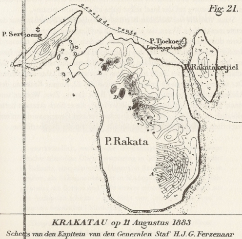
Figure 21 is listed in R. D. M. Verbeek’s “Krakatau,” although I did not see figures in a quick look through this online version.
Captain Ferzenaar made this topographic map two weeks before the final paroxysms began. Part is blank because he did not go there. The island was erupting, particularly around Danan, “D,” through multiple vents and there also were active fumarole fields.
Too close to the edge
Today we can make bathymetry maps, and on the bottom map of Figure 16 we see a close-up of Anak Krakatau:

There’s the “active cone” that Anak began growing through its old crater lake in 1959-1960. See how close it is to that deep blue caldera rim?
Starting in 1963, all the cone’s lava flows went that way, too, building it out even closer to the void. (Walter et al.)
A tuff ring “scar”
Anak’s other failure factor is labeled “old crater’s rim” on that close-up — a ring of volcanic tuff built out of eruption debris that collected there from 1927 to 1959-1960, when the Child was about as high as it is now after its 2018 collapse and some regrowth.
That tuff ring seems to be Anak Krakatau’s weak spot — as more than one collapse has shown:

Figure 2, Hunt et al. (CC BY-SA-NC 4.0)
“A” shows the 1940 failure plane, very similar to the one in 2018 and close to what was the tuff ring/cone interface in the 1960s and 1970s. (“E” is speculation on the topic Hunt et al. were researching.)
It’s surprising how similar the volcano looks after collapses in 1940 (“C”) — about twenty years before the cone made its debut — and on May 26, 2019 (“D” in that figure), after the latest collapse!
🌋🌋🌋
Perhaps the real question here isn’t so much whether Anak Krakatau will collapse again.
Perhaps it is whether Anak will grow another cone —
What will happen next?
First, what did happen after the December 2018 collapse?
Going by Global Volcanism Program (GVP) reports on its website, surtseyan eruptions continued for a while, but by January 9, 2019, Anak Krakatau had closed off its conduit again and formed the current crater lake.
After that, having increased its greatly diminished bulk by more than ten percent (Walter et al), Anak was quiet for more than a month.
Cutler et al. suggest that the volcano’s magmatic plumbing system might have returned to equilibrium pressurization by this time.
Nice recovery for a volcano that suddenly lost the upper hundred feet or so of its conduit — in mid-eruption!
But Krakatoa never rests for long.
Instead of going off, waning over time, and finally stopping for a while (as many volcanoes) do), Krakatoa repeats itself (Pratama et al.), as we’ll see later on.
Anak Krakatau woke up again, with more surtseyan eruptions in mid-February 2019, according to the GVP, along with some underwater venting.
This went on through July 2019, and by August the Child stood almost 510 feet (155 m) high!
It has only added about 7 feet (2 m) in height since then, per MAGMA Indonesia, but the GVP reports multiple rounds of activity, including lava flows and strombolian activity, with the current cycle ongoing since May 2021.
For all anyone knows, things might continue as they did in the twentieth century — this time, a little closer to the submarine cliff that is Krakatoa’s northeastern 1883 caldera rim.
That is to say, in about thirty years a new cone might rise out of the crater lake and keep growing via lava flows and strombolian to vulcanian activity until it, too, gives way to gravity’s demands and falls into that deep 1883 caldera along that tuff-ring slide line.
Rinse and repeat, each time with the vent a little closer to the caldera rim, until finally eruptions either stop or start coming from the caldera wall or floor.
That’s just a layperson guess. Scientists know better than to guess when trying to better understand this complex volcano.
What do we know about it, really?
Not much.
Less than fifty years after the northern half of that island blew up, Anak Krakatau arose at a point under or just northwest of the Bosun’s Rocks — remnants of Danan (“D” on Captain Ferzenaar’s map).
Fifty years is a blink of the eye in geologic time.
Is the Child some last-ditch gasp of whatever processes fired up Krakatoa in 1883?
Geochemistry studies seem to suggest a somewhat different source when compared with 1883 material.
Is Anak Krakatau the start of a new Krakatoa cycle?
Starting in the 1940s, volcanologists began to realize, from what little evidence they could get from the geologic record in various ways, that Krakatoa doesn’t stop after a big eruption, remain quiet as its magma system recharges, and then go off again when some critical tipping point is reached.
Many volcanoes operate along those lines, more or less, but Krakatau starts from scratch (the relatively free-flowing basaltic andesite that Anak Krakatau, for instance, produces) and over time develops a stickier kind of magma that has more and more silica in it.

Very sticky dacite-style lava releasing its stored up gases at Krakatoa in May 1883. (Image: Wikipedia, CC BY-SA 4.0.)
This is what built Rakata, Perboewatan, and Danan, for instance. They coalesced into an island as the magma changed to dacite and perhaps a little rhyolite — it’s probably incorrect to call such magma types “the TNT of volcanoes” but this layperson is going to do it anyway in order to make the point that dacite and rhyolite eruptions are very explosive.
The islands of Panjang and Sertung stand as mute evidence of an earlier round of growth ending in a BOOM!, after which Perboewatan and Danan grew — Rakata, I’m not sure about; some say it formed around this time, too, while others see it as another remnant, along with Panjang and Sertung.
At Krakatoa the process continues until there is a caldera-forming explosion — then it’s back to the drawing board for Little K.
Since caldera-forming events obliterate so much evidence of older time, it’s hard to say how long Krakatoa has been cycling like this — or why it does so.
What is the Sunda Strait’s problem here, anyway?
A short answer: Besides being a subduction-zone volcano, Krakatoa apparently is at or near the “hinge” where subduction down the Sunda Arc trench system changes direction for some reason; and there are extensional processes like rifting going on in the Sunda Strait as well as the usual subduction-zone deal — up to a point.
Some researchers suggest that the bend here in the Sunda Arc might be causing some changes in the downgoing subduction slab as well as possibly some upper mantle increased melting.
The change is subduction direction also means that Sumatra, or a sliver of Sumatra, is rotating, relative to Java, causing a phenomenon we’ve already checked out — pull-apart basins like the Krakatau Graben and others that are not filled in and make the western Strait very deep.
That’s the short answer, the best I’ve been able to get from reading with my limited background.
India’s collision with Eurasia enters into it. So does Australia’s northward drifting toward a collision with Asia. So do lots of other things that sound to laypeople like a fantasy tale.
It’s not fantasy — Krakatoa is a very real threat, and extremely complex — but for everyone’s sake and my own mental health 😉 I’m going to latch on to the idea of the Great Sumatran Fault, born out of Sumatra’s rotation and leaping across the Sunda Strait in a series of pull-apart basins, and connecting to more southerly fault systems just off the Banten coast and a beach where two men are sitting by a campfire, sharing memories of a day well spent in photographing Javan rhinoceroses.
Those rhinoceroses are rare; who knows if they will survive whatever comes in the future.
For all our numbers, we are a rare phenomenon in this universe, too; who knows if we can handle the future and its many, sometimes very unpleasant surprises.
The more luminous stars peep out overhead through the Sunda Strait’s nightly haze of wet air.
The wood smoke and sea air are pleasant odors.
Anak Krakatau is quiet.
Life is good. For now.
Sources:
Abdurrachman, M.; Widiyantoro, S.; Priadi, B.; and Ismail, T. 2018. Geochemistry and structure of krakatoa volcano in the Sunda Strait, Indonesia. Geosciences, 8(4): 111.
Camus, G.; Gourgaud, A.; and Vincent, P. M. 1987. Petrologic evolution of Krakatau (Indonesia): implications for a future activity. Journal of Volcanology and Geothermal Research, 33(4): 299-316.
Cooper, M. 2010. Krakatau, Indonesia: a volcano with a history, in Volcano and Geothermal Tourism (pp. 200-201). Routledge.
Cutler, K. S.; Watt, S. F.; Cassidy, M.; Madden-Nadeau, A. L.; and others. 2022. Downward-propagating eruption following vent unloading implies no direct magmatic trigger for the 2018 lateral collapse of Anak Krakatau. Earth and Planetary Science Letters, 578: 117332.
Dahren, B.; Troll, V. R.; Andersson, U. B.; Chadwick, J. P.; and others. 2012. Magma plumbing beneath Anak Krakatau volcano, Indonesia: evidence for multiple magma storage regions. Contributions to Mineralogy and Petrology, 163: 631-651.
Gabrielson, T. 2010. Krakatoa and the Royal Society: the Krakatoa explosion of 1883. Acoustics Today, 6(2): 14-19.
Giachetti, T.; Paris, R.; Kelfoun, K.; and Ontowirjo, B. 2012. Tsunami hazard related to a flank collapse of Anak Krakatau Volcano, Sunda Strait, Indonesia. Geological Society, London, Special Publications, 361(1): 79-90.
Global Volcanism Program https://volcano.si.edu/volcano.cfm?vn=262000 Last accessed August 29, 2024.
Hunt, J. E.; Tappin, D. R.; Watt, S. F. L.; Susilohadi, S.; and others. 2021. Submarine landslide megablocks show half of Anak Krakatau island failed on December 22nd, 2018. Nature Communications, 12(1): 2827.
Husrin, S.; Annunziato, A.; Prasetya, G. S.; and Hidayat, R. 2022, December. IDSL for Tsunami Early Warning System in Indonesia. In IOP Conference Series: Earth and Environmental Science (Vol. 1117, No. 1, p. 012028). IOP Publishing.
Ismail, T.; Abdurrachman, M.; Rizal, Y.; and Hardjawidjaksana, K. 2020, November. Volcanostratigraphy of krakatoa islands, south lampung district, lampung Province. In IOP Conference Series: Earth and Environmental Science (Vol. 589, No. 1, p. 012010). IOP Publishing.
Madden-Nadeau, A. L.; Cassidy, M.; Pyle, D. M.; Mather, T. A.; and others. 2021. The magmatic and eruptive evolution of the 1883 caldera-forming eruption of Krakatau: Integrating field-to crystal-scale observations. Journal of Volcanology and Geothermal Research, 411: 107176.
Madden-Nadeau, A. L. 2021. Silicic caldera volcanism and the 1883 eruption of Krakatau Volcano, Indonesia (Doctoral dissertation, University of Oxford).
Natawidjaja, D. H. 2018, February. Updating active fault maps and sliprates along the Sumatran Fault Zone, Indonesia. In IOP conference series: earth and environmental science (Vol. 118, p. 012001). IOP Publishing.
Necmioglu, O.; Necmioglug, D.; Annunziato, A.; and Imperiali, O. 2023. JRC/DG-ECHO/UNESCO-IOC Joint Hybrid-Workshop on Local Tsunami Warning in the context of Multi-Hazard Disaster Risk Mitigation, Publications Office of the European Union, Luxembourg, 2023, ISBN 978-92-76-99019-2, doi:10.2760/398065, JRC132369. https://publications.jrc.ec.europa.eu/repository/handle/JRC132369
Oppenheimer, C. 2011. Eruptions That Shook the World. Cambridge: Cambridge University Press. Retrieved from https://play.google.com/store/books/details?id=qW1UNwhuhnUC
Pratama, A.; Nurfiani, D.; Suryanata, P. B.; Ismail, T.; and others. 2023. Magma storage conditions beneath Krakatau, Indonesia: insight from geochemistry and rock magnetism studies. Frontiers in Earth Science, 11: 1128798.
Priyanto, W. S.; Hunt, J. E.; Hanif, M.; Tappin, D. R.; and others. 2021. Bathymetry and shallow seismic imaging of the 2018 flank collapse of Anak Krakatau. Frontiers in Earth Science, 8: 577448.
Pubellier, M., and Morley, C. K. 2014. The basins of Sundaland (SE Asia): Evolution and boundary conditions. Marine and Petroleum Geology, 58: 555-578.
Putra, A. F., and Husein, S. 2016. Pull-apart basins of Sumatran Fault: Previous works and current perspectives. PROCEEDING, SEMINAR NASIONAL KEBUMIAN KE-9, PERAN PENELITIAN ILMU KEBUMIAN DALAM PEMBERDAYAAN MASYARAKAT, 6 – 7 OKTOBER 2016; GRHA SABHA PRAMANA https://www.researchgate.net/profile/Salahuddin-Husein/publication/315486540_Pull-Apart_Basins_of_Sumatran_Fault_Previous_Works_and_Current_Perspectives/links/58d1f3fb458515b8d285dfea/Pull-Apart-Basins-of-Sumatran-Fault-Previous-Works-and-Current-Perspectives.pdf (PDF)
Schindelé, F.; Kong, L.; Lane, E. M.; Paris, R.; and others. 2024. A Review of Tsunamis Generated by Volcanoes (TGV) Source Mechanism, Modelling, Monitoring and Warning Systems. Pure and Applied Geophysics, 1-48. https://link.springer.com/article/10.1007/s00024-024-03515-y
Schlüter, H. U.; Gaedicke, C. H.; Roeser, H. A.; Schreckenberger, B.; and others. 2002. Tectonic features of the southern Sumatra‐western Java forearc of Indonesia. Tectonics, 21(5): 11-1.
Sururoh, L., Trinirmalaningrum, A. R. S., and Lubis, N. R. 2022. INGATAN KOLEKTIF DAN PENGETAHUAN LOKAL MENGENAI BENCANA DI BANTEN. (via Google Translate: COLLECTIVE MEMORY AND LOCAL KNOWLEDGE ABOUT DISASTERS IN BANTEN
COLLECTIVE MEMORY AND LOCAL KNOWLEDGE ABOUT DISASTERS IN BANTEN skalaindonesia.org )
Sutrisno, L.; Bonte, D.; Daud, Y.; Smit, J.; and others. 2019. Assessing the role of pull-apart basins for high-temperature geothermal resources in transcurrent tectonic setting: Sumatra and California compared. In European geothermal congress (No. June, pp. 1-8).
Walter, T. R.; Haghshenas Haghighi, M.; Schneider, F. M.; Coppola, D.; and others. 2019. Complex hazard cascade culminating in the Anak Krakatau sector collapse. Nature Communications, 10(1): 4339.
Wicaksono, W.; Desportes, I.; and Sopaheluwakan, J. 2024. Disaster cultures and the Indonesia Tsunami Early Warning System: (mis) alignments revealed by the 2018 non-tectonic tsunami in Labuan. The Australian Journal of Emergency Management, 39(1): 34–40.
Wikipedia. 2024. Anak Krakatoa. https://en.m.wikipedia.org/wiki/Anak_Krakatoa Last accessed August 28, 2024.
___. 2024. 2018 Sunda Strait tsunami. https://en.m.wikipedia.org/wiki/2018_Sunda_Strait_tsunami Last accessed August 29, 2024.
Winchester, S. 2004. Krakatoa: The day the world exploded. Penguin UK. Retrieved from https://play.google.com/store/books/details?id=QjFjCGpuIacC
Yokoyama, I. 1981. A geophysical interpretation of the 1883 Krakatau eruption. Journal of Volcanology and Geothermal Research, 9(4): 359-378.
Zorn, E.U.; Orynbaikyzy, A.; Plank, S.; Babeyko, A.; and others. 2022. Identification and ranking of subaerial volcanic tsunami hazard sources in Southeast Asia, Natural Hazards and Earth System Sciences, 22(9): 3083–3104.
