
If we were not resilient, Earth’s extreme events would have wiped us out long ago.
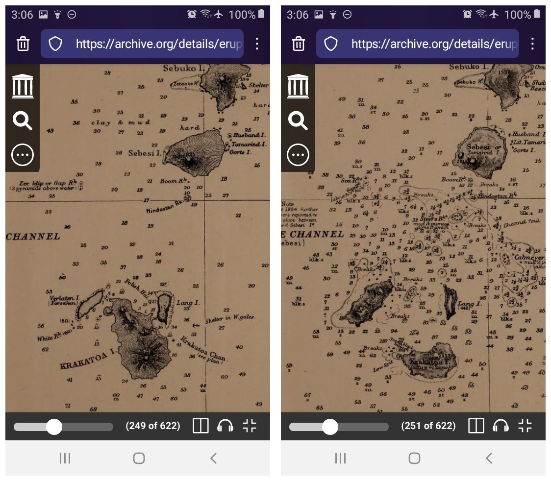
Screenshots of relevant parts of Plates XXII and XXIII in the Royal Society Krakatoa Committee report.
Somehow H. sapiens finds a way, even through something like the VEI 6 eruption of Krakatoa in a busy sea traffic lane, with heavily populated islands and coasts nearby.
Recovery
Starting on August 28, 1883 — after the northern two-thirds of Rakata/Krakatoa Island had blown itself to pieces out in the Sunda Strait on the 26th and 27th — life went on for survivors in eastern Sumatra and western Java.
Aid from colonial, local, and international sources poured in. The dead who could be found, tens of thousands of them, were buried or cremated. The missing were sought for — and sometimes found alive!
Physical injuries were treated, although scars of body and mind remained painful for many years afterward.
Material wreckage left by Krakatoa’s great waves and strait-crossing fiery ash clouds was cleaned up — a gargantuan task.
Colonized natives and their Dutch colonizers gradually resettled almost all of the coastlands.
(This brief reference to Indonesia’s rich but complex human history needs to be made because of the 1920s video of Anak Krakatau breaching the Sunda Strait that we’ll see later — that film was made during the colonial era.)
Parts of southwestern Java had been too heavily damaged to rebuild, particularly on the Ujung Kulon Peninsula, so they were abandoned and soon returned to their natural state.
Everything from wild cats to rhinoceroses and rare plants moved in (if they weren’t there already), and much of the area became parkland after Indonesia gained its independence.
The new setting
In its final agonies, Krakatoa had blasted out some 12 cubic kilometers (almost 3 cubic miles) of magma, converting it into thick, dense ash beds of the kind that geoscientists call ignimbrite. (Gianchetti et al.)
This layperson thinks of ignimbrites as pyroclastic flows on comic-book-character levels of steroid.
No one in the immediate neighborhood could survive that, including the hapless thousands just north of Krakatoa who called Sebesi Island home.
Deep beds of ignimbrite also covered the archipelago’s rocky remnants, as these screenshots from the Dutch Anak Krakatau film show:
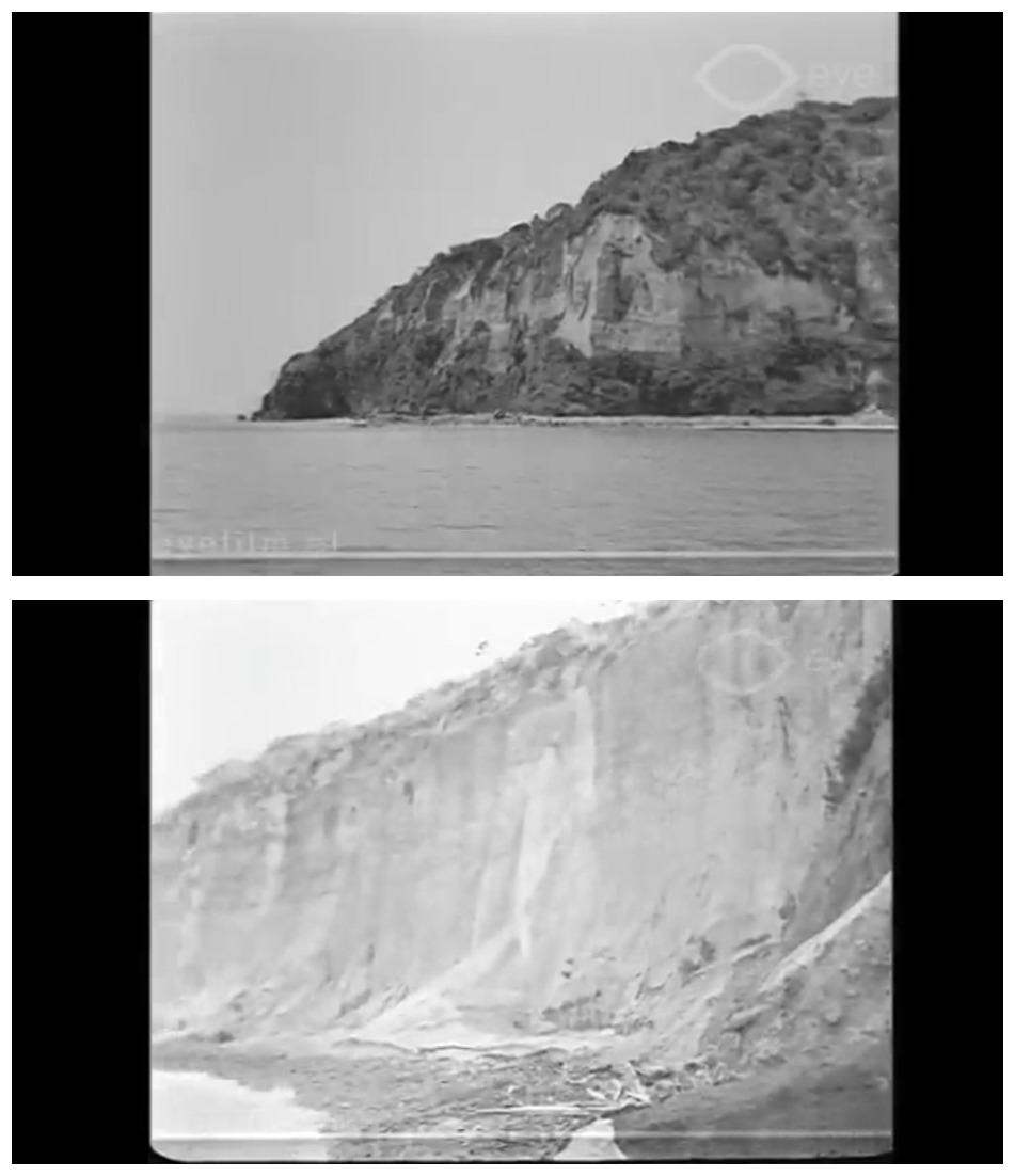
This is on Panjang (Lang), I believe. Sometimes the tropical vegetation — shown here less than fifty years after the eruption — was able to take root; sometimes not.
In the late 19th century, ignimbrite deposits that went into the waters around Krakatoa formed many new little islands and “sand” bars.
Most of these have since eroded away, but during post-eruption recovery, new maps of this vital shipping route were needed as soon as possible.
People charting the strait’s bathymetry came across some rocks from Danan — second tallest volcano on the old island, after Rakata:

Let’s keep the location of old Perboewatan in mind, too. (Image: Figures 2 and 3 from the Royal Society report).
These rocks stood about fifteen feet above sea level:
There they are, in the outside left image on the bottom row. (Image: Pratama et al., Figure 2, CC BY-SA NC 4.0)
The seafloor here is at least six hundred feet deep. (Winchester)
Instead of naming this hardcore formation of andesite pillars something along the lines of “Danan 2.0” or “Die Hard In A Volcano,” sensible Dutch cartographers wrote Bootsmanrots (Bosun’s Rocks) on the map and flagged them as a hazard.
Time passed.
The military vessels that had been posted at either end of the Strait to warn mariners of danger were assigned duties elsewhere.
Sensible local fishermen started to return to the productive Krakatoa Archipelago reefs about six months after the eruption. (Winchester).
Scientists sailed out to see what they might see. Data were collected; papers and books were published. This work continues today.
Other forms of life went out there, too — on strait currents, in a sea bird’s gullet, or riding the wind — including (Oppenheimer):
- A spider on the formerly heat-sterilized rock — just nine months after Krakatoa’s big blast!
- By 1896, fifty-three different kinds of plant!
- In 1908, two hundred animal species (mostly insects)!
In 1919, soundings revealed a new shoe-shaped but apparently nonvolcanic ridge in between the positions of the former Perboewatan and Danan volcanoes. (Winchester)
Fast-forward to today:
At this point in a horror movie, a supposedly dead villain would suddenly open their glowing red eyes.
And that’s pretty much how it went down in the newly empty stretch of water in between the islands of Rakata, Panjang (known to the Dutch as Lang), and Sertung (a/k/a Verlaten).
Winchester’s description of the event is movie-worthy, too:
…on the evening of June 29, 1927, a group of fishermen who were hauling up their nets after a day spent innocently trawling for wrasse and sweetlips, and trolling by line for grouper and skipjack, witnessed something entirely unexpected and wholly extraordinary. With a great roaring and rumbling sound, a clump of enormous gas bubbles suddenly broke the surface of the sea. The bubbles seemed to be all around, to be rising in strange and random combinations to port, to starboard, ahead, abaft.* It was very confusing, and very frightening. Exactly where under the sea these bubbles—which exploded in clouds of spray and ash and foul-smelling sulfurous gas—were coming from, and whether they were coming from one point or from many, was difficult to say. The panicky sailors, caught in the midst of them, seemed to think they were concentrated a point more or less above where Danan, the middle of the three former Krakatoa peaks, had once been…
*A concentration of escaping gas from the seabed can, in certain circumstances, create a zone of negative buoyancy, where passing ships are at risk of sinking. This happened in the 1970s when a seabed gas well in the North Sea fractured, and an inverted cone of small bubbles rose from it to form, at the surface, half a square mile that was more gas than water, and not at all buoyant. Moreover, the escaping gas was highly flammable, which nicely doubled the hazard.
Continuing with Winchester as a source, the fishermen neither sank nor burned, luckily, but they noticed that the water here was warm, too.
And at night now, everyone gathered along the shores to watch the glowing red water where Rakata/Krakatoa Island used to be.
🌋🌋🌋
The children of Krakatoa
Throughout the summer of 1927, scientific observers noted bands of froth, bubbles, and eventually steam plumes near the Bosun’s Rocks — by year’s end, this linear stretch of troubled water was a quarter-mile long.
Activity then increased and finally the new volcano broke through the strait surface on January 26, 1928. A Russian observer, per Winchester, named it Anak Krakatau — Child of Krakatoa.
And sensible Dutch geologists made a nonfiction silent movie (1920s, remember) about it that holds up surprisingly well today:
English subtitles. As an aside, the “Bantam” region they fly over was hit hard in 1883; the film makers are proudly showing off parts of what is now Banten Province that have recovered.
In addition to newborn Anak, I include the locals as children of Krakatoa.
Native people in that short silent film who are younger than their mid-40s were born after the great eruption, but they were born into families of Krakatoa survivors and know countless personal stories of horror and survival.
And, presumably, most of the middle-aged to elderly local people shown here saw that 1883 eruption with their own eyes and survived it in some way.
But they are just props to the foreign geologists who are making this documentary about “their” lucky break.
I can’t hate the young Dutch men for following an arrangement that had existed for centuries before them; they didn’t start it, they were conditioned to see it as normal, and they couldn’t know how the times would change.
In some ways I envy them for this opportunity to see the famous volcano come to life again (and, to be honest, for that biplane selfie, too!).

But they are oblivious to the walking library of oral histories around them that is quietly following orders, keeping its distance, waiting upon, waiting…
No one, as far as I know, ever recorded the stories of Krakatoa that the native people in this video (and other locals) might have shared with us all.
That’s a heavy loss, especially since Krakatoa — which we’ll call by its new name from now on — has refused to stay in the history books and is an active threat today.
Another “Big One” unlikely any time soon
As we can see in the Dutch film, at first the new volcano rose, collapsed, and rose again — just as Surtsey would do, off the coast of Iceland, four decades later.
This went on, over and over again, for years — sometimes the sea wins in these situations; sometimes the volcano manages to protect its vent from water and starts growing into a volcanic edifice.
Surtsey succeeded. So did Anak Krakatau, on August 11, 1930.
But Anak Krakatau’s growth rate is much faster than Surtsey’s and, unlike the Icelandic fire island, it has continued erupting almost constantly since it first broke the waves.
Of course, our first lay reaction to that news is — Aaagh! Another VEI 6 eruption!
Not so much. Certainly not in the twentieth century and, all things being equal, probably not in the foreseeable future.
Anak is industrious and can be quite explosive in its own way, but it is just SO small, in Krakatoa terms.
Submarine studies show that Anak Krakatau is basically just a “bump” on the northeast 1883 caldera rim.
As this layperson understands things, to get another “big one,” you’re gonna need a bigger magma chamber — say, one the size of the 1883 caldera.
Along the way to collecting another three-plus cubic miles of explosive magma in that chamber, another set of volcanoes perhaps will form and coalesce into an island similar to old Rakata/Krakatoa, too.
This cannot happen overnight. It all works on the geologic time scale.
Surprises can’t be ruled out — but surprises on the order of the 1883 catastrophe come with precursors of a size that would be detected by today’s monitoring.
Here’s a little more good news.
Since its birth in the 1920s, Anak Krakatau has always been a research magnet.
Around 1949, some volcanologists suggested that this complex volcano is “bimodal.”
In other words, for reasons that aren’t yet clear, its magma chemistry evolves over time from rather “runny” basalts that look pretty from a distance —
Weak strombolian activity, 2007.
— to a more “sticky” chemistry that gets more and more explosive over time.

1883. (Image: Wikipedia, CC BY-SA 4.0.
These days, according to Pratama et al. Anak Krakatau is probably in an incubation phase, with mafic (“runny”) products of frequent and small eruptions.
Vulcanian eruptions (one-off limited blasts) like this one in 2007 are impressive but not even close to what went on in 1883.
They note that Anak might evolve later on (i.e., turn into something along the lines of Danan or Rakata), but that remains to be seen.
“Incubation” is not the most reassuring word to us laypeople, but it does imply that the next Big One, if it comes, will happen far down the road.
So how has Anak Krakatau developed to date?
Anak Krakatau through 2017
According to Camus et al., Anak Krakatau had on-again, off-again eruptions from January 28, 1928, to February 28, 1929.
The result: a sickle-shaped island, nine hundred feet long and a little over a hundred feet above sea level.
There is at least one shot of it in the silent film.
Water and magma still came into contact now and then, particularly over the next thirty years.
As a result of this phreatomagmatic explosive activity, by 1959 Anak Krakatau had built a complete tuff ring, 500 feet tall at its highest point.
As well, it hosted a crater lake inside the ring.
In 1959 to 1960, a volcanic cone began to develop out of the lake, and this became the main vent.
(Camus et al. couldn’t know it at the time, but this conjunction of hardened tuff ring and new cinder cone would lead to tragedy in 2018.)
Over following decades Anak Krakatau continued growing by as much as sixteen and a half feet per year (Cooper) through occasional lava flows as well as with typical vulcanian and strombolian explosive eruptions.
A rather abrupt volcanic wake-up in 1981 caused a 6.6-foot tsunami on Rakata, and Camus et al. did warn that a powerful eruption or the development of a lava dome could trigger dangerous regional tsunamis (though not on an 1883 scale).
But Anak’s eruptions never got more intense than VEI 3, and that was seldom. Too, its geochemistry didn’t change, and so red lava ran down its flank rather than doming up in the crater.
By 2003, Winchester calculates, Anak Krakatau had averaged about twenty inches of new growth each month since 1927 and it was almost forty feet wider.
When two volcanologists were filmed on the volcano for this 2015 docudrama, Anak Krakatau was enormous!
2018
Volcanoes are changeful places, always thwarting efforts to understand and forecast their behavior.
For instance, their vents can migrate from place to place.
Anak Krakatau is no exception, with its summit vent moving slightly northward between 2008 and 2011, and then heading back south. (Hunt et al.)
Explosions or lava flows reshape a volcano’s surface in an instant. This, too, makes it difficult for volcanologists to predict what the fire mountain might do next.
Lava flows at Anak Krakatau, for example, began in 1960 and ocurred intermittently after that, particularly on the southwest flank. (Winchester)
And Anak Krakatau’s activity picked up in June 2018, rapidly increasing the structure’s area as well as adding an additional 54 million tons from tephra fall and lava flows to the load acting on its summit and southwest flank by late December. (Walter et al)
Volcanoes also sometimes collapse, for reasons that still are not well understood because such events usually go unseen.
Sector collapses — where the flank failure also removes the volcano’s summit — are complex, and there is no consensus among experts on their precursors, that is, how they build up and then fail. (Hunt et al.)
Well, you can see where this is going.
A landslide had occurred on the southwest flank of Anak Krakatau at some point between 1941 and 1950. (Hunt et al.)
It apparently was not large enough to divert attention away from ongoing major national crises — the struggle for independence, Japanese occupation during World War 2, and the end of Dutch control in 1949.
A sector collapse ocurred in the same area, controlled by the tuff ring-new cone interface, late in the evening of December 22, 2018, on a much larger Anak Krakatau.
It looked like this on the instruments —

Walter et al., Figure 4, CC BY-SA NC 4.0.
— and the resulting tsunami was like this in the words of a photographer who was out filming Anak’s heightened activity from a nearby coast.
It was at night, in cloudy weather, and unfortunately the tsunami was not detected by anyone until just before it hit them.
There were a lot of holiday party goers along those beaches.
British experts modeled the tsunami this way:
Surprisingly, Anak roared to life after the collapse with both explosive eruptions and intense Surtseyan activity.
For days Anak erupted violently, and its eruption plumes mingled with meteorological clouds to hide the scene from satellites. Ground views were obscured, too.
Hundreds were dead, thousands injured. What new nightmares might old Krakatoa have in store for the twenty-first century?
To be continued…
Featured image: Wikipedia, CC BY-SA 3.0
Sources:
Camus, G.; Gourgaud, A.; and Vincent, P. M. 1987. Petrologic evolution of Krakatau (Indonesia): implications for a future activity. Journal of Volcanology and Geothermal Research, 33(4): 299-316.
Cooper, M. 2010. Krakatau, Indonesia: a volcano with a history. In Volcano and Geothermal Tourism (pp. 200-201). Routledge.
Cutler, K. S.; Watt, S. F.; Cassidy, M.; Madden-Nadeau, A. L.; and others. 2022. Downward-propagating eruption following vent unloading implies no direct magmatic trigger for the 2018 lateral collapse of Anak Krakatau. Earth and Planetary Science Letters, 578: 117332.
Dahren, B.; Troll, V. R.; Andersson, U. B.; Chadwick, J. P.; and others. 2012. Magma plumbing beneath Anak Krakatau volcano, Indonesia: evidence for multiple magma storage regions. Contributions to Mineralogy and Petrology, 163: 631-651.
Gabrielson, T. 2010. Krakatoa and the Royal Society: the Krakatoa explosion of 1883. Acoustics Today, 6(2): 14-19.
Giachetti, T.; Paris, R.; Kelfoun, K.; and Ontowirjo, B. 2012. Tsunami hazard related to a flank collapse of Anak Krakatau Volcano, Sunda Strait, Indonesia. Geological Society, London, Special Publications, 361(1): 79-90.
Global Volcanism Program. 2024. Anak Krakatau. https://volcano.si.edu/volcano.cfm?vn=262000 Last accessed August 29, 2024.
Hunt, J. E.; Tappin, D. R.; Watt, S. F. L.; Susilohadi, S.; and others. 2021. Submarine landslide megablocks show half of Anak Krakatau island failed on December 22nd, 2018. Nature Communications, 12(1): 2827.
Madden-Nadeau, A. L.; Cassidy, M.; Pyle, D. M.; Mather, T. A.; and others. 2021. The magmatic and eruptive evolution of the 1883 caldera-forming eruption of Krakatau: Integrating field-to crystal-scale observations. Journal of Volcanology and Geothermal Research, 411: 107176.
Madden-Nadeau, A. L. 2021. Silicic caldera volcanism and the 1883 eruption of Krakatau Volcano, Indonesia (Doctoral dissertation, University of Oxford).
Oppenheimer, C. 2011. Table 2.2, in Eruptions That Shook the World. Cambridge: Cambridge University Press. Retrieved from https://play.google.com/store/books/details?id=qW1UNwhuhnUC
Pratama, A.; Nurfiani, D.; Suryanata, P. B.; Ismail, T.; and others. 2023. Magma storage conditions beneath Krakatau, Indonesia: insight from geochemistry and rock magnetism studies. Frontiers in Earth Science, 11: 1128798.
Walter, T. R.; Haghshenas Haghighi, M.; Schneider, F. M.; Coppola, D.; and others. 2019. Complex hazard cascade culminating in the Anak Krakatau sector collapse. Nature Communications, 10(1): 4339.
Wikipedia. 2024. Anak Krakatoa. https://en.m.wikipedia.org/wiki/Anak_Krakatoa Last accessed August 28, 2024.
___. 2024. 2018 Sunda Strait tsunami. https://en.m.wikipedia.org/wiki/2018_Sunda_Strait_tsunami Last accessed August 29, 2024.
Winchester, S. 2004. Krakatoa: The day the world exploded. Penguin UK. Retrieved from https://play.google.com/store/books/details?id=QjFjCGpuIacC
Yokoyama, I. 1981. A geophysical interpretation of the 1883 Krakatau eruption. Journal of Volcanology and Geothermal Research, 9(4), 359-378.
