Iceland’s Recent Fires — September 7, 2024 (2009 UTC)
That feature image above shows the Vogar cam view of the Keflavik-Reykjavik road on August 23, 2024, around 2230 UTC, with traffic on it. The fountains are five miles or more away, and Iceland’s volcanologists say that these fissure eruptions do not threaten any infrastructure right now.
A 360° drone view of the Sundhnuks, Grindavik, and Svartsengi area on August 7, 2024, with labels.
September 7, 2024, 1:09 p.m., Pacific: IMO called the eruption yesterday (via Google Translate):
September 6 at 9:30am
• No visible activity in the craters for about half a day
• The last signs of volcanic unrest were seen yesterday afternoon
• The eruption lasted for about 14 days
• Landris has started again in Svartsengi
• Risk assessment will be updated later today
The eruption north of Stóra-Scógfell is over. The eruption lasted for about 14 days.
This was the third longest eruption of the six that have occurred in the Sundhnúks crater series since December 2023. The eruption that began in mid-March lasted for about 54 days, and the eruption that began at the end of May lasted for about 24 days.
…
Landris is measured in Svartsengi and magma has therefore begun to flow into the magma chamber again. It is too early to state the rate of magma accretion, but initial model calculations suggest that it is similar to before.
They also note that this was the largest flow in the series that began in December 2023, although weather conditions have prevented them from getting measurements for a specific volume/area estimate.
So now the waiting begins again…
September 5, 2024, 7:32 a.m., Pacific: Update from IMO today, via Google Translate:
Evidence that landris has started again in Svartsengi
Reduce the power of the eruption somewhat
5.9.2024
Updated September 5 at 1:40 p.m
• Further reduces the power of the eruption
• Evidence that landris is starting again in Svartsengi
• Southwesterly direction at the eruption stations, 13-20 m/s. Air pollution could be noticed in Vatnsleysa and in the capital area.
• Risk assessment largely unchanged
The activity of the volcano continues to decrease in the last few days. But still two gosop seem to be active. The lava bed north of the crater continues to expand at a slow rate to the north, also thickening at the same time. At the moment, lava flows do not threaten infrastructure in the vicinity of the eruptions. Measurements of eruptive turbulence and gas emissions from the eruption also indicate that the eruption has subsided somewhat in the last few days.
A map showing the active part of the lava bed that has formed in this eruption. The map is based on data from the Iceye satellite.
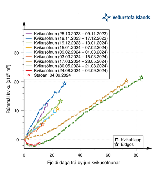
GPS measurements show evidence that landrising has started again in Svartsengi. At the same time, the flow from the volcanic eruption on the Sundhnúks crater series has decreased. It indicates that the inflow into the magma accumulation area under Svartsengi is greater than the flow from the eruption on the surface. The trend is similar to that after the last eruption started on May 29. Landris in Svartsengi started to become detectable about two weeks after the eruption began.
The graph shows the estimated amount of magma that has been added under Svartsengi between the eruptions or magma flows that have occurred since November 2023. The green line shows the trend of magma accumulation between the last two eruptions. The red line shows the evolution of magma accumulation after the start of the current eruption, which shows a very similar curve to the green one.
The weather forecast for the day (Thursday) is a south-westerly direction at the eruption centers, 13-20 m/s and a little rain or mist in the beginning of the day, but then 10-15 m/s. Pollution from the volcanic eruption reaches the north and northeast and could be felt in Vatnsleysa and in the capital area.
Seismic activity has slowed since the eruption began on August 22. In the last few days, the activity has decreased even more, and very little seismic activity has been observed in the last few days. Gusty winds may, however, have some effect on the sensitivity of the seismic system to detect even the smallest tremors.
Risk assessment is largely unchanged, except that risking due to eruptions is rated lower now. The card remains valid until September 10.
This layperson thinks it’s a good sign that the eruption is tapering off, not seeming to be extinguished like a candle, which is how the end of the last Sundnukhs-area eruption appeared to me.
Hopefully, that region close to Grindavik and the power plant will not reactivate in future cycles (should they occur, which seems likely enough at the moment).
But it also seems to this layperson that at least two levels of the peninsula are involved in these plate boundary deformation zone shenanigans:
Close to the surface, pressure fields are a major factor
At depth are factors, seemingly independent of those shallow pressure fields, that bring magma into the sill centered several miles below the Thorbjorn/power plant area of Svartsengi
It’s a complex picture even without considering the reservoir under Fagradalsfjall suggested by a recent study, or the petrological analysis on current eruption products that suggests peninsula volcanism is now in equilibrium.
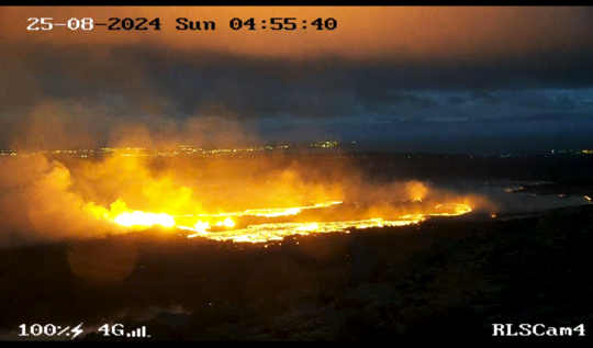
The volcano in the last 24 hours has offered a very impressive spectacle. Now that it’s been four days since the eruption of the eruption, it’s unusually powerful compared to previous events. What characterizes the activity now are stable and high mercury strokes. Earlier eruptions have produced similar large cylinders, but they have usually been pulsating rather than stable. The boys are tens of meters high and can be seen from many places, including Akranes. Could this be an indication that the fire that comes up there at the Sundhnúkasprungun is more gas-rich than before. These stable boys are clearly visible in the following video that drone pilot karsak Finnbogason https://www.youtube. com/@IcelandFPV shot tonight where he streamed live from the reefs. Isaac is still live as this is written and you can follow the stream here https://www.youtube. com/watch?v=YnJZE_VA3Ug
Isak’s August 26 footage:
Magnus Tumi told mbl.is yesterday that right now the lava doesn’t threaten the Keflavik Road (Reykjanesbraut). Other authorities quoted in mbl.is articles say that they are watching it closely and do have plans for a barrier, should the situation call for it.
Such relatively casual talk about a lava diversion barrier would have been unthinkable anywhere prior to last November!
August 25, 2024, 6:56 a.m., Pacific: This is so great! Even the IMO update sounds a little perky, though it is, of course, objective and scientifically detailed.
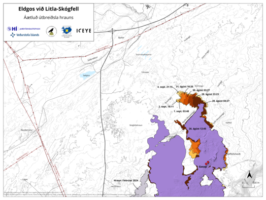
First, in simple terms and using an image from IMO’s August 23rd update (caption via Google Translate), only the two short red lines in the upper right are erupting —
“A map showing the extent of the lava (dashed area) produced in this eruption and the location of the fissure (red line) as it was at 03:39 this night. Also shown are the lava beds that have formed in the area since December 2023 (Purple Covers). The map is based on data from the IcEYE satellite.”
— all the purple and gray area, erupted since December 18th, is quiet now and the flow field from this eruption’s initial stages is starting to cool without its western lobe having even reached the road. 👏🙂
Grindavik and the power plant are spared.
The fissures that are active — those two red lines up there — do not threaten anything right now; that area is close enough to the Keflavik Road and Reykjavik to be “touristy” (and the authorities have obligingly lowered the speed limit so people can park off to the side and watch, which most are doing peacably enough); and this eruption now seems to be settling down and building a cone, which [layperson opinion] could mean a shift northward for the whole eruptive process out into an uninhabited area! [/layperson opinion]
Time will tell about that.
Here is the IMO update (via GT):
Updated August 25 at 8:50 am
The activity of the eruption is constant
Still erupting in two places
The rims of the crater are starting to pile up
Low seismicity in the area
Important to monitor the gas distribution forecast
The activity of the volcano has been quite stable during the night. It is still erupting in two places northeast of Stóra-Skógfell. Judging by the webcams, crater rims are starting to load up.
Lava flows mostly to the north, but there is also a small lava flow to the west. The advance of the lava is slow. The lava tongue that originally flowed west towards Grindavíkurvegi between Sýlingarfell and Stóra-Scógfell seems to have started to cool and no movement there is visible on webcams.
Seismic activity is quite low in the area and mainly confined to the part of the area where the eruption occurs. One earthquake of M2.2 was at the eruption centers around 2 am.
A screenshot from the surveillance camera of the National Security Service on Fagradalsfjall that shows the activity around five o’clock this morning.
Addendum, 1451 UTC: The north wind finally died down and this shows on the Vogar cam:
August 24, 2024, 12:52 p.m., Pacific: There is fountaining again on the Vogastapi and Vogar Live From Iceland webcams.
Let’s see if their mosaic of live cams will embed — nope. Here is the link (note the vagri.is graphic in the lower right).
I’m not rigorously following this today and am working on something else but noticed the fountains when I checked just now. Either I missed them in the thick gas clouds or they restarted.
In any event, per the vafri.is graphic there was a M1.25 in the Keilir area of Fagradalsfjall at 1456 UTC (which is also Iceland time) followed by two 1-pointers in the Svartsengi area south of Vogar at 1513 (M1.23) and 1555 (M1.08); this is the northern fissure area, I think.
Interesting but I really don’t if or how it might all tie together.
August 24, 2024, 10:56 a.m., Pacific: No reported changes in activity, but I just learned that Isak Finnbogason is live.
This screenshot of the ongoing activity is from ~17:47 of that video:
The Southern Volcanoes experts note
(Facebook translation):
The fountain activity is now tied to two areas of the fountain crack. The activity is all northeast of Stóra Skógfell and therefore the main weight of this volcanic eruption is to occur much north than has been seen before in the current eruption at Sundhnúki. The lava crawls steadily forward and has now surrounded Little Skógfell. There is the lava eater about 4 km from Reykjanesbraut. The lava slowly moves north and northeast from the slope. The volcano seems to have balanced last night and has been constant for the last 24 hours. Is the lava drainage probably below 100 m3/sec, but when it was the lowest it was thought to have been close to 2000 m3/sec.
Translated from Icelandic
Eldfjalla- og náttúruvárhópur Suðurlands
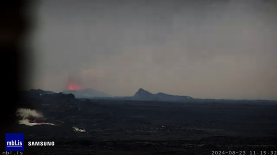
August 24, 2024, 4:57 a.m., Pacific: In terms of volcanism, there is nothing much to see on the live cams (mbl.is, RUV, and Live From Iceland) except clouds of gas.
I think some fountaining might still be going on just north of Skogfell because the clouds are reddish there but no lava shows up on the monitor.
This might be a new development since media interviews published just a few hours ago include descriptions of strong fountains.
They were certainly going strong, north of Skogfell, when I went to bed last night.
[Layperson speculation]The fissure eruptions south of Skogfell went out very quickly after the new fissures opened — whiffed out, so to speak, just as the May 29 eruption crater seemed to be.
It really was amazing to watch the fountains south of Skogfell dwindle in real time as the northern ones increased.
I don’t know that one sees that in a purely magma-driven eruption; fluid pressure drops gradually as the magma runs out.
To this layperson, it speaks of tectonic forces (more or less horizontal) driving these fissure eruptions in addition to magmatic pressure rising up from below.
It could be. In Iceland, I understand, plate boundaries are more like broad zones of deformation than lines of fractures between two tectonic plates.
And now the new eruptive fissures north of Skogfell are behaving like the older ones south of that landmark did at first, with the eruption dying out surprisingly quickly after that initial breakthrough.
Will the same pattern continue (cycling rather predictably a few times, then extending intervals between eruptions north of Skogfell while prolonging the eruptions more and more)?
Who can say?
My opinion is scientifically baseless and so doesn’t matter at all, but I do think that we well might be seeing field confirmation of one hypothesis about why the Reykjanes Peninsula goes 800-1,000 years between eruptions: the mid-ocean ridge here, either naturally or as a result of interactions with the mantle hotspot — or for both reasons — intermittently but rather regularly goes through periods of expansive (Peninsula volcanism) and compressive (no volcanism but stronger earthquakes) overall stress field conditions.
Why? Let’s cross that bridge after they reach a consensus on this hypothesis.
The peculiar combination of pressures that we’re seeing today could be a result of the transition between these two dominant ridge regimes. Only a layperson could make such a silly suggestion :), and I’ll go even further and make a prediction: as these eruptions continue, the lava-producing events will gradually become longer and more productive as the compressive tectonic forces give way to the expansive ridge regime for a while.
Then there will come the somewhat more voluminous eruptions like those now observable in the geologic record of all other Peninsula volcanic systems (however you choose to define them) except this Fagradalsfjall and Svartsengi area.
That is, nothing over the top will occur but more lava will erupt than has been seen here in historical times — the same old story, in geologic perspective.
After the Fagradalsfjall-Svartsengi area has “met its quota,” other systems would then go off, as they have done in the past, or things might quiet down for another eight centuries or so, depending on where this part of the Reykjanes Ridge is at in its overall expansion-compression cycle.[/layperson speculation]
Ah, it’s nice to be a layperson and just babble away without having to provide proof — or at least a careful and meticulously reasoned out argument!
How difficult to explain and predict this all must be for volcanologists and others who are responsible for the wellbeing of Iceland and its people.
August 23, 2024, 4:05 p.m., Pacific: I was planning to switch between live blogging here and following the eruption discussion at TalkWeather, but things got intense at the power plant and I just watched, followed medand IMO updates, and stayed where I was at TW (all the following images are screenshots from last night) —
That’s the power plant, lower left. Reykjavik is in the far distance. Those blue things are drones, based on how they moved without regard for topography. It was bustling there along the barriers, for obvious reasons. I thought, “Icelanders behind UFOs — who would have guessed?” But I wondered where that second flow in the distance came from.
Then whoever was controlling that cam turned it back toward the curtains of fire —
It’s a little hard to see there, but new fissures had opened just north (left) of the erupting vents, and those fountains were bigger than those to the south.
In fact, the line of fountains from eruptions previously in the day dwindled in height, even as I watched. We were just in time to see a little northward extension of the new line but then it stopped.
The fountains there were impressive but most of the action was hard to see, what with the cams on and around Thorbjorn being so far away.
To make a long story short (details are at the IMO updates and media links at the top of the page), overnight the new line did extend again, opening another 2 km to the north in two hours, while the southern line died out completely and it stays out as of now.
The lava threatening the power plant stopped several hundred meters from the road soon after the first fissure line went dark.
In media reports, authorities and plant personnel in the Grindavik and Svartsengi area are expressing delight.
IMO has reduced the risk in Grindavik to Orange. Blue Lagoon — the world’s most hard-core thermal spa by now — opens again soon.
It’s been a long time for the people of that area since November 10, 2023. ❤😎
The new fissure fountains remain active and are visible from the Keflavik Road -‘
— but the lava reportedly is flowing northeast, which is uninhabited country. There are wildfires, which was also an issue with the Litli-Hrutur eruption at Fagradalsfjall last year.
A look at the vafri.is earthquake graphic linked at top of page tells this layperson that M1 to M2 seismicity in the area has gone back to background occasional microquakes at the moment, anyway, though there was a 3-pointer at Keilir (near Litli-Hrutur) last night.
Overall, IMO says, the eruption seems to have stabilized.
I wonder if a new crater will emerge north of the old one that was constructed earlier this year.
The view from the Hagafell cam was murky, but that is the older crater rim showing in the foreground and a fountain from the new line behind Skogfell hill. This was early on in events; some activity back there continues tonight, per the Hagafell cam close-up (mbl.is).
IMO:
An eruption has begun on the Sundhnúks crater series-22.8.2024
Updated August 22 at 21:25
At 20:48, an intense series of small earthquakes began in the Sundhnúks crater series between Stóra-Skógfell and Sýlingarfell.
Increased pressure in boreholes has also been observed. These are clear signs that a magma flow has started and that a volcanic eruption is likely to start as a result.
The news will be updated as information is received.