
Cam perspective; click links to visit cam:
Afstöðumynd af svæðinu, gossprungan merkt inn á ásamt vefmyndavélum.
<https://t.co/dZSOHvj9dL> Húsafell
<https://t.co/QAOpCJRWdj> Sýlingarfell #1
<https://t.co/gq80DPFK9t> Sýlingarfell #2 pic.twitter.com/lFXVm6FgxZ— Birkir (@birkirh) December 19, 2023
https://platform.twitter.com/widgets.js
- Icelandic Met Office, (autotranslated).
- IMO geoscientist notes, (autotranslated).
- London VAAC
- RUV (autotranslated front page; they frequently change live update link, so look for red box with white dots flashing and please be aware that autotranslation might not carry over when you click it; I use either browser translation or Google Translate online).
- MBL.is topic page (autotranslated).
- Visir.is front page (autotranslated)
- Jón Frimann’s blog.
- My earlier blogging to date of eruption and also post through November 7th.
January 13, 2024, 10:24 p.m., Pacific: RUV reports that magma is underneath Grindavik now, though I see no news of explosions — it must be in a crack below the water level and its floor.
Hope it stays down there! It might go out into the portion of the dike that is under the sea. If it comes up, I hope that it does so way out beyond that beautiful harbor.
Get this! Mount Thorbjorn has moved west — 20 cm at last report. A scientist told RUV that it was 15 cm when they went into a meeting and 20 cm when they checked again!
The mbl.is cam on Thorbjorn appears to be online so far.
There have been no other informed comments on that, but this layperson suspects that a rifting event is underway and the portion of Eurasia [See below] that Thorbjorn occupies has moved west relative to the boundary with North America out there on the Svartsengi Plain.
[CORRECTION: Should have double-checked my source before writing that: “…IMO reported possible magma accumulation beneath Reykjanes, centered along the plate boundary below the Svartsengi fissure system, just W of Thorbjorn.” So, Thorbjorn is on North America, apparently. I have no idea why it moved west, but the boffins will figure it out.]
This is not unusual in Iceland — rifting and magma intrusion are how a mid-ocean ridge work.
Back in 2014-2015, with the Holuhraun eruption, the two plates moved 2 m apart in central Iceland!
Real spreading ridge processes are a lot messier than the models shown about Iceland.
January 13, 2024, 9:07 a.m., Pacific: IMO update:
Updated on January 14, at 05:00
Just before At 3 in the night, an intense series of small earthquakes began at Sunhnúksgíga. Up to 200 earthquakes have been measured in the area and the activity has moved towards Grindavík. Both borehole pressure measurements (from HS Orku) and real-time GPS stations in the area also show changes, so it is likely that a magma flow is taking place. Interpretation of this data suggests that an eruption is imminent. A lava eruption is the most likely scenario.
There is more than 40 feet of water in cracks under Grindavik; explosive magma-water interactions might occur, this layperson suspects.
January 13, 2024, 8:33 a.m., Pacific: RUV reported (autotranslated) last evening that seismic activity increased at the “magma tunnel.” MBL.IS has just reported (autotranslated) that Grindavik evacuation was called at 4 a.m.
At last check there was no new update on the IMO website, but of course they’re getting as much data as possible and assessing it to develop the most helpful update.
Here is the current quake view zoomed in on the Grindavik area.
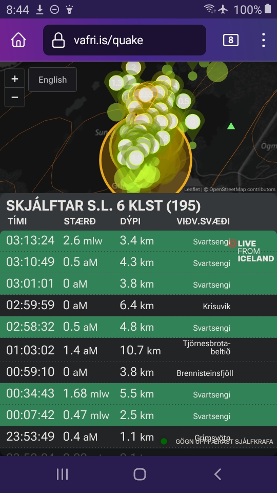
Three more came in while I was taking the screenshot. It’a pretty clear that magma is opening a path. The question is whether it will reach the surface — and where?
January 8, 2024, 1:25 p.m., Pacific: Seismicity is fairly quiet in the area, just as it was before the November dike formation and the December eruption.
The Svartsengi ground inflation had slowed — which has preceded activity in the past — but only briefly and now it is inflating again. A volcanologist told mbl.is (autotranslated) that he would like to see an InSAR image; satellite coverage will happen, but clouds may obscure the view.
Meanwhile, work on the Grindavik barrier continues (autotranslated).
While working on a project over the weekend — more about that in a coming writing update — I learned that the North America/Eurasia plate boundary goes right down the middle of Svatsengi plain, though it’s not visible on the surface. [See correction note under January 13, 10:24 p.m.]
That certainly explains the big sill three miles down. And now I see a little better just how unique this situation’s contributing factors are.
December 29, 2023, 9:30 p.m., Pacific: Here is today’s updated IMO assessment (over the span of this crisis to date, these IMO website updates, while never lessening in scientific rigor, have taken on a peer-to-peer sense, I think; it has much less of a “Academia to populace” feeling; it’s not surprising — everyone is in the same boat trip through troubled waters, and knows it):
Icelandic Meteorological Office
Note Land continues to rise at Svartsengi. Increased chance of eruption.
…
Risk assessment card valid until January 5
Increased chance of eruption
Land at Svartsengi has now reached a similar height as was measured just before the eruption on December 1829.12.2023
Updated December 29 at 2:30 p.m
Land continues to rise at Svartsengi. At the GPS station in Svartsengi (SENG), land has now reached a similar height as was measured just before the eruption on December 18. The rate of the land giant since December 18 has remained fairly constant, which is different from the situation before the last eruption, when the land giant slowed down in the weeks before the eruption. However, it is difficult to say that landrising slows down in the run-up to the next eruption, but this has been the case in eruptions that have occurred on the Reykjanes Peninsula in recent years and was also used as a reference in the Kraflu fires. However, there is uncertainty about how much magma pressure has to build up before magma starts to reach the surface.
The land giant now is not accompanied by as much seismic activity as before. The reason for this is that in the events of November 10 and December 18, great tension was released in the region when magma made its way through the earth’s crust. In the run-up to the last eruption, there were quite a few earthquakes over 3 and one over 4 in magnitude. With the continued earthquake, seismic activity is likely to increase again.
While the accumulation of magma continues under Svartsengi, there is a chance of another magma flow and that it will lead to an eruption. The odds are increasing with each passing day. It is most likely to erupt again on the Sundhnúks crater series, between Stóra-Skógfell and Hagafell. It is important to remember that magma flow does not always end in an eruption, as is the case with the activity at Fagradalsfjall and the Kraflu fires.
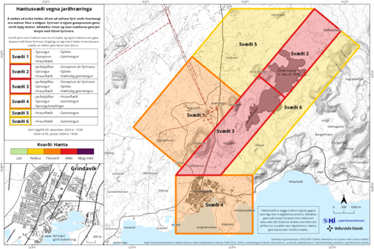
The Norwegian Meteorological Agency has published an updated risk assessment map based on the combined interpretation of data at a scientific consultation meeting held this morning. The assessment of the danger level within the areas is unchanged from the last time. However, a change has been made to the dangers that are possible within zone 4, Grindavík. There have been added dangers due to possible lava flow and gas contamination. The reason for the changes is the increased probability of a volcanic eruption north of Grindavík. However, those changes do not affect the overall assessment of the danger level of the area. This risk assessment card is valid until January 5, without any changes.
It is important to emphasize that the last eruption started with very short notice. The Norwegian Meteorological Agency continues to monitor the area carefully around the clock and is in direct contact with civil defense about the situation.
Over the next few days, the National Weather Service’s Solstice Watch will update the expert’s comment daily and more often if needed.
See link up above for autotranslated geoscientist’s comment.
December 26, 8:53 p.m., Pacific: There really is no news, but apparently the eruptive fissure degassing that Jón Frimann described on the 22nd is still going on because mbl.is reports (autotranslated) that sulfur emissions are affecting a nearby town.
The IMO geoscientist website note says that, barring any new events, their next scheduled update will be on the 27th.
December 23, 2023, 11:42 a.m., Pacific: Thus far, reportedly, Grindavik has an empty feel to it still, even though they are letting people in.
That might have to do with inclement weather and hazardous driving conditions — a major factor to consider when deciding to visit a place in such a risky situation.
IMO included the weather forecast in this update (autotranslated).
Also, they note:
…Land immediately began to rise again at Svartsengi after the eruption began on Monday evening, December 18. The speed of the land giant is higher than for an eruption. This means magma accumulation continues under Svartsengi, and is likely to lead to another magma flow and possible eruption. The most likely source area for an eruption is between Stóra-Skógsfell and Hagafell. The land curve as measured from the magma run on November 10 until the eruption began on December 18 was characterized by a slowly decreasing land sign, where eruption began when the land rate had significantly decreased. This process is very likely to repeat itself, and it can be expected that the next magma run can start with little notice when the land speed slows down again. The probability of an eruption therefore increases with each passing day…
December 21, 2023, 6:39 p.m., Pacific: Early this morning (Pacific time), I saw news that the eruption has stopped, at least in terms of visible activity.
Of course, everyone is happy — and I hope it is done with and the interval toward the next crisis is a long one — but I wanted to give it more time before blogging about it.
The current IMO update on their page sums up things nicely (via Google Translate, emphasis added):
Updated December 21 at 12:20 p.m
As stated in this morning’s update, it appears that the craters of the Sundhnúks crater have been extinguished, but it is not excluded that the lava flow is still in closed channels. Seismic activity has continued to decrease, and in the last 24 hours, around 70 small earthquakes have been recorded over magma passages. The largest earthquake measured 1.4 at 14:27 yesterday, and the largest earthquake since midnight is 1.9. Deformation measurements in Svartsengi show little movement, but measurements obtained in the next few days will better clarify the situation there.
Gas dispersion, mainly due to the degassing of the lava bed, will go to the southeast and out to sea today. Tomorrow will be a slower north-easterly and then the gas will go to the south-west.
At the moment it is difficult to say what will happen next, but the Norwegian Meteorological Agency’s scientists are constantly evaluating the latest data and the area continues to be closely monitored.
Also of note is Jón Frimann’s update today and his comments about seismicity and degassing.
Too, a variety of online news sources, including RUV (autotranslated) note that magma is accumulating again under Svartsengi.
December 20, 11:39 p.m., Pacific: Just a seismicity update. There is some per RUV:
Almost twenty tremors since midnight
The situation at the volcanoes at Sundhnúk is the same as last night, says a natural disaster expert at the Icelandic Meteorological Office. The meteorologist’s experts keep a close eye on web cameras, seismometers and deformation measurements.
Seismic activity has been low during the night and measurements do not show decisive changes in deformation. Almost twenty earthquakes have been recorded in the magma tunnel since midnight, the largest of which was 1.9 in magnitude and was measured at the southern end of the magma tunnel.
Yesterday, a total of 65 earthquakes were recorded and none of them were over 2 in magnitude…
And the magma findings reportedly (autotranslated) are making some geoscientists rethink their view of the peninsula (and, hence, of how mid-ocean ridges operate)!
December 20, 2023, 6:57 p.m., Pacific: Gosh, this is complicated!
The situation on the eruptive field at the moment is easily summarized: only two vents near the center of the magma tunnel (I like that term) are erupting, and that is steady, at a very reduced rate of around 10 m3/second.
But…
I can’t get into all the rest of it. Read the current (December 20 1800) IMO update (autotranslated) and Jón Frimann’s update today.
The current live RUV feed (autotranslated) has lots of news, too.
I haven’t even checked mbl.is and Visir yet tonight.
Instead, I wanted to get my thoughts in order first, and blogging them is a good way to do that. Here goes:
- This morning (before 7 a.m. Pacific), I read in mbl.is that two volcanologists were publicly criticizing the evacuation status at Grindavik.
This surprised me, not only because of breaking the “speak with one voice” best-practices approach I’ve read about in articles about volcano crisis management but also because there is an ongoing eruption less than 2 miles north of town — in the same fissure system that opened up underneath Grindavik in November.
Granted, the lava is not heading towards town at the moment. Still, when that began so suddenly and with little warning, one of my first thoughts was of the repeated statements from IMO in October and early November describing the pattern of earlier eruptions happening after a relatively aseismic interval.
That is exactly what happened in the lead-up to the December 18 eruption. Since there had been news of civil disobedience earlier that day — somebody staying overnight in town — I figured the eruption that night (plus the closing of that controversial Blue Lagoon planned opening) would change everyone’s thinking.
Apparently not. One volcanologist in this morning’s story said he didn’t think Grindavik should stay closed.
The other was quoted as saying he didn’t believe there was magma in the fissures under Grindavik. Though just a layperson, I am sympathetic with this view because of lack of toxic SO2 emissions from a source just a few thousand feet down that should have kept everyone out of the area, if I understand this volcanic gases concept right, and certainly should have prevented all the crack repair and other infrastructure work in Grindavik that was ongoing until the evac was called on the 18th because of eruption.
I’ve never before seen volcanologists publicly quoted saying such things about an area so close to an ongoing eruption — and, frankly, never thought anyone would see it.
There must be more to it than this, something going on in the background, as well as the nearness of winter holidays and all the difficulties and private/national expense associated with an entire town still in evacuation.
But, people, the eruption is going on, and per the latest updates (Frimann’s in particular), Svartsengi is still inflated rather than deflating to compensate for the outgoing flow, which was huge at first.
It’s a very difficult situation all around; I just hope the totally natural concern over the Grindvikings’ situation isn’t too distracting for everybody.
Of note, IMO issued a new hazard assessment downgrading the Grindavik sector — a little. Starting tomorrow, I think, residents will again be allowed in during the day.
- Next, news of the geochemical analysis of this erupting lava totally blew my mind.
Per the RUV update (via Google Translate) seven hours ago:
The magma that erupted in and around Sundhnúksgíga on Monday evening is of the same strain as the magma that erupted in the last three eruptions on the Reykjaness Peninsula.
The Earth Sciences Institute of the University of Iceland collected lava samples on the night of December 19. The results of their measurements indicate that:
• The magma stayed longer in the earth’s crust on its way to the surface than the magma in other recent eruptions in Fagradalsfjall.
• The magma has a different origin than the 2400-year-old Sundhnúk crater.I’m no expert (petrology was my nemesis in undergrad studies back in the 1980s), but this sounds important. The Fagradalsfjall system magma apparently has jumped into the Svartsengi system? From some reading, I know this does happen between Reykjanes volcanic systems sometimes, but it’s rare, I think.
Also, if it stayed down there for a while, what else might be going on at depth?
- Next, there has been interesting activity on the Mid-Atlantic Ridge just south of Iceland a few tens of miles — nothing unexpected but an uptick.
I just wanted to mention that in case it becomes relevant in the future. Given that there are tectonic things reportedly going on, as well as volcanism, it might matter at some point.
As of about an hour ago, the earthquake viewer shows this:
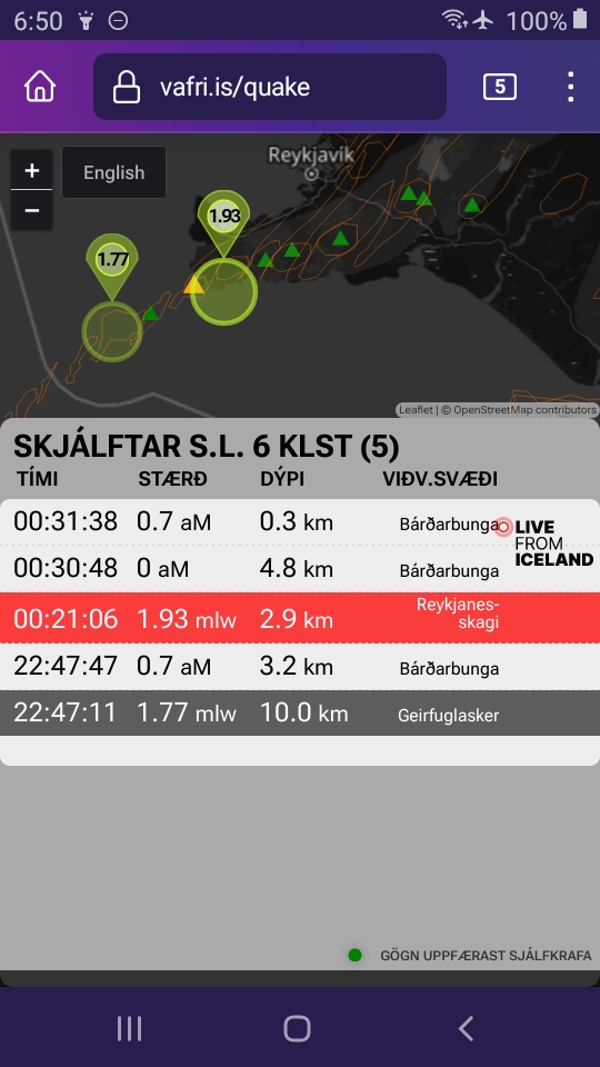
Those two large circles are still low-magnitude events and they are in areas that had triggered quakes when the local stress field was high before November 10th.
What fascinates me instead is the lack of any events at the eruption site/Grindavik area.
If I were a resident thinking of going in there tomorrow, I’d check the weather right now.
If it is bad, then probably the lack of registered quakes is just weather messing up the instruments.
If the night is clear, wind speeds are low, and Atlantic waves are not pounding the Grindavik coastline, I might hold off my visit and wait for more word from IMO and emergency officials, given what such quiet spells have occasionally led to in this part of the peninsula.
December 19, 2023, 10:19 p.m., Pacific: Here is one of the lava flow models. Per Twitter translation, “The Icelandic authorities have produced a model to understand how the flows will advance in the coming days with an initial emission rate of 300 m³/s which stabilizes at 30 m³/s. And well, it seems that at least until Christmas they shouldn’t be touching #Grindavík or the Blue Lagoon!”
P.s. Ovviamente il pericolo rimane perché lungo il dicco si potrebbero aprire altre fratture eruttive in qualsiasi punto (Grindavík compresa) e in qualsiasi momento. P.P.S. Inoltre, fortunatamente, sembra che il tasso di emissione di lava sia già inferiore ai 30 m³/s. pic.twitter.com/XhZPbbk992
— Il Mondo dei Terremoti (@mondoterremoti) December 19, 2023
https://platform.twitter.com/widgets.js
At 1830 on the 19th, IMO reported a flow rate about a quarter of what it was at the start, so 25 to 50 m3/second, then.
December 19, 6:10 p.m., Pacific: Dr. Páll Einarsson told mbl.is (autotranslated) that this eruption seems to be following the same pattern that Krafla’s did in the 1980s.
I’ve been reading up on those at Krafla’s GVP page and better understand what Iceland’s volcanologists meant when they said that this is going to happen over and over again into the foreseeable future.
Sigh.
December 19, 4:47 p.m., Pacific: On cams, the flows have decreased a lot but, unfortunately, the important activity is going on far underground, beyond the reach of monitoring instruments.
Svartsengi plain, per IMO, has subsided a bit. This is expected. They say that there is no way yet to tell whether this trend will reverse and more magma will come in.
Reportedly (autotranslated):
Hard to say what will happen next
When asked about the evolution of the eruption, she says it is too early to tell.
“This is the most difficult question we get,” says Kristín.
“We can say that it is good news that it has reduced so quickly, but how long will this continue?” Whether this is emptying from this magma chamber under Svartsengi or whether a pipe is forming as happened in Fagradalsfjall so that magma flows up from a great depth. We don’t know this now and it will become clear as time goes on how the magma flow decreases,” Kristín concludes.
[Layperson speculation] These issues go back to Iceland being a part of a mid-ocean ridge (and the hotspot, but let’s ignore that feature, which is centered farther to the east, for now).
The pipe she mentions is the dike, or feeder conduit, coming up from lower reservoirs, and it can go deep.
Yes, all the way to the mantle. The chemical signature of some lava in, I think, the first of these fires, at Geldingadalir, was reportedly from the mantle (which got volcanologists all around the world excited).
Of course, a lot of geophysical and geochemical things happen on its way up, and only a very little bit, if any, reaches the surface (hence the boffins’ excitement).
The thing is, Geldingadalir lava did show that this is possible in the Fagradalsfjall system so one must be mindful — basically — of human limitations in dealing with an Earth process and just try to be prepared for whatever the planet decides to throw at H. sapiens next through this window that it has opened up a little after an eight-century closure.[/Layperson speculation ]
December 19, 2023, 4:29 a.m., Pacific: This doesn’t necessarily mean that the eruption is slowing down:
Slowing down for the moment: The main activity at the volcanic eruption in Iceland is now confined to a 300-500m long active fissure (down from its 4km extent last night) with a much reduced discharge rate. #iceland #volcano #eruption #IcelandEruption #reykjanes pic.twitter.com/7GHclrfSku
— Benjamin Hennig (@geoviews) December 19, 2023
https://platform.twitter.com/widgets.js
It’s stabilizing, volcanologists say in interviews.
Reportedly, the science meeting adjourned about an hour ago, but no new updates are on the IMO page yet.
There is mention of lava flow models in the news. Also, for the moment, reportedly, the infrastructure supplying geothermal heat to localities is not threatened, but they are watching it closely.
December 18, 2023, 10:58 p.m., Pacific: Eruption began 8-1/2 hours ago, roughly 3 km north of Grindavik.

Source: Icelandic Met Office (autotranslated)
It happened fast:
The first two hours of this incredible eruption in Iceland in ONE MINUTE! Watch as the lava unzips along the fissure! #volcano #Iceland pic.twitter.com/T6KJnN1sqn
— Jake Heitman (@HeitmanJake) December 19, 2023
https://platform.twitter.com/widgets.js
Of course, there is lots of online coverage. I got online late today and have just touched a few high points.
Of these, this interview (autotranslated) with IMO personnel is the most concise.
Also, Dr. Simon Carn tweeted some thoughts on atmospheric effects — not that there are many yet, but he notes that SO2 monitoring in Iceland is difficult at this time of year.
Per the IMO website, another update will be out in a couple of hours from now.
More news as it becomes available.
The good news right now is that lava might be heading north, not towards Grindavik (which doesn’t have lava barriers yet).
Reportedly, the lava has to cover some distance to reach the power plant and its barriers.
Featured image: Icelandic Met Office
