RUV keeps changing their live feed links (and the translation might not carry over into a story). This is current. Here are older ones, and here and here. (autotranslated).
Twitter will translate this thread for you. It looks at the faults in the area, and also past eruptions going back to 300 BC.
Quello che stiamo vivendo in questi giorni a #Grindavík è un evento completamente nuovo oppure no? La risposta ce la da questa mappa geologica che ci mostra, con le linee tratteggiate in rosso, tutte le fratture eruttive che si sono aperte in quest'area in passato. 🧵 pic.twitter.com/owdwaPFE5C
December 18, 9:28 p.m., Pacific: Just got online and learned of the eruption. Here is the Idaho geologist’s stream on it a little while ago (not embeddable).
Gonna update these cams, gather information, and do a new pinned post.
December 15, 2023, 9:02 p.m., Pacific: Everything seems to be in a holding pattern.
The uplift of Svartsengi reportedly has stopped, but IMO continues to stress that eruption is still possible. Another geoscientist disagrees.
Just now this layperson is thinking that Iceland might have lucked out.
This time.
The Reykjanes Peninsula has woken after eight hundred years and just served notice that it is no respecter of property — but (hopefully) without rampaging through said property in lava flows.
I really hope so; seeing a lavafall down the street of one of La Palma’s small towns a little while ago, when Cumbre Vieja went off, was horrible. And the sight of ghost town Plymouth on Montserrat is depressing, too.
At the moment, they are only letting residents into Grindavik from 7 a.m. to 9 p.m. Repairs are ongoing, and the fishing industry and other workers are operating.
May this all pause for a couple of years, so Icelanders can catch their breaths!
December 8, 3:12 p.m., Pacific: The current geoscientist note mentions ongoing quakes in the corridor, though not many and of low magnitude.
I think the tweet in the update below this one specifically refers to the corridor under Grindavik, which IMO confirms is quiet.
The waiting game continues. Jón Frimann’s post today mentions cracks somewhere out on Svartsengi near the power plant but notes no further details.
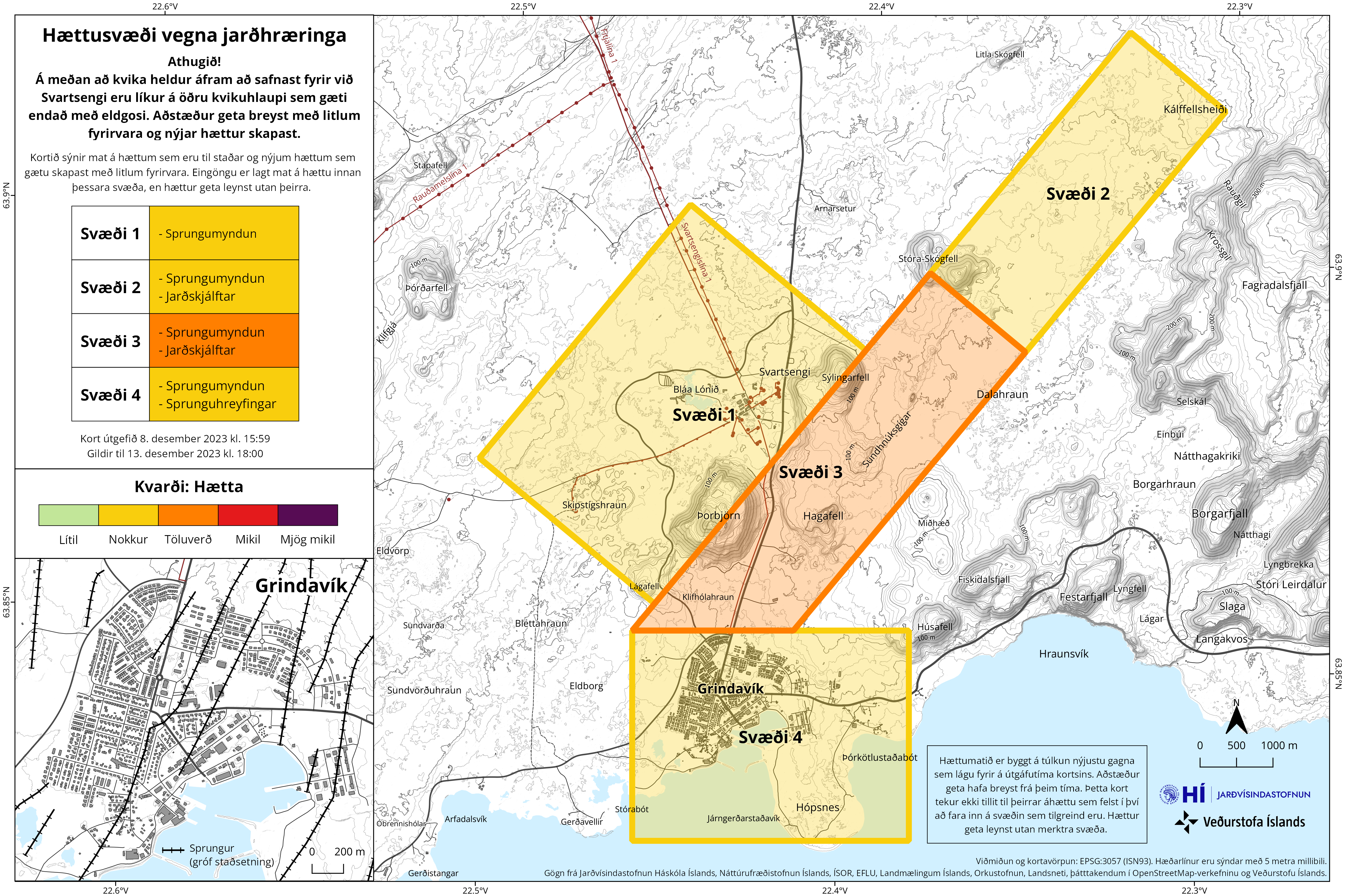
He did share this updated hazard map from IMO with an inset of Grindavik (which looks like Frankenstein’s monster, though here it is a case of humans’ disruption, not a wannabe god trying to create life):
December 7, 2023, 6:50 p.m., Pacific: Well, this is interesting:
Twitter translation: “The earthquake near Grindavik on the Reykjanes Peninsula lasted until around 10:00 UTC on the 7th. Epicenter distribution and cross section from the 6th, M-T diagram, and spatiotemporal distribution from November 22nd. Based on IMO earthquake source data.
From around 5 o’clock on the 6th, the number suddenly decreased. The last one so far is M0.1 around 4:00 on the 7th.”
In the same vein (of uncertainty re: meaning to this layperson) are some recent InSAR images; dates vary with the thread’s images, so please do check the Twitter translation, unless you read Icelandic:
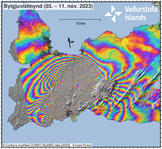
COSMO-SkyMed bylgjuvíxlmyndir, birtar á vef Veðurstofunnar um hádegið.
Sýna aflögun yfirborðs á Reykjanesinu frá bæði: 3. – 4. desember 👆 4. – 5. desember 👇 pic.twitter.com/F1WnFY0oFS
December 7, 2023, 2:07 p.m., Pacific: I see no new updates on the IMO main page since they summarized the Fagradalsfjall/Elvsdorp situation yesterday.
However, mbl.is reports today that the thermal area just east of the Fagradalsfjall system (if I’ve got the geography right) is expanding and that multiple small quakes are occurring there today: no interviews with geoscientists are included, though this layperson suspects that the journalists probably asked for some.
This persistent news coverage of that area and the apparent lack of official comment on it one way or the other are interesting.
It’s newsworthy. My guess is that the boffins aren’t sure about it and are keeping quiet until they can say something demonstrable regarding its potential meaning for Icelanders in the area.
My heart goes out to those scientists. It appears, after reading Volcano Cowboys — a book about the 1980 Mt. St. Helens eruption, among other things — that volcanic crises and their media coverage have the same psychological effect on scientists in responsible positions that a blender would have on their material form.
You have to be tough in so many ways to be a volcanologist!
December 4, 2023, 1:47 p.m., Pacific: Reportedly (autotranslated), magma might have stopped flowing into the dike that formed on November 10th; it’s still feeding the Svartsengi sill.
If it erupts, says the geoscientist quoted in that article, it still is most likely to erupt through the dike, which is the weakest crustal area now — most likely in the zone north of Grindavik that is already considered the highest hazard point.
Meanwhile, there were a couple of M2-ish quakes near Kleifarvatn today — a region east of the trouble spot but host of several triggered quakes during this crisis.
Could stress be building on the peninsula again?
I don’t know, of course, but here is Thorvaldur Thordarson’s view of the complex situation.
December 1, 2023, 8:49 a.m., Pacific: This isn’t news, but today’s IMO update does formalize what individual geoscientists have been telling media:
The event that began on October 25 with intense seismic activity that peaked on the evening of November 10 when the 15 km magma tunnel formed is not over. But it can be said with some certainty that a new chapter has begun where the same sequence of events can repeat itself.
At this stage, it is difficult to say when the next magma injection will occur and whether it will occur in similar directions. The National Weather Service continues to monitor the area carefully.
Sad news for Grindvikings, since IMO also reports that magma from Svartsengi is feeding the magma dike and is still active just north of town (Sylingafjall and Hagafell). They can’t go home until the inflow stops, and that doesn’t seem likely right now.
November 29, 2023, 3:05 p.m., Pacific: I noticed an M1-plus and M2-plus last night in the general Sylingafjall area north of Grindavik when I checked the earthquakes page linked above, but per IMO today (Google translated):
Seismic activity has continued to slowly decrease over the past two days. Yesterday, around 340 earthquakes were recorded near the magma tunnel, and since midnight today, around 150 earthquakes have been recorded. Most of the earthquakes are small earthquakes below 1.0 in magnitude in the area east of Sýlingarfell.
The speed of landslides at Svartsengi has decreased in the last few days, but its speed is still somewhat, or up to 1 cm per day.
Deformation data and modeling results indicate that most of the deformation is caused by inflow under Svartsengi rather than inflow into the magma tunnel. In other words, the expansion at Svartsengi now overwhelms the signals at the magma tunnel, but slowly diminishes all the entries. Inflow into the magma tunnel is limited to the area east of Sýlingarfell. Although the deformation and seismicity continue to decrease, there is still a possibility of an eruption, and if that happens, the most likely place is east of Sýlingarfell.
…Asked why the land giant is not accompanied by earthquakes, like before the big earthquakes in Grindavík on November 10, Benedikt explains that the earth’s crust is recovering.
He likens it to a balloon. It has not expanded enough for it to start trying and causing tremors. When the earth’s crust reaches its tolerance limit and the landmass becomes larger, earthquakes will probably start again.
“But we still don’t know what this area can withstand, or how much land is actually needed for the earth to start shaking again,” says Benedikt.
This also applies to magma, it is not known if the magma sill needs to be refilled so that magma flows out of it.
Could run in another direction
Asked if the magma could search in another direction, for example westward and out to Eldvörp, he says that it is not necessarily the case that the magma will again run under Grindavíkurveg and out into Sundhnúkagíga.
It is, however, the most likely thing in the situation, that she will go back to the east, because there is the least resistance there.
November 27, 2023, 3:32 p.m., Pacific: The news, when I checked it just now, is not extreme but is interesting. Since it’s a mixture of science and human interest, I summarized what I found at TalkWeather and will see how things develop over the next ten hours or so.
November 26, 2023, 6:36 p.m., Pacific: An earthquake swarm at the dike began less than three hours ago, per the 0157 geoscientist note (link to these notes is in the above info list):
Comments of a geoscientist
Seismic activity near Grindavík
Just before midnight, an earthquake began that lasted for over an hour. Since midnight, almost 175 earthquakes have been recorded at the magma tunnel, the largest being 3 in size at Sundhnjúk. A total of 700 earthquakes were recorded at the corridor on 26 November.
M3 is strong for this reduced-stress-field situation. We’ll just have to wait and see what, if anything, develops.
November 25, 2:40 p.m., Pacific: Some good news, per mbl.is (autotranslated):
By far the largest part of the magma tunnel at Svartsengi is solidified. The chances of an eruption are diminishing and the landfall at Svartsengi has slowed down. This is what Magnús Tumi Guðmundsson, professor of geophysics at the University of Iceland, says in an interview with mbl.is.
…
He says that only the land giant at Svartsengi has slowed down and he thinks it unlikely that the land giant will reach the same height before the end of the month as it had reached on November 10.
However, the article goes on to note that:
“There are several scenarios. One is that landris will continue under Svartsengi at a significant speed and in a few weeks a similar situation will occur as it was before this sequence of events,” he says and continues:
“However, the other thing is quite clear, the same pressure as before cannot build up. There is a weakness there. Now there’s a weakness where the passage is, and although it’s largely solidified, there’s still probably a connection [where the magma flows up].”
Meanwhile, today a group of geophysicists told RUV (autotranslated):
“If this one example is typical behavior for the Reykjanes, then once Eldvörp and Reykjanes are finished, activity should jump to the Bláfjöll and Krýsuvíkur system,” he says.
November 24, 2023, 5:48 p.m., Pacific: This from mbl.is (autotranslated) about four hours ago regarding that geothermal area east of the current zone of concern that was shifting (I forget which day, but it’s in the notes below):
An earthquake with a magnitude of 3.4 occurred a short distance northeast of Hellisheiðarvirkjun just before 9 p.m. this evening. Tremors were felt in Hveragerði.
The series of earthquakes began there earlier today, as mbl.is reported, but the earthquake is the largest in that series to date.
More smaller earthquakes have followed and the hail is still continuing, based on the latest measurements from the Norwegian Meteorological Agency.
Changes in ground temperature in the high-temperature area in Hveradälar by Hellisheidi were discussed in detail earlier this month. It is clear that the high temperature area is expanding.
Is it related to the Fagradalsfjall Fires? Something to do with the current low-level seismicity in Hengill, the next volcanic system over to the east? Something else?
That’s for the experts to say and I haven’t yet read of them addressing this geothermal movement yet. It may be unrelated, or they might be watching and waiting to understand it better themselves.
The inflation in Svartsengi is today around 140 to 160mm from 10. November 2023. The inflation each day is around 30 to 40mm.
The area that is inflating in Svartsengi is larger now compared to the area that inflated before 10. November 2023. This has created a uncertainty in the GPS data as I understand the situation. The rift valley is also creating issues in the GPS data as parts of him continue to sink and are going to continue to sink and lower nearby area with it. How much that is difficult to know.
November 23, 10:25 p.m., Pacific: Hmmm. Per mbl.is (autotranslated):
Páll Einarsson, professor emeritus at the Faculty of Geosciences of the University of Helsinki, says that it is possible that a new magma corridor is forming in light of the land relief that is currently being measured in Svartsengi on the Reykjanes Peninsula. Páll also says that the situation is currently complicated, but in the next few days it will perhaps be possible to assess whether the magma in the tunnel under Grindavík has solidified.
Still too early for this lay outsider to get very concerned about a new dike, but given the source, it’s definitely something to keep in mind as this event continues to unfold.
November 23, 2023, 2:17 p.m., Pacific: No news of change, per IMO. As the sill continues to inflate, I’m enjoying the RUV cam views — the landscape visible through the cams looks amazing with snow cover!
The Southern Volcanoes and Natural Hazards Group did a post (Facebook translates it) on the similarities between these Fagradalsfjall Fires and those of Krafla in the 1970s.
(Sigh. The only reason i continue my Facebook account is because so many overseas volcano-related official agencies use it. I wish they’d use the open Web instead.)
November 22, 2023, 12:27 p.m., Pacific: Storm effects (wind and waves) are obscuring signals of smaller quakes, but even taking that into account, it does appear that seismicity has decreased.
That said, the same area that inflated before is inflating again, and there are a number of ways that could develop.
This is a per IMO’s current update:
Updated November 22 at 18:15
About 300 earthquakes were recorded yesterday and 100 earthquakes have been recorded since midnight, which are much fewer than in recent days. There has also been a reduction in earthquakes over 2.0 in magnitude. By the end of the day, weather and waves continue to affect the sensitivity of the system to detect the smallest earthquakes.
Deformation and inflow associated with the magma tunnel continues to decrease. Landris at Svartsengi continues at a similar pace. Model calculations, based on data from November 21, indicate that inflow into the magma tunnel is greatest at Sundhnúksgíga, about 4 km north-northeast of Grindavík. Small movements have been detected within the sigdal in and around Grindavík in the last few days.
There is still a possibility of an eruption in the area above the magma tunnel. It is most likely that magma will emerge in the area between Hagafell and Sýlingarfell. As deformation, seismic activity, and inflow into the magma tunnel continue to decrease, the likelihood of eruption decreases over time.
Based on the latest data and taking into account the development of the activity since November 10, the probability of a sudden eruption within the town limits of Grindavík has been decreasing every day and is today considered low. It can be assumed that the magma in the tunnel under Grindavík is partially solidified, which also reduces the likelihood that the magma will suddenly break its way to the surface within the town limits. However, it should be noted that there is still a possibility of a volcanic eruption over the magma tunnel, and the most likely area for the source of an eruption is between Hagafell and Sýlingarfell.
It is important to note that there is strong evidence of a connection between magma accumulation in Svartsengi and the formation of the magma tunnel on November 10. Models indicate that the magma in the intrusion that formed the ledge under Svartsengi ran east to Sundhnúksgígir and subsequently formed the magma corridor with the great upheavals that then occurred. While landfall in Svartsengi continues, it can be expected that the magma that is accumulating there will be able to run again. In doing so, it could flow into the magma tunnel that now lies under Grindavík. It can also be expected that a new magma corridor can form, for example, to the west of the land giant at Svartsengi. Premonitions of such a scenario could be detected on seismic and GPS monitors.
The risk assessment map from the Icelandic Meteorological Office has been updated today, November 22. The map is revised in line with the development of the functionality. (Google translation of IMO caption.)
How would you manage this complex emergency?
November 20, 2023, 3:07 p.m., Pacific: There is still no eruption. The main news is a widening of the hazard zone —
Per Jón Frimann, “The current danger zone map from Icelandic Met Office. Zone A (orange) is the least dangerous area. Zone B (Red) is a dangerous zone, risk of fissures opening up, erupting crates, lava flows and gas pollution. Zone C (purple) is the most dangerous zone, Its close to same as zone b, but increased risk of dangerous volcano gases and entering it requires wearing a gas mask, have a gas and have gas measurement tool when going into the zone. Red dotted line is the estimated location of the dyke. This map also shows fissures in this area and the rift valley.”
— and a new livestream: a webicorder set up near Hagafell showing RSAM as well as regular tracing.
This article (autotranslated) shows images of Grindavik taken this morning.
Many homes and building are fine, but you can see some sagging. Also, that big crack across the intersection is much deeper.
An IMO director reportedly told mbl.is (link autotranslated):
We can read two things out of it. It can be all about calming down and relaxing in the hallway and the sequence of events fades away. We have also seen similar signs just before an eruption. We can’t rule out yet that that’s what’s coming. There is a lot of uncertainty around this and it is difficult to estimate the probability of whether it is going to happen. We just assume that there may be an eruption.
Regarding the triggered earthquakes (the Google translation is a little iffy here):
Benedikt Gunnar says that the earthquakes in and around Grindavík in the last few weeks have an effect in the rest of the country, and there are signs, for example, that Selfoss has moved considerably from Reykjavík.
“We see posts very far away from Grindavík. I haven’t started looking at the exact posts on Selfoss, but they could be one centimeter. This is related to the magma run that happened on November 10th. It caused huge displacements far away and is very similar to what we saw in Bárðarbunga. There we saw posts all over the country, but there is less of it now.”
November 19, 10:19 p.m., Pacific: The seismic microswarm ended at a little after 3:30 a.m., with a high-end M2 quake, and per the latest geoscientist note, things are back to the earlier level of activity.
This came out Sunday afternoon:
Inflation at Svartsengi is now rising much faster than it did before the earthquake on November 10, or about 5.5 times faster. Then the inflow of magma is about ten times more, ~50m3/s ..says Thorvaldur https://t.co/m2XJiCV7w4 via @mblfrettir
November 19, 7:29 p.m., Pacific: Per RUV, posted two hours ago:
Small earthquake activity has decreased again
However, small seismic activity over the magma tunnel under Grindavík has decreased after it increased shortly after eleven o’clock last night.
Einar Hjörleifsson, a natural hazard expert at the Icelandic Meteorological Office, says the activity is steadily falling to the same level as before. The largest earthquake over the magma tunnel yesterday was 2.3 in magnitude, but shortly after midnight a magnitude 2.6 earthquake was recorded.
It originated at the northern end of Hagafell, but the small earthquake activity is greatest around it and north of Stóra-Skógfell. Yesterday, more than 1,500 earthquakes were recorded over the magma tunnel. According to Einar, there are no signs of an eruption, but developments will continue to be closely monitored.
Here is that place name graphic again:
November 19, 2023, 5:13 p.m., Pacific: From TalkWeather; experts reportedly are reviewing this and the land rise, and will probably have more to say on it tomorrow during the day.
Microswarm in the expected vent area (Twitter will translate). This particular one is apparently over now, but read the whole thread, begun within the hour:
Grindavíkurmælirinn er farinn af stað með mikilli virkni undanfarnar 15 mínútur. pic.twitter.com/GMB4D6DDp1
Last post, per Twitter translation: “Micro-earthquake activity has increased at the vent. Einar Hjörleifsson, a natural hazard expert at the Icelandic Meteorological Office, says between 50-70 earthquakes have been recorded every hour today. He says this is certainly an increase compared to the last few days and that developments will be closely monitored.”
November 19, 2023, 1:18 p.m., Pacific: Hat tip to RUV. Here we go again.
Nuove analisi satellitari: la penisola di Reykjanes continua a deformarsi in maniera complessa. L'area della Blue Lagoon è tornata a sollevarsi, mentre l'area di #Grindavík continua ad affondare, seppur più lentamente. Il dicco è ancora alimentato, ma siamo in una fase di stallo. pic.twitter.com/A4aHWiHm1c
Per Twitter translation, “New satellite analysis: Reykjanes Peninsula continues to deform in complex ways. The Blue Lagoon area has started to rise again, while the #Grindavík area continues to sink, albeit more slowly. The dike is still fed, but we are at a standstill.”
Of note, someone on Twitter does note that IMO has changed the wording of their “alert” banner on their vedur.is website to “High likelihood…”
For geonerds, this new paper is getting much coverage:
November 18, 2023, 11:36 a.m., Pacific: These images released today answer my question about whether magma will break out somewhere else (images: Nov. 11 on left and Nov. 18 (first tweet?/Nov. 17 (second tweet, different scale):
COSMO-SkyMed bylgjuvíxlmyndir birtar 09:31 í morgun.
The Earth flexed all that muscle (shown left) to break open the seemingly innocuous dike.
Seemingly.
Per a geoscientist at today’s Civil Defense meeting, as reported by mbl.is (autotranslated):
…
“The magma tunnel still continues to widen and deepen, but widens and deepens less in the last 24 hours than in the previous 24 hours.”
The magma has reached a very high level
This decreasing activity indicates that the magma has reached very high up in the earth’s crust, where it has already become very fractured, and does not need much fighting to reach the surface.
While model calculations still indicate that magma is flowing into the vent, it must be considered likely that it will erupt and that this increased probability will last for at least the next few days.
The data also indicates that the greatest widening of the corridor is around its middle, in the area west of Hagafell. Therefore, scientists believe that this area is the most likely source of eruptions.
“The consequences of such an eruption depend on its size and it is difficult to predict,” said Kristín…
I understand better what Jón Frimann was getting at yesterday: the sill, centered at the original point of concern northwest of Thorbjorn and near the Blue Lagoon/Svartsengi power plant, isn’t reinflating — at the moment.
It probably will start up again — in days, weeks, months, or years.
The question: Is that what it will take to squeeze out an eruption here, or is it more a matter of a packet of superficial magma that is not quite pressurized enough — yet, anyway — to burst out of the ground?
Come to think of it, the Litli Hrutur eruption this summer was surprisingly brief, compared to the earlier two.
So what?
Well, this layperson doesn’t know. But there, reportedly, magma is sitting ~10 km down in that dike after a brief surface episode. Now, a lot of magma (in the present sill) is sitting ~5 km down after a brief surface episode.
There could be a little hope dawning that maybe, if there is an eruption during this magmatic rifting event, it won’t be as big as previously expected.
As each day comes and goes without an eruption, the hope grows that perhaps there won’t be an eruption soon.
But there are so many variables. And over the long term there will be other rifting events — Icelanders are wise to prepare for a volcanic disaster on the peninsula. One, at least, is likely to come over the next century.
November 17, 2023, 5:05 p.m., Pacific: Woops! I posted what little science news there is over at TalkWeather.
The only thing to add is that no earthquakes occurred between 9 and 10 p.m., per this report (Icelandic) at around 11 p.m., local time. However, this site shows plenty of them:
That geoscientist’s opinion doesn’t accept the notion that seismicity drops before an eruption here.
It isn’t the first conflicting statement I’ve seen from geoscientists in interviews. Scientists are people, too; also, the data are open to different interpretations.
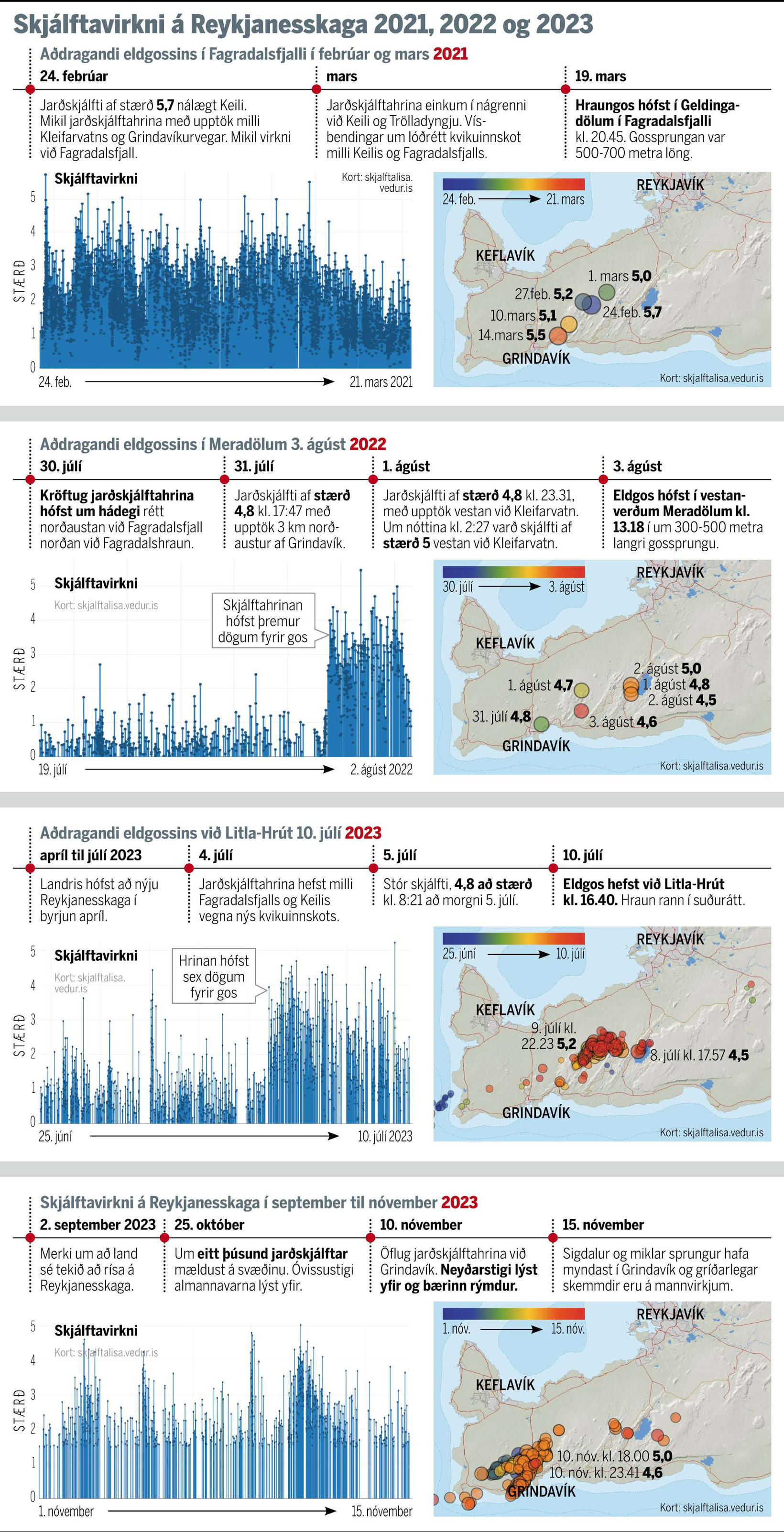
November 16, 2023, 6:14 p.m., Pacific: Still waiting — just wanted to pass along this neat graphic of the different seismicity patterns before the last three Fagradalsfjall eruptions:
They don’t mention the first one, at Geldingadalir in 2021, but you can see the intense seismicity that preceded it.
As for the next two, they write:
As you can see in the attached graph, seismic activity in the run-up to the last three volcanic eruptions on the Reykjanes Peninsula was different each time. In the eruption in Meradölum in August 2022, the earthquake began three days before the eruption, but when the eruption began at Litla-Hrút this summer, the earthquake had lasted for six days. A state of emergency was declared and Grindavík was evacuated last Friday following the start of a powerful earthquake.
Thus far, as of the 16th, it has been six days.
But the scale of this current intrusion, this layperson wonders if it helps much to draw comparisons with the last three, much smaller magmatic events.
November 16, 2023, 1:05 p.m., Pacific: There just is nothing much to report other than “lots of magma movement underground and no eruption.”
From the latest IMO report:
Updated November 16 at 17:50
The seismic activity at the magma tunnel has remained fairly constant between days. At 17:00 today, around 1,400 earthquakes have been recorded since midnight, the largest one measuring 2.9 and it was recorded at Hagafell just after 13 today. Most of the earthquakes were under magnitude two, and the most intense activity is at Hagafell.
Deformation associated with the magma tunnel continues, although it has slowed slightly since yesterday. The latest models that have been calculated based on GPS measurements and satellite data still indicate that the greatest slip in the magma tunnel is north of Grindavík near Hagafell. If magma does make its way to the surface, it’s still most likely to be in that area…
One has to wonder where the forces that are accommodating that inflow (which is occurring at high rate, per Jón Frimann) are working.
Since IMO reports deformation, i.e., rifting (down drop), could these forces be widening the tunnel? Could the land be storing up energy to release as a big quake? (IMO has reported that quakes up to M7 can happen on the peninsula, and they will be shallow ones because of all the hot rock 5-10 km down, so — bad, if it happens.)
Jón’s update yesterday was sobering. Among other items, he noted:
Part of the harbour area has started to sink according to news. I am not sure how much, but I think it might be considerable sink.
Speed of the sink in some areas of areas inside Grindavík has increased from 7 cm for each 24 hours to 12 cm for each 24 hours since yesterday. Some areas inside Grindavík have lowered as much as 2 meters or more.
Inflow of magma into the dyke continues to be at 75 m3/second according to news reports today. This is a lot of magma inflow into the dyke. The eruption in Holuhraun in 2014 and 2015 had an flow of 90 m3/sec when it was the most.
It is reported on mbl.is that it is now considered that magma might be flowing directly from the main magma chamber at 20 km to 40 km depth under this location in Reykjanes peninsula…
This shook a lengthy TalkWeather post out of me — those wonderful weather people are so patient with this volcanophile! ♥️ — because it seems to me that most of us laypeople outside of Iceland really have nothing but disaster movies for reference when hearing news about these quite normal, but tragic, mid-oceanic spreading ridge processes.
And movies are about entertainment, not facts.
So, I’ll just keep an eye on the cams, go through the news, and see how this goes.
November 15 14, 7:05 p.m., Pacific: Both RUV and mbl.is report increased earthquakes over the last three hours but an IMO representative is quoted as saying there are no signs of an eruption.
Of course, the IMO has been saying consistently that there might not be any precursory signs because of that huge release of tension on the 10th.
According to mbl.is (autotranslated), most of the quakes are around the Sundhnúka craters (where the cams are), especially in the region north of Grindavik and around Hagafell.
Here is the Idaho geology professor’s update on today’s biggest event thus far — the detection of SO2 in Grindavik and the subsequent rapid departure of residents who had returned for belongings. (The animals reportedly are safe — including these comfortable cats — but apparently some sheep are wandering around the plains somewhere.)
Dr. Willsey’s mention of Kleifarvatn lake reminded me of a video from 2020, when the biggest news on the Reykjanes Peninsula was earthquakes (see the Fagradalsfjal Fires post for info on how that developed).
I watched it again, and you can, too, though you will need patience and, perhaps, captions enabled.
I was amazed by the relevance:
Kleifarvatn is smack dab in the middle of the Reykjanes spreading ridge. (I wonder if Grindavik, on November 10, 2023, was juuuuust on the wrong side of the Eurasian plate edge, which might now be tilting the town (very much layperson speculation).)
He suggests — in 2020, long before lava had broken the surface in Geldingadalir — that the ridge is having an injection of magma underneath (get ready) the Blue Lagoon, the Svartsengi power plant, and Grindavik.
He goes on to say that the eruptions here will not be catastrophic — just that effusive volcanism on the peninsula, like what has been seen in the past, might be waking up again and may go on for a while.
I’d say he called that, and the spectacular eruptions we have already seen, well.
The mbl.is graphic in this article shows how “empty” of lava the Keilir-Fagradalsfjall-Grindavik segment is, compared to its neighbors.
Looks like Nature has decided to remedy that, and those protective lava barriers Iceland’s officials are debating will be necessary for a while here, no matter how this current crisis plays out.
November 14, 2023, 2:37 p.m., Pacific: An explanation for that orange — it was apparently seen tonight and viewers called RUV:
A working light in the west of Grindavík raises questions – Eruption not the sea
Many of those who have watched the live stream on RÚV’s webcam of Þorbirn were startled by the bright lights under the mast west of Grindavík.
The newsroom has received several inquiries about whether a gas crack has opened there, but it is not, nor is it a working light. [That’s probably a mistranslation, given the headline.] This is confirmed by a natural disaster expert at the Icelandic Meteorological Office.
There’s no geologic news yet.
Of note, I took another look at the blogging this past July for the leadup to that Litli Hrutur eruption and was amazed by the similarities to current events, though these are on a larger scale. Here it is again.
November 14, 2023, 10:45 a.m., Pacific: That wasn’t “it” last night, as the separate post shows.
This morning, little is changed, per the latest IMO update. They had let people into Grindavik but cleared them out again when sulfur dioxide levels were detected by newly installed equipment that sounds like some sort of COSPEC instruments.
That raises some questions:
The gas did not just appear when they turned on the instruments, but no one noticed gas effects while standing just 800 m or so above a new magma dike?
From results I’ve read about at other volcanoes, detectable SO2 peaks are detected when rising magma is kilometers underground.
This close to the surface, especially with basalt, everyone who has been in the area since Friday should have noticed it by now, even in that coastal setting.
They let people back in without doing gas readings first?
Are ground temperatures being monitored there, and if so, are they elevated?
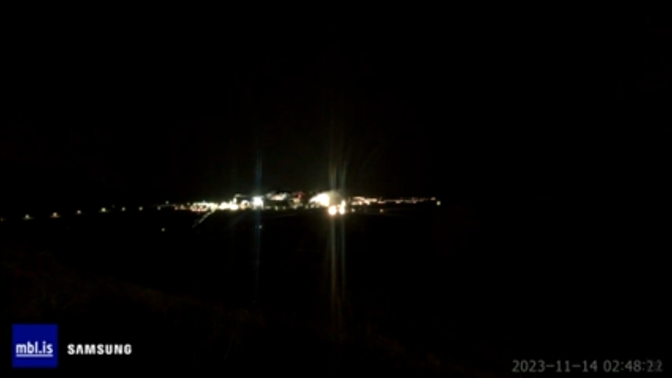
I won’t push this, since I came a cropper yesterday over the cam images like this —
It’s blurry, but there is a distant orange lava-incandescent-like light beyond the power plant, if you zoom in, that appeared while I was watching. I thought it was an eruption, but no one confirmed it and the same view of the plant via another cam host did not show the orange light a few hours later.
— but I think those are valid questions.
I don’t know if it is relative, but yesterday I commented on Jón Frimann’s blog and asked if SO2 measurements from Grindavik were publicly available.
In other news, there are some M3-ish quakes happening in areas farther from Grindavik and also from the original center of concern. I’ll continue assuming that they are trigger quakes and not directly related to volcanism.
November 13, 6:36 p.m., Pacific: Think this is it, out behind the power plant. In the last 20 minutes, the steam stopped and they turned up the spotlights.
Update, 11:24 a.m., Pacific: IMO just described the SO2 detection and instruments used here.
They don’t sound too sure about the sulfur dioxide source.
Update, 3:24 p.m., Pacific: More information from a volcanologist:
Update on the potential SO2 detection near Grindavik: the levels that were detected were low, and it's currently unknown if they came from the magma in the dyke or, e.g. the cooling lava from previous eruptions 🧵
November 13, 2023, 2:56 p.m., Pacific: Per Jón Frimann’s update today:
…
The inflow of magma on Friday 10. November 2023 was 1000 cubic meters per second according to Icelandic Met Office and experts.
The rift zone that is lowering is on the western side of the Grindavík town. The east side is rising up to almost the same amount. Parts of Grindavík have lowered around 1 to 2 meters. Some of the cracks in the grounds are up to 20 meters deep or deeper.
…
November 13, 2023, 12:24 p.m., Pacific: Incredibly, the wait for an eruption continues.
The IMO shared (autotranslated) some mind-boggling satellite images and other information.
They note that there is almost a cubic kilometer 7 million cubic meters of magma down there, and here is how it has deformed the peninsula:
There is no mention of the Eldey quakes of last night, and I think that, with all respect to the former president, those were probably triggered, as quakes in other areas have been, as regional stress field adjustments needed to accommodate this enormous deformation.
Yes, the question arises whether these adjustments will lead to activity in other volcanic systems. I don’t know that anyone has the answer — at least, I haven’t seen any indications of one.
Jón Frimann (who has been spot on so far) still isn’t sure if this magma is part of the Reykjanes or Fagradalsfjall system. Some tweeters note snappishly that “of course it’s Fagradalsfjall!” but I have been wrong too many times in my long life to go with snap judgment in such a complicated event as this:
The scale is much larger than anything produced in the last three Fagradalsfjall Fires (BTW, I missed the Litli-Hrutur 2023 one in that post).
IMO noted (autotranslated) exactly one month ago that there was magma 10 km below Litli-Hrutur and another eruption there can be expected in coming weeks to months. That’s definitely the Fagradalsfjall system.
During the current crisis, I’ve seen mention that magma is still 10 km down there.
Yet huge amounts of magma are also up here.
So having two different magma systems active in the region is quite possible, though not proven.
The Reykjanes Peninsula has very complicated geology. I tried looking up some background on it at Google Scholar and was amazed at all the papers trying to explain it. So there is nothing “of course” about this.
Earth has raised one of the “cracks” (mid-oceanic ridges) that it uses to release inner heat from the seafloor up to Iceland for puny H. sapiens to contemplate. It is currently giving geoscientists a lesson, and all any of us can do is hope that as few people as possible suffer from it.
The other image that IMO released today shows a significant rift down-drop from Friday’s quakes — apparently Google mistranslated as “sinkhole” whatever the Icelandic for it is.
Grindavik is in it.
The blue and purple areas have sunk by as much as 1 meter, per IMO.
It probably continues offshore, but InSAR isn’t picking it up.
I don’t know what to expect next.
[LAYPERSON OPINION] Looking at that image again —
— everything on the right, in the most intensively deformed part, seems to be blocked by the next ridge series over. (See note in one of the recent updates below about a geothermal area shifting position.)
And, interestingly, there seems to be a tiny circle of less deformation in the very center of that intensely deformed area — presumably above the main magma inflow conduit.
At the moment, Friday’s big swarm and the dike formation have released pressure, but presumably more pressure needs release, as those triggered earthquakes show.
Oddly enough, that pressure hasn’t forced magma out of this very shallow dike under Grindavik and environs. I don’t understand that.
Will it, eventually?
Or will pressure cause another dike to form somewhere else?
Or [name your preference]? My “out there” guess is that, because the downdropped area, though mild, on that second image extends northwestern beyond the hills that include cam hosts Thorbjirn and Sylingafell, and there is nowhere seen as strong an uplift as on the right, maybe the rifting isn’t over: rift valleys on all scales have two walls.[/LAYPERSON OPINION]
Well, back to the cams and, hopefully, the Amazon Vella post on jaguars that I sat down to write on Friday.
Would that many Icelanders could get back to their routines so easily!
November 13, 2023, 12:02 a.m., Pacific: I had wondered about Eldey after seeing the M3.5 and other strongish quakes there, not sure if it might be just a tension release triggered by the regional or else connected with the Grindavik magma tunnel.
Eldey does have its own volcanic system, but this tweet by a former president of Iceland indicates some concern:
The biggest earthquakes are now close to the island #Eldey, out in the sea, short direction from #Grindavik and the #Reykjanes peninsula. Therefore eruption could be on the seabed. Adding a powerful dimension to the uncertainty. Enhanced suspension for all concerned. pic.twitter.com/oJByAkxpQg
Otherwise, another quiet night with lots of low-level seismicity, and everyone sounds on edge.
“Look for the street lights to go out in Grindavik. We’ll see that before lava,” tweets one person.
Another is glued to a cam that overlooks the whole dyke area (RUV’s new Thornbjorn cam).
Me? After noting that some of the small quakes below the power plant area are shallow, I choose to watch that mbl.is cam. All night.
And nothing. Anywhere.
What makes it so scary is the contrast to that intense activity on Friday.
I shouldn’t be talking about it all, here in the nice safe Oregon night — time out for a Cascadia megathrust earthquake 😉 — how difficult it must be for Grindvikings and all Icelanders.
I wonder if they know the world is with them on this and wishes them well.
November 12, 4:12 p.m., Pacific: It’s a mixed bag today.
There are no dramatic changes yet, which is nice, but the magma isn’t going away, either.
To start with, here is a US geology professor sharing his interpretation of events through earlier today:
Hours after that, IMO did an update, and a few hours later, I got online and described that in three. TalkWeather. posts
That shortcut was necessary because it looks to me that things are wide open, in terms of possibilities, and I wanted to just do the update first and then take a step back here and review the situation.
The area of concern, about 4-5 km down, was originally in the general Thorbjorn/Blue Lagoon/Svartsengi power plant area.
On Friday, November 10, intense seismicity broke out —
This is amazing to watch! At 25s, you see the activity near Blue Lagoon, where the sill was located. Then, by 30s, you see the quakes shift east. There, the magma likely found a weakness in the rock, because the seismic activity quickly acceleration in both directions, NE and SW. https://t.co/k2gY3GTKta
— as a dike a little farther west opened up, at a minimum depth of about 800 m, and headed south, moving under Grindavik and out to sea for a few miles. No eruptions ensued, but vertical ground displacement was as much as 120 cm (almost 4 feet). Grindavik was evacuated and parts of the town sustained damage. A nursing home was actually ripped apart and the nearby geothermal heating pipe supplying that part of town was broken.
From that point on, only low-level seismicity has occurred — according to the Iceland Met Office, because of the release of tension during that intense seismic swarm. Earthquakes are still frequent, and the boffins are currently tracking them.
Today, a sink hole, about 1 meter deep, was found inside Grindavik town limits. No one knows its age, but it does reportedly indicate that magma has risen closer to the surface under Grindavik.
Meanwhile, eruption at the original site of concern is a possibity, according to a University of Iceland volcanologist (autotranslated). However, because of the human presence, experts right now are focused on an area closer to Grindavik.
As mentioned below, wherever this occurs, they are looking at an eruption that could be larger than Holuhraun (fissure length 0.8 1.8 km) but not as big as Laki in 1793 (fissure length 25 km) — perhaps with a fissure just under two kilometers long (correction:) 8 km long, per this story). If it erupts.
Wherever it broke out, such Holuhraun-Plus eruption size would destroy a lot of stuff and damage even more — most of Iceland’s people live in the Reykjanes area, though the capital, Reykjavik, is about 25 miles from the trouble zone. Any accompanying quakes, which could get up to M7 per IMO, also would cause severe damage throughout the area.
So, we’ve got a large amount of magma rumbling around about 5 km underground (or less) plus even more in the older Fagradalsfjall eruption sites but twice as far down; a rifting event on the 10th that moved some magma to a new area, damaged a town, causing its evacuation, and then went out to sea, bringing in all the associated hassles of a possible Surtseyan eruption just offshore; there’s a large population potentially at risk; and lots and lots of uncertainty because the geology here is quite complex and no one can directly observe what the molten rock down there is actually doing.
Like I said, wide open.
Assuming that events don’t move with breakneck speed, as they did Friday, I’ll just blog the science of it here (from a layperson’s viewpoint). If people are suddenly threatened, TalkWeather has more readers and news types who follow such events in weather and possibly might be able to help out somehow, or at least get the word out, if sudden volcanism breaks out on the Reykjanes Peninsula.
November 11, 2023, 11:46 p.m., Pacific: The big meeting broke up just a little while ago. This IMO tweet and linked article sum up the new
The rate of ground deformation is much higher than has been measured previously on the Reykjanes Peninsula. Around 800 earthquakes have been detected since midnight. The likelihood of a volcanic eruption occurring in the near future is deemed considerable. https://t.co/9vYBBjNcX9pic.twitter.com/RRV7adJDsG
— Veðurstofa Íslands / Icelandic Met Office (@Vedurstofan) November 11, 2023
The Prime Minister made a statement; the RUV news mentioned bills for funding of infrastructure protection throughout the peninsula; and I was starting to get Laki jitters when one of the coauthors of that linked paper reportedly said it could around the size of Holuhraun, which is better although still bad news for many Reykjanes residents.
Read the whole interview, though. It’s interesting.
November 10, 2023, 10:15 p.m., Pacific: This is just mind-boggling.
Líklega eru þetta gervihnattamyndirnar sem um ræðir.
I’ve been seeing some unofficial comments from people who seem reliable about there being more than one volcanic system involved here.
Now it’s possible to understand their concern. This appears to involve a sizeable cunk of the peninsula (whose geology is already challenging even for the boffins).
In the news: They evacuated Grindavik successfully a couple of hours before they were able to confirm that the dyke does go right under town.
Quakes quieted down a bit but now are picking up and southwest of Grindavik.
The IMO is meeting at this time to review the situation.
This is bigger than usual and there are so many uncertainties.
Not good. Not good at all. But we shall see how things turn out.
November 10, 2023, 3:46 p.m., Pacific: What a nightmare. I fear this will be big, too. Hope I’m wrong.
Quick display of IMO's earthquake locations the last 6hrs using https://t.co/fsAt8MbJd1. A good,free tool to play with. It certainly looks like a dyke intrusion propagating both SW and NE from Svartsengi. Note that seismicity indicates that the dyke reaches under Grindavík town pic.twitter.com/Ez4pHJQsTl
November 10, 2023, 3:29 p.m., Pacific: They’re evacuating Grindavik: RUV is live blogging/streaming it (text will autotranslate).
And a lay Icelandophile notes:
This is going to be different from the previous 3 eruptions. The first 3 took place in the Fagradalsfjall System, this looks like it’s going to take place in the Reykjanes Volcanic System. This is why there are many more unknowns this time #Iceland#Reykjanes#Earthquake
November 10, 2:31 p.m., Pacific: It’s coming. See the two IMO links above.
⚡🇮🇸 #Iceland – This impressive video comes from #Grindavík, the city closest to the intense seismic sequence underway in Iceland at the moment. The tremors are felt practically continuously.#earthquakepic.twitter.com/TRKPmoy4vc
November 9, 2023, 2:09 p.m., Pacific: There was a combination of social and geology news that seemed best to put in a TalkWeather thread.
In terms of geology, there have been no more strong swarms yet, though cracks are appearing in local roads (small ones — the sort of things that happen with any quakes.
The boffins reportedly (autotranslated) have set up more GPS stations to pick up surface deformation better if and when magma starts to rise.
No news is not necessarily good news in such a situation. [Layperson speculation] I think the magma under the Thorbjorn area might be starting to release its gases, though last night’s swarm could also have been from some rocks failing briefly. If it’s exsolution, those gases have nowhere to go and pressure will build up…
In any event, it doesn’t seem as though this new sill is going to just sit there, inflate, and then harden in place (which would be nice).[/Layperson speculation]
The most interesting news (autotranslated) this morning was that a geothermal area a four-hour drive inland from Grindavik has begun to shift around.
As far as I know, it’s an unrelated system and an unrelated event, but it looks on the map as though it could be on the outer edge of the current seismicity and so might be something to keep an eye on.
Too, it apparently also is shifting underneath the local part of Iceland’s Ring Road, which might be a factor if evacuation of Grindavik and environs is necessary, particularly if any eruption turns out to be big and/or widespread.
November 8, 9:29 p.m., Pacific: Per the IMO geoscientist note:
Just after midnight, a powerful storm started near Þorbjörn and Sýlingafell with an earthquake of magnitude 3.9. at 00:02. At 00:13 another earthquake of magnitude 4.2 was recorded and at At 00:46, the largest earthquake measured almost 5.0 in magnitude. About 400 earthquakes have been recorded, of which 18 were over three in magnitude recently at 02:56, 4.3 in size. The earthquakes have been felt in many places in the Southwest corner.
More than 22,800 earthquakes have been recorded in the earthquake series that began on October 25 at Þorbjörn. A total of six earthquakes have been measured above magnitude 4, the largest measured magnitude 4.5 at 8:18 on 25/10.
There apparently is no sign of lava yet. RUV has a web-linked cam atop Thorbjorn that currently is panning.
Will embed videos as things develop.
November 6, 2023, 8:19 a.m., Pacific: Well, this is not good (since that magma likely will find its way to the surface somewhere). Per IMO about four hours ago (via Google Translate):
Updated November 6 at: 12:40 p.m
In the last 24 hours, about 1,300 earthquakes have been recorded on the Reykjanes Peninsula, of which three earthquakes are over magnitude 3. The largest earthquake occurred about 3 km NE of Þorbjörn and measured 3.6 at around 7 this morning.
Deformation measurements show that landris continues in the area NW of Þorbjörn and there are indications of an increased rate of expansion since Friday, November 3. Since October 27, land has risen by 7 cm according to GPS measuring station in Þorbirn. The deformation is caused by the accumulation of magma in a sill at a depth of about 5 km. According to updated model calculations, based on data from October 27 to November 3, the shelf has become twice as large as the four shelves that have formed at Þorbjörn since 2020. Inflow into the shelf is estimated at 7 m3/s, which is four times faster than previous clip with Þorbjörn.
While the magma accumulation continues, seismic activity can be expected on the Reykjanes Peninsula because the magma intrusion causes increased tension in the area.
Here is an article (autotranslated) on the response. (By “hot water,” I think they mean heating — as I understand it, Iceland is completely reliant on geothermal energy — please correct me if I’m wrong).
Original post:
Iceland is on the Mid-Atlantic Ridge, as well as on a hotspot. When eruptions start in one place, they tend to continue (which is why Icelanders talk of the “[Insert place name] Fires” rather than a single eruption.
Well, yet another of the “Fagradalsfjall Fires” is looming, and this time it might affect people:
…Three escape routes from Grindavík if the town is evacuated… Civil Defense's evacuation plan for Grindavík is available, 3 escape routes out of town as well as escape routes within town and locations of the main institutions and collection centers.https://t.co/elBjwTUXZhpic.twitter.com/HwGrDZcfK3
From At 5 in the night, seismic activity began west of Eldvörp, which is about 6 km from Þorbirn. The largest earthquake was about 4.2 in magnitude and was felt in a built-up area. There is still considerable seismic activity in this area, although the activity has decreased slightly since that night. This is a case of so-called “thrust earthquakes” which are a reaction to stress release due to the magma intrusion at Þorbjörn and are not a sign of magma movements in the area of Eldvörp.
Judging by the latest deformation data, land rise at Þorbjörn continues at the same speed and there are no clear signs that the magma is moving closer to the surface.
More as it develops. For old blog posts, check the Iceland category (I didn’t follow in detail the Fagradalsfjall fires that were in the boonies, gorgeous as they were. This upcoming one, though, looks more hazardous.)
I couldn’t find YouTube cams Jon Frímann mentioned in his last post.