
- Status: Orange, but —
El nivel de actividad naranja 🔶 del VNR nos indica que debemos estar preparados para una posible erupción de magnitud considerable. Como existe la probabilidad de que el volcán alcance el nivel de actividad rojo, este es el momento de tomar medidas de prevención⛑️ pic.twitter.com/jRoZPkXZEG
— Servicio Geológico Colombiano (@sgcol) May 1, 2023
https://platform.twitter.com/widgets.js
The take-away here: Ruiz might wind up steadily, if that’s on its agenda, or it might just give them a few minutes’ notice before the “big one.”
- Interactive official hazard map (autotranslated), via Relief Web; En español
- USAID April 4th map (autotranslated) posted on May 18 at Relief Web.
- Links to webcams, public data, and other information.
- Update archive.
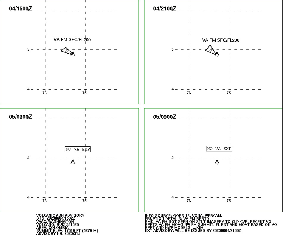
Update, June 4, 9:45 a.m., Pacific: VAAC issued, within the hour, a new ash advisory:
Here is the gist of today’s SGC bulletin, with their emphasis:
From 09:00 a.m. from yesterday (June 3) until the time of publication of this bulletin, the seismic activity related to the movement of fluids inside the volcanic conduits decreased in the number of earthquakes and showed similar seismic energy levels, compared to June 3. Some of the seismic signals were associated with pulsatile ash emissions confirmed through the web cameras used for volcanic monitoring.
At the same time, the seismicity associated with rock fracturing within the volcanic structure continued, which showed levels similar in number and in seismic energy to those registered on June 3. The earthquakes were located mainly in the southeastern sector of the volcano, up to a maximum distance of 3 km from the crater. The depths of the earthquakes varied between 2 and 4 km.
Regarding surface activity, the maximum height of the gas and/or ash column was 2000 m measured from the top of the volcano. Its preferential dispersion direction continued towards the northwest of the volcanic edifice. In the early hours of today, there was confirmation of a slight fall of ash in the municipalities of Villamaría and Manizales (Caldas). Additionally, the degassing of sulfur dioxide (SO2) and the release of water vapor from the crater to the atmosphere are maintained.
It is important to note that the activity of the Nevado del Ruiz volcano is still very unstable. Although several days have passed in which the seismic activity, in general, has decreased compared to previous weeks, it is important to remember that this does not imply that the volcano has returned to its normal levels of activity, so it is recommended not to get used to these oscillating changes of activity and thinking that it is a normal volcano behavior.
Satellite detection of significant thermal anomalies at the bottom of the crater indicates the presence of very hot material near the surface. Likewise, the recurrence of ash output sometimes pulsating and sometimes more continuously, the persistence of slight ground deformation, and variations in the output of sulfur dioxide, indicate that the volcano could still make a major eruption in days or weeks. It is also necessary to mention that on previous occasions, after presenting important changes in its activity, the Nevado del Ruiz volcano has shown a decrease in its activity before a major eruption. That is to say, first it registers a strong increase in its activity, then a considerable decrease and, later, it makes an important eruption.
Therefore, we reiterate that the activity of the Nevado del Ruiz volcano continues at ORANGE LEVEL, which indicates that there is a probability that in days or weeks it will erupt more than it has in the last 10 years. To change the level and return to the Yellow level, a prudential time is required where trends and patterns can be observed that allow us to infer the possible decrease in activity, aspects that the current activity of the volcano still does not show, reason for which warns that the level of activity of the Nevado del Ruiz volcano will remain at ORANGE LEVEL for several weeks. During this time, in the event of an acceleration of processes suggesting an imminent eruption or the eruption itself occurring, the level of activity will be changed to Red.
We recommend that the community remain calm, follow all the instructions of the National Unit for Disaster Risk Management (UNGRD) and local authorities, and be attentive to the information provided by the Colombian Geological Service on the evolution of the state of the volcano.
The COLOMBIAN GEOLOGICAL SERVICE will continue to monitor the evolution of the volcanic phenomenon and will inform in a timely manner about the changes that may occur.
For more information visit the following link:
https://www2.sgc.gov.co/Noticias/boletinesDocumentos/Forms/AllItems.aspx
And here is the hazard-map video that SGC shared yesterday (Spanish, but a YouTube translation app will work):
Still alert level ORANGE; we’ll see how things go.
Featured image: Ric Photography/Shutterstock
