
This repost is due because the massive mudflows haven’t been getting much news coverage in my neck of the woods, and also they make an introduction to this “geological serial killer” quite timely today.
Two videos of lahars this week are linked in the reply to this retweet:
"…the light blue color represents the area of the river/rainfall path. The 4 flow paths (light blue) are potential threats that must be watched out for." #volcano https://t.co/bbKFGSH4qr
— BJDeming (@BJDeming) July 10, 2023
https://platform.twitter.com/widgets.js
As you can see from the official diagram, the crisis is ongoing.
Original post, referring to the feature image at top of this post.
You have to see it to believe there can be such a place as this in the real world.
And many people call this home!
What are we looking at here?
For starters, we’re in East Java Province, on the island of Java, in Indonesia.
The smoking volcano in the distance is Mount Semeru. It’s one of the world’s few constantly active stratovolcanoes, erupting several times a day. (Photovolcanica)
Close up, what looks like a steaming hole in the ground in that video is Mount Bromo. Its walls actually rise more than 400 feet above the surrounding sea of sand-like volcanic materials.
By the way, that’s actually the name of the brownish flat area you can see around Bromo and its companions: the Sand-Sea Caldera (people usually skip the hyphen, but I use it because “Sandsea” sounds like an English coastal resort).
The small volcanoes
The hills around Bromo are all volcanoes, too, but they’re either inactive (like Batok, the sugar-loaf flat-topped cone with deeply eroded sides) or extinct. (Santoso et al)
Here’s a 19th-century bird’s-eye view to help you sort them out (notice, too, that these volcanoes and the surrounding Sand-Sea Caldera sit inside an even larger caldera that has steep sides)

Wikimedia, public domain.
Generally speaking, the central volcanoes, going from top to bottom, are: Batok, which is fairly young; Bromo, active; Widodaren, extinct; Segarawedi, extinct; and the Kursi complex, extinct.
The people
These stratovolcanoes sit in the Tengger caldera, whose steeply eroded walls look very dramatic in the above video.
The people shown are tourists standing on the northern caldera rim to watch the sunrise and, hopefully, get some shots of the dramatic Tengger volcanic complex before the daily fog rolls in at around 9 a.m.
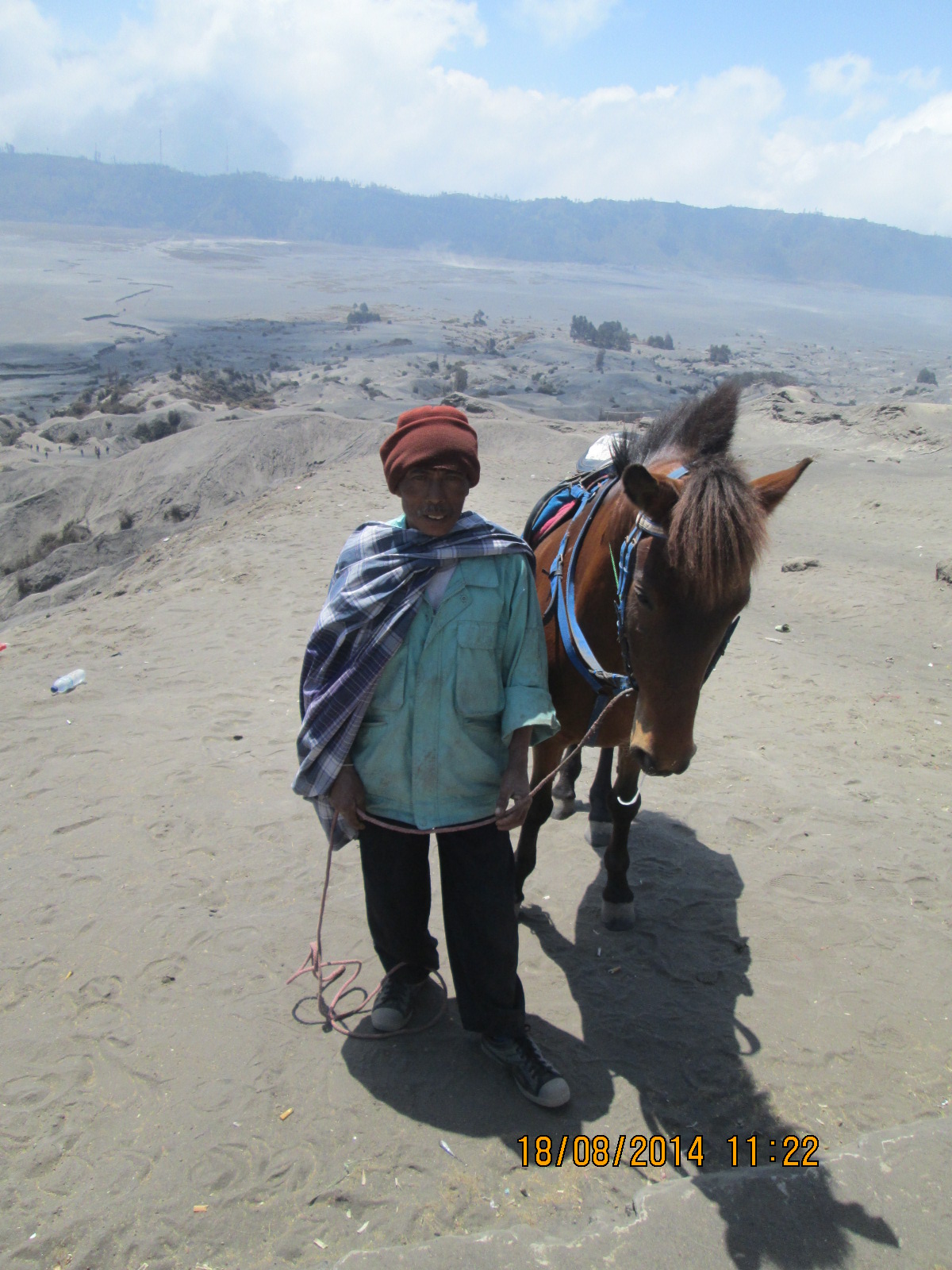
Yes, there are tribal ponies in this wide land, too. (Image: Rudolph A. Furtado via Wikimedia, public domain)
As you saw, the caldera-rim hills and valleys are inhabited. Tenggerese Hindus live here in about 30 villages.
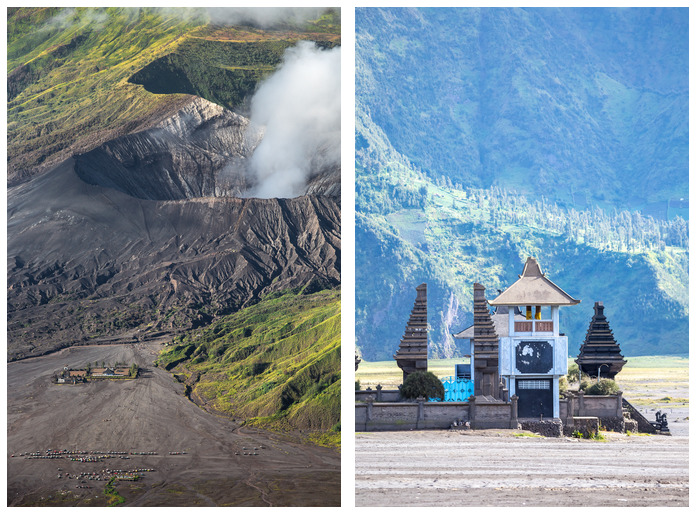
You have seen their temple at the foot of Mount Bromo. It is active, just like the volcano that it was built to honor.
Per Bachri et al., the Tenggerese cultural identity centers on Bromo as a spiritual being.
A sense of the scale here. (Images: Mazur Travel/Shutterstock, left; Pratan Ounpitipong/Shutterstock, right)
As seen in the video, people worship it at the temple and also at the crater rim.
Once a year, they throw produce, farm animals, and even money into Bromo’s vent.
But wait: it’s also acceptable for poor people to go down below the offering spot to catch the stuff.
They stand where that one man in the video was walking on the very edge of the steaming chasm.
Have you ever been so hungry, you would do something like that?
Nonbelievers may also use the staircase up to the rim, but from the Tenggerese point of view, they don’t have an “in” with Bromo.
Locals therefore were not surprised when an unexpected blast in June 2004 killed two tourists here and injured several others.
It may seem heartless, but the Tenggerese do walk their talk. In Bachri et al., there is a dramatic image of ceremonies at the temple in 2010 while Bromo was having a VEI 3 eruption right behind and above them!
The big calderas
Getting back to the local geography, you might have noticed on the bird’s-eye drawing that Tengger Caldera abuts an irregularly shaped, heavily eroded area to the northeast that also has steep walls.
Of course that’s a caldera, too. This is VolcanoLand here!
It’s called Ngadisari Caldera and is hundreds of millennia younger than Tengger.
If younger, why is it so weathered? Because this region gets a lot of rain, which drains out of Ngadisari through the Sapikerep Valley.
Of course, there is no umbrella over the Tengger complex, and it gets the same amount of rainfall.
But here, the runoff just flows out across the Sand Sea — Indonesia’s only desert-like environment — and disappears!

Part of the Sand Sea. (Image: Robert Machacek via Wikimedia)
No one really knows why, though it must have something to do with all that porous volcanic “sand.” (Zaenuddin)
Zaenuddin notes that, wherever it goes, the water does interact with magma somewhere down there, because Bromo’s eruptions are all steam driven (phreatomagmatic). Some of the other eruptions here in the past have also been phreatomagmatic.
A word about origins
Bottom line: Volcanoes erupt here, and throughout the Sunda Arc, because the Indo-Australian tectonic plate is subducting underneath Eurasia.
And that’s all there is about volcanism on Java that is simple. See Smyth et al., if you’re curious about details.
Per Zaenuddin, there are two hypotheses about how the Tengger complex formed.
- There used to be two volcanoes here, each about 13,000 feet high.
- There was one huge volcano, almost 15,000 feet high.
Either way, as I understand it, there was a huge caldera-forming event around 820,000 years ago that gave us Tengger Caldera, followed by another blast roughly 150,000 years ago that produced the Ngadisari Caldera.
The Sand-Sea Caldera eruptions happened in a series during the late Pleistocene, starting around 33,000 years ago, and went on for a little while after the last ice age ended.
Bromo & Company, out there in the Sand Sea, are much younger than that.
They built themselves up over the past several thousand years, with Bromo still under construction today.
Semeru and Tengger
There simply isn’t enough room for Semeru today, though that is the most hazardous volcano of this group.
For that reason and also because Semeru is quite different from the Tengger volcanoes, it can wait until next week.
Suffice to say that it’s south of Tengger but connected to the complex by a massif — basically, a 350-square-mile collection of assorted old calderas, lava domes, cones, and explosion craters. (Solikhin et al.)
Location:
The Tengger Complex sits at 7.942° S, 112.95° E, in East Java Province, part of four regencies: Probolinggo, Malang, Pasuruan, and Lumajang. The Global Volcanism Program Volcano Number is 263310.
Nearby Population:
Per the Global Volcanism Program:
- Within 5 km (3 miles): 27,826
- Within 10 km (6 miles): 69,451
- Within 30 km (19 miles): 1,420,878
- Within 100 km (62 miles): 22,628,278
Current Status:
Bromo’s status at the time of writing is Normal/Aviation Code Green.
Eruptions:
- Eruption styles: Tengger has a little bit of everything, it seems: stratovolcanoes, lava domes, explosion craters (maars), cinder cones, and calderas.
Bromo, the only active site at present, has a lot of steaming fumaroles at baseline. As shown in the video up above, there can be low-level ash-rich emissions, too. Eruptions are steam-driven and therefore both sudden and explosive. More than 50 have been documented since 1804, with anywhere from a few months to many years between blasts. Per Photovolcanica, it apparently had a lava lake from 1836 to 1841 and then briefly in 1842.
- Biggest recorded event: Bromo usually has relatively mild eruptions, but it did reach VEI 3 intensity in 2010-2012, 1948, and 1915-1916.
The Global Volcanism Program lists a Sand-Sea caldera-forming eruption around 830 BC as VEI 4.
- Most recent eruption: 2019.
- Past history: See the Global Volcanism Program for details. The GVP also has an archive of Bromo activity bulletins from 1980 to 2019.
Monitoring:
The latest Bromo advisories (it hasn’t erupted since 2019.
Edited and link to bulletins corrected, August 24, 2020.
Featured image: Joel Santos/EPOD.
Sources:
Bachri, S.; Stötter, J.; Monreal, M.; And Sartohadi, J. 2015. The calamity of eruptions, or an eruption of benefits? Mt. Bromo human-volcano system a case study of an open-risk perception. Natural Hazards & Earth System Sciences, 15(2).
Brown, S.K.; Jenkins, S.F.; Sparks, R.S.J.; Odbert, H.; and Auker, M. R. 2017. Volcanic fatalities database: analysis of volcanic threat with distance and victim classification. Journal of Applied Volcanology, 6: 15.
Earth Picture of the Day. 2015. https://epod.usra.edu/blog/2015/06/javas-tengger-caldera.html
Pfeiffer, T. 2004. Bromo updates. http://www.decadevolcano.net/volcanoes/indonesia/tengger_caldera/bromo.htm Last accessed August 21, 2020.
Photovolcanica. 2011. Mount Bromo. http://www.photovolcanica.com/VolcanoInfo/Bromo/Bromo.html Last accessed August 21, 2020.
Smyth, H. R.; Hall, R.; and Nichols, G. J. 2008. Cenozoic volcanic arc history of East Java, Indonesia: The stratigraphic record of eruptions on an active continental margin. Special Papers-Geological Society of America, 436, 199.
Solikhin, A.; Thouret, J.-C.; Gupta, A.; Harris, A. J. L.; and Liew, S. C. 2011. Geology, tectonics, and the 2002–2003 eruption of the Semeru volcano, Indonesia: Interpreted from high-spatial resolution satellite imagery, Geomorphology, 138: 364–379,
Volcano Discovery. 2020. Bromo volcano. https://www.volcanodiscovery.com/bromo.html Last accessed August 21, 2020.
Wikipedia. 2020. Mount Bromo. https://en.wikipedia.org/wiki/Mount_Bromo Last accessed August 21, 2020.
Zaennudin, A. 2011. Perbandingan antara erupsi Gunung Bromo Tahun 2010–2011 dan erupsi Kompleks Gunung Tengger. Jurnal Lingkungan dan Bencana Geologi, 2(1): 21-37.
